Skip to content

pete grafton

Political & Social History, Music & Photography

  • Home
  • Photography
  • LONDON TOWN ’54
  • LEN: OUR OWNEST DARLING GIRL
  • You, You & You! Re-issue
    • You, You & You! Into the Top Ten.
pete grafton

Tag: Glen Coe

Walking to Scotland 1965. Part 7. Glen Coe, Fort William….

Walking to Scotland 1965.

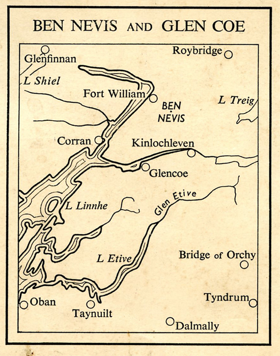
Part 7.  Glen Coe, Fort William and Glen Nevis, Kyle of Lochalsh and Kishorn.  East to Inverness.

Part 7 is dedicated to the memory of Fred, Kyle of Lochalsh warden, Willie, North Strome warden, Anne, Kishorn warden and Dave, Achnashellach warden, summer 1965.   If you’re still around do get in touch, or if you know of them, let me know.  Use the Leave A Reply facility at the bottom of this Chapter.  Thank you.

___________________________

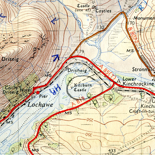
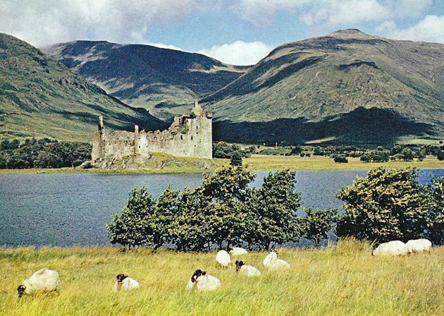
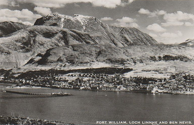
The Story So Far… Liking sooty Glasgow, mysterious MOD development near Garelochhead, Loch Lomond.  Frogs  at 3100′ in a peat pool by Beinn a’ Chroin and the Crianlarich hostel warden (at the old original hostel) with a sense of humour.  Loch Awe and Ben Cruachan before the dam and power station, (but nearly completed). Oban railway station before it was demolished, and on to Glencoe.

To Come  Walking Aonach Eagach. The Warden’s husband with a penchant for blokes.  A Tiger in his Tank at Fort William and at Glenelg an old woman with rags for shoes and a hat for a pixie.  Trouble brewing with the first Sabbath sailing to Kyleakin.  Four free-wheeling young wardens in the Kyle of Lochalsh and Kishorn area.  Fresh baked bread at Lochcarron.  A bumpy ride to Inverness.  Aviemore under construction and a Rank “Road Inn” at Loch Morlich.

Ratagan youth hostel and Loch Duich

__________________________

Glen Coe youth hostel, 1960s.

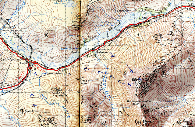
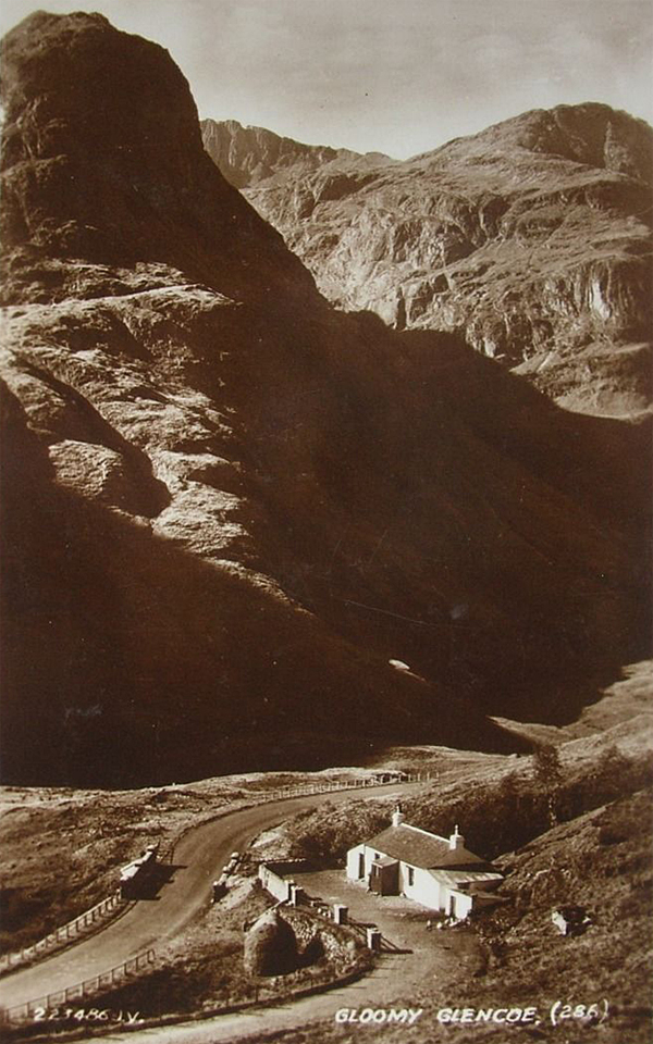
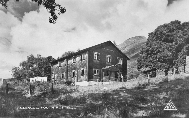
May 19.  Wednesday.  Around 9.30 a.m.  Glencoe hostel.

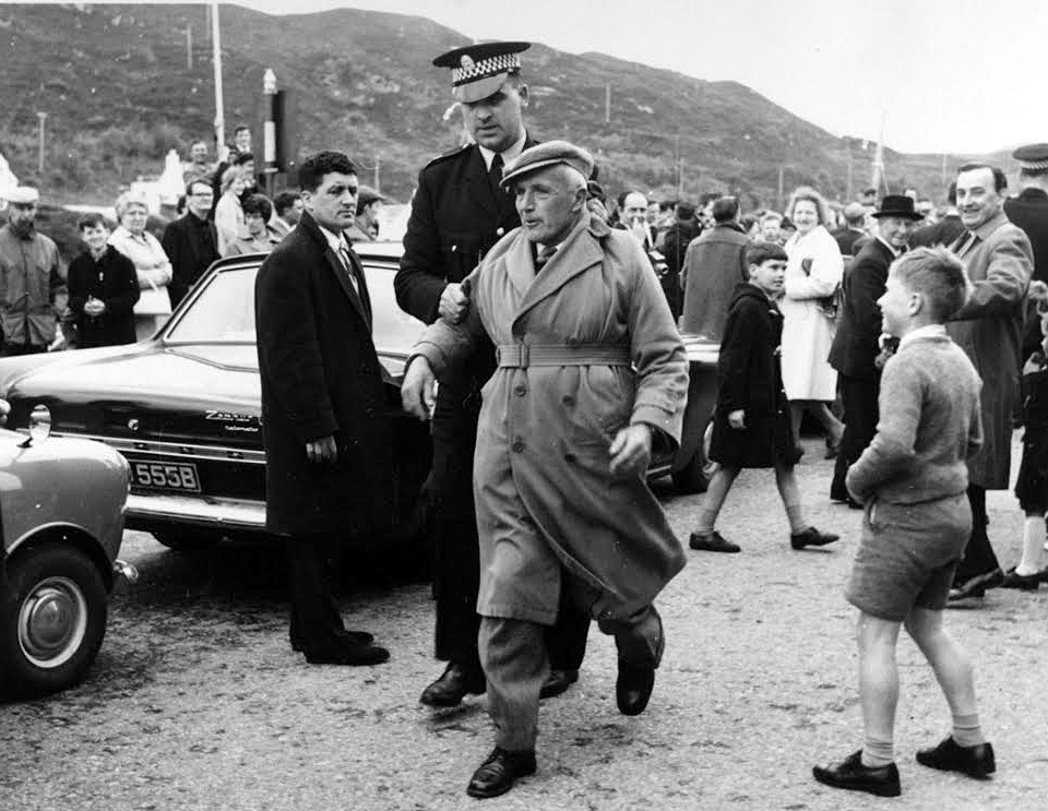
To finish off what happened last night.  I finished the paper work the warden had given me, but realised he wasn’t the warden after all, but the warden’s husband.  When I started on the paperwork he disappeared with the young bloke who’s staying here, to the pub, and then turns up later.  He says “Would you like to be the Assistant Warden” and drags me into their living quarters.  It’s coming up to 11 p.m.  His wife, the warden, is there and a sexy bird –  her daughter I think – plus a bearded walker and two other oldish blokes, all of whom I think are local.  They’re all drinking whisky and watching the Queen in Germany on the TV.

“This is Peter, he’d like to be Assistant Warden.”  “Hello Peter” says the warden who I think has a German accent.  “Go out to the wee shed and get yourself a bottle of beer”.  I do and return, sitting on a cushion on the floor.  It’s not too bad, as we sit there watching the TV.  I think the warden is interested in watching the TV as it is the first time the Queen has visited Germany.

The Queen HR Elizabeth 11 arrives at Bonn Airport on 17 May, 1965.   She is inspecting the Guard of Honour with the West German Federal Republic President Heinrich Lubke.   Prince Phillip is just out of picture to the right.  This is the first time a British monarch had been on a Royal visit since the Nazi era and the Second World War.

But within ten minutes the warden’s husband creates a scene – he’s pissed, making unpleasant remarks.  People pretend to ignore him but there’s an embarrassing atmosphere.  I excuse myself and leave. I didn’t need that.  It’s 11.30 p.m.  The electricity in the hostel itself is off, so find my way up the stairs to the dormitory in the dark.

This morning there’s a blue sky outside as I write this, just a few clouds, the Common Room windows are open and the air’s warm.  I’m about to set off for the Aonach Eagach.

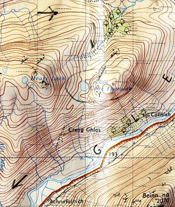
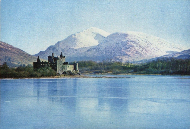
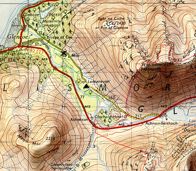
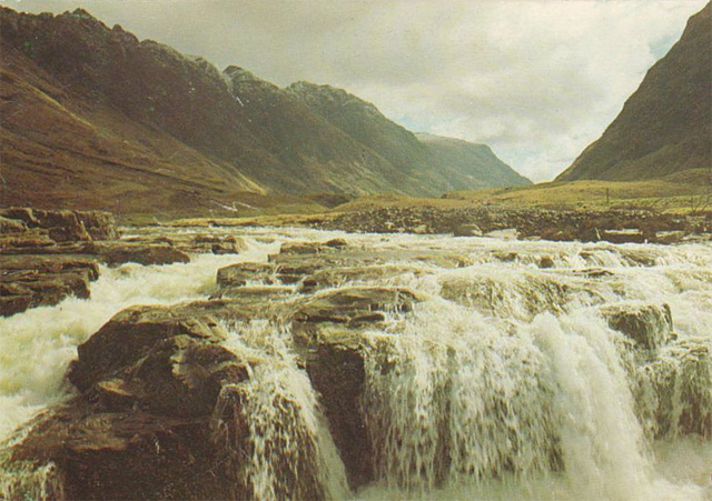
Am Bodach – on the ridge.  Left the hostel around 10.  Blue sky, some cloud.  Warm.  Walk along the road until joining the main road at Loch Achtriochtan, small loch at head of Glencoe Pass with the River Coe running into it, and several smaller streams.  Walk along and the Three Sisters really impressive, especially Aonach Dubh with layer after layer of crag going up, and trees on these crags and the grain seems to be running down to the valley.  Three big buttresses sticking out into Glen Coe.

The Three Sisters, Glen Coe.  Aonach Dubh on the right.

Walk along the road – some transport passes – until I come to Hamish MacInnes’s cottage – a delightful low white-washed cottage at the Meeting of the Three Waters.

Bridge of the Three Waters, Glen Coe.  1930s postcard.   In the 1960s the cottage was lived in by the climber Hamish MacInnes.
Meeting of  the Three Waters, Am Bodach and the Aonach Eagach, Glen Coe.

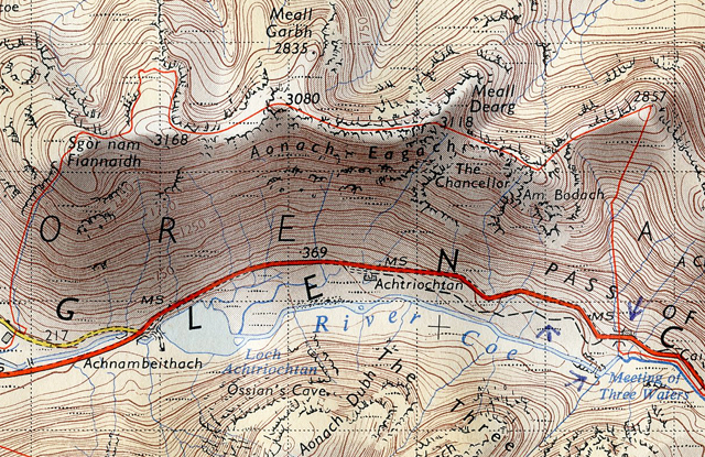
Eat a packet of Glen Garry biscuits and then take the path along, up the stream.  There’s a little electrical generator for the cottage, worked off a wheel with paddles that the water turns.  Ingenious.  So up the steep slope, keeping to the left of Am Bodach.  At Am Bodach, 3080′ there’s a view over to the north of Ben Nevis, still quite a lot of snow over there.

From Am Bodach it looks like a challenging walk along the ridge of Aonach Eagach.

The Aonach Eagach ridge, Glen Coe.

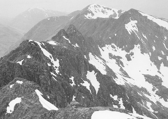
Glen Coe Hostel, evening.  Yes, from Am Bodach it was challenging walking along the Aonach Eagach.  It was more a mix of climb/scramble/walk.  At first it doesn’t seem as challenging as Striding Edge, but by Christ, it turns out doubly dangerous, and this is in good weather.  In bad weather it would be suicidal.  At places it’s a foot wide with sheer drops either side – and that’s no exaggeration.  At times the path comes up against solid rock, so it’s a case of crawling up, gripping on rock, luckily there are plenty of hand and foot holds.  Then at times it’s a case of carefully working your way down a gully.  The ridge is like spire after spire, so it’s not fast or easy going.  And fresh white snow sprinkled all over the place.  Soft to tread in.  Beautiful compared with the other old stuff.And on either side there’s more spires and pinnacles coming up and big, deep gullies going down.  Magnificent, but frightening.  On my left the Three Sisters and occasionally the valley and road below when you catch a glimpse of it between the pinnacles.  And on the right Ben Nevis all the time and Loch Leven.  After 3080′ it’s plain forward green grass  and wide ridge walking, and you see Loch Leven widening out into Loch Linnhe, and in the distance the sea.

Come to trig point at Sgor nam Fiannaidh which isn’t marked on the map.  Yes, there’s a lot of inaccuracies on this map.

Sgor nam Fiannaidh.   Acknowledgement Ordnance Survey One Inch Tourist Map Ben Nevis & Glen Coe, 1959 revision.

Built around the trig point is a round stone shelter and some bloke with a misplaced sense of humour has stuck a small Union Jack on the trig point – but I laughed.  I continue and all of a sudden I see Glencoe village and Ballachuillish.

Glencoe village and Ballachulish.  Acknowledgement Ordance Survey One Inch Tourist Map Ben Nevis & Glen Coe, 1959 revision.

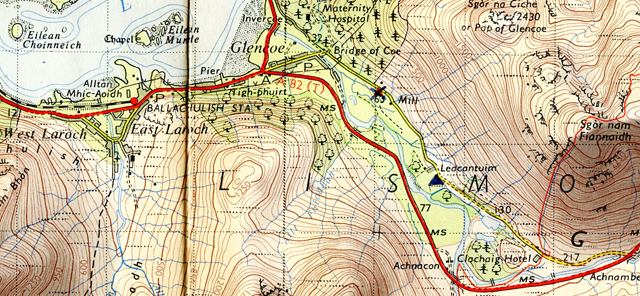
The street down there in Glencoe looks dead straight, with houses lining it, and the main road, looks all planned. And there’s a Sikh wearing a turban going door to door with a suitcase.  Probably a Betterware salesman. And the green valley flat, flat and fertile, and the Loch.  I can also see the hostel and the wood by it.  All very small, like a model.  I start the descent, but make a stupid mistake – the descent is steep with loose scree hidden by heather.  Treacherous.  Try going down a gully, but that’s too steep too, with rocks shifting under my feet so climb back up, swearing gently.  Walk further on and descend on the lower, greener slope –  running down it, a kind of exhilaration, and at the bottom come right out by the hostel.

Take my boots off outside and enter.  The warden’s husband’s there, and so begins the cat and mouse game – only I don’t know who’s the cat and who’s the mouse.  “Would you like some soup?”  “O.K.”  So I have some very peppery home made soup.  He’s lurking around.  Wash the bowl in the self-caterers.  “Come out for a drink, around 9, Peter?”  “No thanks.”  “Have you read Lawrence of Arabia?”  Makes a variation of the usual “Have you read Giovanni’s Room” approach.  (Giovanni’s Room by James Baldwin. In the UK in the 1960s the title of this book was used by many male homosexuals to test out the sexual orientation of other men.  The former Liberal Party leader Jeremy Thorpe used this approach.  T.E Lawrence wrote Seven Pillars of Wisdom.  Lawrence of Arabia, a biographical film of his life with Peter O’ Toole, directed by David Lean was made in 1962.)

No, I haven’t, I respond.  He tells me he was captured during the war and it shocked him to realise he was a masochist – (he pronounced it ‘machochist’).  And then “Did you go public school, Peter?”  Presumably he thinks all public school boys are queers.  And then I started remembering things from last night – he’d said his wife wanted a male assistant, yet later in their quarters she had said they had a girl assistant in mind. She will know what a young male assistant would be in for.  Hence a girl assistant.  He continues for a bit with me and I act cool throughout all this.  He’s not getting anywhere and takes the hint.  The pestering stops, and he makes some excuse about having to check something, and pushes off.

Make myself a meal.  Quite a few in tonight, including a couple of Scottish girls, a couple in their thirties, two English girls and a male Canadian and a bloke called Lou.  Around five to eleven the warden’s husband comes into the Common Room where we are and gets stupid – nasty.  “Lights out in two minutes, folks.”  One of the girls asks him where she can hang her washing and he says “Outside”.  “How can I get out there?”  “Through the door”, not smiling.  He follows us upstairs to the dormitory.  I’m brushing my teeth, he hangs around.  And before we’ve had a chance to get into our beds, he turns the light out.

____________________

May 2o.  Thursday.  Late morning.  In the valley of Allt Coire Gabhail.

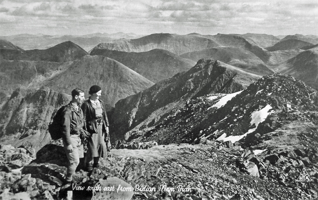
Leave the hostel about 9.30 a.m, along the road that leads to Meeting of Three Waters, until I leave it, taking the track from Achtriochtan which runs at a lower level.  The track follows the small gorge where the River Coe gurgles and rushes through.  It’s wooded and pleasant.  Cross by the bridge at the Meeting of the Three Waters to the other side and climb up, following the burn to Allt Coire Gabhail, otherwise called Hidden Valley and it’s really something.  Looking at the map you’d think just another V shaped grass sloped valley.  But no.  It’s a beautiful wide gorge going up to Bidean nam Bian 3766′.

Allt Coire Gabnail, Bidean nam Bien and Stob Coire.  Acknowledgement Ordnance Survey One Inch Tourist Map Ben Nevis and Glen Coe, 1959.

Cliff face on one side of Gearr Aunach and on the other side the wet dark cliff face of Beinn Fhada, water running off it.  But there’s more to it then that – the gorge is full of large slabs of rock, boulders AND trees, trees, trees, seemingly growing out of the stone. Beautiful delicate green fresh leaved trees – ash and sycamore – and then the scree and boulders and the sun’s so warm, the sky’s so blue.  As I made my way up following the stream I thought “Aha – pitch a tent here for sometime”.  And I may do if I get the job at Glasgow, and get a break for a week.  I’m writing this at the point where the stream emerges, comes pouring out like water from a tap, from the dry stone, boulder filled stream bed.

Bidean nam Bien, photographed in late June.

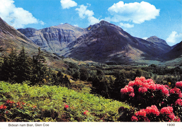
Hostel, night time.  The boulder filled stream bed was quite a scramble, and suddenly and dramatically it opens out into a flat valley, no trees, no boulders with Bidean nam Bian up there, and the flat valley looks like a big arena with three mountain sides, and the wooded valley I’ve just come up below.

Start climbing up the pass between Bidean nam Bien and Stob Coire.  It’s a steep climb through snow fields.  I’m surprised there is so much snow, it really is extensive, one hundred, two hundred yards up to the pass, where it hangs over, as if it were going to break off.  Slowly make my way up, digging my toes in – occasionally my foot goes right through, but it’s mostly alright. Make the pass.

View from Bidean nam Bien.  Circa 1930s/1940s postcard.

The other side is extensive scree, nothing but scree.  Descend, at times sliding with the scree that in places is the size of chippings.

Get down into the valley and a fairly easy descent along a sheep track to near the farm.  I think I can cross the River Coe, rather than go the long way round by the road to the hostel, but after trying to cross twice unsuccessfully I’m forced to go by the road.

River Coe.

Make myself a meal at the hostel.  A Scottish couple arrive, we talk.  Some other new people too, but not crowded.  One of the new blokes, and Lou who came last night have gone down the pub with the warden’s husband.  Lou seems to be his attraction for the moment.

________________________________

May 21.  Friday.  Glen Nevis Hostel.  9 p.m.

Glencoe to Kinlochleven and the Old Military Road to Fort William and on to Glen Nevis youth hostel.  Acknowledgement Esso Map No 7  Northern Scotland, 1962.

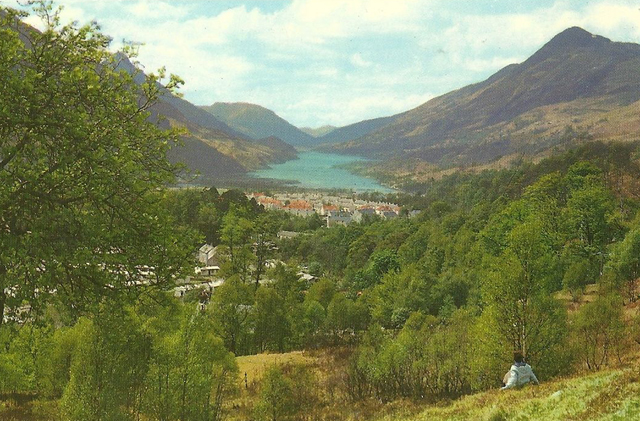
Walked along to Glencoe village from the hostel this morning and stand on the Kinglochleven road and hitch, but no go, so walk to Kinlochleven.  The road follows the loch, above it, looking down.

 Kinlochleven foreground and Loch Leven.  The road from Glencoe to Kinlochleven is on the left.

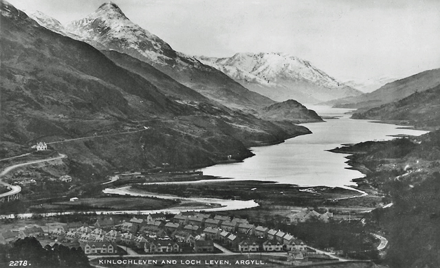
And down there at the head of the loch is Kinlochleven surrounded by mountains.  Orange roofs amongst green trees.

Kinlochleven at the head of Loch Leven.  “Orange roofs amongst green leaves.”

Kinlochleven is a pretty horrible 1930-ish development.  Unpleasant council looking houses, grey with green or orange/red roofs.  Probably developed with HEP (Hydro electric power)  pipe line that comes down the mountain side. (Kinlochleven was built earlier than the 1930s.  It was built when a hydro electric power scheme was built by the British Aluminium Company to power an aluminum smelter in 1907.  At its height British Aluminum Company employed 700 people at the smelter.  Kinlochleven was the first village in the world, in 1907, to have every house connected to an electricity supply.  The smelter closed in 1996, with subsequent loss of jobs. In his ignorance Le Patron did not realise that the grey external cement rendering over brickwork on most  twentieth century Scottish social and company housing was a necessity imposed by the adverse weather of Scotland – rain and frost in particular).

There’s the inevitable Co-op, but it’s closed, but there’s a grocers that’s open and I buy some food and matches and find out that it’s 1.45 p.m.  I ask about a bus in the grocers and am told there is one to Fort William at 20 past 6.  Outside I eat a packet of Fruit Shortcake biscuits and  decide to walk it, along the old Military Road.  A steep sweaty walk up the hillside out of Kinlochleven to the “road”.

The old Military Road from Kinlochleven to Fort William.  Acknowledgement Ordnance Survey One Inch Tourist Map Ben Nevis & Glen Coe, 1959 revision. 

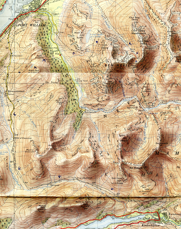
The Military road is murderous to walk along, pebbles, boulders, crushed rock.  Difficult under foot.  It follows the valley Allt na Lairige Moire.  Pass a couple of derelict farms.  Turn the corner and follow it down to Blau a’ Chaoruinn, a derelict cottage.

Blar a’ Chaoruninn, Blarmachfoldach and Glen Nevis youth hostel.  Acknowledgement Ordnance Survey One Inch Tourist Map Ben Nevis & Glen Coe, 1959 revision.

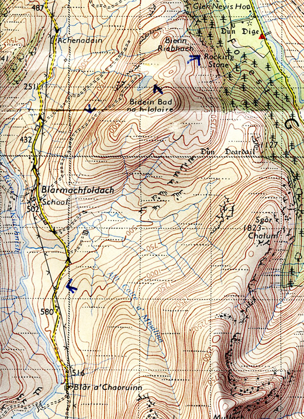
Grey/black clouds suddenly forming.  Along to Blarmachfoldach, now a properly made up road under foot.  Turn to the right, up a track to a small loch and by now it’s raining heavily, and descend down the hillside, through a very dense coniferous forest, until emerging out into a field and the hostel.  Hostel is fairly full with school parties and walkers.  There’s a youngish Australian bloke here and a Scottish couple, John and Betty, and the four of us natter away in the self-cookers..  I’ve just paused to write this up, whilst John has put the kettle on to make us all a cup of tea.

____________________________

May 22.  Saturday.  Glen Nevis hostel, evening.

Fort William and Ben Nevis.  Acknowledgement Ordnance Survey One Inch Tourist Map Ben Nevis & Glen Coe, 1959 revision.
Glen Nevis youth hostel.

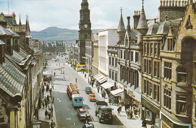
The day starts with a downcast, downcloud morning, and John and Betty – who’s attractive – and Barry the Australian and me walk down to Fort William.  Barry’s OK, great to listen to.  So we walk down to Fort William, the hills covered in white misty cloud.

Fort William and Ben Nevis on a sunny day.
Glen Nevis youth hostel (bottom right) to Fort William.  Acknowledgement Ordnance Survey One Inch Tourist Map Ben Nevis & Glen Coe, 1959 revision.
Fort William 1960s PC
Fort William, circa 1965.

We wander aimlessly around Fort William, looking in at shops, a Scottish crafts exhibition, 1/- admission (5p.).  Into a coffee bar.  Whilst we’re in there I nip out to buy a packet of biscuits.  First shop I go in there’s this girl assistant packing groceries into a cardboard box, taking no notice of me as I stand at the counter, and then goes into the back and that’s the last I see of her.  I say “Excuse me”, but no one comes out to serve me. “Anyone there?”  Still no-one comes out, no-one’s bothered, so saying “Sod it” I leave and buy 3 packets of biscuits in another shop.

Go back to the coffee bar, but it’s a curious place – not really a coffee bar – two old women in a small space pouring out miserable cups of 6d. tea.  We’re sitting by the window, looking out onto the street.  We haven’t got much to say, place is depressing.  Finish the tea, leave and into a pub for a pint.  First pint I’ve had in Scotland and it tastes sweet.  (Scottish beer – “heavy”  – is not hoppy like English bitter.)  Barry talks and he’s entertaining to listen to, beautiful soft Australian accent and makes Australia sound interesting.

Mostly locals in the pub.  Old blokes drunk, arguing amongst each other about nothing.  Some very drunk.  One bloke concentrating on slowly picking his pint up, and trying to match the glass to his mouth without pouring it down his neck.

We emerge and go into the museum – another 1/-, not that good, and after shuffling round it, emerge, slowly starting to make our way back.  Pause to watch a shinty match.  Hockey for men, sticks swinging high, looks dangerous.

So wander back to the hostel.  Alan joins us, who was there last night, a Scottish bloke who’s a laugh with his yellow cape and “I’ve Got a Tiger in My Tank” sticker on the back, as we walk down the glen back to the hostel.  (“I’ve Got a Tiger in My Tank” were stickers that many motorists stuck on the rear window of their car.  They were part of a promotion campaign by Esso.)

Esso: Put a Tiger in Your Tank.  1960s promotion campaign.

I cook my tea, but made too much spaghetti and put too much water in the tomato sauce. However.  Never mind.  We’re sitting around afterwards at a table in the self cookers and a Chinese/American turns up from California, who Barry says he met in Glasgow a couple of days back.

Later in the evening we decide to go back to Fort William for a drink, and I went with them as I was bored.  Try to find a quiet pub, going from pub to pub, and Alan’s caught up with us, still wearing his cape, with two bloody awful girls he met in the hostel.  And as Barry says “What are we doing?”  Yea, what are we doing, so I turn around and start to walk back to the hostel with a mate of Alan’s.  We buy some chips from a mobile fish and chip van.  Plenty of local drunks around.  Half way down the glen road we get a lift and the driver drops us off at the hostel.

And a phoney bloke – a con man – who we’d seen in Fort William earlier in the day seems to be staying the night. Well, he’s hanging around the hostel.  He dresses up as a sort of Bonny Prince Charlie, kilt, berry, feather, the whole works like something out a Walt Disney film.  He was charging tourists money to let them take photos of himself.  And he’s English.

______________________________

May 23.  Sunday.  Glen Nevis YH.  Evening.

Today it was overcast and occasionally it rained.  After breakfast eleven of us set off to the waterfall at Steall.  Myself, Barry, John, Betty, Tom – the Chinese Yank – Alan, Ian his mate and four girls who remained nameless but two of them were worth looking at.  Along the road to Achriabhach.

Achriabhach, Water of Nevis, Steall waterfall and Steall cottage.  Acknowledgement Ordnance Survey One Inch Tourist Map Ben Nevis & Glen Coe, 1959 revision.

Where the road finishes there’s a coach parked and lots of tourist cars.  Cross the bridge, now on the track.

Water of Nevis, Glen Nevis. 1930s postcard.

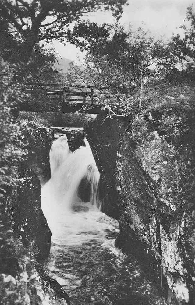
Onwards.  Mountains towering either side and a mountain in front so that it looks like a cul-de-sac.  The track ends and it’s now a footpath that runs into the gorge, the River Ness frothing through it.  Me and Barry ahead, Barry taking the rucksack. Along the path and the gorge opens out into a valley and there’s the waterfall, falling down the mountain side.

Steall Waterfall, Upper Glen Nevis.  Photo and Acknowledgement Geological Survey and Museum, London.

And Steall Cottage.  A tent is pitched by the wire bridge that spans the river.  Go over the bridge –  swinging around – V – that’s how it looked – one wire to walk on, two to hold.  Barry and me work our way across OK.  The cottage is locked and belongs to some climbing group.  Eventually the others catch up, crossing the wire bridge OK too, and we sit in the woodshed attached to the cottage.  Alan’s primus stove going and my coffee, as no-one – who? – remembered to bring any tea.  We had five cups – enamel cups – that we took it in turns to drink out of.  Eventually we all leave and Alan and I return by the other path, on the other side of the river only when you come to the gorge you’re amongst the boulders and rushing water, so we climb up and over the hill, rejoin the path, continue, cross the river, join the other path and catch up with the others.  Barry’s talking to the Swiss girl and her father, who turned up at the hostel last night. As we walk along the road a RAF Mountain Rescue Landrover picks us up and drops us off at the hostel.  I spend most of the night talking to two warped Catholic girls.

I don’t feel like writing anymore at the moment.  Could write a lot more but won’t.

____________________

May 24.  Monday.  On the path to Ben Nevis.

Glen Nevis youth hostel to Ben Nevis cliffs.     Acknowledgement Ordnance Survey One Inch Tourist Map Ben Nevis and Glen Coe, 1959 revision.

Up 8, left 11.  In between had breakfast, collected food people didn’t want, said goodbye to Barry as he left with his heavy rucksack.  Yea, nice bloke.  The Chinese Yank left too, after doing his job.  When asking the warden what his hostel job was he said “Sir”, which I’ve notice all Americans say.   Hung around until John and Betty left, said goodbye.  And then set off, crossing the bridge over the Ness Water, up the slope and along the path for Ben Nevis summit.  And at the moment, sitting here, writing this I feel I’m just standing still.  I can’t define how I feel.  I’m just not using up my energy. Felt it very strongly at breakfast. I’m drifting and I’m fed up.  I want to write.  One thing I want to work into a play is the way when you’re listening to someone you look at his girlfriend and she looks at you and he doesn’t notice.  It’s a nice touch.

There’s four girls coming up the slope towards me, as I’m writing, and there’s one in tight black tights and tight red jumper that I’d like to screw.  However, that’s not going to happen, is it.  Cloud again, like yesterday – mist and low cloud on Ben Nevis, so there’s no point in going to the summit. Totally pointless – I won’t see anything and I’ll get wet.  Snow capped peaks behind me.  Overlooking Lochan Meall an t-Suidhe –  a loch perched, or rather, in the saddle between Meall an Suidhe and Carn Dearg.  Sweaty walk up to here, boulder pebble path, pass an oldish couple, me still feeling useless, bit of blue sky now, but it won’t last.

Ben Nevis “cliffs” on the north east side of Ben Nevis.

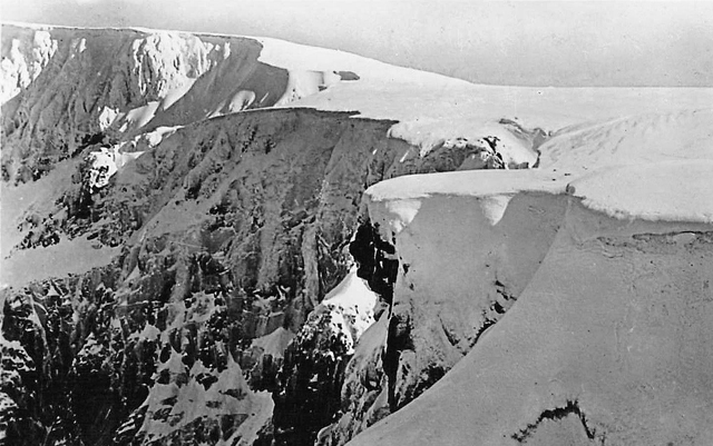
Hostel, evening.    So, I continue round to the cliffs, although you can’t see them to their full height as low cloud was swirling around, rather interesting and terrifying.  Jagged, rising up, like fairy tale mountains in a cartoon Walt Disney – mountains where wicked witches live in castles.  The mist’s swirling around and small streams are running down the face and disintegrating into spray with the fierce wind.  There’s a mountain hut for climbers.  Go past it, smoke a cig, return.  It’s now pissing down and I’m getting wet.  Walk back and down to the hostel.

The Bonnie Prince Charlie con man is hanging around again this evening. He’s talking phoney nonsense to anyone who will listen, but most can see through him.

________________

May 25.  Tuesday.  Near Ratagan YH.  3.15 p.m.

Yes, near Skye – great luck.  But first the story.  It’s sunny and close when I leave the hostel this morning and walk along the road towards Fort William.  Last half mile into Fort William I’m accompanied by one of those insufferable “guess where I’m from” blokes.  A very boring bloke from Rotterdam who’s telling me how he spent 25 days in Edinburgh waiting for his passport.

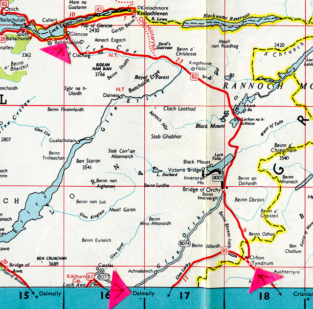
Fort William – that none too pleasant town and turn right and walk along the Inverness road until I get past the turn off for Corpach.  I stand just past a filling station and the “Ben Nevis” distillery opposite, and the British Aluminum factory up the road.  The leaves on the trees are very green, and there’s something about where I’m standing that reminds me of the Continent – reminiscent of times spent by roadsides waiting for lifts.  And I wait a long time.  Most traffic turns off for Corpach – big pulp mill there – and I reckon any lift I get will be going towards Inverness.  Hitch, smoke, watch a lorry get loaded with barrels of whisky and then driven to the store sheds just down the road and back again, and gravel lorries and contractor’s lorries – “Logan” – going backwards and forwards.  They’re widening the bridge into Corpach.  So I’m standing there thinking “Where the hell am I going to be tonight – Will I have to get a bus or train?”   But they’re so infrequent – MacBrayne’s Royal Mail Highland buses – but Mini stops. Young bloke with little wispy Edwardian moustache, tweed jacket, old school tie, trousers, socks up to knees and shoes.  From Berwick upon Tweed.  Smoking Silk Cut and, AND he’s going to Kyle.  Real luck – and off we go.

Fort William – Invergarry – Shiel Bridge – Ratagan.  Acknowledgement Esso Map No.7 Northern Scotland, 1962.

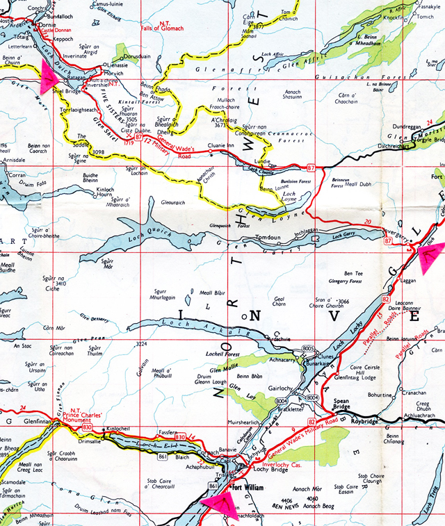
Along Loch Lochy to Invergarry Hotel and turn off left for Skye, driving along Loch Garry, Loch Loyne and Loch Cluanie.  Good scenery – getting wild, barren, rocky around Loch Cluanie, the road becoming single track with passing places.  Stop at an Inn which has a complete monopoly on this stretch of road – hence 7/- (35p.) for 8 small cheese and ham sandwiches, and I mean small, really tiddly.  7/-.  Fucking robbery, only I wasn’t paying.  I bought two Mackeson’s – 4/- no draught.  Another oldish couple in the place. Edward Gardner, Conservative, Round Table sort, and his wife.  (Edward Gardner, Conservative MP for Billericay, Essex 1959 – 1966.)

Kintail Mountains from Shiel Bridge.    Early Spring view.

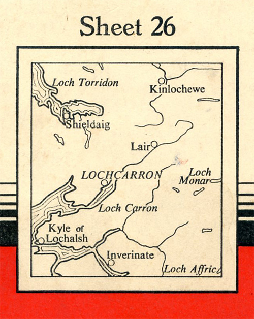
They leave and we leave.  Driving along a rough, unmade road – it’s rough as it is being widened, with Ed. Gardner and wife in front in a Rover.  I get dropped at Spiel Bridge and again, luck of luck, there’s a petrol station, cafe and store and manage to get OS 26. (OS Map 26: Locharron.)  So I’m all set.

One Inch Seventh Series Ordnance Survey Sheet 26 Lochcarron. Published 1957.  Minor Revisions 1961.
Area covered by Ordnance Survey One Inch Map 26 Lochcarron.

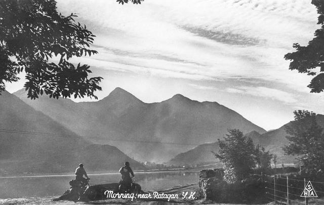
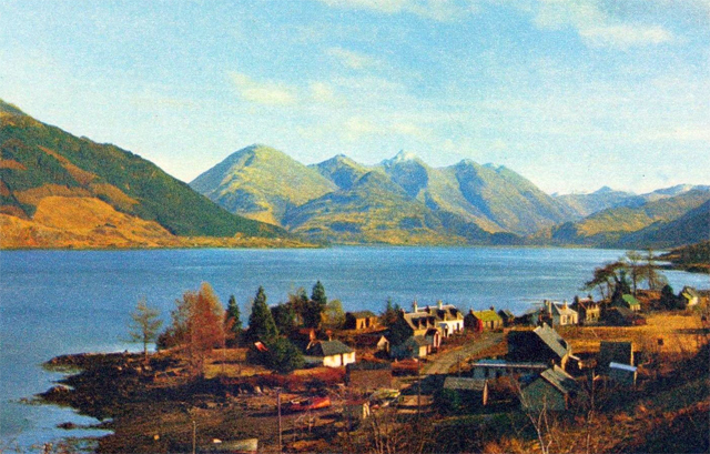
Ratagan YH around 8.30 pm.  The hostel’s bang on the shore of Loch Duich.

Ratagan youth hostel, Inverness-shire.
Ratagan youth hostel and Loch Duich.

I’m sitting in the common room cum kitchen, small friendly, little window directly in front of me with the loch and the opposite hills.  Beautiful, but the place is spoilt by some insufferable inmates.  A sun-tanned Englishman with a moustache – looks like a 1928 colonial tea planter – who drove me up the wall making a foul noise eating his meal, slurp, slurp, and two cyclists, a male and female (in electric green glasses) plus the warden, all talking shit, passing bitchy comments.  Feel like mowing the lot down.  But if I had the place to myself, if it was quiet in here, it’d be as good as Nant-y-Dernol.   The men’s dorm is a warm attic in good repair.  It’d be a beautiful place to live in.

The view from Ratagan.

As I walked by the side of the loch to the hostel from Spiel Bridge there was a strong smell of salt in the air – it’s a sea loch, seaweed on the shore.  Instead of being in the hostel with this lot it would be nice to sitting in a tent by the lochside, and have a scooter.  Be really independent.  If I get the job at Glasgow I’ll probably buy a scooter.

_________________________________

May 26.  Wednesday. Glenelg YH.  Evening.

Before I set off for Glenelg this morning I left my rucksack at Ratagan and walked back to Shiel Bridge to get some more provisions.  The 1928 English tea planter accompanied me as he was returning eggs he had bought there, which he said they were “Off”.

Low cloud on the hills but lovely day and the Loch very, very still, and again the strong smell of salt in the air. Plus the coconut smell of the yellow gorse in bloom.  The coconut cake pointy hills opposite.  One has a forest on its lower slopes and the rest is bare – looks as if it’s had a shave.  Provisions bought I return to YH, pack them into my rucksack, have a pee in the Gents at the back of the building and set off along the little road that follows the loch.

Letterfearn, Tataig, Eilean Donnan and Ardintoul.  Acknowledgement Ordnance Survey One Inch Seventh Series Map 26 Lochcarron, 1961 revision.

Nice little road, grass growing in the middle of it.  And yellow gorse bushes growing everywhere, and long grass and bluebells and nettles and primroses.  Lettterfearn is the hamlet along this road.  A collection of small cottages and a school with about five kids playing football with a red plastic ball. (The school is now closed.)

“Children at Letterfearn”. 1898.  Reproduction postcard.  Original source/photographer unidentified.

A lot of the cottages have tin sheet roofing.  There’s rowing boats on the shore.  It’s nice.

Letterfearn, circa 1910.   A Valentine’s of Dundee postcard.
Letterfearn, Loch Duich.  Autumn photo, 1960s.

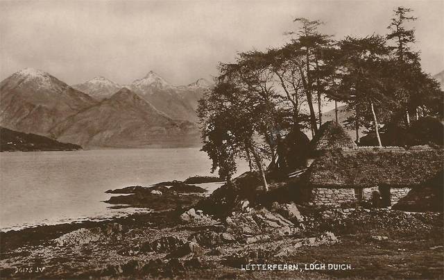
Walk on to where the ferry once operated  from a cottage with a slipway called Totaig across to Eilean Donnan.  Eat a packet of Rich Abernethy biscuits, drag on a cig.  Walk on.  The road, as such, ends here and from now onwards it’s a footpath.   It goes into a Forestry Commission area, only it’s not regulated coniferous trees, but a glade and there’s a cove down there with three white boats, no one around.  Peaceful.  Continue on the foot path to Ardintoul.

Ardintoul and Ardintoul Bay.   Acknowledgement Ordnance Survey One Inch Map 26 Lochcarron, revision 1961.

Ardintoul is an interesting place.  You look down on it from the footpath, a small peninsula, if you can call it that, nestling amongst the hills.  It’s flat with very green fields, about five at the most.  Drives of trees and a few cottages and one big Georgian farm house.  What’s interesting is that it is completely cut off.  No road or track to it.  Just this footpath.  There’s a tractor down there, so they must use a boat to bring stuff in.  Cross Allt na Dalach and sit on the remains of a cottage.  Go down passing an empty cottage, with a red oxide paint tin roof,  along a drive of trees and then along a stone wall by the shore.  Past a second empty cottage and past the big inhabited farmhouse, bottles of butane gas out on the verandah and a friendly  black sheep dog accompanying me.  (The “farmhouse” was built in the 1700s by the MacRae family about the time of the destruction of their hereditary stronghold Eilean Donnan Castle across the water.  The farmhouse building was destroyed by fire August, 2012.  It was uninhabited at the time.)

And between the farmhouse and the shore there’s two big gas looking cylinders – like you see at a gas works, one built of bricks and there’s military fencing around them.  Interesting.  (They were oil storage containers built by the Royal Navy during the Second World War.  They were decommissioned a while ago.  There is little now to indicate that they were once there.)

Continue to another cottage and a byre for tractors.  Plenty of sheep and lambs around.  Skye is directly ahead of me, go round Garbhan Cosach, the headland, and walk along the shore of the channel  between the mainland and Skye.

Ardintoul to Glenelg youth hostel, Glenelg to Kylerhea ferry, coast walk to Kyleakin and ferry crossing to Kyle of Lochalsh.  Acknowledgement Ordnance Survey One Inch Map 26 Lochcarron, 1961 revision.

Climb up the hill.  See the ferry and the slipway.  Not many cars.  (The Ordnance Survey One Inch Map 26 Locharron, “Reprinted with  minor changes 1961” shows the Kylerhea – Glenelg ferry as foot passengers only.  It also shows a track from the Kylerhea slipway, rather than a made-up road.  In 1965 the Kylerhea track was tar-macamed and the ferry vessel could take approx. four vehicles.)

Walk to the hostel.  Dr. Johnson is reputed to have stayed in it when it was a cottage.  It’s locked, so wait around as I’m not sure about the time.  Watch a Ford Anglia turn up at the ferry, then change its mind and go back, and then a GB Mercedes turns up.  Hear the door of the hostel/cottage being unlocked and enter.  Old couple, bloke looks like a fisherman.  Friendly.  Have the place to myself.  Have a reasonable meal and I’m writing this sitting at a long table by the window of the Common Room, which has one of those old iron ranges that nearly all these small SYHA’s seem to have. From the window I have a view of the straights, Skye and over there the hamlet of Kylerhea.  All the cottages are white-washed and spaced out and the fields are open and unfenced.  Looks foreign. Unusual. Pleasant.

____________________________

May 27.  Thursday.  On a bench outside Kyle (Lochalsh).

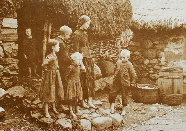
Made myself breakfast of porridge, Quick Quaker Oats, instead of the usual Crofter or Scots oats, cup of coffee with diluted evaporated milk and away after warden’s wife gave me my card.  She’s a funny little woman, wearing a peculiar sort of pixie hat and on her feet what looked like two rags tied at the ankles.

“Isabella MacDonald, travelling tinsmith, Glenelg.” 1889.  Reproduction postcard.  Original source/photographer unidentified.

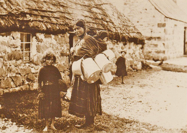
(In the above photo of Isabella MacDonald at Glenelg her children are barefoot.  The baby on her back is approximately one year old.  In 1965 that baby would be 76 years old.  Would she be wearing rags on her feet?)

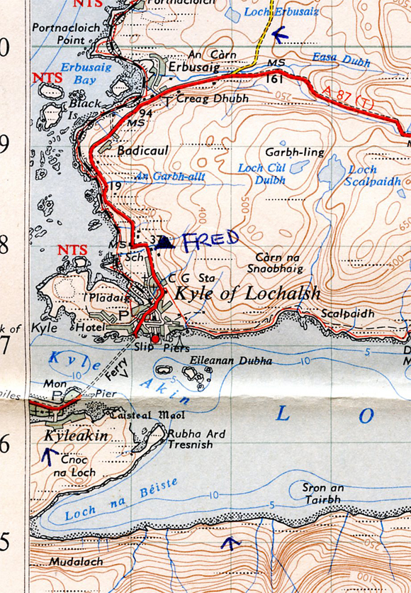
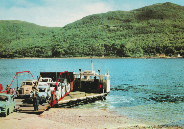
Wait by the slip, smoke a cig –  the ferry’s at Kylerheah.  Ferry comes across, car goes on, then me.  Ingenious thing.  It’s a revolving turntable on the boat.  Boat comes up by the side of the slipway and then swings the turntable onto the slipway,  the ramp is let down and away you go.  So across I go, for 6d. (2½p.)

Glenelg-Kylerhea ferry. 1960s.

Land on the other side, on Skye, and turn right and scramble along the hill-slope until finding the path.  So along it, passing the small lighthouse and after that the path flakes out, despite it being marked on the map.  So it’s up to your initiative.  Until you round the headland it’s not too bad.  But after that it’s bloody murder underfoot.  You wouldn’t know from looking at the map – there’s trees, fern, bracken, heather, rocks, boggy spots, everything to make it uncomfortable underfoot, stumbling from one spot to the other.  There’s a wreck down there, sticking out of the water and on the shore some blokes dismantling a large piece of it.  Rusted brown metal.  Looks like a frigate.

Stumble, stumble on, at times descending and walking along the shore, and then having to ascend where it gets impossibly rocky and sea’s lapping up against the rocks. And so it continues until I descend to the cove Loch na Beiste and I’m glad to reach the head of it, and then have to climb out of it and  – ah moorland!  I stride across it, soggy, squelchy, until after this murderous walk the beautiful sight of Kyleakin down there – shops, and the ferry.

Car ferry, Kyleakin. Late 1950s/Early 1960s.

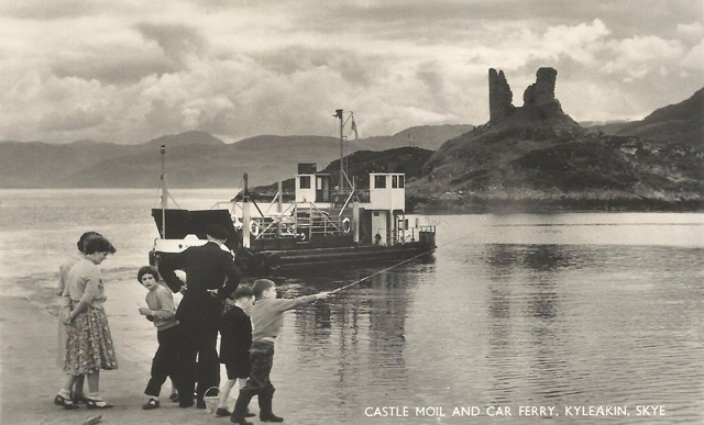
Descend down into it, ducking underneath a washing line with washing on it.  Cottages that back into the hill slope. I’m hungry.  Go into a shop that has “General Stores”  written on the outside but just sells paint.  Go into another shop near the slipway and buy food, including a packet of rich tea biscuits and a date bar.  Eat the biscuits by a wall, seagulls flying around.  Packet half eaten get on the ferry and over to Kyle.  Landed and ho-ho, what do I find – most of the shops are open.  SYHA handbook says Thursdays are their half-closing day.  Stuff is cheaper, like eggs. Oh well.

The Kyleakin (Skye) ferry arriving at Kyle of Lochalsh. A Post Office van waits for the mail bags. 1960s.

Buy some more food and find out it’s 3 and trot out of the town and sit on a bench near the old, tin roofed Victorian school which is the hostel – which looks ghastly from the outside. Iron railings and dead looking.

“Kyle of Lochalsh – Gateway to Skye”.  1960s postcard.

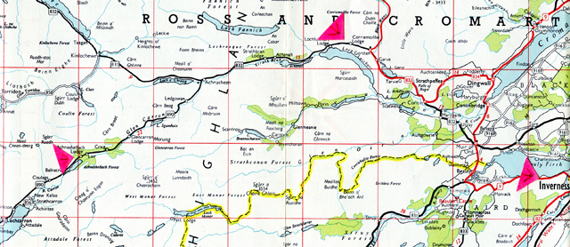
Kyle YH. Evening.  The hostel is better on the inside.  Whilst I was waiting asked a passing woman with a young child the time.  She said she thought it was four.  Go up and try the door, and it’s open.  Met by a zooty young cockney warden with ginger hair, beautiful white teeth, and friendly.  Keen cyclist/hosteller and a good bloke.  He’s called Fred.  Older woman cyclist turns up, who when she started talking went on and on and on but she was OK.  Later, around 8 p.m. a Belfast college bloke comes in.  A good evening.  Fred the warden, the woman cyclist and me talking, having a laugh.  Fred’s been wardening 3 years in Scotland – during the summer.  North Strome last summer.  A real cockney from Hackney and active with the Central London YH group.

______________________

May 28.  Friday.  Kishorn YH.

Wake up at Kyle YH and it’s a good day outside and the Cuillins looking clear, seem to rise up out of the sea.  It’s a promising day. As I was packing my rucksck to leave a couple from the SYHA turned up.  They seem to go round checking things are OK with the wardens at the smaller hostels around here.  Fred was talking to them as I leave at 10.30  – gives me a wink – and start what turned out to be one of the best walks I’ve done for a long time.

Kyle of Lochalsh – Plockton – Strome Ferry – Kishorn youth hostel.   Acknowledgement Ordnance Survey One Inch Seventh Series Map 26 Lochcarron, 1961 revision. 

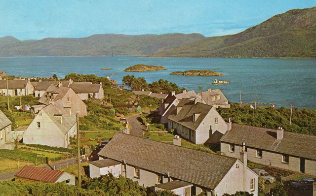
Trot along the main road, the sea out there, the air warm and I’m already feeling good. Hardly any traffic.  A view of Skye and small islands.  The single track railway, the yellow gorse bushes, the telegraph poles and hummocks and hillocks.  Turn off onto the minor road to Drumbuie and Duirinish.  Beautiful road.  Drumbuie is a collection of crofts, off the road to the left.  Most have tin sheet roofing, presumably replacing heather thatch, or nailed on top of old thatch.  The cottages are in a general area, no road between them, just together with chickens running around, scratching in the dust.  Cows grazing, sheep, and its flat down to the sea – open fields, no fencing.  Strip cultivation – one strip ploughed, another for grazing, another fallow.

Kyle of Lochalsh – Drumbuie – Duiriness – Plockton. Acknowledgement Ordnance Survey One Inch Seventh Series Map 26 Lochcarron, 1961 revision.

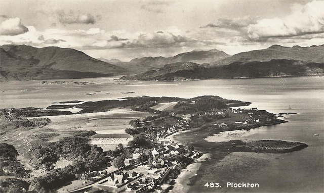
Continue along road and come into Duirinish and coming into it there’s several leafy big beech trees and a farm, farm implements.  Cottages on either side of the stream which runs through the village and cottages lazily arranged, strung along the road.  A couple of young children playing, an old man, the sun’s out, quiet and warm.  Over the bridge and take the minor road   through a wood that eventually runs by Loch Lundie.  There’s a beautiful smell of greenery in the wood and the loch’s beautiful and distinctive.  Further on, on my left is a view looking over to Plockton, cottages along the coastline, whitewashed cottages, sea looking beautiful, and the shore of Loch Carron over in the distance.

Plockton, Ross and Cromarty.

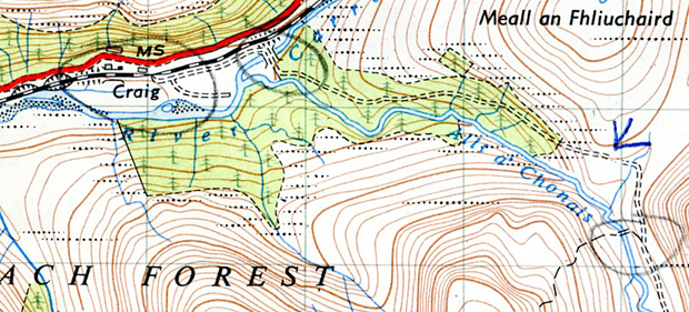
Walk on to Craig, a couple of cottages and then along what must be the most beautiful stretch of coast in the British Isles – the sea below you, the single track railway line and cliffs above you.  The warm air is heavy with the scent of the yellow gorse and there are crimson/red flowering wild rhododendron and trees and long lush grass, the islands in the distance and the sun on an intensely blue sea.

Craig – Achmore – Stromeferry – Kishorn.   Acknowledgement Ordanace Survey One  Inch Seventh Series Map 26 Lochcarron, 1961 revision.

Further on pass a derelict cottage just off the track.  Go and look at it.  By a stream, beautifully situated with this wonderful view.  Gorse bushes and sheep grazing by it.  Inside it’s in good condition, although the farmers let his sheep in.  There’s the old range, and I hang around, dreaming.  I’d like to live here, work the land.  But oh well, and on I go, joining the A890 – small road, little traffic, through Achmore – a recent Forestry Commission village.  Not too pleasant as the houses are, or look like, post war council type houses except built with wood.

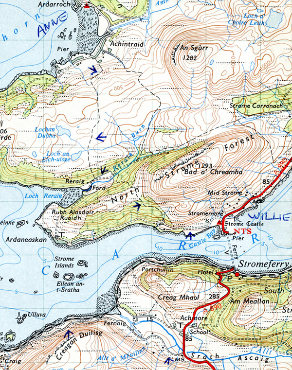
Out of Achmore and up the hill, over the hump and down to Strome Ferry.  Post Office on the station and by the ferry a small kiosk selling sweets.  Buy some chocolate and go across on the ferry for nothing.

Strome Ferry. 1960s.

It’s warm, the water is deep and inviting.  Land on the other side, and off again, noticing the SYHA couple are now at the Strome hostel talking to I presume the warden, who looks young.

Follow the coast and take the footpath through a wood, up the slope, and then a steepish descent to Reraig.  There’s a new house being built by the edge of the cove.  Cross the stream and up and over the next slope, and from the brow there’s a fantastically beautiful view of mountains rising vertically out of nothing on the other side of the loch.

Applecross Mountains from Kishorn.  1970s.

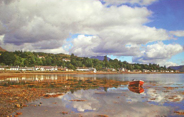
Descend into Ardarroch, white-wash houses on the shore, pass a couple of old blokes, afternoon, afternoon, lovely weather, aye.  Round the bay to Kishorn hostel – it’s an old school.  Dump my rucksack and try and find the shop.  Ask two small boys, they direct me, find it and it’s a great shop – buy bread, milk, spuds, everything I need and return to the hostel.  Enter and in the small kitchen there’s litter strewn over the floor.  Apparently some dog got in and had a field day with the litter bin.  Clear it up.

Loch Kishorn, Ross & Cromarty. 1965.

The warden rolls up on her Lambretta.  Young girl, can’t be much more than twenty, pretty, with a nice disregard for her appearance.  A shy, retiring Tom Boy and she’s nice – wearing a worn, torn pair of climbing breeches and a pair of broken plimsoles.  Her name’s Anne.  The SYHA couple roll up, the bloke mends the door the dog got in by, ask if everything’s going alright and they push off.  Me and Anne spend most of the evening talking.  She does temporary work in the winter – typewriting.  She told me that when she started as the warden at Kishorn, on her first week-end on the Sunday she started her Lambretta up and rode out of the village.  On the Monday she got told off by a couple of villagers  for starting her Lambretta up on the “Sabbath”.  So she now wheels it out of sight and out of sound on a Sunday, and then starts it up.  Also told me that there is expected to be a demonstration this coming Sunday at Kyleakin as the ferry is going to run from Kyle, the first time it has ever done this on the Sabbath.  And so to bed at 11.30.  Just me in the place tonight.  Good, good day.  Good hostel, beautiful place

__________________________

May 29.  Saturday.  Sitting on a bench by the hostel, 4.30 p.m.

It’s been a glorious day – the weather, the superb scenery – Sguur a Chaorachain, Meall Gorm and Beinn Bhan rising up as I write this.

Beinn Bhan 2936′, from Loch Kishorn.  Photographed when there was a dusting of snow.  Autumn or Spring.

The weather was beautiful when I set off this morning – still is.  Along the B857 road – but just a country road, has the feel of an unclassified road.  Through an avenue of trees and out by the small estuary.  Tide out, walk along, turn off to the left at the head of the estuary and then up the hill-slope.

Kishorn youth hostel to Beinn Bhan 2936′ and back.  Acknowledgement Ordnance Survey One Inch Seventh Series Map 26 Lochcarron, 1961 revision.

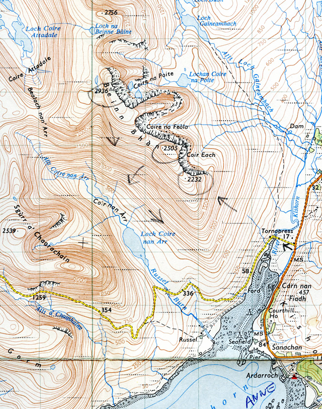
Pause to finish off my notes for Friday, long pause.  No need to rush.  Taking it all in.  A tractor ploughing at the head of the loch, the sea, the sun and a car parked down there.  So a gradually climb up the slope of Beinn Bhan until reaching the 2232′ point.  Sgurr a Chaorachain over there, looking impressive.  Flattish on the shoulder of Beinn Bhan as I walk along to the 2505′ point, having taken off my sweater, stripped to the waist, as it’s getting hot. Say hello to some blokes sunbathing at the 2505′ point.  Ask them the time – it’s 1.30.  Continue making for the trig point, 2936′.  The cliff face to my right that juts out is quite something.  Wouldn’t like to be up here in mist and take a wrong turn. Opposite Sgurr a Chaorrachain, a great buttress sticking out, casting a shadow over the hillside opposite.

From the trig point I start to descend, a long steep descent, a herd of deer below me.  When I get to the 500′ contour line, or thereabouts, it’s easier and I follow it, walking along, above Loch Coir nan Arr and eventually down to the unclassified road.  Cross the estuary – the tide’s out, walking across firm sand.  Sea weed and pools, and back onto the B road.  Walk along to the P.O. looking forward to a meal of bread, tomatoes and cheese – but no bread, so bang goes that.  Walk down to the hostel and on the way meet the woman cyclist who was at Kyle – she’s going to Achnashellach.  We spend five minutes talking.

Dump my rucksack outside the hostel and sit on the rocks.  Anne turns up and joins me.  We sit in the sun talking, and go inside when it starts to get chilly.  Have a meal of Chow Mein followed by tinned apricots and rice.  Afterwards me and Anne spend the evening talking and around 10.30 p.m. young bloke comes in and I recognise him from North Strome – it’s the warden there, Willie is his name.  He’s half cut and a laugh.  Been drinking in Kyle and decided to come over and see Anne as he reckons she’s lonely, he says.  She just smiles.  I think he’s got other designs, but he’s so half cut it would take him half an hour to get his flies undone, by which time, even if she had been interested, she’d have lost interest.  He takes ten minutes to roll a cig.  The surprising thing is that he’s 28, doesn’t look it, looks more Anne’s and my age.  He finally finishes rolling his cig. “There”, he says “Cary Grant couldn’t have done better.”  I give him a light as he can’t find his matches.    We go on talking – it’s mostly him who goes on talking, telling us about a bloke who climbed one of the Swiss Alps wearing plimsoles.

It’s quarter past midnight and we go to bed – Willie and me to the mens dorm.  He’s forgotten why he came in the first place.  He still talks in the darkness of the dorm as we lie in our bunks.  Turns out he’s a Communist, so we have a general argument as he doesn’t think much of anarchism and I’m not a fan of the CP (Communist Party), and then we get onto literature and Gorki and Chekhov.  He works at labouring over the winter and blows the lot.  He’s broke at the moment.  I roll him, and me a cig.  It’s two in the morning – I know the time as he’s got a watch, and as I’m smoking it I’m starting to feel peculiar.  Soon afterwards I’m sick three times and crap twice.  I’m ill – probably sunstroke.  Willie is deep asleep.

___________________

May 30th.  Sunday.  Next morning.

I’m still groggy when I wake up.  Willie’s bunk is empty.  Put some clothes on.  Anne is cooking Willie a meal of bacon, fresh tomatoes, bread and butter.  She says there’s enough for me too, but all I can mange is a cup of tea.  Willie asks what’s wrong with me. I shake my head and go back to the dorm.  And slept till 4.30 p.m. when I hear someone moving around outside.  Get up, get dressed, go out.  It’s Anne.  I make a pot of tea, feel a bit better, drink three cups, she has a cup too.  Eat some Rich Tea biscuits and one of Anne’s cakes and write this.  A middle-aged couple in a V.W have rolled up.  I’ve got a headache and feel like going back to bed.  Feel bad again.

_______________________

May 31.  Monday.  Shore of Loch Carron.

Up around 8.30 a.m. and feeling quite reasonable after going to bed at 10 p.m. last night – after sitting in front of the stove in the kitchen with Anne reading Readers Digest, my jeans, her anorak and breeches hanging on the string across the stove.

The couple in the car went first, then me, depositing my milk bottles at the P.O. and walking along the B road to Lochcarron.  Pleasant low, craggy scenery descending into Lochcarron.  Buy groceries including cheese, tomatoes and bread – fresh warm bread and a fruit loaf from the baker/grocer recommended by Fred and confirmed by Anne.  The village faces the loch, all the cottages on one side of the road.

Lochcarron village. 1960s.

Walk just out of the village and sit on the shore.  Hear children playing in the school playground.  And what was I thinking about?  Well, how I’d like to be a warden around here next summer, if there’s a vacancy.

Lochcarron village from the loch.

Kyle or North Strome or Kishorn, as I say, if there’s a vacancy, but that depends on what plans Anne, Willie or Fred have.  If I get the Glasgow Assistant Warden job I should have a good chance of being my own warden somewhere next year.  If I don’t get the Glasgow job I’d spend this summer labouring, saving hard and spend the winter in north Africa and Middle East.

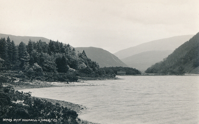
Achnashellach YH. Evening.  The road out from Lochcarron is good – unfenced.  The earth’s shimmering with heat.  The road’s quiet and there’s a shepherd up on the hill with his dog, shouting and blowing his whistle as the dog’s running around sheep, crouching, holding them steady.  A car stops to offer me a lift.  I say no, but thanks.  It’s so lovely and peaceful and apart from the occasional car I have the road to myself as I make my way along to Achnashellach.  Come to a level crossing on the single track railway and wait as a funny little motorised trolley comes along with three railway workers on it.  Ask the level crossing operator  the time. 25 past 4.  Walk past Loch Dughaill, a freshwater loch and the road is lined with brilliant crimson, purple, red flowering rhododendron.  Hillside opposite crashes down into the loch.

Loch Dughaill, Achnashellach.  Acknowledgement Ordnance Survey Seventh Series One Inch Map 26 Lochcarron, 1961 revision.
Partial view of Loch Dughaill, Acnashellach.

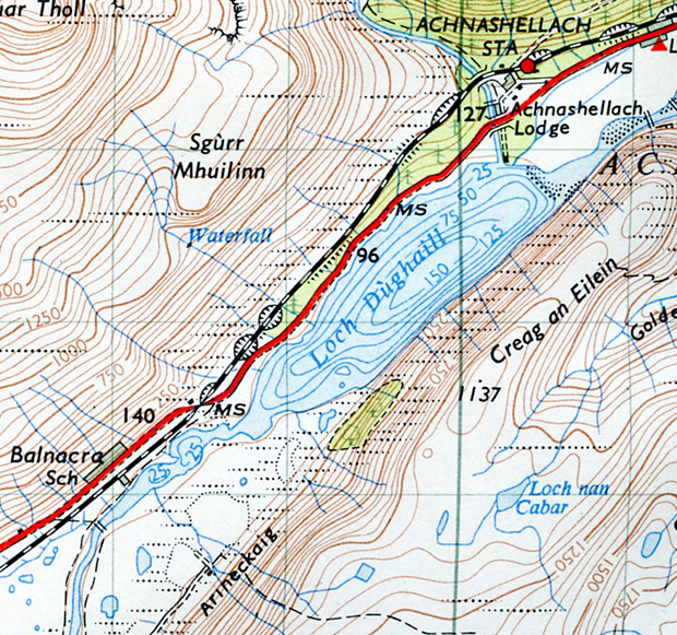
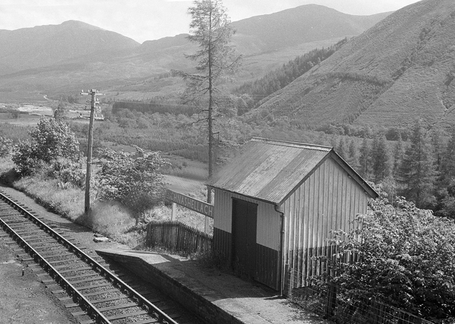
Past Achnashellach Forest and so the hostel. A mess to look at from the outside – old Forestry Commission hut, round the back a lot of old bare cement foundations and weedy grass. But it’s OK inside.  Dave, the warden, is a short bloke, with beard and guitar.  He looks as if he’s been tall at one time and someone’s cut his legs so that he now walks on the stumps of his knees.  A couple of his mates are knocking around.  No one else.  Had a meal of bread, cheese, tomatoes and that fruit loaf.  The fruit loaf was great, only slightly burnt on top.  Big Common Room cum kitchen with a big black iron “No 48 President” range in the middle of the room and the ceiling is covered in posters – including that B.R “Fog, Snow, Ice & Rain – trains get you through” one, which is one of the best visual posters I’ve seen for a long time.

Fog Snow Ice Rain Trains Get You Through!  British Railways poster early to mid 1960s. Slight distortion on reproduction.  Design credited to Dick Negus.
Achnashellach railway station. 1960s.

______________________________

June 1.  Tuesday.  Mid-day.  At the pass between Sgorr Ruadh 3142′ and Beinn Liath Mhor 2849′

` Achnashellach, Beinn Liath Mhor, Sgorr Ruadh and Liathach, Torridon Forest. Acknowledgement Ordnance Survey One Inch Seventh Series Map 26 Lochcarron, 1961 revision.

Up early and washed some clothes and hung them on the line and had a breakfast of porridge, bread, cheese and tomatoes.  Filling.  So left and took the track up to Achnashellach station, on the slope, clustered in by the forest.  Warm.  Small station.  West Highand country station.  Along the track for 20 yards and turn off through gate and along a path, despite a notice saying this is not a right of way, that shooting goes on.  Follow stream.  Pretty straight forward up to the 1250′ contour – where there’s a shelter built last August, built by Dave, the warden, and some “layabouts” as he called them last night.  Crawl in, it’s well built, about the best shelter I’ve experienced.

Achnashellach, Beinn Liath Mhor, Sgorr Ruadh, Coulags, Achnashellach. Acknowledgement Ordnance Survey One Inch Seventh Series Map 26 Lochcarron, 1961 revision.

From there it’s a case of following the River Laire between Sgorr Ruadh and Beinn Liath Mhor and when you look back it’s like a hanging valley.  Tremendous amount of scree.  Both sides of the mountains are bare, the strata jagged, on the left hand side jutting at 50° and at places sticking up like columns.  On the other side, severe folds.  Interesting.

Climb up to the pass.  And suddenly an unexpected, dramatic view of Liathach – a ridge comprising three summits over 3000′.

Liathach in early winter, from Loch Clair.  Photo copyright and source, with grateful acknowledgement discovertorridon.co.uk

This massive cliff like wall facing me, four miles over there, rising up into the clouds. It looks as if it is going right up, touching the ceiling of the sky.  (Mullach an Rathain 3358′,  Spidean a Choire Leith 3456′ and Stuc a Choire Dhuibh Bhig, part of Torridon Forest.  Stuc a Choire Dhuibh Bhig is officially 3002′ .  The height isn’t given on the Ordnance Survey One Inch Seventh Series Map 26 Lochcarron, but Le Patron worked out it was at least 3000′ from the map contour intervals.)

Mullach an Rathain, Spidean a Choire Leith, Stuc a Choire Dhuibh Bhig, Liathach.  Acknowledgement Ordnance Survey One Inch Seventh Series Map 26 Lochcarron, 1961 revision.

Start the return walk to the hostel round by Bealach Ban and follow the stream Fionn-amhainn down to Coulags, a couple of cottages on the main road.  And so back to the hostel.

___________________

June 2.  Wednesday.  Just out of Achnashellach forest.

Craig, east of Achnashellach, over the wooden bridge and following the Forestry Commission track.  Acknowledgement Ordnance Survey One Inch Seventh Series Map 26 Lochcarron, 1961 revision.

Left hostel and walked along the road to Craig, cottages, a small school, cross the railway line walk down to and cross the wide wooden bridge over the River Carron and follow and follow the Forestry Commission track this far.  The sweet smell in the air – like coconut, of  yellow gorse growing by the track.

Achnashellach youth hostel – Craig – Sgurr na Feataig – Loch nan Gobhar – and back to Acnashellach.  Acknowledgement Ordnance Survey One Inch Seventh Series Map 26 Lochcarron, 1961 revision.

I fucking detest flies.  Buzzing around my head as I write this.  (These were not midges, but flies, about the size of house flies, that can detect the faintest moist pore of homo sapiens from a mile off and home in on the face and hair in a unpleasant black cloud.  Often found in coniferous plantations in Scotland.)  They’re flying around in a cloud and irritating me to insanity.  I’ll roll a cig and see if that fixes the fuckers.

The Hostel, evening.   The cig didn’t work, but the further behind I left the trees, and the higher I got, the better it became.  Continued along the track until leaving it, I stumbled down to the burn and crossed the ropey old bridge – wires slung across with boards but most of the boards are missing, and when you get to the other side there is no footpath, despite one shown on the map.

Ropey Bridge to Sgurr na Feataig.  Acknowledgement Ordnance Survey One Inch Seventh Series Map 26 Lochcarron, 1961 revision.

Start climbing up and suddenly there it is, or it seems to be, rather than a sheep track.  Despite planning last night to swing round to the south of Sgurr na Feataig I follow the path zig-zagging up and just before Loch Sgurr na Feartaig there’s a marvellous view of the mountains all around, lochs and the sea in the distance.  And it’s very quiet and peaceful.  Walk on and there’s frogs in the water, like at Crianlarich and yesterday high up there were newts in one of the pools.  Extraordinary.

Resume and Sgurr na Feataig has an impressive cliff/crag face, and walking along the top it’s almost like a ridge in parts.  The slope from here is sweeping down to the road and the railway.  Yes, I like it up here.

Continue walking to  Coire Leiridh, steep in places.

Loch nan Gobhar, Caire Leiridh and the return to Achnashellach youth hostel.  Acknowledgement Ordnance Survey One Inch Seventh Series Map 26 Lochcarron, 1961 revision.

Golden Valley on my left, a curiously English name, given that everything else – hills, mountains, lochs have a Gaelic name.  I wonder why.  Follow the path through the wood (conifers).  Pause on one of the wooden bridges over the river.  It’s wide, white bouldered sun drenched.  Big river bed with a small stream – presumably it gets swollen when the snow on the mountains melts in the Spring.  Which reminds me, I went through some snow fields higher up – and it’s June 2.

When I got back to the hostel Dave was not back from seeing Fred, which he said he was going to do last night.  I cook an indifferent meal of Vesta Beef Curry – I’ve gone off it.  Gone off food.  Youngish couple here tonight, cyclists.  Dave turns up later.

______________________________

June 3.  Thursday.  Loch Morlich YH.  Evening. 

It’s been a day of great luck and glorious weather. The luck: leave the hostel saying good-bye to Dave and am hardly a hundred yards from the hostel when I hear a car coming.  I’m just about to walk under the railway bridge on the Z bend.

Achnashellach youth hostel (Lair), the railway bridge and Z bend. Acknowledgement Ordnance Survey One Inch Seventh Series Map 26 Lochcarron, 1961 revision.

Look back, it’s a Land Rover, raise my thumb and then think Fuck It and give the idea up.  But I hear the Land Rover screech to a halt – long wheel base Land Rover painted blue. Man and wife, tweedy, cap, and what’s great is that they’re going to Inverness.

Achnashellach to Inverness.  Acknowledgement Esso Map 7, Northern Scotland, 1962.

I get in the back and off we set.  But ah what a ride along that narrow twisting pot-holed road, and I’m sitting sideways on one of the bench seat that’s on either side and trying not to get thrown around.  The driver’s belting along, jamming on the brakes, pulling hard into Passing Places,  starting off again, jostling, thumping around and it’s starting to have an effect on me – like making a cocktail of the breakfast I’d just had – slipping around – so I’m beginning to feel sick as we pass from wild barren country into the more green rolling hills and estuary towards Inverness until mercifully we make Inverness.  They drop me off, and I’m very grateful, despite the husband’s hairy driving.

Inverness, 1960s.

Buy a birthday card for Dad and Cairngorms Tourist OS that is fucking awful – shitted up with vile contour colouring and uncoloured roads, so no quick way of knowing which is A, B or unclassified.  Who ever designed it should be shot.

The contour colouring of the 1964 OS Cairngorms Tourist Map that Le Patron thought “vile’.
Ordnance Survey One Inch Tourist Map of the Cairngorms, 1964.
Area covered by Ordnance Survey One Inch Tourist Map of the Cairngorms, 1964 edition.

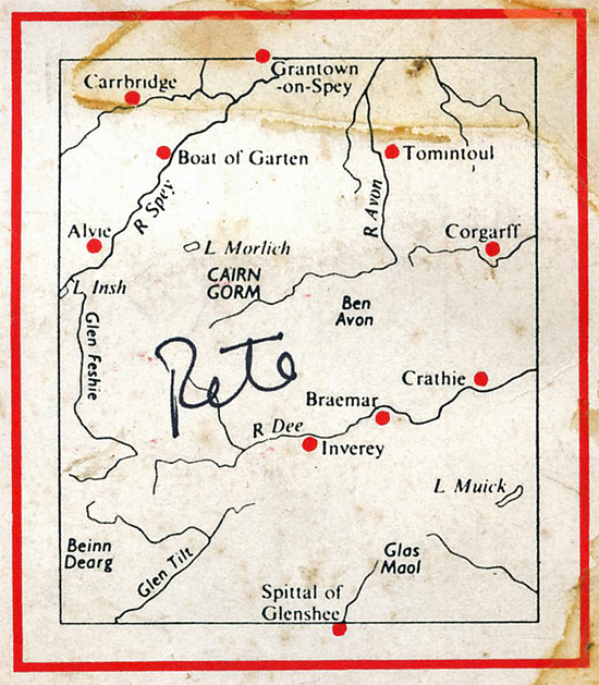
Walk out of town by the high cement wall by the railway and railway sidings and stand by the A9 for Perth and Aviemore.  Have a look at my map, car toots, look up, blue Mini, driver nods in that direction, I nod, car stops, and another lift without hitching.  To Carrbridge, six miles from Aviemore.

Inverness – Carrbridge – Aviemore – Loch Morlich.  Acknowledgement Esso Map No. 7, Northern Scotland, 1962.

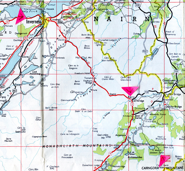
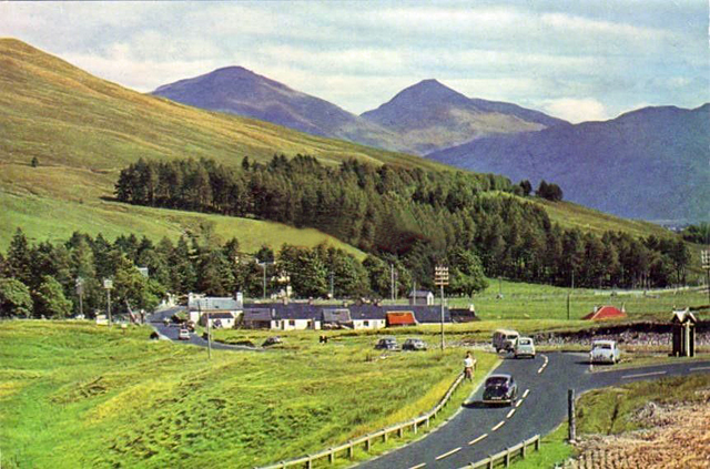
Zooty, plumpish, dark haired wide boy from Glasgow, plastic flowers on dashboard, radio, some sort of salesman, belting his Mini along.  Radio loud – some crummy programme called Mac’s Back – Ken MacIntosh Band with a bunch of lousy singers.  Zooming along through scenery that’s a great contrast from the West Highlands.  Here it’s rolling hills and deciduous trees, very fresh and green leaved.  Pass a peculiar Swiss looking church and there’s the snow capped Cairngorms in the distance.  There’s bits around here that remind me of Bavaria and Switzerland.

His driving was hairy too, in a different way – dangerous.  He overtook a lorry on a dangerous corner.  We’re behind it, he was hesitating, starting to go, pulling back and then blowing a fart in a – Ah fuck it, if I get killed, I get killed mood he overtook and nearly killed us both as a car came around the corner the other way. He managed to nip in between the lorry he’d overtaken and one in front.  Surprised they didn’t blast their horns at him.  Drops me off at Carrbridge.  Which was a relief.  Went into a cafe and had a piss. Had a tea and bought some tobacco and a packet of biscuits.

Carrbridge, circa mid to late 1960s.

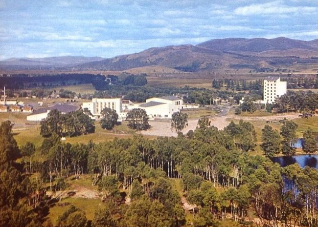
It’s nice and warm and sunny and a pleasant walk along the road to Aviemore, except you have to watch for the cars that quite often zoom past and you nip onto the verge.  Aviemore is in a wide green valley.  String of houses, moderately new council type looking houses, Victorian hotel, the railway station opposite and a Lipton’s store where I buy a lot of groceries.  There’s also a lot of development going on – new ski slope, new string of shops and the most fantastic thing is a big development site going up – sponsored by a couple of breweries and Shell and BP, which includes a cinema, swimming pool, bowling alley, artificial ski slope – the lot.

The new Aviemore swimming pool and centre completed, late 1960s.
The new Aviemore, late 1960s.
The new Aviemore and surounding countryside, late 1960s/early 1970s.
Aviemore to Loch Morlich.  Acknowledgement Ordnance Survey One Inch Tourist Map of the Cairngorms, 1964

Start on the road to Loch Morlich – walking underneath the railway bridge and then over the army type steel bridge that spans the River Spey – wide gravel bedded river here, lined by delicate green tinted leaves.

The road out of Aviemore to Loch Morlich.  Acknowledgement Ordnance Survey One Inch Tourist Map of the Cairngorms, 1964.

Then on a wide road until Rothiemurchus, a hamlet – a school, kids playing rounders, a forge.  On to Coylumbridge, a camp site, stream, trees, looks pleasant.

Campsite at Coylumbridge. Circa  early 1960s.

A stout, tweedy woman with a big old Humber Snipe offers me a lift.  I say Thanks, but I’ll walk. It’s warm, the scenery’s good, so I’ll walk, but thanks.

1956 Humber Super Snipe.  Source Humber/Rootes advertisement.

And so I do.  The scenery’s interesting – flat plain of heather, pine trees, hills rising up.  Yes those wonderful pine trees, not the trees the Forestry Commission plants. They remind me of the pine trees on the coast at Paksostan where the tent was pitched.  (The summer of 1964 in the former Yugoslavia).  Heavy smell of warm pine resin and pine needles in the air.  Reach the loch.

Loch Morlich, 1960s.

Quite a longish walk along by the lochside making for the YH.  Tourist cars pass, and I pass a big Rank ‘Road Inn’ being built.  Yes, there’s money in them hills, skiers money.  Further on there’s a shop, mostly catering for a camp site.  Go in and buy some porridge oats.  Finally reach the YH.  Run by a Manchester bloke, glasses, pipe smoking, seems to be in a daze half the time, and there’s an Arts Conference (whatever that is) happening at the YH, so I decide to move on to Inverey tomorrow.  As it is, it’s pretty full with Scottish school kids tonight.  Eat an overpowering meal of omelette and chips and had an urge to drink water all night.

_____________________

Walking to Scotland 1965

Next

Journey’s End

Part 8:    The Cairngorms.  Perth to Glasgow. A day and night hitch back to London (with a Freddie Garrity look-a-like driving his lorry madly over Shap).

Summit of the Lairig Ghru Pass, Cairngorms.
Invercauld Bridge, near Braemar.
Tolmount to Glendoll youth hostel. Acknowledgement Ordnance Survey One Inch Tourist Map The Cairngorms, 1964

_____________________________________

Advertisement
Author petegraftonPosted on August 23, 2017July 3, 2021Categories Photography, Political & Social History, PostcardsTags Aonach Dubh, Aonach Eagach, Ardarroch, Ardintoul 1960s, Ardnashellach youth hostel, Aviemore 1960s, Aviemore developement 1960s, Beinn Bhan, Beinn Fhada, BeinnLiath Mhor, Betterware salesman, Carrbridge 1960s, Drumbuie crofts, Duirinish 1960s, Fort William 1960's, Giovanni's Room, Glen Coe, Glen Coe youth hostel 1960s, Glen Nevis hostel 1960s, Glenelg, I've Got a Tiger in My Tank, Inverness 1960s, James Baldwin, Ken Macintosh band, Kinlochleven 1960s, Kintail Mountains, Kishorn youth hostel, Kyle of Lochalsh 1960s, Kyleakin ferry 1960s, Kylerheah ferry 1960s, Letterfearn 1960s, Liathatch, Lipton's store Aviemore, Loch Cluanie, Loch Dughaill, Loch Duich, Loch Linnhe, Loch Morlich youth hostel 1960s, Lochcarron, MacBraynes Royal Mail Highland buses, Ordnance Survey One Inch Map 26 Lochcarron, Plockton 1960s, Rank Road Inn Loch Morlich, Ratagan youth hostel 1960s, River Carron, Sgorr Ruadh, Steall waterfall, Stromeferry 1960s, Vesta beef curry4 Comments on Walking to Scotland 1965. Part 7. Glen Coe, Fort William….

Walking to Scotland 1965. 6: Into Scotland

Walking to Scotland 1965

Part 6: Into Scotland.  Glasgow, Loch Lomond, Crianlarich, Oban, Loch Awe and Cruchan and on to Glen Coe.

The Story So Far…  The Lake District: Wonderful mountains, but frightning in bad weather.  A hound on Hellvellyn and a hairy, heart stopping time in low cloud on Lord’s Rake 3162′.  Magnificent deep U shaped valleys and pictureseque hamlets.  And rain, and rain, and rain, enough rain to  turn the Sahara  green.  And three Mod girls.

To Come  Liking sooty Glasgow, mysterious MOD development near Garelochhead. Loch Lomond.  Frogs  at 3100′ in a peat pool near Beinn a’ Chroin and the Crianlarich hostel warden with a sense of humour.  Loch Awe and Ben Cruachan before the dam, (but nearly completed). Oban station before it was demolished, and on to Glencoe.

Loch Lomond.

May 10.  Monday evening.  Glasgow YH.

To catch up on the day – Left Cockermouth YH at 9.45 am, after shave and dubbining  my boots.  Chatted to the warden last night – just me and him in the hostel, as he cooked his meal in the self-cookers along with me and classical music blaring out of his sleeping quarters.  Later we got talking in his sleeping quarters.  He’d been in electronics in the GPO, but four years ago chucked it in and has been bumming around ever since. We ended up talking about life and art and literature – nice bloke.  When I left this morning Memphis Slim was belting out of his living quarters.

Walked along the river into the town – old mills, narrow alleys, nice town.

Cockermouth, 1960s.

Walk out to the roundabout for the road to Carlisle, and one of the first vehicles that stops is going there.  Great.

Cockermouth – Carlisle – and into Scotland.   Acknowledgement Esso Map No. 5, Northern England.  1964.

Bloke in a Thames Trader van.  He’d been around and therefore thought he knew everything.  So I got told a. about his intended holiday camping with the family in France, b. 35mm cameras – he was a photographer not a snap shooter, c. how the bloke in front was driving badly, d. what happened to him when he was in the Himalayas and the marvellous photograph he took of a tiger’s victim – a young girl, and as we entered Carlisle  – e. where he was born.  Still, he wasn’t too bad and grateful for the lift.  Dropped me off at the road for Scotland on the other side of Carlisle.

Hitch but no go, so move further up the road to Kingtown, where there is a branch in the road off for Edinburgh, and walk a hundred yards along the road for Glasgow.  Hitch but still nothing stopping, even though it’s a week-day.  Munch a packet of biscuits.  Hot, sunny day, hitch again and a small Austin stops and it’s two English students returning to Dundee University who give me a lift nearly all the way to Glasgow, bar ten miles.

A74: Ecclefechan – Lockerbie – Beattock – Lesmahagow.   Acknowledgement Esso Map No 6 Southern Scotland, 1962.
Esso Road Map No.6 Southern Scotland, 1962.

The driver wasn’t bad, but his friend/mate Joe was a cold, sneering bloke.  The driver studying chemistry and Joe studying social science.  Both were pretty mindless as blokes go, but grateful for the lift.  They drop me at Newhouse, to the east of Glasgow.

Lesmahagow – Newmains – Newhouse – Glasgow.  Acknowledgement Esso Map No 6 Southern Scotland, 1962.

So Newhouse, 10 miles to go into Glasgow.  Have a cig, hitch and an Austin 1100 into Glasgow, the east of Glasgow, from a youngish English salesman – “I detest Surrey and Essex” he says.

WD & HO Wills cigarette factory at night, Alexandra Parade, Glasgow.  Circa late 1950s/early 1960s.  The factory closed a good while ago.   Photo source The Scotsman.

Where he drops me off is a big WD & HO Wills cig factory across the way.    The weather’s still sunny and I go into a Co-op to get toothpaste and some provisions and have to stop myself smiling at the Scottish accent – reminds me of my Grandmother.  Yes, I like Scots – warm, friendly people.  (Le Patron’s family was from Scotland on his Dad’s side.)  Outside the Coop it’s warm and women and prams and young children – “Och, he’s a wee little rascal” and tasty looking school girls.  It’s 4 o’ clock.  Get a No.10 bus that goes into the city centre and on to Charing Cross.  Glasgow buses are really rough – really bumpy – and  a bus conducteress who reminds me of Aunt Edith.

Glasgow Corpotation bus, East End, circa ealy 1960s.  Acknowledgement and photo source parkheadhistory.com        No photographer I.D.

Off at Charing Cross.

Charing Cross Glasgow, early 1950s. It would have looked more or less the same in 1965, minus the tram lines.  The look dramatically changed when buildings were demolished prior to the M8 smashing through in 1972.

Consult the SYHA handbook, ask directions, and make my way to Woodlands Terrace which is beautiful, overlooking a big park. (Kelvin Grove Park).

Glasgow youth hostel, Woodlands Terrace, early 1950s.

The youth hostel is Victorian.  Enter and sign in.  Pleasant enough inside and a seemingly clueless warden, but he’s pleasant too.  Cook myself a meal in a near empty self-cookers in the basement of spam, beans, chips.  Sit in the common room trying to decide where to go tomorrow.  Decided on Loch Lomond.  Warden and wife came in, lit the gas fire, we got talking.  Turns out they have an assistant warden vacancy during the summer.  Later three Australian girls turned up.  Then some Australian blokes, a couple of Finns, Germans and a Canadian, who rolled up at 10.30 p.m. (In 1965 the international flights airport for Scotland was Prestwick on the Ayrshire coast.  All flights to and from North America took off or landed at Prestwick.  For North Americans and those from Australia and New Zealand, Prestwick was the starting point for hitching around Europe, and once landed the train would bring them up to Glasgow.  In 1960 Elvis Presley had touched down for two hours and stretched his legs at Prestwick, on his home trip from Germany after serving in the army.)

___________________________________

May 11.   Tuesday.  Glasgow YH, around 10 am.

Up 7.30 and after breakfast saw the warden and he’s got my name and address as assistant warden for July/August/September.  He’ll confirm in mid-June.  I hope he does.

Yes, you definitely feel that Scotland is a different country – for a start – ah, that clapped out phrase – for a start, for a start the police are different – black and white chequered bands on their peak caps and the cars look American in style – flash Fords with Glasgow Police on the door and the crest of the city, and several Police Landrovers.

Glasgow City Ford Police car, 1963.   Photo Unknown source.

Then there’s the “Licenced Grocer”, plenty of those, and potato and soda scones.  The one place to go if you want to find out how areas differ is the baker’s shop.  In the west of England/Somerset lardy cakes, in the Peak District large pancakes, in Bradford long buns, but no doughnuts like you get in the south. Here, soda scones, potato scones and pan loaves.

8.30 p.m. Loch Lomond YH.  Left the Glasgow YH about 10.30 and did some supermarket shopping, coffee, Vesta meals, jam, bread and then spent some time trying to find a place that sold the Loch Lomond/Trossachs Tourist O.S.  Eventually got it.

Ordnance Survey One Inch Tourist Map Loch Lomond & The Trossachs, 1961 edition.
Area covered by Ordnance Survey Tourist Map of Loch Lomond and The Trossachs. (Reverse of the 1961 edition).

I’d asked the warden the best way to get to Loch Lomond and he said to head for Great Western Road.  Between Charing Cross and the Great Western road there were no bogs and I was dying for a piss.  Ridiculous so ended up nipping into the Botanic Gardens and having a pee behind a bush.  (In fact, there were public toilets, including in the Glasgow Botanical Gardens.  Le Patron just did not see them.)

Great Western Road and the main entrance to the Botanic Gardens, circa late 1940s.

Re-emege and back onto the Great Western Road, heading out west.  It’s starting to drizzle.  I look back and Glasgow is grey and the streets are wet and shiny and the green/orange/cream coloured buses roll past, and crimson Central buses, and heavy transport – and I don’t know why, but I like Glasgow – really looking forward to getting that assistant warden job.  Hope I get it.

East Kilbride bound Central double decker in the Glasgow area, circa early 1960s.   Grateful acknowledgement to centralsmt.co.uk and the D.G.Macdonald Collection.

Walk along hitching, but no go.  Keep walking and come to the outer suburbs.  Buy some potato scones and some biscuits.  It’s still drizzling.  Munching on the biscuits and hitching and at last a beat up old lorry stops, going into Dumbarton.  It’s a real crate on wheels – 30 year old Dennis lorry – “Aye, the Rolls Royce of lorries”, says the driver, who’s got a fiery ginger Scottish moustache.  It really is an old slogger.  Square window windscreen, side windows grimy and one broken, and the engine between me and the driver.  And Christ, did you get jogged around in that cab – bump, rattle, bump – as it slogged on down the road, the engine roaring.  This is supposed to be the Rolls Royce of lorries?

1930s Dennis lorry.  Grateful acknowledgement hmvf.co.uk
Glasgow – Clydebank – Alexandria – Loch Lomond youth hostel. Acknowledgement Esso Map No.6 Southern Scotland, 1962.

Drive past Clydeside on my left, ships being built, see the white glare of  oxy-acetylene torches.  The driver drops me off where the road branches off to Loch Lomond and he continues to Dumbarton.  Try and buy Cadbury’s Marvel (dried milk), but no go anywhere, so wait for the Alexandria/Balloch bus and get it into Alexandria.

Alexandria – big naval office building there and as you walk out of Alexandria there’s a block of prewar flats – dull dark red brick tenements on wasteground.  Just them.  Nothing else, except rubbish and at the bottom of them, on the ground floor small dark shops and most of them have bars and shutters or reinforced wire behind the glass.  Reminds me of places I’ve seen in Italy – Foggia, for example.  Then a boring walk from Alexandria until the drive off to the YH.

Alexandria to Loch Lomond youth hostel (Auchendennan).   Acknowledgement Ordnance Survey One Inch Tourist Map Loch Lomond & The Trossachs, 1961.

Sit by the drive on the grass, two pairs of females pass me going up to the hostel so I reckon it must be getting on for 4 p.m. (Scottish youth hostels opened at 4pm, not 5pm like the English youth hostels.)  Having rolled a cig I trot after them, puffing away.  And ye Gods – it’s a whacking great Victorian castle/mansion monstrosity, turret towers, the lot.

Loch Lomond youth hostel

It’s not quite four and there’s a small group of us waiting at the entrance.  After a while hear the door getting unlocked and a young Englishman lets us in.  I’m given Dormitory C.  Four flights up. The place is just right for a 1930 Hollywood melodrama or a 1965 Hammer horror film – heavy wood panelling, neo-Greek dames, sculptures on the walls, scrawlings and Victorian cloth dark green wallpaper.  Eventually make C.  Nice view up there.  Make up my bed and descend to the self-cookers.

Cook a Chow Mein dinner and have a really beautiful cup of coffee – really tasted good, and only cheap supermarket stuff.  It turns out the big cold dining room is also the Common Room which is quite shattering – no books, no heat, no nothing.  Later a young blond Cockney bloke turns up in shorts and then two of his Scottish mates, and two Danish girls, two New Zealand girls and three girls from Australia who were at Glasgow last night.

______________________________

May 12.   Wednesday.  Just past the farm “Highlands”.

Loch Lomond youth hostel – Arden – Highlands – Glen Fruin – Auchengaich Reservoir.  Acknowledgement Ordnance Survey One Inch Tourist Map Loch Lomond & The Trossachs, 1961

Just past the farm “Highlands” on unclassified road.  Up at 8.30 am, out at 10.45 after talking for some time to the young assistant warden – the English bloke who opened up yesterday afternoon.  As he said, he’s bumming around and doesn’t know what to do.  If I get the job at Glasgow YH I might see him again.  Set off on the A road which is quiet, that runs along by the side of Loch Lomond.  Loch Lomond pleasant and calm and it’s close and sweaty. Try to get some tobacco at the Arden P.O and petrol station, but no go.  Turn off onto the B831 and now onto this unclassified road that takes me along Glen Fruin.  Moderately pleasant, marred by a dull ache in my left foot from a knock I got in the Lakes. Skylarks, pee-wees and curlews singing above me and near me.

Dinner-time.  Walked along Glen Fruin.  A few farms, a stream and about to start up the track to a small reservoir, marked as Auchengaich Reservoir.  Just eaten the rest of the potato scones which were alright, and some biscuits.

Auchengaich Reservoir – Beinn Lochain – Cruach ant-Sithein – Glen Douglas. Acknowledgement Ordnance Survey One Inch Tourist Map Loch lomond & The Trossachs, 1961.
Auchengaich Reservoir (reservoir shown but not named) – Beinn Lochain – Cruach an t-Sithein – Glen Douglas.   Acknowledgement Ordnance Survey metric Landranger Map 56 Loch Lomond & Inveraray area, 1989.

Inverbeg Youth Hostel, late evening. To catch up where I left off.  Walk up the hill to the reservoir, a small little affair, and then along rough sheep tracks up to the watershed and start to go down the other side.  View’s pretty good – Beinn Lochain and Beinn Eich and the ridge between them towering directly in front of me.  It’s warm up here with a slight breeze.

Following the descent it’s a steep climb up the small stream that runs off the saddle between Cruach an t-Sithein and Beinn Lochain, and then drop down the other side – view of snow clad, craggy pinnicle mountains over to the left.  As I descend I come to a big Howard site – lorries, diggers, cranes extending over three miles of the valley and big, and I mean big fencing all around.  God knows what the site’s for.  I followed the fencing all the way along, thinking I’d get access to the Douglas Glen. But I saw that it extended all the way down the valley.  (This was part of the Garelochhead Training Camp.  Wikipedia notes that it became a military training area in 1940.  The 1965 construction work that Le Patrol stumbled across is assumed to have been a significant extension of the area, with an increased infrastructure of service roads and facilities, and a high security fence.  Wikipedia correctly notes that the area extends from Glen Fruin to Glen Douglas in the north, covering over 8000 acres.  This detail is omitted from the Ordnance Survey metric Landranger Map 65, apart from the Danger Areas marked to the south west of it.  Also note the roundabout marked to the south east of Gairlochhead railway station, with no roads radiating off it.   The Garelochhead training area is also identified in Fortress Scotland by Malcolm Spaven, Pluto Press, 1983.)

Military access road, Garelochhead Training Camp. Source Geograph.org.uk

Cursing I retraced my steps, the hillside wet and slippy and crossed a stream, asking the time from a bloke doing some curbs on the new road, with a young mate.  Nearing 5 pm.  My foot is now hurting like fuck.  Descend to Douglas Water by a forced alternative route, walk along it as it falls towards Loch Lomond.   Find a place to ford it and get on a track running by it, which turns into a made-up road that doesn’t help my foot any.  It’s a pleasant valley.  Stop for a cig, foot throbbing.

Inverbeg youth hostel.

Get to the hostel.  It’s nice and cosy, timber built in a great situation, the Douglas Water running into Loch Lomond and wooded banks overlooking by some 100′ the Loch and Ben Lomond over on the other side.

Ben Lomond and Loch Lomond from Inverbeg.
Loch Lomond.

The warden’s a young bearded, cricket sweater, tartan trousered and bed slippers bloke.  No-one else here tonight, and a load of left over food in the self-cookers.  But I’ve run out of tobacco – no shops, no pubs, nowhere to buy it, except  a P.O. so I may get some first thing tomorrow morning when it opens otherwise I’ll be a nervous wreck until I get to Loch Ard.  (Le Patron’s plan was to get the foot ferry across the Loch to Rowardennan and walk to Loch Ard in the Trossachs.)

Inverbeg youth hostel – Rowardennan.    Acknowledgement Ordnance Survey One Inch Tourist Map Loch Lomond & The Trossachs, 1961.

_____________________________

May 13.  Thursday.  Crianlarich YH.  Evening.

Told late last night by the warden that the ferry across to Rowardennan wasn’t running so  decided to hitch up to Crianlarich.

Inverbeg youth hostel to Crianlarich.  Acknowledgement Esso Map No.6 Southern Scotland, 1962.

I woke up early to a beautiful, beautiful day – the best easily since I started out in March – really hot right from the start and the Loch and Ben Lomond looking serene.  Left after breakfast and there’s a caravan park by the lochside on a great site.  Reminded me of some of the Continental camp sites – there’s a shop and proper toilets, and trees.  I go up the drive and  into their shop and to my relief and delight they sell tobacco.  Buy two ounce tin of Sun Valley.

Sun Valley cigarette tobacco.

Roll and smoke a cig at the water’s edge, looking across to Ben Lomond.  Water clear and still and the opposite hills are reflected in it.  Walk back to the main road – well it is the main road, but it is quite narrow, and not much traffic.  Start walking, heading for Crianlarich.  The road tightly follows the shore of Loch Lomond, wooded slopes on the land side as the hills sweep up and wooded on the narrow strip by the Loch side.  Road is narrow, winding and with  Z bends.

The A82 (T) road north of Inverbeg – “Narrow, winding with Z bends”.  Acknowledgement Ordnance Survey One Inch Tourist Map Loch Lomond & The Trosssachs, 1961.

Hitch the occasional passing traffic and a pleasant bloke going to Oban in a Ford Anglia stops.  He belts along and drops me off at Crianlarich and I discover it is only 11.30 a.m.

Crianlarich circa late 1950s/early 1960s.

Buy some food in the village store.  It’s still very hot.  Decide to climb Ben More 3843′.

Ben More from Crianlarich, 1960s.  The bridge is the railway bridge and the existing Crianlarich station is just out of the photo, to the right. The single track railway line at Crianlarich splits into a line to Fort William, and a line through to Oban.

Crianlarich is on the edge of the hills, on the bend in the valley of the River Fallan, a flat bottomed valley, very tranquil and foreign looking (again, reminds me of the Continent) with the river meandering about and a brand new black tarmac wide road running along the valley and by the side the single track railway as I start out for Ben More.  As you walk out of Crianlarich the river broadens out and gets called Loch Dochart – a small lake, a few islands of sand and weed and a more substantial island of rock with the remains of a castle on it.  And to my right is Ben More rising up from the valley, doesn’t look anything like 3843′.

Crianlarich to Ben More. Chrianlarich still had two stations and a railway line to Callander in May, 1965.  The Crianlarich – Callander section closed later that year, in September 1965.   Acknowledgement Ordance Survey One Inch Tourist Map Loch Lomond & The Trossachs, 1961.

Start the climb from Benmore farm and it’s a straight forward trudge up a steep grassy slope.  Zig-zag walking to take out the gradient, stopping often, so that it’s not hard, but tedious.  See a rock above me and keep making for that thinking it’s the top, but it’s not.  Eat some biscuits and continue, heading for a crag that I think is the top.  Make for that, more trudge, trudge, trudge, but when I get there it’s still far from the top, so more slogging over the grassy slope, until, yes, the summit.  Dead boring mountain. Quite a fine view though – jagged mountains all around, as far as the eye can see, and nearly all snow covered, the valley below and to my right in the distance a large loch.  Close-by the only exciting thing to look at is the ridge between Ben More and Stob Binnein, it’s face covered in snow.  Sat and wrote a postcard to parents and then started murderous descent down, just the steepness that got me, nothing difficult, exciting or challenging.  Cross the Benmore Burn and make my way down to the road.

Back in Crianlarich I buy some more food from the store and find out it is 5.30 p.m..  Weatherwise it’s been a glorious day.  Trot up to the hostel by the railway station.  Timber building.

Crianlarich youth hostel as it was in the 1960s, now replaced by a newer hostel.

Enter.  Take off my boots.  No warden around so go into the dormitory, unpack my rucksack, make up my bed, as I come out with my food the warden comes in.  Old bloke. “Now my lad, who said you could wander in?  This is how trouble is caused, people wandering in and out.”  So I think, this bloke’s going to be a bugger, but he turns out to be OK.  Just his way of having a joke and keeping a stern face.  Buy a tin of Goblin Beef Stew and as I’m cooking it I suddenly feel very sick – too much sun today? – and go and lie down and then have a crap and feel better.  Back to the kitchen and serve the stew with spuds.

Later.  Later in the evening a middle-aged cyclist comes in.  He has a peculiar shrill little  laugh and the two of us make an effort at conversation.  Later still a young bloke turns up, and when he’s unpacking his stuff in the dormitory the warden tells us that he met him coming up the road and told him the hostel was closed as the warden had been taken away with an acute attack of diarrhoea – and I laughed.  Yes, a warden with a sense of humour.

10.30 p.m  Young bloke’s mate turns up.  Both school lads taking exams. Now for bed.

__________________________________

May 14.   Friday.  Mid day/early afternoon?  Near An Caistel 3265′

Oh, it’s been a great glorious day so far, weather superb.  At one point I was about to curse as it was getting too hot, but I just sat down and took my sweater off, sitting in my shorts and boots.  And a great walk too.  When I woke up this morning the sun was coming through the dormitory windows and was already warm.

Before I left I went down to the village store to buy food, and to the P.O. to get a postal order the warden wanted.  He gave me the money.  Left the hostel and trotted down the quiet A82 for about two miles until coming to Keilator farm, up a track on my right.  On the left a gate into a field.  Climb over it and make for viaduct going under the railway line. A shepherd shouts and directs me to go through a gate further along and get on the right side of the river.

Taking his advice, I do, passing under the railway further along and cross the wooden bridge over the River Falloch and then onto a track that runs by the river – rough track, rough moorland pasture.  Leave the track and make for Sron Gharbh 2322′ which takes some time getting up.  It was on Sron Gharbh that I stripped off and sitting not quite ballock naked ate a packet of Royal Scot biscuits, had a cig and day dreamed, stretched out,  the big blue sky above me. The beautiful glorious heat.  A panorama of pyramid, triangular snow capped peaks all around and a slight heat haze.  Ben More looked a bit more impressive from here, like a big cone with crags.  Stob Binnein looks good too, looks like a volcano.

So from Sron Gharbh along Twisting Hill to An Caisteal.  Twisting Hill is a magnificent twisting rocky ridge.  It really is great to walk along, not as narrow as Striding Edge, but it’s the twisting that makes it a so good.  Valleys below, streams in their early stages and nothing else.  On the edges of the slopes on Twisting Hill some extensive snow-fields.  Crazy, where I’m sitting, where I’m writing this in full sun, by my side is snow.  Scrape off the top layer and taking the cleaner ice crystals underneath, suck them.  There’s several pools of water with flies, mosquitos or something buzzing over them.  There’s a continual buzzing, humming sound.  The rock’s pretty crystalline, sparkles and large pieces of white crystalline rock in places too. Otherwise a grey sparkly rock and if you have a close look at it you can see that it’s been under some stress.  And up in that oh so lovely blue sky – wispy,  puffy white clouds, like blobs of cotton wool.

So continue along to the cairn, the rough pile of stone that marks An Caistael.  A steepish descent down to the col between An Caistel 3265′ and Beinn a’ Chroin 3104′ – a bit of crag as you climb down to the col.  There’s a great view here, nice craggy mountains all around, and – extraordinary –  in the col there’s a  peat pool with frogs in it.  I sat by the pool and waited for one to surface and caught and inspected it – the Common Frog – and put it back, then another one surfaces.  Walked around the pool.  There are some dead bloated ones lying on the bottom.  It’s only a foot deep and dead clear, brown peat bottom.  Nearby is another smaller pool with a load of misty white spawn – dead by the looks of it.  But crazy, frogs up here, at this height.  How do they make it?  And what happens when the snow comes?  Really was crazy, and great.

The Common Frog living the high life at the col between An Caisteal 3265′ and Beinn a’ Chroin 3104.  Acknowledgement Ordnance Survey One Inch Tourist Map Loch Lomond & The Trossachs, 1961.

Scramble up Beinn a’ Chroin, a lot of crag to negotiate, then on, dropping down below Stob Glas and on to Meall Dhamh, a crag outcrop and Grey Height.  Go down the valley of the R.Falloch, back towards the A82, and then descend between Hawk Craig and Grey Height. Pause to have a cig, looking down at Crianlarich station, a diesel at the platform and the station surrounded by trees.  It looks like some Bavarian station, with the trees and the hills all around.  As I descend I thought of an idea for a play – “The Day Trip” – about a day trip to Calais – it passed the time as I walked along the road, and laughed out loud at a couple of scenes that I thought of as I got near the YH.  Came in the back way, over a fence and there’s the warden, this old strong boy with snow white hair at his garden, and his alsatian greets – barks – at me, which he tells to shut up, as he grins at me.

And surprise of surprise, as I’m taking my boots off guess who turns up – “Oh I say Timmy, isn’t it fun”.  Yes, unbelievably the couple who were at Glascwm way back in Central Wales.  They took some time to really work out who I was, even though I told them about Glascwm, and when the penny finally dropped she said “Oh, how jolly marvellous”.

Besides them, two dumb cyclists turned up – I’m NOT being funny, literally dumb, using sign language.

______________________

May 15.   Saturday.  Oban Railway Station.  11.30 a.m.

Left hostel about 9 a.m and start down the road for Oban. Not much traffic but just outside the village I hitch a car and it stops just ahead of me. Run up to it.   Vauxhall Velux with three American girls.

1960s Vauxhall Velox.   Source and Acknowledgement favcars.com

They’re going to Glencoe and drop me off at Tyndrum.  Still not many cars, walk along, hitch the few that pass but no go.  Low cloud with patches of blue sky that looks as if it may clear up.  Barren looking hills on either side.

Crianlarich – Kilchurn Castle and Loch Awe – Oban.  Acknowledgement Esso Map No.6 Southern Scotland, 1962.

Hitch and a Mini van stops, youngish bloke going to Oban.  Great.  Pass Cruachan – lot of disruption and activity from building the power works, H.E.P they’re building.  (H.E.P: Hydro Electric Power.).  The road runs partly along Loch Awe.  More plant, Nuttalls lorries, etc.

Road into Oban is peculiar.  Some jerry buildings and pylons.  Scenery peculiar as you come in, running by the Loch Etive estuary – little hummocks, hills, then larger ones.  Yes Scotland is an interesting, foreign country.

The A85 into Oban from Connel showing the railway junction to Ballachulish. This branch was closed in 1966.     Acknowledgement Ordnance Survey One Inch Tourist Map Map Ben Nevis & Glen Coe, 1959.
Oban, circa 1950s. The railway terminus is on the left.  Despite protests the listed station was demolished by British Rail in the 1980s.  A brick cube now replaces it.

Writing this in the Oban railway station, very light, glass roof, it’s a terminus.  Bright place only as I sit on this bench there’s a faint tang of urine, and there’s match sticks and spit on the floor.  Over there is a John Menzies book stall and Gentlemen.  On the other side, Ladies Waiting Room, parcels office and in the middle two benches and a couple of trolleys.  And the strange thing is that as I sit here I’m aware that everyone looks shabby and scruffy – their clothes just don’t fit and hard unpleasant faces, old men, old porters and quite a few down and outs.  And a couple of old-timers sitting next to me on this bench are speaking gaelic.  In a way it reminds me of those people at Maribor station, sub-standard, ill fitting scruffy clothes too, with unpleasant faces.  Not the expression – the face. (Le Patron was in Maribor in the then Yugoslavia in 1964.)

Bought the Tourist Map for Glencoe and Fort William, which was the reason for coming into Oban.  Now to start thinking about hitching back to Cruachan YH.

Ordnance Survey One Inch Tourist Map Ben Nevis & Glen Coe, 1959 revision.
Area covered by Ordnance Survey One Inch Tourist Map Ben Nevis & Glen Coe.

Afternoon, Kilchurn Castle.  Before I left Oban I bought some groceries, including a 2lb (1 Kg) Christmas pudding reduced from 5/- to 2/6 to get rid of them in the Oban Co-op.  Aye, an exotic pudding to go with my Vesta Beef Curry.  Stood on the corner of town and started hitching. View of the sea down there where I’m standing, rocky wooded cliffs, looked alright.   Two girls come out of the town in my direction and stop 15 yards before reaching me and start hitching.  Highly unethical amongst hitch-hikers to do that.  I packed in hitching, waiting for them to get a lift.  Two Wimpey lorries pass them and the driver in the first lorry is grinning and sticks his finger up and down in an imaginary fanny.  I laughed, man.  And laugh now as I write it.  Car stops for them, but pulls away and they’re still there.  Thinks –  serves them right.  2nd car stops and they’re away.  I start hitching again and luck of luck a van stops, going six miles past Loch Awe.  I get in, sitting between the driver and his mate.  They drop me at Lochawe village.  It’s around 1.45, so I decide to make for Kilchurn Castle.

Lochawe village, site of Cruachan youth hostel and Kilchurn Castle. Cruachan youth hostel not shown on this 1959 revision map had a curiously short life, opening in 1963 and closing in 1971. The Lochawe railway station on the Glasgow- Crianlarich – Oban line closed in November 1965, but was reopened in 1985.  Map Acknowledgement Ordnance Survey One Inch Tourist Map Ben Nevis & Glencoe, 1959.
Kilchurn Castle, Loch Awe.

Cruachan youth hostel, evening.  After getting dropped off I trot along the road, past the hostel, round the bend, passing two monstrous Victorian turret tower mansions – hotels, on either side of the road, then over the bridge that goes over the River Strae and River Orchy where they join and empty into Loch Awe.  Look at my map, trying to locate the footpath to Kilchurn Castle when another hiker/hitch hiker from Edinburgh trots towards me along the road.  Have a chat, a cig, a laugh.  He shoots off,  going to the hostel.

Find the footpath.  The castle’s  on a small peninsula protruding out – a flat green peninsula with some cows grazing, with a pleasant little wood to the side.  The castle was a tower built in mid fifteenth century with a big extension in 1693 the notice says.  There’s also a notice saying it is closed to the public awaiting repairs but there’s nothing stopping you getting in.  So enter a dark room.  Get my torch out and follow the steps going up.  On the first storey I look down on the grass courtyard below me.  Another flight of steps up to the turret tower.  Whole place to myself.  It’s great – the loch all around, and I’m having trouble trying to imagine anyone ever living here  – someone coming up the same steps I’ve just climbed up. What was he doing on May 15th, around 4 p.m. in 1693?  What was he thinking?

Descend down into the grassy courtyard.  Two other turret towers still in reasonable condition and outer walls O.K.  Rest of the castle is in an advanced state of falling down.  Little holes in the towers for muskets.  Walk around the castle on the outside.  It’s good.  Notice their sanitary arrangements – genuine seventeenth bogs in the turret towers: little stone seat with a hole, it just drops straight down onto the grass.

Trot back to Lochawe, go in the shop, find it’s 4.30 p.m. buy some cigarette papers and matches – “Scottish Bluebell” – go to the hostel and check in.  Two girls, three blokes, climbers of sorts from Edinburgh University.  And the bloke I met on the bridge, only his mate and two Australian nurses didn’t turn up, so he’s on his tod.  Makes some soup, gives me some, trots off to the pub, returns, makes some coffee, again gives me some.  In the end he plays cards with three cyclists who turned up.  Warden here is a youngish woman.

_____________________________

May 16.  Sunday.  On the way to Ben Cruachan 3689′

At the cairn, very small pile of stones at 3163′.  On the ridge to Ben Cruachan 3689′.  Coming up to the cairn I came through a snow field, digging in, scrambling up a cliff face, vertical strata jagging upwards.  There’s cloud all around, but it’s very clear.  The cloud is just above all the peaks, like a curtain not quite touching them.  No heat haze and the mountains, the small lochs, estuary out to sea and the islands are all clear and it looks good.

Ben Cruchan (top left) seen from Oban Bay.
Ben Cruachan and the Cruachan Dam.   Acknowledgement Ordnance Survey One Inch Tourist Map Ben Nevis & Glencoe, 1959.

No wind, either.  Very quiet and peaceful up here.  Some great snow-capped peaks in the distance and Ben Cruachan over there to my left.  Nice triangular shaped mountain with two ridges leading off it.

Ben Cruachan seen from the south, near Kilcrenan.
Ben Cruachan, and site of dam and road.   Acknowledgement Ordnance Survey One Inch Tourist Map Ben Nevis & Glencoe, 1959.


Ben Cruachan – Taynuilt summit.

Cruachan Hostel.  Towards 10 p.m.  From the 3163′ pile of stones cairn walk along the ridge to the 3273′ point marked on the map.  It’s curious – a wooden box with bright neon orange paint peeling off.  Continue the ridge walk along to Ben Cruachan, on one side looking down at the new dam and works, right down there.  Can see a new road leading up to the works and on the other side – the north side – of the ridge a cliff face dropping down and extensive steep dropping very thick snowfields.

Several youngish blokes pass me, returning from the summit, and a middle aged couple. Have a talk with the middle aged couple – they’re going to Yugoslavia in the summer to do some hill walking near Dubrovnik.  I continue up to the summit, to the trig point, thinking I’ll have it to myself,  but two blokes and two birds up there with cameras out.  Chat a bit.

I descend.  Taking it slow.  Been taking it slow, been taking it whimsically slow all day. Thinking about things in general. Eventually I’m descending near the dam works.  Quite something.  Lot of equipment around.  A big Euclid lorry, massive thing, cranes.  Big metal pipe –  about 20′ high, 30′ long and blokes with oxy-acetylene equipment on one inside a big sort of prefab hanger.  BICC offices and stores. (BICC: British Insulated Callender’s Cables.)

“Big metal pipes…“
A 1962 model Euclid.

Several workman walking around with helmets – and there’s a properly made up road leading from the works down the two odd miles to the main road, road blasted out of the hillside.  Special passing places, “give way to uphill traffic” notices, metal fenders on the open side and a beautiful view of the loch below and the gorge where the lake cum river and road to Oban go, and above the gorge, perched near the edge, Lochan na Criag Cuaig which looks peculiar, a loch perched up there.

The descent from Ben Cruachan, site of the dam works and Lochan na Cuaig. Acknowledgement Ordnance Survey One Inch Tourist Map Ben Nevis & Glencoe, 1959.
The completed Cruachan dam, part of the Cruachan hydro-electric power station.  The power station is housed inside a man made cavern blasted into the mountain.
Part of the turbine hall during construction, built inside Ben Cruachan.  Photo source and acknowledgement Daily Record.
Early stage of constructing the Cruachan dam, circa 1960-1961.

Pleasant descent down the constructors road, and nearing the bottom, before it joins the main road, caravans fenced in by the roadside, near trees, for the workers and their families, dogs, young children, two middle aged couples sitting on a bank, laughing, talking.   Great feeling of informality.  A good, pleasant feeling.

(The Cruachan Hydro Electric scheme was, at the time, one of the biggest civil engineering schemes in the UK.  A significant number of the workforce were from Ireland.  The construction started in 1959 and Queen Elizabeth 11 opened the scheme in October 1965.  Thirty six workers were killed during its construction – an extraordinary high number compared with Health and Safety standards in the Building and Construction industry at the time of writing, 2017.  The Forth Road bridge had opened the year before in September, 1964.  During its construction – 1958 – 1964 – seven workers had died.   In 2015,  fifty years on from the completion of the Cruachan hydro-electric scheme there was a gathering of some of the surviving workers – including those now living back in Ireland – at Cruachan to mark the anniversary.)

“Some of the Tunnel Tigers take a well earned break.”  Source and caption Daily Record.

______________________________

May 17.  Monday.  Cruachan YH, around 9 p.m.

It’s drizzling outside when I wake up and there’s low cloud on the hills.  Still drizzling when I leave at 10.  Walk along to Nuttall’s camp, along the B8077, all cut up and pot-holed by heavy lorries, until the bend and I go straight on over rough track following the River Strae.

Out from Lochawe via Glen Strae and return via Glen Orchy and Dalmally. Acknowledgement Ordnance Survey One Inch Tourist Map Ben Nevis & Glen Coe, 1959.

Cross over the wooden bridge to Duiletter Farm and try to assist a lamb who had its head stuck in wire fencing, but because I was trying to help, it made more frantic efforts to escape, and finally managed it, me being watched nervously by its mother.  I continue along, singing like mad, come to waterfalls and then have to climb over 12′ high deer fence and into unpleasant ploughed up Forestry land, difficult walking, with 9″ planted trees.  (Three years later Le Patron was planting 9″ – 12″ sitka spruce working for the Forestry Commission on Arran.  The Forestry Commission carpeted – or so it seemed –  the whole of Scotland with the quick growing sitka spruce – in bulk, not the pleasantest of landscapes.)

Keep walking along, up the glen until I come to a cottage, alone in the valley.  Possibly an old shepherd’s cottage, but the amazing thing is that it is in perfectly good condition.

The cottage in Glen Strae.   Acknowledgement Ordnance Survey One Inch Tourist Map Ben Nevis & Glen Coe, 1959.

There’s a piece of wire over the front door.  I lift it and walk in.  Moderately clean floors – no shit or dead sheep.  Two main rooms, ceiling’s O.K. Fireplace in each room. Two small rooms at the back in less good condition.  No window frames.  Sit in one of the big rooms – window frame with the glass still there.  Sit on a short plank spanning two upturned buckets in front of the fireplace.  Empty milk bottles, sauce bottles, tins of coffee on the mantlepiece, and a petrol stove in the corner.  Slight unpleasant smell of damp burnt wood – a bit gloomy, but otherwise in perfect condition.

Eat a packet of Rich Tea biscuits sitting on the plank.  The view out of the window is the hillside opposite, the river, sheep.  Scrawlings on the wall – “USAF Air Police Prestwick April 13 – 17 1962”.  And so on.  Someone calling himself the head shepherd of Duiletter Farm has scrawled “Leave no litter, please shut all doors before leaving”, and in a more comical mood “There is a nest of young haggis in the front of the cottage, please do not disturb.”  And in his handwriting “Glen Strae cottage”.

Biscuits eaten, cigarette smoked I leave, pulling the door to, and securing with the wire and continue on my way, following the Alt nan Giubhas burn up until coming to the watershed.  It’s still raining.  Suddenly I see a dozen deer standing on the brow, silhouetted against the sky – a striking sight, the males with large antlers.  I’m about 150 yards away. They turn their heads, spot me and as I move, they move – and how.  Serene in a pack, gliding over the hill slope.

I continue over the brow down to near Lochan Coire Thoraidh and follow the contour along Glen Orchy and then down to the River Orchy.

Lochan Coire Thoraidh and Glen Orchy.  Acknowledgement Ordnance Survey One Inch Tourist Map Ben Nevis & Glen Coe, 1959.
River Orchy near Dalmally.

Walk along a track that’s used by Landrovers, going by the tyre marks, but it’s not marked on the map, until coming to Craig Lodge – a farm and big house and so down to Dalmally Bridge which is in quite  a beautiful setting – green trees, the wide, very wide swift flowing river, and the stone bridge.  Cross it, pass the church and into Dalmally.  Withdraw £10 at the P.O. and enquire about shops.  The only shop, a Co-op, is closed I’m told.  Closed at 5.15.  It’s 5.25.

Craig Lodge – Dalmally Bridge – Dalmally – Lochawe.  Acknowledgement Ordnance Survey One Inch Tourist Map Ben Nevis & Glen Coe, 1959.
Dalmally and Ben Cruachan.

Trot hurriedly along to Lochawe, past the No Bases on the Clyde, Ban Polaris paintings slap bang on the main road faded now, perhaps done several years ago.

“No bases on the Clyde…”

Into Lochawe but shop’s closed so no spuds.  Ah well.  At the hostel I buy a tin of soup and a tin of rice. (Ambrosia Creamed Rice.)  Pleasant enough meal – which reminds me – I had a great meal last night.  Goblin hamburgers in delicious gravy with cooked just-right spuds followed by successfully steamed hot Christmas pud sprinkled with sugar and evaporated milk, the evaporated milk left over by the girl and boy climbers from Edinburgh.  An oldish woman in tonight – smokes a lot, nice woman, plenty of spirit, is a warden, on her holidays.  And an oldish bloke with fishing rods.  Pleasant evening, the three of us chatting.  Glen Coe tomorrow.   I hope.

________________________

May 18.  Tuesday.  Just out of Lochawe, making for Tyndrum and then Glen Coe.

Loch Awe – Dalmally – Tyndrum – Glen Coe.   Acknowledgement Esso Map No. 7, 1962.
Esso Road Map No.7  Northern Scotland, 1962.

Just out of Lochawe, making for Tyndrum and then Glen Coe.  Kilchurn Castle just over there.  It’s a beautiful morning, fantastic, just like Switzerland last summer – the air is chill but the sun’s warm, the sky’s blue and there was snow last night on the hills.  Looking towards Ben Lui and Ben Oss.

Kilchurn Castle with Ben Lui in the background.

Not many cars on the road.  Two blokes further back hitching, oldish, with suitcases, nodded to each other as I passed them.

Glencoe Village.  Around 2.20 p.m.   Ah yes.  So after passing the two blokes with suitcases, the bloke with the fishing rods at the YH last night walks up, on his way to Kilchurn Castle to fish for trout in the loch.  We have a chat, both agreeing the weather’s great.  The two blokes down the road get a lift in a Nuttall lorry.

Nuttall lorry, 1970.  Nuttall is now part of the Dutch company BAM.

After they’ve gone I start to hitch and a Consul stops.

Ford Consul.   Source and acknowledgement classicandperformancecar.com

Two flash dressed blokes going to Glasgow.  OK they were.  The driver nonchalantly driving, one gold ringed, gold braceleted hand on the wheel, the other hanging loose out of the window.  And his mate in a bright blue jacket with a black wool shirt.  They drop me at the turn off for Glencoe at Tyndrum.

Tyndrum road junction, early 1960s.
Tyndrum road junction. North for Glen Coe and Fort William; left for Oban; travelling south-east: Crianlarich and Glasgow.  Acknowledgement Ordnance Survey One Inch Map Loch Lomond & The Trossachs, 1959.

Buy and eat a packet of biscuits. Stand on the grass by the Glen Coe/Fort William road.   Ben More and Twisting Hill covered in snow in the distance, what a change from when I was up there.  The sun goes in for a while and it’s really chilly, but comes out again.  A few cars pass, up the winding bend and around and out of sight.  Then a new blue Commer van passes, I hitch, didn’t think it was going to stop but it does.  Get in.  A lift to Glen Coe. Inside the warm cab there’s a delicious smell of warm bread and buns.  Stacked, trayed in the back.  We drive along through some great scenery – towering, cliff face, snow covered mountains, flat glens, big lochs and moor.  Young ginger haired lad, working for himself.  Picks the buns etc up at Airdrie at a cheap price and flogs them dear to bakers in Fort William area.  Go along, smoking Embassy tipped, his.  Approaching the Pass of Glen Coe. Getting narrower, steep, terrifying mountains.

“Gloomy Glencoe.” 1930s postcard showing the then new road.
A variation postcard from the 1930s of the then new Glen Coe pass road.
Pass of Glen Coe road, 1960s.
The Pass of Glen Coe and Glencoe village.  Acknowledgement Ordnance Survey One Inch Tourist Map Ben Nevis & Glen Coe, 1959.

We stop by a mobile cafe – a caravan, with the mountains towering above us.  I buy the teas, 6d. each (2½p.) and a snotty nosed filthy little kid grinning at me through the open hatch, sticking his finger in an orange, the juice running down his filthy jumper and onto the plywood hatch as his dad serves me.  The teas are served on a small metal tray.  Take them back to the brand new blue van and me and the driver drink the tea – not bad (I’d feared the worst) and both of us eat two sausage rolls and an iced bun each, kindly supplied by him.  Really nice bloke, we smoke, chat, and a few cars stop for a tea. And then a lorry.  We pull away.  Through the pass, past the lake and then Glencoe village.  The village is just off the main road. He drops me off at the turn-off.

Pass of Glencoe multi-view, circa 1930s.
Glencoe village, 1960s.

Walk into it.  A bit spoilt by shanty town buildings, or buildings that don’t mix, but still retains some charm. It has two shops.  Did some shopping – bread, milk, spuds, etc. Sitting on a wooden seat writing this, and looking down the village street.   No-one around, apart from two blokes sitting on the same seat as me, talking.    If the weather’s OK tomorrow it’ll be a ridge walk.  Warm here.  A jet has just passed over.

Glencoe village and Glencoe youth hostel.  Acknowledgement Ordnance Survey One Inch Tourist Map Ben Nevis & Glen Coe, 1959.

Glencoe YH.  Towards 10 pm.  Beautifully situated in the Glen, mountains towering all around, and the sun’s just gone down – behind the mountains the sky is a watery orange, and there are purple clouds.

Glencoe youth hostel, 1960s.

The hostel is a wooden building, nice feel to it, with a central wood panelled common room with flags and pennants on the walls and ceiling.  A big old stove placed centrally. Yes, a nice feel about the place.  In tonight is a big chubby youngish woman who wouldn’t have been out of place at the anarchist camp at Beynac.  (Le Patron was at an anarchist summer camp at Beynac-et-Cazenac in the Dordogne in 1963.  Most of those at the camp were anarchist exiles from the Spanish Civil War, some with their French born teenage and early twenty year old children.  They mostly came from Bordeaux. )

Also an oldish bloke, then a pretty young woman who arrived in a Mini by herself – shy, retiring – my idea of a kind of beauty – and a bearded bloke who walks around in climbing trousers, the undone buckles below the knee ringing.  And a young bloke about my age.

Austin Mini advertisement, circa 1967.

Warden gave me some paper work to do when he heard I was going to be – or may be – the assistant warden at Glasgow. Apparently there’s a job going here too.  Pity, but I did promise Glasgow , but then it may turn out Glasgow may not need me.  Who knows.  (The “warden” was not the warden at Glencoe, but the warden’s husband.  And he had a sexual orientation that revealed itself the next evening.  For what happened next, see Walking to Scotland 1965 Part Seven.)

______________________________________

Walking to Scotland 1965.

Next

Part 7.  Glencoe, Fort William and Glen Nevis, Kyle of Lochalsh and Kishorn.

Kyle of Lochalsh and the ferry to Skye.  Acknowledgement Ordnance Survey One Inch Map 26, Lochcarron, 1961.
No sailings on the Sabbath protest – Kyle of Lochalsh – Kyleakin, May 30, 1965.  Photo source Glasgow Herald.
Loch Kishorn, Ross and Cromarty.

_____________________________


Author petegraftonPosted on July 3, 2017September 5, 2017Categories Political & Social History, PostcardsTags "No bases on the Clyde", "No Polaris", 1930s Dennis lorry, 1962 Euclid vehicle, A74 road to Glasgow, Alexandra Parade Glasgow, Alexandria Loch Lomond, An Caisteal Crianlarich, Baynac-et-Cazenac, Ben Cruachan, Ben Lomond, Ben More Crianlarich, BICC, Charing Cross Glasgow 1950s, Cockermouth 1960s, Common Frog at Beinn a' Chroin Crianlarich, Construction of Cruachan hydro electric power cheme, Crianlarich 1960s, Cruachan Tunnel Tigers, Cruachan youth hostel, Dalmally, Ford Consul, Garelochhead Training Camp, Glasgow City Ford police car, Glasgow Corporation bus, Glen Coe, Glen Douglas, Glen Fruin, Glen Orchy, Glencoe village, Glencoe youth hostel, Great Western Road Glasgow, Inverbeg youth hostel, Kilchurn Castle Loch Awe, Loch Lomond & The Trossachs One Inch Tourist map, Loch Lomond youth hostel 1960s, Newhouse, Nuttal lorry, Oban railway station 1960s, Original Crianlarich youth hostel, Player's Sun Valley tobacco, Prestwick airport 1960s, River Orchy, Spanish anarchist exiles, Tyndrum 1960s, Vauxhall Velox, WD & HO Wills factory Glasgow, Woodlands Terrace Glasgow 1950sLeave a comment on Walking to Scotland 1965. 6: Into Scotland
Follow pete grafton on WordPress.com

Categories

  • Music
  • Photography
  • Political & Social History
  • Postcards
  • Second World War, Social History

Recent Posts

  • Tours and the Loire 1912
  • Corbières: Sex, Wine & Politics
  • US Doc in Eastern Bloc. 3: Hungary 1959 – 1960
  • US Doc in Eastern Bloc
  • I N T E R MISSION
  • Hahn Hunsrück Heimat 2009
  • The Life of Things
  • (no title)
  • Jean Vigo, L’Atalante, Bassin de la Villette & Canal de St Denis
  • Egg and Sperm Race: Someone Else, Not Me
  • Dirty White Boy – Soho Photos
  • Fernandel à Berne
  • It Came in the Night
  • Marriage Italian Style (Bologna)
  • Can Cannes: Dreans/Reality
  • Sheringham by the Sea, 1903
  • Heimatland 1938 (& Mittel-Schreiberhau/Szklarska Poreba)
  • Nights on the Street
  • Monuments
  • I Live Here

Archives

  • September 2022
  • July 2022
  • March 2022
  • January 2022
  • December 2021
  • November 2021
  • October 2021
  • September 2021
  • August 2021
  • July 2021
  • June 2021
  • May 2021
  • April 2021
  • March 2021
  • February 2021
  • January 2021
  • December 2020
  • November 2020
  • September 2020
  • August 2020
  • July 2020
  • June 2020
  • March 2020
  • December 2019
  • September 2019
  • June 2019
  • March 2019
  • January 2019
  • December 2018
  • October 2018
  • August 2018
  • May 2018
  • February 2018
  • December 2017
  • September 2017
  • August 2017
  • July 2017
  • June 2017
  • May 2017
  • April 2017
  • March 2017
  • January 2017
  • December 2016
  • October 2016
  • June 2016
  • April 2016
  • March 2016
  • January 2016
  • December 2015
  • August 2015
  • May 2015
  • April 2015
  • February 2015
  • November 2014
  • September 2014
  • July 2014
  • April 2014
  • March 2014
  • January 2014
  • November 2013
  • October 2013
  • September 2013
  • June 2013
  • April 2013
  • March 2013
  • February 2013
  • January 2013

Meta

  • Register
  • Log in
  • Entries feed
  • Comments feed
  • WordPress.com

Translate

  • Home
  • Photography
  • LONDON TOWN ’54
  • LEN: OUR OWNEST DARLING GIRL
  • You, You & You! Re-issue
    • You, You & You! Into the Top Ten.
pete grafton Create a free website or blog at WordPress.com.
Privacy & Cookies: This site uses cookies. By continuing to use this website, you agree to their use.
To find out more, including how to control cookies, see here: Cookie Policy
  • Follow Following
    • pete grafton
    • Join 32 other followers
    • Already have a WordPress.com account? Log in now.
    • pete grafton
    • Customize
    • Follow Following
    • Sign up
    • Log in
    • Report this content
    • View site in Reader
    • Manage subscriptions
    • Collapse this bar
 

Loading Comments...