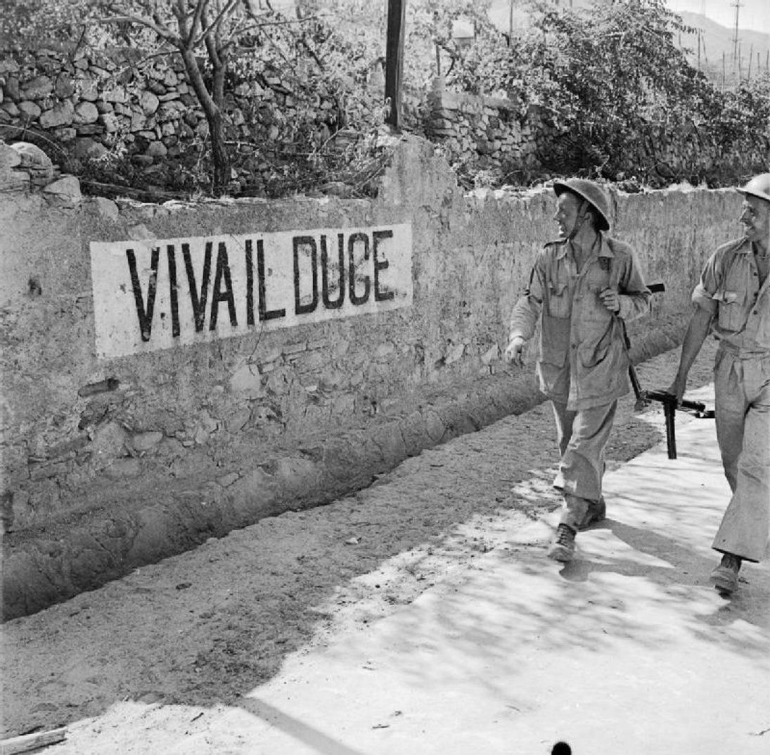
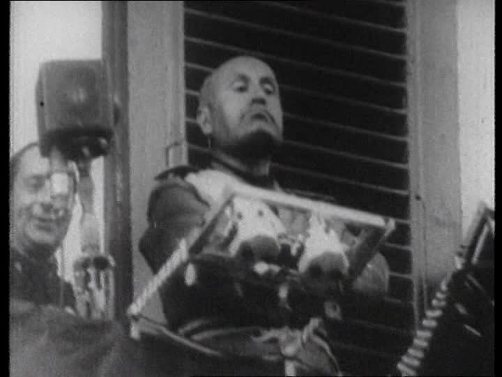
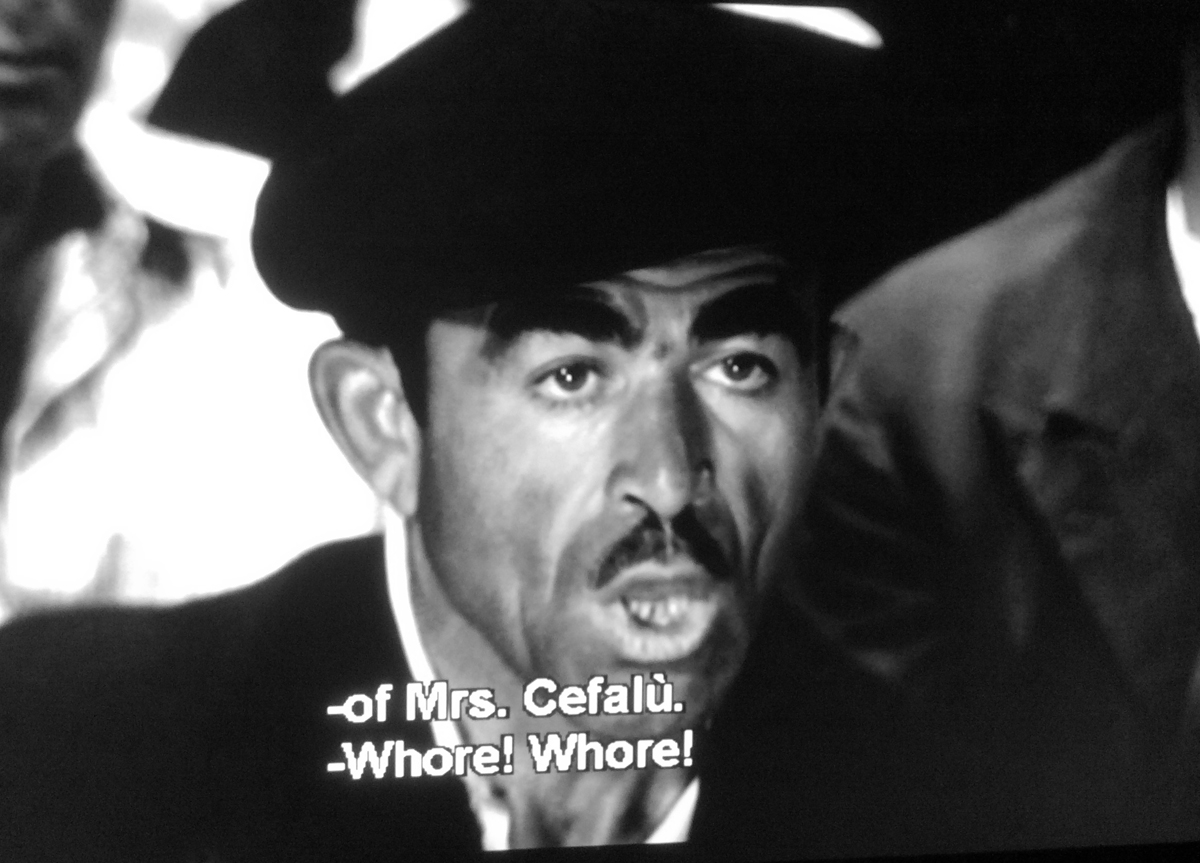
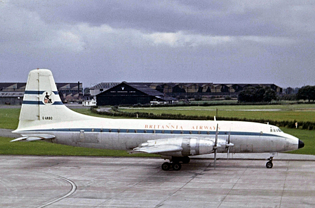
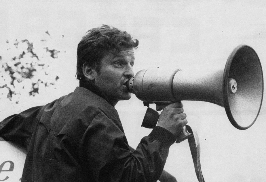
Peter Sellers, as Fred Kite, the militant shop steward, and Ian Carmichael in the Boulting Brothers “I’m Alright Jack”, based on Alan Hackney’s novel “Private Life”. – Have you been to Russia, Mr Kite? – No, but that’s one place I’d like to go. All them corn fields, and ballet in the evening.
From life in the wartime British Army (Private’s Progress, 1954), through to the New Towns of the 1960s (Let’s Keep Religion Out of This, 1963, filmed as Heavens Above) and the start of package holidays in Spain (Whatever Turns You On Jack, 1972) the novelist Alan Hackney had his finger on the life pulse of Britain.
Peter Sellers, with a Brummie accent, as the idealistic Rev. John Smallwood in Heavens Above, 1963, loosely inspired by Alan Hackney’s novel Let’s Keep Religion Out of This. The Rev. John Smallwood puts into practice the teaching of Christ, and in doing so upsets the local parish landed gentry, and causes panic and consternation in the national Church of England hierarchy.
His books are so spot-on in nailing the social history and the politics of the time – but luckily, also laugh-out-aloud (with the partial exception of Let’s Keep Religion Out of This) – that they should be on any reading list for first year students doing a degree in that social history/politics post war period of Britain. And watching Private’s Progress and I’m Alright Jack would save them tedious hours of skimping through some inadequate books, which partially miss (because they were written by academics – secure in their jobs and financially comfortably off, and some of whom were also influenced by their political leanings, left or right). Important aspects and commentary on what life was like for many were missed. For instance, Arthur Marwick’s British Society Since 1945 does not mention, even in one passing sentence, the desire of many Britons to escape the class stratification of that period and emigrate to Australia on the £10 scheme. Both the Kinks and the Animals touched on this stifling class ceiling in some of their music. And many Britons, encouraged by the Australian government took the boats heading out via South Africa and across the Indian Ocean to a socially freer continent.
Meanwhile, those of us left behind could go to the pictures on a Friday or Saturday night and bust a gut laughing at the films touched with the Hand of Hackney: Private’s Progress (1956), and I’m Alright Jack (1959).
Private’s Progress by Alan Hackney. Victor Gollanz, London, 1954.
Yet Alan Hackney rarely appears when book critics mention the likes of Angus Wilson, Kingsley Amis and William Cooper in the same breath. Still, I doubt that he would have been bothered. Financially he did alright. And the novelist William Cooper rolled around the floor laughing as he read his novels, and Evelyn Waugh did that rare thing (for him) and invited Hackney down to the Waugh home in Somerset, saying how much he admired his work.
Private’s Progress film poster for the United States market. Note “The Film That is Respectfully Dedicated to All Those Who Got Away With It”. This tag line was also used on the UK poster, and was the concluding dedication on the screen in the cinemas.
Not only do his books have a sharp view of what was happening in Britain at the time he wrote them, but they burst with brilliant dialogue, and the vernacular. The vernacular spilled over into film scripts that he contributed to that weren’t based on his novels, such as Two Way Stretch (1960).
Peter Sellers as Dodger Lane in “Two Way Stretch”, – ‘Ere, close that window, there’s a terrible George Raft.“Two Way Stretch”. Peter Sellers to conman Soapy Stevens (Wilfrid Hyde-White), pretending to be a vicar on a prison visit – What evil plan are you hatching in that disease ridden bonce of yours?“Two Way Stretch”, 1960. Left to right, Bernard Cribbins as Lenny the Dip, David Lodge as Jelly Knight and Peter Sellers as Dodger Lane in the Prison Governor’s garden.
The Film Censor giving Two Way Stretch a “U” – suitable for children – certificate didn’t notice that Alan Hackney had slipped in a choice phrase when Peter Sellers as the trustee Dodger Lane tells visiting welfare ladies in the Prison Governor’s garden that the giant marrow they are admiring was “Hand raised, as they say in the Navy”. There would have been an acknowledged titter in cinemas up and down the country, particularly from ex and serving serviceman.
Two Way Stretch UK cinema poster.
_____________________________________
His novels follow the lives of the same characters as they emerge from the war, such as the gormless Stanley, his naturist father, the unscrupulous, suave Brigadier Bertram Tracepurcel (Uncle Bertie), Stanley’s wartime mate Private Cox (Coxey) who after the war re-invents himself as “Mr de Cameron”, and then Fred Kite, Mrs Kite and Cynthia as they adapt, and some do very nicely thank-you, as Britain moves into the 1970s. The shop steward Fred Kite even makes it to the House of Lords in What Ever Turns You On Jack.
Alan Hackney, left, with Richard Attenborough, Peggy Hackney and baby Jane, and Roy Boulting, on the set of Private’s Progress.
In the obituaries for Alan Hackney when he died in 2009, the consensus is that I’m Alright Jack (“Private Life”) was the apex of his work with its merciless laugh-out-aloud dissection of trade unions super-glued to demarcation disputes and tussles with the Bosses and the Bosses looking after No.I whilst hypocritically spouting on about the “National Interest” (whilst lining their own pockets doing arms deals with corrupt Middle Eastern governments) and consciously provoking union militancy – strikes – for their own financial gain.
In fact, all his novels have an equal weight, but if one has to be highlighted besides I’m Alright Jack (“Private Life”), in the view of this writer it should be Private’s Progress.
The Awkward Squad, aka “Absolute Shower”, in their Holding Unit. Front, left to right, Ian Carmichael (Me Old Stan), Richard Attenborough (Coxey) and Kenneth Griffith (Jonesy). Back row centre Victor Maddern and Ian Bannen. Private’s Progress, 1956.
Here’s a novel (1954), and then a film made shortly after (1956) that appears in bookshops and then on cinema screens, wedged in between celebrations of World War Two British courage, and examples of individual daring-do. Films, often based on non-fiction books, such as Reach for The Sky (1956), The Dam Busters (1955) and Above Us the Waves (1955).
Skiver, buck-passer, and Major – Terry-Thomas as Major Hancock
Private’s Progress is a film that shows some Army Brass who are dodging and skiving as much as the soldiers they are commanding, and Army Brass who are involved in high scale looting of Art Works, shipped back to Blighty for private re-sale and their own financial gain.
High-end looter and Brigadier, Betram Tracepurcel (Dennis Price) and collaborator/girlfriend ATS Prudence Greenslade (Jill Adams).
“Shipped back” should perhaps be more accurately called “air-lifted”. There were elements in the RAF Transport Command and the USAAF equivalent who were assisting in flying back high-end loot.
The film’s dedication to “All Those Who Got Away With It” would have included British army soldiers who held Prince Friedrich Ferdinand of Schleswig-Holstein-Sonderburg-Glücksburg, his family, and their servants at gunpoint in the courtyard of Glücksburg Castle near the border with Denmark in May 1945. They were searching for Heinrich Himmler and looted the castle at the same time. Easily pocketable items with high value such as jewellery disappeared. The British Daily Mail in May 1945 reported that “The Duchess of Mecklenburg had appealed to the King (George VI) for compensation… ‘I wrote to Queen Mary in England who is my aunt, asking her to help me and she replied she would do’.” It’s not clear whether any of the soldiers, which would have included officers were ever detected or disciplined, and most of the jewellery seemingly was never recovered.
Duchess Cecile of Mecklenburg-Schwerin, 1886 – 1954.Prince Friedrich Ferdinand of Schleswig-Holstein-Sonderburg-Glucksburg (1913 – 1989)
In the film Private’s Progress Brigadier Tracepurcell and Private Cox and ATS Greenslade don’t get away with it, but in the novel they do, and they do very nicely too. The Boulting Brothers being realistic, knew the British Board of Film Censors would not allow the “culprits” to get away with it, and would refuse a certificate, and the film, therefore, wouldn’t get shown in British cinemas.
Richard Attenborough in The League of Gentlemen, 1960.
It was for the same reason that in the thriller League of Gentlemen, 1960, ex-British Army officers, and a few Other Ranks having mounted a spectacular and successful bank raid – using skills learnt during their army war training – also didn’t get away with it. Talking in 1985, the screenwriter T.E.B Clark (Hue & Cry, 1947, Passport to Pimlico, 1949) stated that in his screenplay for The Lavender Hill Mob, 1951, Alec Guinness also wasn’t able to get away with it. “The censor would not have allowed it”, he said. This wasn’t copping out – it was knowing what was, and was not allowed. The British Board of Film Censors was a self-censoring Trade Body established in 1912, and down the years had had an informal and comfortable relationship with the British Governments of the day.
In the film, every one else in Private’s Progress either does get away with it, or finds dodges and skives to make their boring, drudge-ridden and pointless army life in the Holding Unit a touch easier.
One extraordinary sequence in the film, not commented on by reviewers (and not in the novel) is when Major Hancock (Terry-Thomas) skives off and leaves the Camp, and is seen entering a Picture House in the local town. The banner poster above the Picture House entrance shows that the featured film is In Which We Serve. In Which We Serve was a deeply felt film written and directed by its star Noel Coward, at a time – 1942 – when the tide had yet to turn for the wartime Allies. When Noel Coward was finishing the films’ script in late 1941 British military were having one defeat after another, and the storyline of In Which We Serve was based on the sinking of the destroyer HMS Kelly in the Battle for Crete – a ship commanded by Louis Mountbatten. Recognising a good propaganda film, it was actively helped by the British Government’s Ministry of Information, in providing service men, and promotion. “A classic example of wartime British cinema through its patriotic imagery of national unity and social cohesion within the context of the war” – Wikipedia entry.
In Private’s Progress the on-screen credits boast that the Producers had help from “Absolutely No-One“. Richard Attenborough was in both films. (1).
Richard Attenborough in his first screen role in In Which We Serve, 1942. Victor Maddern who’s a dodging private in Private’s Progress served in the British Merchant Navy, joining in 1943 at the age of 15. It would have been no picnic. Somewhere in England: In Which We Serve at the local Picture House. “A Stirring Tale of War Heroism.” Private’s Progress.Major Hancock has a sly shufti to spot he’s not being observed before he slips into the matinée at the Picture House. Private’s Progress.Major Hancock being guided down the cinema aisle. Private’s Progress.Major Hancock settles into his cinema seat. A stirring newsreel commentator is heard on the sound-track. Private’s Progress.Turning to his right Major Hancock happens to alight on… Private’s Progress.… Private Ian Bannen and his current girlfriend snogging, and in front, Jonesy and Victor Maddern. They are unimpressed by the stirring voice and words of the unseen newsreel: “The British soldier today is highly skilled and highly trained“. Private’s Progress.Turning to his right Major Hancock spots two more dodgers. Private’s Progress.Spotted, Stanley (Me Old Stan) gives the nod to a half- dozing Coxey. Privates Progress.Stanley and Cox try to make themselves invisible, as, despite the bored audience, the newsreel commentator soldiers on. Private’s Progress.
The following day Major Hancock has them on a forced route march, with full kit. Sweating as they march they are brought to attention by the Company Sergeant Major. Major Hancock addresses them. “You’re an absolute shower. Practically every man in that cinema was from this company.” Cox mutters “Including you, cock.”
Terry-Thomas is rightly associated with the “Absolute shower”expression, but it was Alan Hackney who used it, having first heard it from an irate Commanding Officer in India during the war.
Review quotes of Private’s Progress. (From the front pages of Alan Hackney’s third novel Private Life,1958 aka I’m Alright Jack.)Coxey (Richard Attenborough) mis-appropriating the ABCA class to explain to his fellow squaddies the various ways of dodging railway fares.
ABCA stood for Army Bureau of Current Affairs set up during the Second World War to “educate and raise morale” amongst servicemen and servicewomen. The railway dodges outlined by Coxey included the ATS dodge, that Fusilier Walter Morrison describes in detail, along with others not mentioned by Coxey, in Pete Grafton’s You, You & You: The People Out of Step with World War Two. (2)
In the three Boulting Brothers films based on Alan Hackney’s novels there are omissions, and, the other way around, narratives that are not in the novels.
Catherine introducing Stanley to one of her friends. Private’s Progress.
In the novel Private’s Progress there is a section where the Stanley character is posted to India, mirroring Alan Hackney’s wartime experience. The novel also fleshes out what is only briefly touched on in the film: the London wartime world of Catherine, Stanley’s sister – a world of artists pre-occupied with producing art that is “plastic”, a stressed female vegan, a hardened squaddie who swings both ways, a Quentin Crisp type character who can’t bear the thought of having to wear “that dreadful khaki” and two dodgy art dealers, one of whom manages to “disappear” following the confusion at Dunkirk. This strand is an important – and witty – narrative element throughout the novel.
The “disappearing” of soldiers – “posted missing – presumed dead” – following Dunkirk is also mentioned in the Afterword to You, You & You.
Both the films and the novels they are based on are equally good standing alone by themselves. Alan Hackney was closely involved in the films Private’s Progress and I’m Alright Jack, even though the screen credits are perfunctory. “From a story by Alan Hackney” does not convey that it is a novel.
Alan Hackney’s novels, in order – left to right – that they were published.
His Gollanz published novels have been out of print for years, though most copies – second-hand – are available at reasonable prices on abebooks. Faber and Faber in their Faber Finds series currently list Private’s Progress.
____________________________________
The same happens with Marcello Mastroianni appearing in a film that features another film he starred in: He’s the central character in Germi’s Divorce Italian Style (1961), and is shown making his way to the Picture House in his Sicilian home town where Fellini’s La Dolce Vita (1960) is playing, playing to a packed house despite a pulpit condemnation from the town priest. They’ve seen the film poster featuring Anita Ekberg and heard that the film is full of orgies.
Christmas 1946,Clydebank and Hogmanay 1946 Loch Lomond youth hostel
Bird’s Christmas Custard advertisement, December 1946. Pete Grafton Collection
________________
This material adapted from Len:Our Ownest Darling Girl – Letters between Mother and Daughter 1939 – 1950. Mother was Helen Bryers, Dad was Harry Bryers and their daughter was Helen (“Len’) Bryers.
Mum and Dad Bryers, 1930s.
Mum and Dad Bryers lived in a rented house in Coldingham Avenue, Yoker, near Clydebank. Dad was an engineer and Mum had been a seamstress.
Helen (‘Len’) Bryers, Photo taken in Victory Studios, Argyle Street, Glasgow, 31 October, 1944.
Their only child, Helen, known as “Len” to family and friends, had worked in the latter stages of the Second World War as a shorthand typist for the Ministry of Supply at the Royal Ordnance Factory at nearby Dalmuir. Still working for the Ministry of Supply she transferred to a similar post in Cairo in November 1945. She was almost 20. At the time there was strong Arab anti- British feeling in Egypt, and contempt for the king, Farouk. Occasional demonstrations and targeted explosions at British associated Cairo buildings were occasional irritants. Otherwise Helen (‘Len’) was living in the land of milk and honey- no food or clothing rationing for her. Back in post-war Britain Mum and Dad and millions of others were experiencing rationing harsher than it had been during the war. Bread, freely available during the war, was rationed starting in July, 1946. There was also an acute shortage of houses. The weather wasn’t that brilliant, either.
__________________________
Christmas Eve in ye old Home, 24 December, 1946.
I just couldn’t let this night pass without letting you know you are in our thoughts as always, our darling.
Christmas card from Mum and Dad to Len (Helen) their daughter.
Here’s the latest re. hoose.
“New Houses” Abbey National advertisment, Picture Post, August 5, 1944. Pete Grafton Collection.
I called at the B.S. (building society) yesterday to pay the surveyor’s fee and the under manager told me he’d just been getting a letter typed to ask us to call for an interview with the manager, so I made an appointment there & then for 3 p.m. today. Just as we were getting ready to go out, Mrs Rae from next door called for a loan of a pudding basin as they were just about to put their plum pudd. on to steam when the basin broke. I think ours must be what is termed “a well appointed” house for I was able to produce a selection of basins for her choice.
At last we got away in a ghastly thick fog and frozen roads. We saw the B.S. manager – very efficient & polite – who phoned up their solicitor for an appointment for us and we are to see him at 11 a.m. on Thurs. They evidently got a very favourable report from the surveyor. The surveyor reported that, with vacant possession the house would easily sell for £1,750 or £2,000, so you see honey, if we can get it in the region of £500 to £800 it w’d mean a profit for us anytime we sold whilst the present housing shortage lasts & that looks like being for many many years. (The housing shortage was anticipated during the latter stages of the war by the British Wartime Coalition Government – much housing had been lost in the Blitzes, and the V1 and V2 raids – and the first prefabricated home (prefab) was erected and occupied in London in the Spring of 1945. It is reported that by January 1947, a few weeks on from Mum writing this letter, 100,000 prefabs had been built. However, there was still a housing shortage, particularly in the bomb damaged cities of Britain, most of which also had crowded slum areas.)
Dad & self then went shopping and went into Masseys. (Glasgow wide provisions stores of the time.)
Interior of Massey’s Union Street branch, central Glasgow, circa 1951. Photo source Glasgow Evening Times.A.Massey & Sons shopfront, the 1930s. Somewhere in the Glasgow suburbs.Massey’s shop staff, Shettleston Road branch, Glasgow, circa 1932.
There was a huge pile of mince pies on the counter & Dad asked about them & the guy serving said they were only for registered customers & I said “He (Dad) doesn’t understand all about the difficulties of shopping, ha! ha! But I’m going on holiday and he’ll get to know.”
Dad said “Yes, she is going to the land of milk & honey”, and the fella said “Where is that” & I said “Cairo, Egypt” & that started it – he was recently demobbed and said if he hadn’t been married he’d have rejoined again so as to spend another 6 months in Cairo, which he says is a most exciting city & he liked it very much. Well, we jawed & jawed & he said “Oh! I must give you some of these mince pies as you are old Egyptian friends.” He made up six lovely mince pies for us! – so you see, honey, ‘agaun fit is aye gettin’. (‘A moving foot is always gaining things’.)
We hear on the radio tonight that a bomb exploded in the Anglo-Egyptian Club but no one hurt, thank goodness. Must stop now, my sweetie pie, hope Santa puts something nice in your stocking. It’s raining cats and dogs tonight, the weather is terrible.
Boxing Day. 26.12.46.
Just look at the day it is and we never got this away to you – yesterday just seemed to go in wee bits of cooking, cleaning and shopping. (Shopping on Christmas Day: Christmas Day in Scotland historically was not as significant as it was in England. As late as 1967 it was not a holiday for blue collar and shop workers in Scotland.)
We are just off to the solicitors to make arrangements re. his getting in touch with Mrs Mac’s chap – I guess she’ll throw a pink fit when she hears our offer in the region of £500 – £800! (Mrs Mac was the owner of their home, her name fore-shortened by Mum.) It was such impudence of her solicitor to try to stampede us into £1,200.
Our kitten, Hope, is really a pet and is growing like anything, he is creamy ginger colour & so clean and dainty. How do you like his name? It had to be something beginning with “H” as is our tradition & I thought “Hope” so nice & cheerful.
There’s cards in for you from Mrs Holt and Bob Getchel, I’ll forward them in separate envelopes. (Mrs Holt was a former pre-war neighbour from Dagenham, Essex and Bob Getchel was a U.S. serviceman the family had got to know during the war.) The mantlepiece is decorated with over 20 Xmas Cards we got.
Mum extreme right with her daughter looking up at her, front room, Coldingham Avenue, Yoker, Christmas 1944.
We got a most lovely aluminium teapot and silver jam spoon from Aunt Ena – they are really beautiful and just what we wanted. I got a tin of Bath Salts & tin of talcum from Joan Brandley, very sweet of her to send them. (Joan Brandley was a close friend of Helen’s and family friend) We intend to go to L.L.Y.H. at New Year – what am I to do with Hope? I’ll be running up here every few hours. (L.L.Y.H: Loch Lomond Youth Hostel. The distance between the youth hostel and the family home in Yoker was 3 miles.)
“Och! The sound of it!” Dewars White Label whisky advertisment, Picture Post, December 7, 1946. Pete Grafton Collection.
The day before Hogmanay. (Have been busy making up your parcel – slacks & bra. etc and am now dashing off with it to the G.P.O.)
Dearest and Best,
We are all well and happy, but busy, boy! I’ll say we’re busy! I’m writing this in the middle of a mouthful of lunch. I note all the splendid tips in your letter re. filling in my forms and shall act accordingly, after New Year my thoughts and deeds will be dedicated mostly to arranging my trip. (Mum was planning to visit her daughter in Egypt.) The days just now are so brief and meals so many.
We are going to L.L.Y.H tomorrow – both Jack and Dad stop at 12 so we shall be off soon after. (LLYH: Loch Lomond Youth Hostel. Jack was a young lodger.) Jack is thrilled to bits at the idea of the hostels and I’m going to get a membership card for him in town today – that is to be his New Year gift from Dad & self. Jack is really a lonely soul and has not much young company so he is enthusiastic re. visiting L.L. and yesterday put on the outfit he proposes putting on for the trip so that we c’d O.K. it – or otherwise; he has a camera and films so will try to get some snaps.
We’ll be thinking of you on New Year’s Eve and wishing you all that’s Merry. May all your dreams & wishes come true in 1947.
Your own ever loving Mum and Dad.
_______________
3 January, 1947.
The beginning of the year 1947 in The Old Home.
Our Darling Own One,
This is the very first letter of the year and the first one we received this year was from you – we are so happy you had such a wizard time at Christmas. We just got back from Loch Lomond Y.H. last night and oh! boy – what a time we had! It was one of merriment and fun from the time we got there on Hogmanay till we left last night.
“Group at Auchendrennan (Loch Lomond youth hostel) New Year’s Day, 1947. Mrs Mac is in Centre with Henry Lindsay at her back – that’s Henry’s brother in kilt next to me. The piper appeared playing a tune, he had walked all the way from Tarbert after playing all night!” Mum’s annotation on back of photo. Mum is on the left and Dad is second right.
Loch Lomond (Auchendrennan) youth hostel, circa early 1950s.
Jack was overcome by the Membership card we gave him and some of his Norwegian Pals propose coming over to Scotland for a tour during the summer and he is to get a bike in April so he will be able to make good use of the card.
Like ourselves, he thinks Auchendrennan is wonderful and quite admires Joan MacDonald and thinks she is so pretty “like a doll” as he says, she is certainly a bonnie lassie and as sweet as she is pretty, as I told him, however Jack is so shy, he just remained tongue tied.
Before the clock struck midnight we all (about 85) of us trooped out and Henry Lindsay listened for the Chimes (this was because a piper was playing loudly) then we all trooped upstairs where Mr. & Mrs, Mac (the wardens, surname fore-shortened by Mum, as she has done with the owner of the house in Coldingham Avenue) received us with ginger wine and cake, then we had dancing & singing then Dad, Jack & self were invited into the kitchen where the fun was terrific & later Mrs. Mac. invited us all up to their own flat, it is very nice and, my! what a party – Daddy kept saying it was the best for years, it was hilarious – even riotous with fun and singing and ended up with several prostrate forms lying around, a true Scottish New Year.
At the hostel (but not at the party) there was a party of students from the International Club. Mostly Indians and EGYPTIANS (Mum’s capital letters)) and, as is my wont, I made hay while the sun shone by talking to the nicest Egyptian I could see.
Our festivities were broadcast by the B.B.C. at 8 till 8.20 on New Year and this E. I spoke to was one of two picked to ‘say a few words‘ over the mike, and I found his name is Doctor (it sounds like this) “Kiellally” – however, I’m going to invite him & his girl friend down some night – she is studying social science at the University and lives at Danes Drive, Scotstoun. The doc. is awfully interested in my trip and we talked Egypt for hours and he says what a pity I can’t wait till June to go out as he is going then and would be delighted to travel with me. I bet he knows the ropes re. that journey. He says I could go via France without bothering with Cooks and there’s a regular service of ships once a week from Toulon to Alex or P.S. It w’d be exciting to go like that, the only snag being baggage and customs, but I guess I c’d manage. Cooks make one feel so helpless, it makes me mad.
Now what I want you to do pronto is to give me your views re. travelling via France, free from any agency, I know I don’t need a visa to get into France but if I travel on my own how shall I get a visa to get into Egypt? And what about inoculations?
Re. the house, Dad & I saw the solicitor as arranged and he suggested offering £750. He further said not to worry in any case as the house (with the present legislation) is ours anyway, but that it w’d be nice to buy as one’s own house.
I have the most ghastly feverish cold, the first in years so I sh’dn’t complain – but I do!
Keep well and happy own darling, we are loving you all the time. All the best in the world in 1947.
Cheers and love, Dad & Mum. xx
_______________________
“Len” with her Mum, Cairo.. Taken by a Cairo street photographer, July 1947.
Adapted From Part Two, Chapter One “Fresh and Innocent” of Len:Our Ownest Darling Girl
Part 8: The Cairngorms, Perth to Glasgow and a day and night hitch back to London.
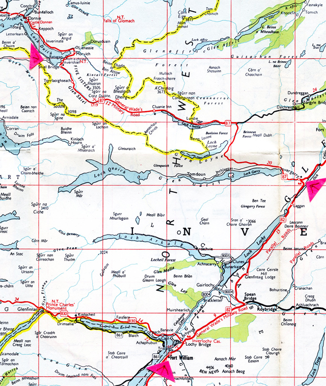
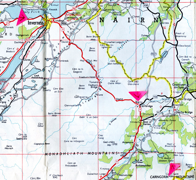
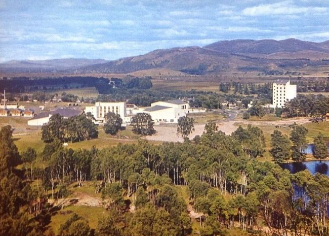
The Story so Far…. Walking Aonach Eagach. The Warden’s husband with a penchant for blokes. A Tiger in his Tank at Fort William and at Glenelg an old woman with rags for shoes and a hat for a pixie. Trouble brewing with the first Sabbath sailing to Kyleakin. Four free-wheeling young wardens in the Kyle of Lochalsh and Kishorn area. Fresh baked bread at Lochcarron. A bumpy ride to Inverness. Aviemore under construction and a Rank “Road Inn” at Loch Morlich.
To Come: Walking the Lairig Ghru Pass. Expensive mince and tourists in Braemar. All at sea Civil Defence on the start to Glen Doll. A street upset in Perth. Glasgow again and day and night hitching back to London, with a Freddie and the Dreamers look-a-like driving madly over Shap. The brand new automatic service ‘Transport Cafe’ at Forton Services, and a better one at the dead of night at the Blue Boar Services, Watford Gap. Trudging around London’s North Circular at dawn. Home.
The nice but maniac Freddie Garrity look-alike lorry driver. Photo of Freddie Garrity in America Stanley Bielecki.
________________________
June 4. Friday. Inverey YH, evening.
I thought the 24 mile walk from Loch Morlich to Inverey, via the Lairig Ghru Pass was going to be difficult, but it was O.K.
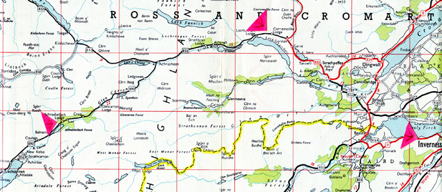
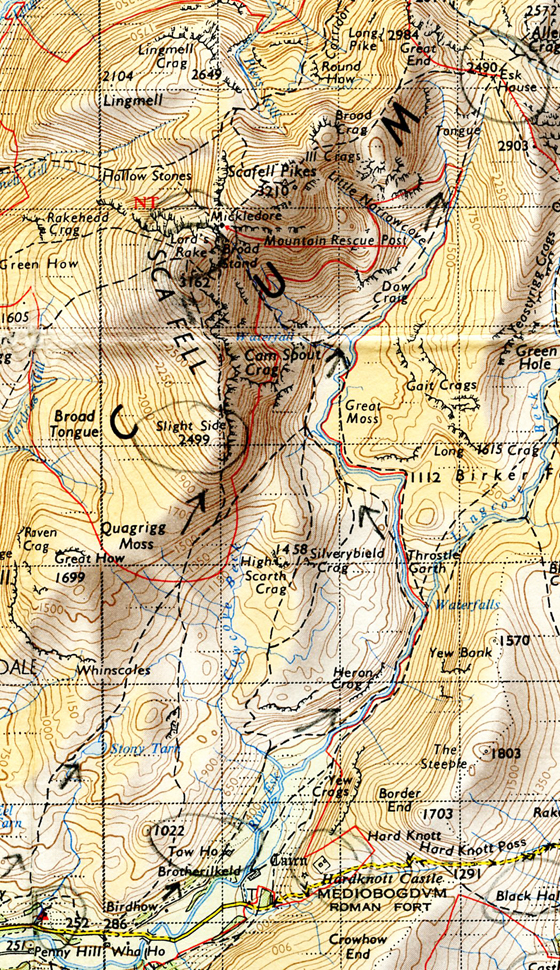
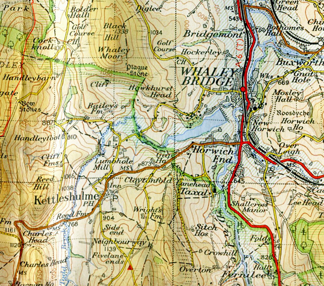
Loch Morlich youth hostel to Inverey youth hostel, via the Lairig Ghru Pass. Acknowledgement Esso Map No 7 Northern Scotland, 1962.Loch Morlich youth hostel – Lairig Ghru Pass – Luibeg. Acknowledgement Ordnance Survey One Inch Tourist Map of the Cairngorms, 1964.Lairig Ghru Pass looking south, from direction of Loch Morlich.
Leave YH around 9.30 a.m. Sun’s out but a strong wind and waves are choppy on the loch. Walk along by the loch and take the track making for the Rothiemurchus ski hut. It’s a moderately new track – white crushed stone. Walking along by this characteristic undulating heather area, and then gradually ascend the slope until you reach the hut. Although built in 1951 it’s an awful mess, made of timber and falling to bits. It’s a shabby, jerry built thing. And so the path that brings you onto the Lairig Ghru Pass path. Follows the valley, ascending slowly, sometimes by the burn, sometimes above it and then crossing over by the Sinclair Memorial Hut. Big scree slops on either side, towering up there. I’m going fast, making good time. Pass a party of school boys and their masters, ask the time – one o’ clock. There’s a couple of patches of snow as you get higher, blinded by the sun and the whiteness, one of the few times I wished I had sun glasses. After the snow there are lots of boulders – easy going though, jumping from one to another and unbelievably make the Pass, thinking – this can’t be it, must be further. But it is and there are the Pools of Dee.
Stop by them for a packet of biscuits, a cig and a rest. In front of me the valley descends gradually.
Summit of Lairig Ghru Pass.View from summit of Lairig Ghru Pass.The Pools of Dee, near the summit of the Lairig Ghru Pass
Big sweeping mountain sides coming down to the Dee. Continue after the biscuits, cig and rest. The mountains on my right getting more definite in outline, especially Cairn Toul – snow capped and some interesting, beautiful shaped corries high up at around 4000′.
Cairn Toul, 4241′.
As you start descending from the Pass and look back you see Braeriach and in its corrie what looks like a small landslide, or scree, shifting.
Braeriach, 4248′.
Come to Corrour bothy hut on the other side of the river, and this is where I branch off. following the slope of Carn-a’ Mhaim.
Corrour Bothy and Cairn Toul. Acknowledement Ordnance Survey One Inch Tourist Map of the Cairngorms, 1964.
A party of oldish nice looking, blouses open schoolgirls pass me on the path, we exchange ‘Hellos’. They’re led by ‘Sir’ who gruffly tells me it’s 3 o’ clock when I ask him the time. Onwards now in Glen Luibeg.
Glen Luibeg to Inverey. Acknowledgement Ordnance Survey One Inch Tourist Map of the Cairngorms, 1964.
Looking back it looks like a hanging valley coming out into Glen Dee. Desolate, wild, barren rolling hills around here. Sun’s gone in but it’s still warm. When I come to Luibeg Bridge it is washed away, part of its concrete foundations lying in the boulders of the river bed. There’s a lot of boulders in the river bed – must be quite a torrent during the melts. There’s a new bridge further up the tributary valley but I decide to ford the stream, being told last night by two blokes in Loch Morlich that you couldn’t. They’d done the route from Inverey yesterday. It wasn’t a problem, so not sure what they were on about.
Along the valley until it starts to get wooded on the slopes, and on down to Derry Lodge.
Derry Lodge, a missing bridge and Inverey youth hostel. Acknowledgement Ordnance Survey One Inch Tourist Map of the Cairngorms, 1964.
There’s a big herd of deer, lots of stags, on the other side of the river. They look at me, undecided, move away slowly and as I go past on the other side they move back. Cross the river by the bridge at Derry Lodge and continue walking along the glen, now called Glen Lui, and thinking about Sima and Shula, Israel, and going out to see them and before I know it I’m coming up to the bridge that crosses the river. There’s pine forest on my left. There’s a couple with camera and binoculars and they ask me if I’ve seen any deer – “Yea -two miles down”. “That’s a long way, isn’t it” they say. “Well, that depends”, say I.
Continue until I reach the road near Linn of Dee.
Near Inverey. Pre-1914 picture postcard.
Make for the bridge, some tents pitched on the common, but when I get there it has also been washed away. Cheesed off as I contemplate having to walk right round Muir, but think – blow it. I retrace my steps and cut down to the Dee through the wooded slope. Wander up and down until I find a place I reckon I can ford. This time I need to take off my boots and socks and roll my jeans up above my knees. Socks stuffed in my boots which I’m holding (no room in the rucksack) I wade in. Water’s not as cold as I expected, but the rocks, pebbles and boulders in the river are slippery and hurt my feet. Move slowly across, water up to my knees, strongish current, until I reach the other side. Feel stupidly pleased with myself as I put my socks and boots back on, cut through the wood, make the road, trot down it. Stop by the first cottage, not sure whether it’s the hostel, move along to the next cottage and yes, it’s the hostel.
Enter. The oldish couple with car, the bloke wearing a kilt, who were at Loch Morlich last night are here, and a young couple who were at Glen Nevis on Monday night are also here. Dump ‘sac, go along to the warden’s house and pay my overnight 3/6d fee (17 p), and return to the hostel. Great hostel – must be the smallest in Great Britain – 14 beds. Nant-y-Dernol, Black sail – 16 beds. Beautiful stove – hot oven. Cook pleasant meal for a change. Talk to the young couple – they’re from Croydon, he’s chairman of the Croydon YHA, he gave references for Anne – small world. The girl’s nice, nice and fruity.
The hostel’s on open common ground by the river, there’s trees, big patch of grass and some campers are in tents out there. Two girls barge in – “Is this the key for the bogs?” Tarts. They take it, go in the bog and probably fix themselves up for the night. I eventually go to bed. Outside you can hear people moving around, trying the back door. Fuck ’em. Sleep.
________________________________
June 5. Saturday. Braemar YH. Evening.
Woke up this morning and sitting in bed patched my jeans by ingenious method of cutting a piece off one of the back pockets. Jeans patched, arse’ole presentable I emerge and have breakfast, porridge minus milk – haven’t had any fresh milk for three days. Bad. Raining heavily outside.
Leave at 10.30 when the rain had dropped off to a steady drizzle. The young couple from Croydon ahead of me, catch them up, walk together for a bit, then leave them as I cross the bridge over the Dee.
Inverey youth hostel to Braemar. Acknowledgement Ordnance Survey One Inch Tourist Map of The Cairngorms, 1964.Inverey youth hostel to Victoria Bridge over the Dee and Mar Lodge. Acknowledgement Ordnance Survey One Inch Tourist Map The Cairngorms, 1964.
Boring walk through parkland, the drizzle eventually eases up
Mar Lodge, between Inverey and Braemar. Pre 1914 picture postcard.
Eventually come to Invercauld Bridge, which is two miles further on from Braemar, on the north side of the Dee.
Invercauld Bridge, near Braemar.View from Invercauld Bridge. Pre 1914 picture postcard.Invercauld Bridge and Braemar. Acknowledgement Ordnance Survey One Inch Tourist Map The Cairngorms, 1964.
Cross the bridge and walk along back along the road into Braemar, past a vile looking Braemar Castle, open to the public 10 to 6, and it looks about 60 years old.
Braemar Castle. Circa 1920s picture postcard.
Into the craphole that is Braemar – there’s fuck all to it. Mostly Victorian hotels, gift shops and coach loads of old people. There’s nothing else – no beauty to it, no age, so why all these tourists, all these hotels.
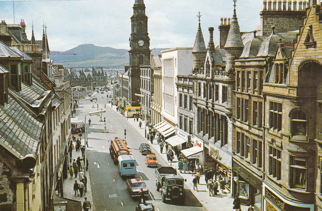
Braemar, 1960s. Bristol cigarettes and Capstan. “Fancy Gifts”, and a Post Office Land Rover.
The scenery around here’s OK, but it’s not that great. Withdraw £10 from the P.O. and sent a postcard to the warden at Glasgow YH, after buying some food – including ½lb mince that cost 2/4!!. (11p). Me walking out of the butchers murmuring with great feeling “Robbing bastards”.
Walk a bit out of Braemar, going south, past the awful looking Victorian hostel, along the main road with deer fence each side until I find a tight space to sit down behind a crumbled down stone wall on the roadway, deer fence a foot away and eat wads of bread and jam whilst cars zoom past. Eat too much.
Looking down on Braemar
Guessing that it’s around 4 I walk back to the youth hostel.
Braemar Youth Hostel.
It’s full of jerks, and when it’s like this I can only agree with Willie about hostels – hostels are OK, it’s the hostellers who are a problem, is the way he put it.
A party from South Shields – 3 blokes, 3 birds, 2 cars, one pair of skis, one of the blokes a ponce. But to top it all a S.J.P. (School Journey Party), with a woman teacher who’s got no sense. They take over the self-cookers, and each took a frying pan to fry 4 sausages, when they could have fried the lot in two pans. Masses of lard spitting all over, the place a mess, and everyone else – including me – having to wait until they’ve finished and cleared out. I cooked the mince and had it with spuds, and it didn’t taste bad. (The grudging acknowledgement from Le Patron that it was O.K. was not surprising. Being ignorant, he wouldn’t have realised that the bought in Braemar mince was probably prime Aberdeen Angus, and worth the extra pennies to spend on it.)
More people arrive, amongst them Americans and a young couple with children. Oh accursed hostellers. Sitting at the table after my meal are the young couple, who are touring around in a car. They’ve put their kids to bed, and the bloke has got his National Benzole map spread out all over the table, over my things, and keeps disgustingly sniffing all the time as he pours over his map, mouth half open, looking mental, and these deep, take it down the throat, green snot sniffing, until I feel like smashing his face in. Which of course I didn’t.
National Benzole petrol.
_____________________
June 6. Sunday. Morning.
A foul night. Small dormitory – too many blokes – that bloke sniffing, people snoring, stuffy, couldn’t get the window open. Yes Willie, you’re right about hostels being OK, and hostellers being the problem. Not all, though. The answer is be independent – a new tent, sleeping bag, a paraffin stove and Bob’s your uncle.
Gladly left the hostel at half past nine, and oh gladly walked away from it along the main road until Auchallater Farm, the glen getting more definite as I walk. Opposite the farm where the track starts for Glendoll there are a couple of Civil Defence lorries parked. As I cross the road and walk past them a bloke asks “Are you going to Alpha?” – “Do what?” – “Are you going to Alpha?” What the hell’s he going on about. “Have you got a map?” he asks. “Yea.” – “I’ve got a better one in the lorry, I’ll show you where Alpha checkpoint is.” He shows it to me. The map’s the same as mine. Then I point out I haven’t got the faintest idea what the fuck he is talking about. – “You’re a scout aren’t you?” – “No.” – “Ah.” I trot off after he tells me Alpha checkpoint is a good 3 miles down the track, when it’s only 2. Can you imagine after a nuclear attack relying on these people to organise anything? (In the early to mid 1960s Civil Defence seemed to be mostly involved in training for preparation for a post-nuclear Britain. As the Beyond The Fringe sketch of the time wittily put it, in an answer to a question from Dudley Moore (in a pre Pete and Dud voice) about when normal services will be resumed after nuclear attack, a plummy mouthed Jonathan Miller replies “Fair question, fair question. I have to tell you that it will be somewhat in the nature of a skeleton service.”)
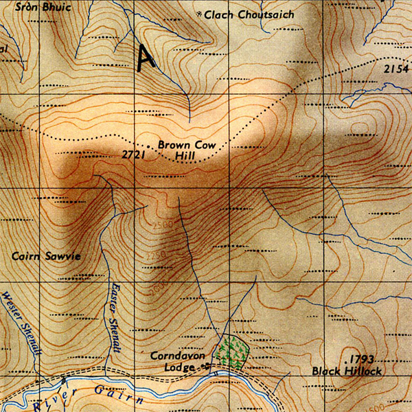
Braemar youth hostel to Glendoll youth hostel. Acknowledgement Esso Road Map No. 7 Northern Scotland, 1962.Braemar youth hostel – Auchallater Farm – Loch Callater – Tolmount. Acknowledgement Ordnance Survey One Inch Tourist Map The Cairngorms, 1964.
The track along the Callater Burn is easy walking, scouts pass me every now and then, part of this exercise. Come to Lochallater Lodge which I presume is a shooting lodge. Stop and have a cig and then walk along the loch, steep hill side tumbling down and continue to follow the path up the glen until I start branching off to the left, by a broken signpost saying ‘Footpath to Glendoll’.
Start to climb up to near the summit of Tolmont, at the 3014′ point. I meet three scouts on their way down. It’s a sharp gradient as I climb. I stop, start, panting and suddenly, there I am, unexpectedly on top when I thought I had farther to climb. Roll a cig and look around. Incredible plateau top, the first I’ve seen in Scotland.
Tolmount to Glendoll youth hostel. Acknowledgement Ordnance Survey One Inch Tourist Map The Cairngorms, 1964.
Someone comes up behind me, hadn’t noticed him. Older bloke with Dartmoor cropped hair and turns out we’re both going in the direction of the hostel, so we set off together. Notice a big boulder with ‘Home Rule for Scotland” painted on it as we walk along. It’s a straight-forward walk down Glen Doll. He shows me where when it snows it can pile up in 50’ drifts, and a plaque to the memory of 5 hikers who died in a blizzard New Year, 1955. So what seems an easy going glen can be very different in winter. Reach the hostel and put off by the number of cars parked outside, but it turns out it’s a SYHA work party. Go in, it’s an ex-shooting lodge.
Warden not in, make myself at home. When she does come in she’s a young at heart warden. Sign in and buy some food from the hostel store. There’s also a couple of elderly English touring around in a car, a Swede and a Scot in kilt with a dirty long whispery grey/white beard. The working party left soon after I arrived. It’s a nice hostel.
___________________
June 7. Monday. Perth YH. About 7 pm.
Whit Monday in England, but just a day here. A big breakfast of 3 bowls of porridge with sugar and sterilised milk which the warden sells at the hostel. The hostel’s in a good situation, up here at 1000′, at the head of the glen. Very green, plenty of trees, the mountain-sides sweeping down to the valley floor.
After taking empty crates of orange juice outside bought six heavy ones back in to the hostel, my duty, and then was off.
Walking down Glen Clova – quite a beautiful, green U shaped valley, a few farms – a coach load of kids passes me going up the road to Glendoll. I continue down the glen, Clova further than I thought.
Glen Clova.
Stop and sit on a rock and drag on a fag. Coach returns empty. I look up, coach driver points down the road, I nod. He stops. Great. I get in. Nice driving along in a big modern empty coach, sitting up front next to the driver, driving down to Kirriemuir. The scenery’s getting smoother, rolling hills, lowland and very green. Hedges, fields, ploughing. Kirriemuir is on the plain. Flat around here, not a mountain in sight and a lot of council houses.
Kirriemuir, circa early 1970s.
Driver drops me off just outside Kirriemuir, and as he told me, was continuing up Glen Isle, up the Devil’s Elbow and on to Braemar where he’ll pick the party of school-kids up. Walk back a bit into the town. Into a shop and out with dinner – packet of biscuits, date bar and a 1lb of Canadian honey. Walk back out, past the garage on the corner, out into the country. Not many cars. Eat the biscuits and dates, hitch the occasional car. Spend some time there, then as a Vivia (Vauxhall Vivia) zooms round the corner I hitch and he slams the brakes on. It jolts to a halt, I run down the road, rucksack banging, get in and off we zoom. Got quiet a lot of power those cars.
And then I have a horrible feeling I’ve left my map case on the verge. (These map cases were ex-WD cases, usually from the Second World War, bought in Army Surplus stores.) Feel behind the seat and feel it’s strap. Am I relieved. Driver’s some sort of rep – nice bloke. Notice going dirty white shirt sleeve cuffs, slightly frayed. Tells me about the fruit around here – black currants, etc, that are grown and bought by Chivers, Robertson’s. Tells me about what happened when the ferry went over to Skye last Sunday. Apparently 8 were arrested for obstruction as the cars came off the ferry at Kyleakin. A minister got arrested. I can imagine Fred and Willy going over on the ferry out of interest, Willie drunk and shouting at the protestors about religion being the opium of the masses. That would have made him popular.
No sailings on the Sabbath protest, Kyle of Lochalsh – Kyleakin ferry, May 30, 1965. Photo source Glasgow Herald.
The driver drops me off at Blairgowrie. He’s off to Dundee.
Blairgowrie, 1960s.
Sun now hot. Walk out of Blairgowrie on the Perth road. Stand by a golf course. Bloke with shoulder length blond hair is cutting the grass with a lawn mower. On the other side of the road there’s temporary built asbestos sheet houses, and a woman with a small kid in a push chair waiting by the wooden bus shelter. I’m just up from a bend where cars come zooming round and then roar down the straight. It’s hot. Smoke a couple of cigs. Hitch, but no go. Opposite, bus comes, mother and child get on, and off it goes into Blairgowrie. Hitch, but still no go. Perth bus comes – yellow Northern bus – it stops, some kids get off and with a “Will I? Won’t I? – Ah fuck it” I run up and get in. 2/5d (12p) to Perth.
Blairgowrie to Perth. Acknowledgement Esso Map No.6 Southern Scotland. 1962.
Watching the driver slowly chewing in the reflection of the window where I’m sitting. After travelling through flat green countryside arrive in Perth. Perth. Pleasant enough, although still very hot. Stacks of school children around, it’s just turned 4. School girls trying to look fetching in uniform. Actually, there’s something pleasantly provocative about 17 year old girls in school blouses and blue skirts and satchels. Yes.
Perth, late 1950s, early 1960s.
A long trek to find a bakers, but when I find one no brown bread. Directed up a side street, that also sells milk. Two women, middle-aged, possibly pros (prostitutes) are crying and screaming at each other, one in trousers, cotton tee shirt, long straggly dirty flaxen hair, crying and waving her arms and saying “I’ve had enough”, and her mate trying to restrain her – she’s also crying, wearing a red 1949 type cut suit. The first one pulls away and goes in a telephone box. People stand on the sidewalk looking, shop keepers come out and look. A bloke slowly dragging on a fag. Some watchers are smiling, others have blank expressions. No-one seems concerned.
Hot sweaty walk up to the YH. Along a short drive off the main road, after a lorry driver passed me, leaned out and pointed up the drive. I nod. Victorian house but peculiarly pleasant inside.
Perth youth hostel in winter.
It’s slightly on a hill and looking out of the big windows at the front there’s a view of Perth. 2 Australian women, a sour faced Scot, 2 Scottish girls, a Scottish bloke who’s boring, and tries to get in on everyone’s conversation. Spent a lot of the evening talking to the Australian women and the oldish bearded relief warden.
_________________________
June 8. Tuesday. Perth YH.
Still early morning but it’s incredibly hot – probably going to be the hottest day so far this year. There’s a misty heat haze over Perth and the slate roofs are shining a brilliant white in the sun. Television aerials, spires and buildings.
Perth and the new road bridge over the Tay. 1960s.
A Glasgow Corporation park, around 12 noon. Burning hot, sitting on a green painted bench. So hot you can smell the paint, even though it’s old. Boating type lake in front of me. Several people sitting on the benches, or wandering around, main road outside, heavy traffic. (This was probably Haggenfield Park.)
Left hostel 9.30 am, walked along the road and pursuing a policy of hitching everything it worked – a Jag stops, 1959 type but well kept, shiny black, automatic transmission, feel it pull under you. Quiet engine, sun roof open, radio on. Cruising through the sun burning countryside – very green and somehow foreign, could easily be in Germany or France and strangely there happen to be Mercedes and Fiats passing us on the other side – and even a continental train crossing with the bars up and the warning notice that are all over the continent.
Cruising along, driver’s OK, but says little. Going to Manchester – Jesus what a lift, if I wasn’t stopping overnight in Glasgow. Go through Stirling. Look out at a girl on the pavement, she turns her head and smiles back. If I had an E Type I couldn’t go wrong.
Jaguar E Type. Photo source and acknowledgement Autocar. No photographer I.D.
He drops me off on the outskirts of Glasgow and continues for Manchester. I walk in a bit, and come across this park by the main road. Write this, and will find a bus stop in a moment.
Glasgow YH Yeah-hey. I’ve got the job as assistant warden. Although I sometimes thought I didn’t want it, now I’ve got it I’m looking forward to it. It’s a dusty old hostel – the Glasgow dirt. Got a small, rather dingy room in the finance office cum annexe 2 doors along. Top floor, looking south and a magnificent view of the city, should look great by night. Warden hearing I can do posters wants some for the hostel – directions for where the self-cookers are, common room, dormitories, etc.
So, from the park. Decided to walk into the centre rather than get a bus as still mid-day. Hot, hot day and Glasgow’s a dirty city, but a nice dirty city. Seems to be a lot of poverty – dirty and soiled clothes, dirty tired faces. (Le Patron was walking through the East End.) Bloke’s in boiler suits, women, kids, a few bomb sites, pros, big black dirt grimed tenements. Get to the centre and big shopping streets. Down Sauchiehall Street to Charing Cross. Only 2, walk further on. And remembering that Glasgow has no bogs, I come across one, for Gents only. Green painted iron railings, on an island, circular staircase winding down to it. Have a pee and ask the attendant where the nearest Ministry of Pensions and Insurance office is. Maryhill, he says. Uh-huh, and it’s quite a walk, dropping into a tobacconists, asking if I was near it. “Aye well, you’ve got a wee walk yet” and given directions.
Made it. Exchanged my card, just like that – no comments or questions about why it’s only got 20 stamps in it. Wander around until four, then go up to the hostel in Park Terrace – get the news, shown vaguely what I have to do, then upstairs to their quarters and a cup of tea. Then to next door and the room I’ll be sleeping in and a clear out. My Struggle by Adolf Hitler and Albert Moravia’s Two Adolescents in a drawer. Carpenters have been in to replace the window. Swept out all the chippings and filings but can’t get the window open.
_______________________
June 10. Billericay.
Billericay, Essex. 1960s.
Got a lot to catch up on and try and remember. Left hostel around 8.30 am, and decided to get the bus to Rutherglen – the warden had suggested that as the best way to start hitching south. Warmish cloudy morning. A lot of people around and traffic, all going to work. Walk to George Square and can’t see bus stop for Rutherglen.
George Square, Glasgow. 1960s.
Go into the Information Centre. “Get a No.18 in Argyll Street” bloke says. Find Argyll Street and the bus stop and get the No.18 to Rutherglen – outskirts of Glasgow.
Not much chance of a lift so start a long walk out to Hamilton, hitching as I do. No go, walk, hitch, no go. I’m standing opposite a school, iron railings. Derelict expanse of ground, weeds, pylons, industry and houses in the distance. Now very warm. A woman waiting at a bus stop opposite. Hitch and at last my first lift. Bloke in an Anglia, going to his office, takes me out of his way onto the Carlisle road the other side of Hamilton, youngish bloke who’s done camping, hiking in his time.
Ford Anglia. Photo source and acknowledgement Daily Telegraph
Don’t have to wait long. Hitch and get a lift to Carlisle in a brand new sky blue Morris van, youngish bloke – some sort of photographic salesman, only I mistook him for an engineer. Van pretty filthy. Doing a steady 40 back along the route I came into Glasgow by. Driver going to New York for his holidays, taking wife and kids, got relations over there. Seems to be making some money. Carlisle about 2 o clock.
Carlisle, 1960s.
I get dropped off at the same spot I was dropped off when I hitched from Cockermouth in May. Into that small round bog where the cars are parked. A pee and a walk through Carlisle – about as hot as it was when I did the same walk to hitch to Penrith. Walk out of Carlisle, sit on that bench by the big ad. board and eat a packet of biscuits. Walk on, past the garage, and hitch. No go for a time then a lorry pulls out of the garage, just misses hitting an office. I don’t hitch but driver indicates down the road. I nod, he stops, the Austin behind nearly going into the back of him, and overtakes with an angry blast on the horn. Driver and his mate. “Where yer going?” Penrith way, I say. He tells me to climb up into the back of the lorry, low-loader. I’m thinking he’s only a local lorry, at first it’s OK but when he picks up speed slate dust starts whirling around, blowing in my eyes. Keep my head down, eyes closed – and oh, what a driver.
Really belting that Morris lorry along, getting impatient when he gets behind a lorry and can’t overtake. Feel the engine, hear the engine start up for a spurt, then relax, start up, relax. Get stuck in a jam in Penrith. Driver’s mate leans out the window. “Where yer going?” – “Lancaster”, thinking they’re not going further, “Well Manchester, actually.” Mate talks to driver then leans out. “Here”, he says, “get in cab, we’re going there.” Oh, fucking great.
Get in cab, sitting on the engine, my back to the windscreen – driver puts a heavy coat over the engine as it’s pretty hot. “Aye, we’re going past Manchester, Sheffield way.” says the driver. He’s a youngish bloke, late 20’s, early 30’s, black curly hair, rough textured face, oily almost, needs a bit of a shave, wearing glasses. He looks like Freddie of Freddie and The Dreamers.
Freddie Garrity in 1965.Freddie at the wheel. Believed to have been taken whilst Freddie and the Dreamers were touring in the U.S. photo Stanley Bielecki.
He’s sun-tanned, tattooed arms on the wheel, his mate, Pop, old bloke, wearing a sweat rag. He speaks. “‘Ee, it’s fooking marvellous up here, eh?” They’re great blokes. Been out 2 days, delivering a load of slate to Carlisle. We belt along and then get stuck behind a lorry and trailer on Shap Pass.
Looking up Shap Pass. Before the motorway this was the main road – the A6 – into Glasgow and Scotland from England. Going down the other side there was a sliproad for runaway lorries. Photo circa late 1950s, but would have looked the same in 1965. Note the ‘phone box in the lay-by bottom left for drivers with problems. This ‘phone box is not seen in earlier photos of Shap Pass.
This is Shap – a narrow road with bends. Driver: “Look at that fooking lorry, fooking hell.” Then makes a break for it, gripping the steering wheel, the engine revving madly and start to overtake, driver jerking backwards and forwards frantically in his seat trying to make the lorry go faster and pass the wagons before he smashes into something coming the other way. We make it, but bloody hell. Pop hands Woodbines around. Then he hangs a damp dirty white shirt out the open window to try and dry it. Crazy. We’re now on the M6, belting along, Pop hanging his shirt out, hanging on to it for grim death, hauling it in every time we pass a lorry, clicking of lights lorry to lorry as we pass and pull back in.
Forton Services, on the M6 just north of Preston. Circa 1965/1966. Photo acknowledgement tpbennett.com
Pull off the motorway at a newly opened Rank cafe. (This would have been the newly opened Foxton Services, between Lancaster and Preston. Wikipedia says it was opened in November, 1965, but it was open in June, 1965. November may have been the official opening. The nearest other M6 motorway stop in Lancashire was run by Forte.) It says above one entrance ‘Transport’, so up we go, up the stairs and go on in. Transport? Everything’s money in a slot to get your food. You have to buy your tea from an automatic machine – 6d. I go out and down, to buy some Woodbines. Go in the bog – Christ, I look like a coalman – face black, from the slate dust when sitting in the back of the lorry. Buy the Woodbines from yet another automatic machine. Coaches in, coach crowds. Back to the cafeteria, the so-called ‘Transport’ section. They’re sitting there, looking suspiciously at all the ‘nice’ dressed people. Join them and hand round the cigs. “Ee, this is a fooking place, 4/- for fooking salad.” We get egg and chips for 2/- but a slice of wrapped bread and butter is 6d. Fucking robbery.
There’s a bloody stupid woman going around, sort of manageress, going around asking everyone if their food’s alright. Comes to our table. “Everything alright, sir?” It’s fucking ridiculous. Pop looks at her as if she’s from outer space, but doesn’t say anything about the prices. None of us do, sort of shifting around uneasily in our seats. I nip out to have a wash and brush up. Run across to the lorry. Climb in the back. Rucksack’s covered in black dust. Take out my towel and washing stuff.
Into the washroom. Spend a couple of minutes trying to work out how to get water out the tap. Start to dismantle the tap when a bloke comes in, starts to wash his hands, can’t see where the water’s coming from. Ask him. He indicates the floor. A-ha. Underneath the sink there’s an oval rubber thing you press with your foot, and it works. Wash. Return to lorry, cleaner. They return. Check oil. There’s a lorry parked next to ours, artic with a J.C.B going to Staines. Driver tells me to go and see its driver. Do. – “Are you going to London? Could you give me a lift?” – “I would, yea, but I’m not allowed to.” Fair enough. I get in our cab. Artic. driver comes round to inspect his back tyres. Talks to my driver. “No, I can’t take lifts, we have spot checks, insurance, you know.” They have a friendly chat. Artic driver: “Burnt my breaks coming down Shap.” – “Did you?” And then we’re off again, belting down the motorway.
I’d be wondering if I should get dropped off to where they’re going on their way to Sheffield, but decided to get dropped off when they turned off the motorway at the Manchester turn-off. I do. Friendly waves and thumbs up all round as they pull away. Good blokes.
I’m where the main Manchester – Liverpool road passes underneath the motorway approach roads. Plenty of traffic. Get my fawn socks out of the ‘sac and start to brush off the dust. Got most of it off when Anglia stops. I look up. And get a lift. Within 5 minutes. Great. Quietish bloke going down to South Wales. Dropped me off in Wolverhampton around 8 pm. By now I’ve decided to push on regardless.
Road network in the Wolverhampton – Birmingham area, 1965. The M6 north of Wolverhampton stops at Dunston. No London bound motorway out of Birmingham. Acknowledgement Esso Map No.4, Wales and Midlands, revision 1965.
On Birmingham road – built up, factory type area. Birds dolled up for the evening. Cars with young couples. Hitch and green Ford Prefect stops. Irish chap – looks like a typical Irish labourer – and there is such a thing as a bloke looking like an Irish labourer. Quiet, soft spoken. It’s all built up between Wolverhampton and Birmingham. Drives carefully. Pleasant chat – he’s a ganger for Wimpey. Just about to cross some lights and they turn red and he protectively puts a hand out over my chest as he brakes to a halt. (UK car manufacturers had to fit seat belts from 1967 models onwards, but it was not compulsory to use them until 1983.) Drops me off outside Birmingham, apologising he can’t take me further.
Hitch and a new dark green Zodiac stops. Youngish well dressed smooth bloke, smelling of aftershave. Must have plenty of money as he gets 8 gallons put in the tank at a petrol station. Goes out of his way to drive me to the other side of Birmingham. Now getting dusk, even though it’s only 9.15 pm. Go through the centre that’s called The Bull Ring and surprised me – all mod, underways, overways, looks really mod, lights, colours. Yes, I like it, then back to industrial areas. Drops me off near a sign that says ‘Birmingham Airport 5 miles’.
Start walking. Past a bingo hall around 9.30 pm. Women, nearly all women pouring out, some to get buses, others being picked up by their husbands. Keep walking. A couple of cubs (Junior boy scouts) ask me where I’m going. Walk on and on, never-ending built up areas – no let up in houses, shops, pubs, fish bars. Now getting late – 10.30 p.m, and no lifts. Put 6d (2½p) in a Walls Ice Cream machine, only don’t get an ice-cream or the 6d back. Narked. Into a fish bar, just about to close for the night. Buy a ‘Hubbly’ coke. Further 9d down the drain.
Sit on a bench by a bus stop, a big ghostly empty looking cinema opposite – everyone gone home. Bus stops at the bus stop as I spread honey on my sliced brown bread. Three girls giggle – “Can I have a bite of your sandwich?”. Bus pulls way. Get up, keep walking, keep hitching the occasional motor. Now nearly out in the countryside, of sorts. Lorry stops. Cockney, says he’ll take me to the Blue Boar (Watford Gap). Great lift. Chat in the cab. He’s not going into London, hence why he’s dropping me off at the Blue Boar. Which he does. There’s a specially built transport cafe, proper cafe, beside filling station, a posh cafe for others and large parking space. Around quarter to 1 a.m. Warm night, cloudy night sky, a lot of lorries on the motorway, headlights streaming past, huge amount of BRS (Motorway: The M I and BRS: British Road Services), and a tremendous amount of haulage parked. Go in the transport cafe.
It’s modern, but it is a proper transport cafe. Crowded. Drivers sitting at tables. A young tart sitting by herself. A very young couple – mod couple, can’t be more than 15, at another table. Otherwise, solid with drivers, smoking, drinking tea, talking, arguing, laughing. Two West Indian women serving behind the counter and one white.
Keith Richard at the Blue Boar Cafe, circa 1963. Cup of tea, 6d. Note the West Indian lady behind the counter. (See text above)
Buy two cups of tea and saturate them with sugar, tea like syrup and hot. Idea is to keep me awake. Half eaten plate of egg and chips opposite me on my table. Juke box occasionally plays, pin tables going. Go out to the bogs. Have a wash. 1.15 am.
Outside, walk between the lorries down to where they drive back onto the motorway. Hitch the occasional few that start up and set off, but it’s a car that stops. Austin Cambridge. Young bloke going to London. Casually dressed. Tee shirt and slacks. Gives me the boot key to put my rucksack in. There’s golf clubs in there. Lock the boot, get in and we’re away. 80 – 85 mph all the way. Try not to fall asleep and wondering how it is that the driver doesn’t, as he has the heating on, the windows are up and it’s a warm night. I’m sweating. Pass plenty of lorries, roaring, grumbling along in the night, red tailboard lights. Flicker of acknowledgement lights from one to another when pulling in after overtaking. From picking me up until near the North Circular he doesn’t say a word. Near the North Circular he offers me a cig. Half smoken, he drops me off, him going into central London.
Ah great, cool air after that car. London 2.15 am. Left Glasgow 9 am. Not bad. So a walk round the fucking N.Circular – oh so many times walked. Past familiar landmarks – Hendon Dog Track – making for Edmonton 6½ miles.
The London North Circular (A406). Hendon on the left, Edmonton on the right. Acknowledgement Ordnance Survey One Inch Sheet 160, London N.W, revision 1967.
The traffic has melted. Hitch the occasional lorry. Stop for more bread and honey. Continue, hitching now and then when something passes. Birds are starting to sing. It’s getting lighter. Cars parked outside houses. A few lights start to go on in flats and houses. I’m now 2 miles from Edmonton and it’s completely light. See a first, early morning red London Transport double decker. Go into a bog and have a wash. My back aches. I’m pretty tired. Hear someone in one of the bogs, paper being ripped at spasmodic intervals. As I pack my washing gear a down and out emerges with his bundles. Stands around aimless after, I guess, spending the night in there.
He’s still in there when I emerge. Sit on a bench. Roll a cig. Go across and ask a bloke standing at a bus stop the time. 5.30 am. Wood Green’s only a mile, so I walk there, passing a couple of coppers. No one else. Near Wood Green a couple of old women off to their early morning office cleaning. Find the Eastern National bus depot. Small inconspicuous place. Get on a 151.
Eastern National 151 bus, at the Southend terminus, before the return run to London (Wood Green). Circa 1967. Acknowledgement Photo by Terry Coughlin in the Paul Harrison Collection. sct61.org.uk
Sit upstairs at the front. Two other blokes on it. Around 6.15 am we move off, and it’s ridiculously cheap to Billericay – 3/3d (16p). I’m asleep most of the journey. There’s a pause at Brentwood and I nip off for a pee and then back on. Some blokes going to work have got on. Brentwood 7.15 am. Nearing Billericay from the top deck I see Dad belting like mad in his Austin 1100, overtaking – and think, Christ what a life. Get off at the Green. Walk round the back of the house. Mum’s making the bed in the bedroom. Doesn’t see me, must be deaf. Go in the kitchen. Pour myself a cup of tea, pot’s still hot. Mum enters – “Oh, hello.” And that’s it. Back again. I could have been just round the corner, popped out and come back. And even though I left when the trees were bare when it was March, it seems time’s stood still, it’s just the same as when I left. Yes, I’m back.
___________________
What Happened Next?
Le Patron worked at the Glasgow youth hostel during the summer of 1965. He never got to see Sima and Shula in Israel. In early 1967 he returned to Glasgow and got a job with the Glasgow Parks Dept. Whilst working there he met what became a life-long friend who tipped him off about a job with the Forestry Commission on Arran. He got the job and moved to Arran, September, 1967.
Front cover Ordnance Survey One Inch Series Sheet 66, Isle of Arran, revision 1956.Pete Grafton (Le Patron), Glasgow, 1967. Photo Doreen Marks.
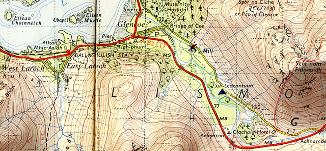
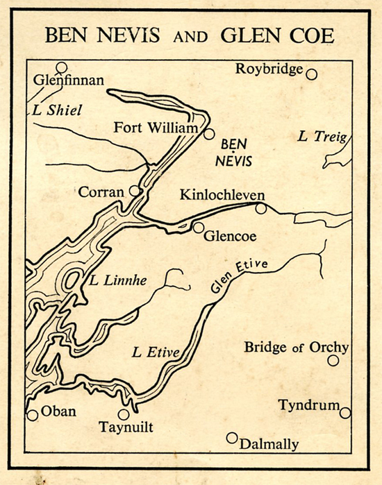
Part 7. Glen Coe, Fort William and Glen Nevis, Kyle of Lochalsh and Kishorn. East to Inverness.
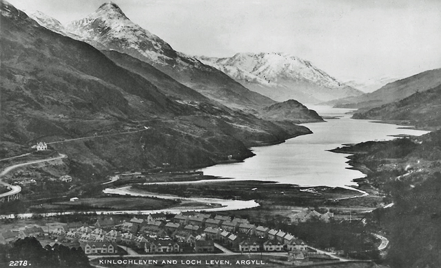
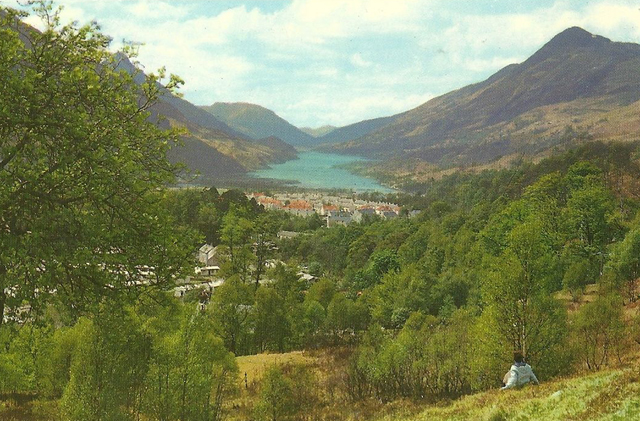
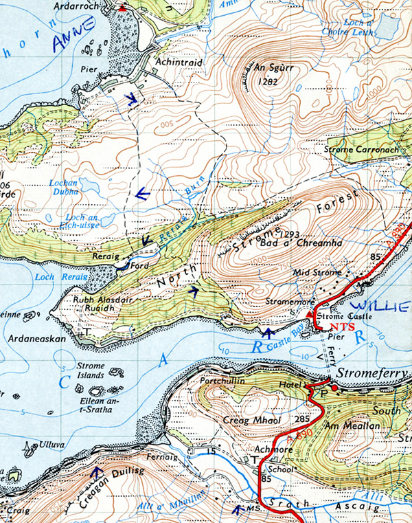
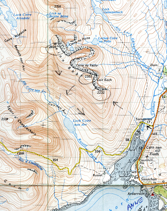
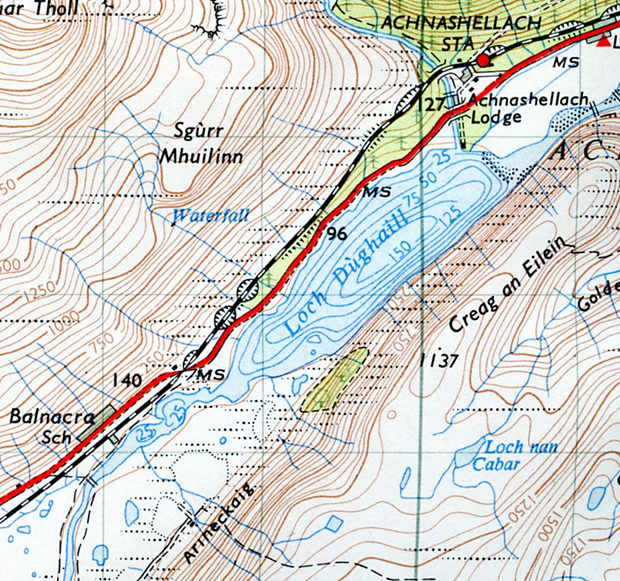
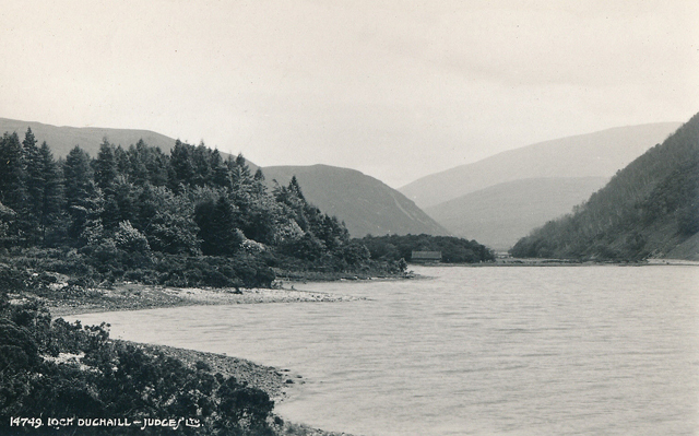
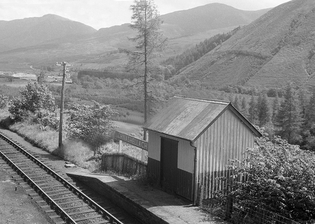
Part 7 is dedicated to the memory of Fred, Kyle of Lochalsh warden, Willie, North Strome warden, Anne, Kishorn warden and Dave, Achnashellach warden, summer 1965. If you’re still around do get in touch, or if you know of them, let me know. Use the Leave A Reply facility at the bottom of this Chapter. Thank you.
___________________________
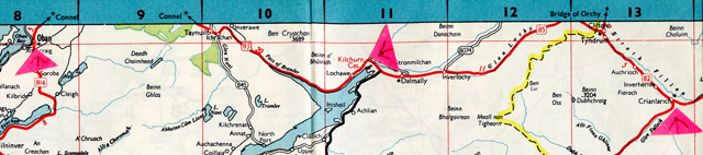
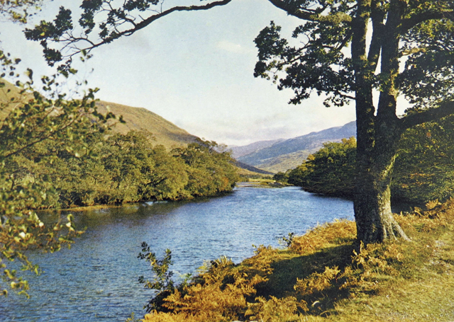
The Story So Far… Liking sooty Glasgow, mysterious MOD development near Garelochhead, Loch Lomond. Frogs at 3100′ in a peat pool by Beinn a’ Chroin and the Crianlarich hostel warden (at the old original hostel) with a sense of humour. Loch Awe and Ben Cruachan before the dam and power station, (but nearly completed). Oban railway station before it was demolished, and on to Glencoe.
To Come Walking Aonach Eagach. The Warden’s husband with a penchant for blokes. A Tiger in his Tank at Fort William and at Glenelg an old woman with rags for shoes and a hat for a pixie. Trouble brewing with the first Sabbath sailing to Kyleakin. Four free-wheeling young wardens in the Kyle of Lochalsh and Kishorn area. Fresh baked bread at Lochcarron. A bumpy ride to Inverness. Aviemore under construction and a Rank “Road Inn” at Loch Morlich.
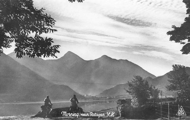
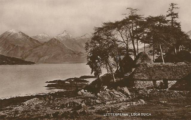
Ratagan youth hostel and Loch Duich
__________________________
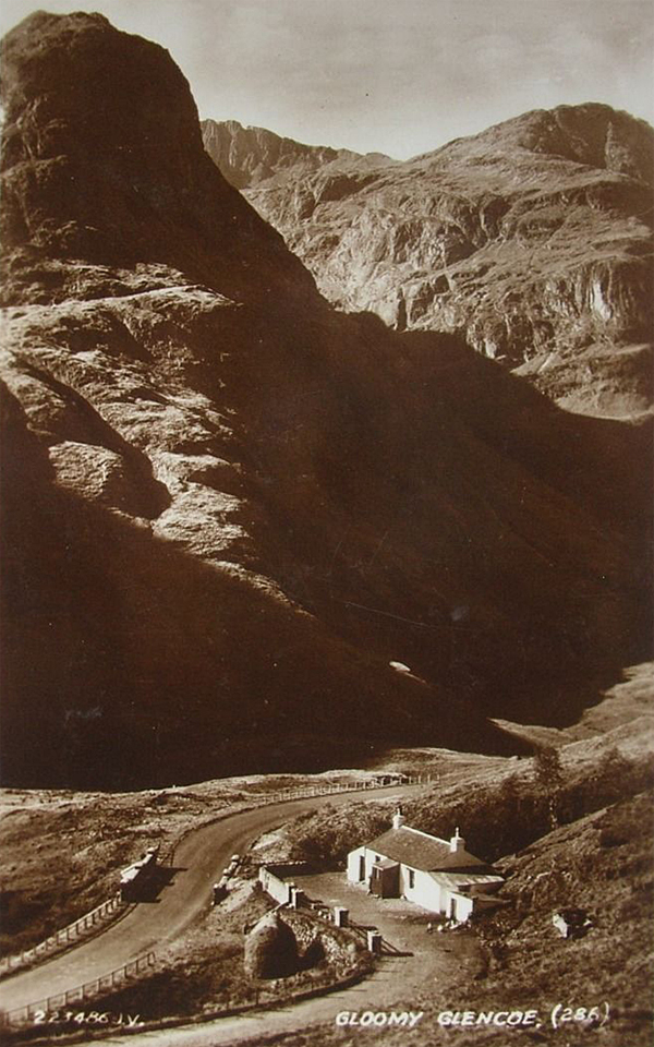
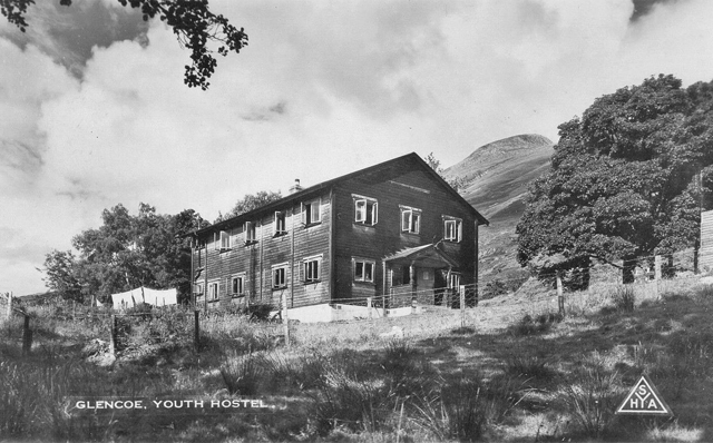
Glen Coe youth hostel, 1960s.
May 19. Wednesday. Around 9.30 a.m. Glencoe hostel.
To finish off what happened last night. I finished the paper work the warden had given me, but realised he wasn’t the warden after all, but the warden’s husband. When I started on the paperwork he disappeared with the young bloke who’s staying here, to the pub, and then turns up later. He says “Would you like to be the Assistant Warden” and drags me into their living quarters. It’s coming up to 11 p.m. His wife, the warden, is there and a sexy bird – her daughter I think – plus a bearded walker and two other oldish blokes, all of whom I think are local. They’re all drinking whisky and watching the Queen in Germany on the TV.
“This is Peter, he’d like to be Assistant Warden.” “Hello Peter” says the warden who I think has a German accent. “Go out to the wee shed and get yourself a bottle of beer”. I do and return, sitting on a cushion on the floor. It’s not too bad, as we sit there watching the TV. I think the warden is interested in watching the TV as it is the first time the Queen has visited Germany.
The Queen HR Elizabeth 11 arrives at Bonn Airport on 17 May, 1965. She is inspecting the Guard of Honour with the West German Federal Republic President Heinrich Lubke. Prince Phillip is just out of picture to the right. This is the first time a British monarch had been on a Royal visit since the Nazi era and the Second World War.
But within ten minutes the warden’s husband creates a scene – he’s pissed, making unpleasant remarks. People pretend to ignore him but there’s an embarrassing atmosphere. I excuse myself and leave. I didn’t need that. It’s 11.30 p.m. The electricity in the hostel itself is off, so find my way up the stairs to the dormitory in the dark.
This morning there’s a blue sky outside as I write this, just a few clouds, the Common Room windows are open and the air’s warm. I’m about to set off for the Aonach Eagach.
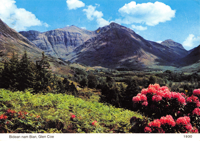
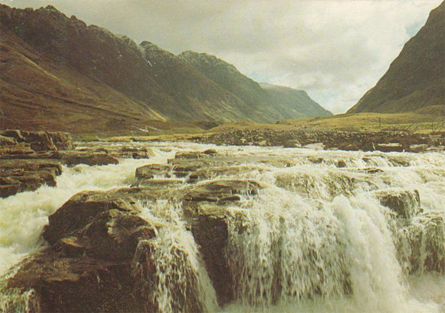
Am Bodach – on the ridge. Left the hostel around 10. Blue sky, some cloud. Warm. Walk along the road until joining the main road at Loch Achtriochtan, small loch at head of Glencoe Pass with the River Coe running into it, and several smaller streams. Walk along and the Three Sisters really impressive, especially Aonach Dubh with layer after layer of crag going up, and trees on these crags and the grain seems to be running down to the valley. Three big buttresses sticking out into Glen Coe.
The Three Sisters, Glen Coe. Aonach Dubh on the right.
Walk along the road – some transport passes – until I come to Hamish MacInnes’s cottage – a delightful low white-washed cottage at the Meeting of the Three Waters.
Bridge of the Three Waters, Glen Coe. 1930s postcard. In the 1960s the cottage was lived in by the climber Hamish MacInnes.Meeting of the Three Waters, Am Bodach and the Aonach Eagach, Glen Coe.
Eat a packet of Glen Garry biscuits and then take the path along, up the stream. There’s a little electrical generator for the cottage, worked off a wheel with paddles that the water turns. Ingenious. So up the steep slope, keeping to the left of Am Bodach. At Am Bodach, 3080′ there’s a view over to the north of Ben Nevis, still quite a lot of snow over there.
From Am Bodach it looks like a challenging walk along the ridge of Aonach Eagach.
The Aonach Eagach ridge, Glen Coe.
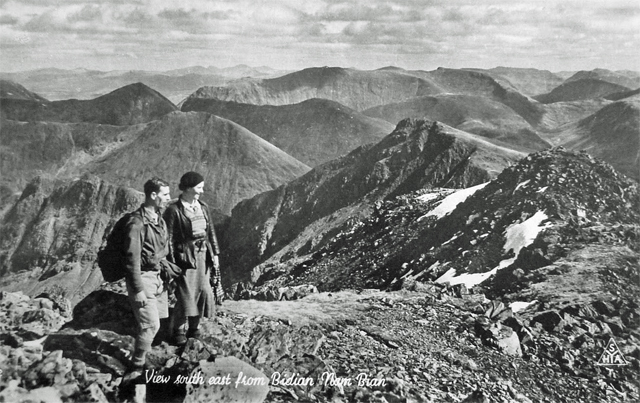
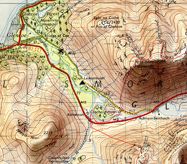
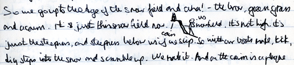
Glen Coe Hostel, evening. Yes, from Am Bodach it was challenging walking along the Aonach Eagach. It was more a mix of climb/scramble/walk. At first it doesn’t seem as challenging as Striding Edge, but by Christ, it turns out doubly dangerous, and this is in good weather. In bad weather it would be suicidal. At places it’s a foot wide with sheer drops either side – and that’s no exaggeration. At times the path comes up against solid rock, so it’s a case of crawling up, gripping on rock, luckily there are plenty of hand and foot holds. Then at times it’s a case of carefully working your way down a gully. The ridge is like spire after spire, so it’s not fast or easy going. And fresh white snow sprinkled all over the place. Soft to tread in. Beautiful compared with the other old stuff.And on either side there’s more spires and pinnacles coming up and big, deep gullies going down. Magnificent, but frightening. On my left the Three Sisters and occasionally the valley and road below when you catch a glimpse of it between the pinnacles. And on the right Ben Nevis all the time and Loch Leven. After 3080′ it’s plain forward green grass and wide ridge walking, and you see Loch Leven widening out into Loch Linnhe, and in the distance the sea.
Come to trig point at Sgor nam Fiannaidh which isn’t marked on the map. Yes, there’s a lot of inaccuracies on this map.
Sgor nam Fiannaidh. Acknowledgement Ordnance Survey One Inch Tourist Map Ben Nevis & Glen Coe, 1959 revision.
Built around the trig point is a round stone shelter and some bloke with a misplaced sense of humour has stuck a small Union Jack on the trig point – but I laughed. I continue and all of a sudden I see Glencoe village and Ballachuillish.
Glencoe village and Ballachulish. Acknowledgement Ordance Survey One Inch Tourist Map Ben Nevis & Glen Coe, 1959 revision.
The street down there in Glencoe looks dead straight, with houses lining it, and the main road, looks all planned. And there’s a Sikh wearing a turban going door to door with a suitcase. Probably a Betterware salesman. And the green valley flat, flat and fertile, and the Loch. I can also see the hostel and the wood by it. All very small, like a model. I start the descent, but make a stupid mistake – the descent is steep with loose scree hidden by heather. Treacherous. Try going down a gully, but that’s too steep too, with rocks shifting under my feet so climb back up, swearing gently. Walk further on and descend on the lower, greener slope – running down it, a kind of exhilaration, and at the bottom come right out by the hostel.
Take my boots off outside and enter. The warden’s husband’s there, and so begins the cat and mouse game – only I don’t know who’s the cat and who’s the mouse. “Would you like some soup?” “O.K.” So I have some very peppery home made soup. He’s lurking around. Wash the bowl in the self-caterers. “Come out for a drink, around 9, Peter?” “No thanks.” “Have you read Lawrence of Arabia?” Makes a variation of the usual “Have you read Giovanni’s Room” approach. (Giovanni’s Room by James Baldwin. In the UK in the 1960s the title of this book was used by many male homosexuals to test out the sexual orientation of other men. The former Liberal Party leader Jeremy Thorpe used this approach. T.E Lawrence wrote Seven Pillars of Wisdom. Lawrence of Arabia, a biographical film of his life with Peter O’ Toole, directed by David Lean was made in 1962.)
No, I haven’t, I respond. He tells me he was captured during the war and it shocked him to realise he was a masochist – (he pronounced it ‘machochist’). And then “Did you go public school, Peter?” Presumably he thinks all public school boys are queers. And then I started remembering things from last night – he’d said his wife wanted a male assistant, yet later in their quarters she had said they had a girl assistant in mind. She will know what a young male assistant would be in for. Hence a girl assistant. He continues for a bit with me and I act cool throughout all this. He’s not getting anywhere and takes the hint. The pestering stops, and he makes some excuse about having to check something, and pushes off.
Make myself a meal. Quite a few in tonight, including a couple of Scottish girls, a couple in their thirties, two English girls and a male Canadian and a bloke called Lou. Around five to eleven the warden’s husband comes into the Common Room where we are and gets stupid – nasty. “Lights out in two minutes, folks.” One of the girls asks him where she can hang her washing and he says “Outside”. “How can I get out there?” “Through the door”, not smiling. He follows us upstairs to the dormitory. I’m brushing my teeth, he hangs around. And before we’ve had a chance to get into our beds, he turns the light out.
____________________
May 2o. Thursday. Late morning. In the valley of Allt Coire Gabhail.
Leave the hostel about 9.30 a.m, along the road that leads to Meeting of Three Waters, until I leave it, taking the track from Achtriochtan which runs at a lower level. The track follows the small gorge where the River Coe gurgles and rushes through. It’s wooded and pleasant. Cross by the bridge at the Meeting of the Three Waters to the other side and climb up, following the burn to Allt Coire Gabhail, otherwise called Hidden Valley and it’s really something. Looking at the map you’d think just another V shaped grass sloped valley. But no. It’s a beautiful wide gorge going up to Bidean nam Bian 3766′.
Allt Coire Gabnail, Bidean nam Bien and Stob Coire. Acknowledgement Ordnance Survey One Inch Tourist Map Ben Nevis and Glen Coe, 1959.
Cliff face on one side of Gearr Aunach and on the other side the wet dark cliff face of Beinn Fhada, water running off it. But there’s more to it then that – the gorge is full of large slabs of rock, boulders AND trees, trees, trees, seemingly growing out of the stone. Beautiful delicate green fresh leaved trees – ash and sycamore – and then the scree and boulders and the sun’s so warm, the sky’s so blue. As I made my way up following the stream I thought “Aha – pitch a tent here for sometime”. And I may do if I get the job at Glasgow, and get a break for a week. I’m writing this at the point where the stream emerges, comes pouring out like water from a tap, from the dry stone, boulder filled stream bed.
Bidean nam Bien, photographed in late June.
Hostel, night time. The boulder filled stream bed was quite a scramble, and suddenly and dramatically it opens out into a flat valley, no trees, no boulders with Bidean nam Bian up there, and the flat valley looks like a big arena with three mountain sides, and the wooded valley I’ve just come up below.
Start climbing up the pass between Bidean nam Bien and Stob Coire. It’s a steep climb through snow fields. I’m surprised there is so much snow, it really is extensive, one hundred, two hundred yards up to the pass, where it hangs over, as if it were going to break off. Slowly make my way up, digging my toes in – occasionally my foot goes right through, but it’s mostly alright. Make the pass.
View from Bidean nam Bien. Circa 1930s/1940s postcard.
The other side is extensive scree, nothing but scree. Descend, at times sliding with the scree that in places is the size of chippings.
Get down into the valley and a fairly easy descent along a sheep track to near the farm. I think I can cross the River Coe, rather than go the long way round by the road to the hostel, but after trying to cross twice unsuccessfully I’m forced to go by the road.
River Coe.
Make myself a meal at the hostel. A Scottish couple arrive, we talk. Some other new people too, but not crowded. One of the new blokes, and Lou who came last night have gone down the pub with the warden’s husband. Lou seems to be his attraction for the moment.
________________________________
May 21. Friday. Glen Nevis Hostel. 9 p.m.
Glencoe to Kinlochleven and the Old Military Road to Fort William and on to Glen Nevis youth hostel. Acknowledgement Esso Map No 7 Northern Scotland, 1962.
Walked along to Glencoe village from the hostel this morning and stand on the Kinglochleven road and hitch, but no go, so walk to Kinlochleven. The road follows the loch, above it, looking down.
Kinlochleven foreground and Loch Leven. The road from Glencoe to Kinlochleven is on the left.
And down there at the head of the loch is Kinlochleven surrounded by mountains. Orange roofs amongst green trees.
Kinlochleven at the head of Loch Leven. “Orange roofs amongst green leaves.”
Kinlochleven is a pretty horrible 1930-ish development. Unpleasant council looking houses, grey with green or orange/red roofs. Probably developed with HEP (Hydro electric power) pipe line that comes down the mountain side. (Kinlochleven was built earlier than the 1930s. It was built when a hydro electric power scheme was built by the British Aluminium Company to power an aluminum smelter in 1907. At its height British Aluminum Company employed 700 people at the smelter. Kinlochleven was the first village in the world, in 1907, to have every house connected to an electricity supply. The smelter closed in 1996, with subsequent loss of jobs. In his ignorance Le Patron did not realise that the grey external cement rendering over brickwork on most twentieth century Scottish social and company housing was a necessity imposed by the adverse weather of Scotland – rain and frost in particular).
There’s the inevitable Co-op, but it’s closed, but there’s a grocers that’s open and I buy some food and matches and find out that it’s 1.45 p.m. I ask about a bus in the grocers and am told there is one to Fort William at 20 past 6. Outside I eat a packet of Fruit Shortcake biscuits and decide to walk it, along the old Military Road. A steep sweaty walk up the hillside out of Kinlochleven to the “road”.
The old Military Road from Kinlochleven to Fort William. Acknowledgement Ordnance Survey One Inch Tourist Map Ben Nevis & Glen Coe, 1959 revision.
The Military road is murderous to walk along, pebbles, boulders, crushed rock. Difficult under foot. It follows the valley Allt na Lairige Moire. Pass a couple of derelict farms. Turn the corner and follow it down to Blau a’ Chaoruinn, a derelict cottage.
Blar a’ Chaoruninn, Blarmachfoldach and Glen Nevis youth hostel. Acknowledgement Ordnance Survey One Inch Tourist Map Ben Nevis & Glen Coe, 1959 revision.
Grey/black clouds suddenly forming. Along to Blarmachfoldach, now a properly made up road under foot. Turn to the right, up a track to a small loch and by now it’s raining heavily, and descend down the hillside, through a very dense coniferous forest, until emerging out into a field and the hostel. Hostel is fairly full with school parties and walkers. There’s a youngish Australian bloke here and a Scottish couple, John and Betty, and the four of us natter away in the self-cookers.. I’ve just paused to write this up, whilst John has put the kettle on to make us all a cup of tea.
____________________________
May 22. Saturday. Glen Nevis hostel, evening.
Fort William and Ben Nevis. Acknowledgement Ordnance Survey One Inch Tourist Map Ben Nevis & Glen Coe, 1959 revision.Glen Nevis youth hostel.
The day starts with a downcast, downcloud morning, and John and Betty – who’s attractive – and Barry the Australian and me walk down to Fort William. Barry’s OK, great to listen to. So we walk down to Fort William, the hills covered in white misty cloud.
Fort William and Ben Nevis on a sunny day.Glen Nevis youth hostel (bottom right) to Fort William. Acknowledgement Ordnance Survey One Inch Tourist Map Ben Nevis & Glen Coe, 1959 revision.Fort William, circa 1965.
We wander aimlessly around Fort William, looking in at shops, a Scottish crafts exhibition, 1/- admission (5p.). Into a coffee bar. Whilst we’re in there I nip out to buy a packet of biscuits. First shop I go in there’s this girl assistant packing groceries into a cardboard box, taking no notice of me as I stand at the counter, and then goes into the back and that’s the last I see of her. I say “Excuse me”, but no one comes out to serve me. “Anyone there?” Still no-one comes out, no-one’s bothered, so saying “Sod it” I leave and buy 3 packets of biscuits in another shop.
Go back to the coffee bar, but it’s a curious place – not really a coffee bar – two old women in a small space pouring out miserable cups of 6d. tea. We’re sitting by the window, looking out onto the street. We haven’t got much to say, place is depressing. Finish the tea, leave and into a pub for a pint. First pint I’ve had in Scotland and it tastes sweet. (Scottish beer – “heavy” – is not hoppy like English bitter.) Barry talks and he’s entertaining to listen to, beautiful soft Australian accent and makes Australia sound interesting.
Mostly locals in the pub. Old blokes drunk, arguing amongst each other about nothing. Some very drunk. One bloke concentrating on slowly picking his pint up, and trying to match the glass to his mouth without pouring it down his neck.
We emerge and go into the museum – another 1/-, not that good, and after shuffling round it, emerge, slowly starting to make our way back. Pause to watch a shinty match. Hockey for men, sticks swinging high, looks dangerous.
So wander back to the hostel. Alan joins us, who was there last night, a Scottish bloke who’s a laugh with his yellow cape and “I’ve Got a Tiger in My Tank” sticker on the back, as we walk down the glen back to the hostel. (“I’ve Got a Tiger in My Tank” were stickers that many motorists stuck on the rear window of their car. They were part of a promotion campaign by Esso.)
Esso: Put a Tiger in Your Tank. 1960s promotion campaign.
I cook my tea, but made too much spaghetti and put too much water in the tomato sauce. However. Never mind. We’re sitting around afterwards at a table in the self cookers and a Chinese/American turns up from California, who Barry says he met in Glasgow a couple of days back.
Later in the evening we decide to go back to Fort William for a drink, and I went with them as I was bored. Try to find a quiet pub, going from pub to pub, and Alan’s caught up with us, still wearing his cape, with two bloody awful girls he met in the hostel. And as Barry says “What are we doing?” Yea, what are we doing, so I turn around and start to walk back to the hostel with a mate of Alan’s. We buy some chips from a mobile fish and chip van. Plenty of local drunks around. Half way down the glen road we get a lift and the driver drops us off at the hostel.
And a phoney bloke – a con man – who we’d seen in Fort William earlier in the day seems to be staying the night. Well, he’s hanging around the hostel. He dresses up as a sort of Bonny Prince Charlie, kilt, berry, feather, the whole works like something out a Walt Disney film. He was charging tourists money to let them take photos of himself. And he’s English.
______________________________
May 23. Sunday. Glen Nevis YH. Evening.
Today it was overcast and occasionally it rained. After breakfast eleven of us set off to the waterfall at Steall. Myself, Barry, John, Betty, Tom – the Chinese Yank – Alan, Ian his mate and four girls who remained nameless but two of them were worth looking at. Along the road to Achriabhach.
Achriabhach, Water of Nevis, Steall waterfall and Steall cottage. Acknowledgement Ordnance Survey One Inch Tourist Map Ben Nevis & Glen Coe, 1959 revision.
Where the road finishes there’s a coach parked and lots of tourist cars. Cross the bridge, now on the track.
Water of Nevis, Glen Nevis. 1930s postcard.
Onwards. Mountains towering either side and a mountain in front so that it looks like a cul-de-sac. The track ends and it’s now a footpath that runs into the gorge, the River Ness frothing through it. Me and Barry ahead, Barry taking the rucksack. Along the path and the gorge opens out into a valley and there’s the waterfall, falling down the mountain side.
Steall Waterfall, Upper Glen Nevis. Photo and Acknowledgement Geological Survey and Museum, London.
And Steall Cottage. A tent is pitched by the wire bridge that spans the river. Go over the bridge – swinging around – V – that’s how it looked – one wire to walk on, two to hold. Barry and me work our way across OK. The cottage is locked and belongs to some climbing group. Eventually the others catch up, crossing the wire bridge OK too, and we sit in the woodshed attached to the cottage. Alan’s primus stove going and my coffee, as no-one – who? – remembered to bring any tea. We had five cups – enamel cups – that we took it in turns to drink out of. Eventually we all leave and Alan and I return by the other path, on the other side of the river only when you come to the gorge you’re amongst the boulders and rushing water, so we climb up and over the hill, rejoin the path, continue, cross the river, join the other path and catch up with the others. Barry’s talking to the Swiss girl and her father, who turned up at the hostel last night. As we walk along the road a RAF Mountain Rescue Landrover picks us up and drops us off at the hostel. I spend most of the night talking to two warped Catholic girls.
I don’t feel like writing anymore at the moment. Could write a lot more but won’t.
____________________
May 24. Monday. On the path to Ben Nevis.
Glen Nevis youth hostel to Ben Nevis cliffs. Acknowledgement Ordnance Survey One Inch Tourist Map Ben Nevis and Glen Coe, 1959 revision.
Up 8, left 11. In between had breakfast, collected food people didn’t want, said goodbye to Barry as he left with his heavy rucksack. Yea, nice bloke. The Chinese Yank left too, after doing his job. When asking the warden what his hostel job was he said “Sir”, which I’ve notice all Americans say. Hung around until John and Betty left, said goodbye. And then set off, crossing the bridge over the Ness Water, up the slope and along the path for Ben Nevis summit. And at the moment, sitting here, writing this I feel I’m just standing still. I can’t define how I feel. I’m just not using up my energy. Felt it very strongly at breakfast. I’m drifting and I’m fed up. I want to write. One thing I want to work into a play is the way when you’re listening to someone you look at his girlfriend and she looks at you and he doesn’t notice. It’s a nice touch.
There’s four girls coming up the slope towards me, as I’m writing, and there’s one in tight black tights and tight red jumper that I’d like to screw. However, that’s not going to happen, is it. Cloud again, like yesterday – mist and low cloud on Ben Nevis, so there’s no point in going to the summit. Totally pointless – I won’t see anything and I’ll get wet. Snow capped peaks behind me. Overlooking Lochan Meall an t-Suidhe – a loch perched, or rather, in the saddle between Meall an Suidhe and Carn Dearg. Sweaty walk up to here, boulder pebble path, pass an oldish couple, me still feeling useless, bit of blue sky now, but it won’t last.
Ben Nevis “cliffs” on the north east side of Ben Nevis.
Hostel, evening. So, I continue round to the cliffs, although you can’t see them to their full height as low cloud was swirling around, rather interesting and terrifying. Jagged, rising up, like fairy tale mountains in a cartoon Walt Disney – mountains where wicked witches live in castles. The mist’s swirling around and small streams are running down the face and disintegrating into spray with the fierce wind. There’s a mountain hut for climbers. Go past it, smoke a cig, return. It’s now pissing down and I’m getting wet. Walk back and down to the hostel.
The Bonnie Prince Charlie con man is hanging around again this evening. He’s talking phoney nonsense to anyone who will listen, but most can see through him.
________________
May 25. Tuesday. Near Ratagan YH. 3.15 p.m.
Yes, near Skye – great luck. But first the story. It’s sunny and close when I leave the hostel this morning and walk along the road towards Fort William. Last half mile into Fort William I’m accompanied by one of those insufferable “guess where I’m from” blokes. A very boring bloke from Rotterdam who’s telling me how he spent 25 days in Edinburgh waiting for his passport.
Fort William – that none too pleasant town and turn right and walk along the Inverness road until I get past the turn off for Corpach. I stand just past a filling station and the “Ben Nevis” distillery opposite, and the British Aluminum factory up the road. The leaves on the trees are very green, and there’s something about where I’m standing that reminds me of the Continent – reminiscent of times spent by roadsides waiting for lifts. And I wait a long time. Most traffic turns off for Corpach – big pulp mill there – and I reckon any lift I get will be going towards Inverness. Hitch, smoke, watch a lorry get loaded with barrels of whisky and then driven to the store sheds just down the road and back again, and gravel lorries and contractor’s lorries – “Logan” – going backwards and forwards. They’re widening the bridge into Corpach. So I’m standing there thinking “Where the hell am I going to be tonight – Will I have to get a bus or train?” But they’re so infrequent – MacBrayne’s Royal Mail Highland buses – but Mini stops. Young bloke with little wispy Edwardian moustache, tweed jacket, old school tie, trousers, socks up to knees and shoes. From Berwick upon Tweed. Smoking Silk Cut and, AND he’s going to Kyle. Real luck – and off we go.
Fort William – Invergarry – Shiel Bridge – Ratagan. Acknowledgement Esso Map No.7 Northern Scotland, 1962.
Along Loch Lochy to Invergarry Hotel and turn off left for Skye, driving along Loch Garry, Loch Loyne and Loch Cluanie. Good scenery – getting wild, barren, rocky around Loch Cluanie, the road becoming single track with passing places. Stop at an Inn which has a complete monopoly on this stretch of road – hence 7/- (35p.) for 8 small cheese and ham sandwiches, and I mean small, really tiddly. 7/-. Fucking robbery, only I wasn’t paying. I bought two Mackeson’s – 4/- no draught. Another oldish couple in the place. Edward Gardner, Conservative, Round Table sort, and his wife. (Edward Gardner, Conservative MP for Billericay, Essex 1959 – 1966.)
Kintail Mountains from Shiel Bridge. Early Spring view.
They leave and we leave. Driving along a rough, unmade road – it’s rough as it is being widened, with Ed. Gardner and wife in front in a Rover. I get dropped at Spiel Bridge and again, luck of luck, there’s a petrol station, cafe and store and manage to get OS 26. (OS Map 26: Locharron.) So I’m all set.
One Inch Seventh Series Ordnance Survey Sheet 26 Lochcarron. Published 1957. Minor Revisions 1961.Area covered by Ordnance Survey One Inch Map 26 Lochcarron.
Ratagan YH around 8.30 pm. The hostel’s bang on the shore of Loch Duich.
Ratagan youth hostel, Inverness-shire.Ratagan youth hostel and Loch Duich.
I’m sitting in the common room cum kitchen, small friendly, little window directly in front of me with the loch and the opposite hills. Beautiful, but the place is spoilt by some insufferable inmates. A sun-tanned Englishman with a moustache – looks like a 1928 colonial tea planter – who drove me up the wall making a foul noise eating his meal, slurp, slurp, and two cyclists, a male and female (in electric green glasses) plus the warden, all talking shit, passing bitchy comments. Feel like mowing the lot down. But if I had the place to myself, if it was quiet in here, it’d be as good as Nant-y-Dernol. The men’s dorm is a warm attic in good repair. It’d be a beautiful place to live in.
The view from Ratagan.
As I walked by the side of the loch to the hostel from Spiel Bridge there was a strong smell of salt in the air – it’s a sea loch, seaweed on the shore. Instead of being in the hostel with this lot it would be nice to sitting in a tent by the lochside, and have a scooter. Be really independent. If I get the job at Glasgow I’ll probably buy a scooter.
_________________________________
May 26. Wednesday. Glenelg YH. Evening.
Before I set off for Glenelg this morning I left my rucksack at Ratagan and walked back to Shiel Bridge to get some more provisions. The 1928 English tea planter accompanied me as he was returning eggs he had bought there, which he said they were “Off”.
Low cloud on the hills but lovely day and the Loch very, very still, and again the strong smell of salt in the air. Plus the coconut smell of the yellow gorse in bloom. The coconut cake pointy hills opposite. One has a forest on its lower slopes and the rest is bare – looks as if it’s had a shave. Provisions bought I return to YH, pack them into my rucksack, have a pee in the Gents at the back of the building and set off along the little road that follows the loch.
Letterfearn, Tataig, Eilean Donnan and Ardintoul. Acknowledgement Ordnance Survey One Inch Seventh Series Map 26 Lochcarron, 1961 revision.
Nice little road, grass growing in the middle of it. And yellow gorse bushes growing everywhere, and long grass and bluebells and nettles and primroses. Lettterfearn is the hamlet along this road. A collection of small cottages and a school with about five kids playing football with a red plastic ball. (The school is now closed.)
“Children at Letterfearn”. 1898. Reproduction postcard. Original source/photographer unidentified.
A lot of the cottages have tin sheet roofing. There’s rowing boats on the shore. It’s nice.
Letterfearn, circa 1910. A Valentine’s of Dundee postcard.Letterfearn, Loch Duich. Autumn photo, 1960s.
Walk on to where the ferry once operated from a cottage with a slipway called Totaig across to Eilean Donnan. Eat a packet of Rich Abernethy biscuits, drag on a cig. Walk on. The road, as such, ends here and from now onwards it’s a footpath. It goes into a Forestry Commission area, only it’s not regulated coniferous trees, but a glade and there’s a cove down there with three white boats, no one around. Peaceful. Continue on the foot path to Ardintoul.
Ardintoul and Ardintoul Bay. Acknowledgement Ordnance Survey One Inch Map 26 Lochcarron, revision 1961.
Ardintoul is an interesting place. You look down on it from the footpath, a small peninsula, if you can call it that, nestling amongst the hills. It’s flat with very green fields, about five at the most. Drives of trees and a few cottages and one big Georgian farm house. What’s interesting is that it is completely cut off. No road or track to it. Just this footpath. There’s a tractor down there, so they must use a boat to bring stuff in. Cross Allt na Dalach and sit on the remains of a cottage. Go down passing an empty cottage, with a red oxide paint tin roof, along a drive of trees and then along a stone wall by the shore. Past a second empty cottage and past the big inhabited farmhouse, bottles of butane gas out on the verandah and a friendly black sheep dog accompanying me. (The “farmhouse” was built in the 1700s by the MacRae family about the time of the destruction of their hereditary stronghold Eilean Donnan Castle across the water. The farmhouse building was destroyed by fire August, 2012. It was uninhabited at the time.)
And between the farmhouse and the shore there’s two big gas looking cylinders – like you see at a gas works, one built of bricks and there’s military fencing around them. Interesting. (They were oil storage containers built by the Royal Navy during the Second World War. They were decommissioned a while ago. There is little now to indicate that they were once there.)
Continue to another cottage and a byre for tractors. Plenty of sheep and lambs around. Skye is directly ahead of me, go round Garbhan Cosach, the headland, and walk along the shore of the channel between the mainland and Skye.
Ardintoul to Glenelg youth hostel, Glenelg to Kylerhea ferry, coast walk to Kyleakin and ferry crossing to Kyle of Lochalsh. Acknowledgement Ordnance Survey One Inch Map 26 Lochcarron, 1961 revision.
Climb up the hill. See the ferry and the slipway. Not many cars. (The Ordnance Survey One Inch Map 26 Locharron, “Reprinted with minor changes 1961” shows the Kylerhea – Glenelg ferry as foot passengers only. It also shows a track from the Kylerhea slipway, rather than a made-up road. In 1965 the Kylerhea track was tar-macamed and the ferry vessel could take approx. four vehicles.)
Walk to the hostel. Dr. Johnson is reputed to have stayed in it when it was a cottage. It’s locked, so wait around as I’m not sure about the time. Watch a Ford Anglia turn up at the ferry, then change its mind and go back, and then a GB Mercedes turns up. Hear the door of the hostel/cottage being unlocked and enter. Old couple, bloke looks like a fisherman. Friendly. Have the place to myself. Have a reasonable meal and I’m writing this sitting at a long table by the window of the Common Room, which has one of those old iron ranges that nearly all these small SYHA’s seem to have. From the window I have a view of the straights, Skye and over there the hamlet of Kylerhea. All the cottages are white-washed and spaced out and the fields are open and unfenced. Looks foreign. Unusual. Pleasant.
____________________________
May 27. Thursday. On a bench outside Kyle (Lochalsh).
Made myself breakfast of porridge, Quick Quaker Oats, instead of the usual Crofter or Scots oats, cup of coffee with diluted evaporated milk and away after warden’s wife gave me my card. She’s a funny little woman, wearing a peculiar sort of pixie hat and on her feet what looked like two rags tied at the ankles.
(In the above photo of Isabella MacDonald at Glenelg her children are barefoot. The baby on her back is approximately one year old. In 1965 that baby would be 76 years old. Would she be wearing rags on her feet?)
Wait by the slip, smoke a cig – the ferry’s at Kylerheah. Ferry comes across, car goes on, then me. Ingenious thing. It’s a revolving turntable on the boat. Boat comes up by the side of the slipway and then swings the turntable onto the slipway, the ramp is let down and away you go. So across I go, for 6d. (2½p.)
Glenelg-Kylerhea ferry. 1960s.
Land on the other side, on Skye, and turn right and scramble along the hill-slope until finding the path. So along it, passing the small lighthouse and after that the path flakes out, despite it being marked on the map. So it’s up to your initiative. Until you round the headland it’s not too bad. But after that it’s bloody murder underfoot. You wouldn’t know from looking at the map – there’s trees, fern, bracken, heather, rocks, boggy spots, everything to make it uncomfortable underfoot, stumbling from one spot to the other. There’s a wreck down there, sticking out of the water and on the shore some blokes dismantling a large piece of it. Rusted brown metal. Looks like a frigate.
Stumble, stumble on, at times descending and walking along the shore, and then having to ascend where it gets impossibly rocky and sea’s lapping up against the rocks. And so it continues until I descend to the cove Loch na Beiste and I’m glad to reach the head of it, and then have to climb out of it and – ah moorland! I stride across it, soggy, squelchy, until after this murderous walk the beautiful sight of Kyleakin down there – shops, and the ferry.
Car ferry, Kyleakin. Late 1950s/Early 1960s.
Descend down into it, ducking underneath a washing line with washing on it. Cottages that back into the hill slope. I’m hungry. Go into a shop that has “General Stores” written on the outside but just sells paint. Go into another shop near the slipway and buy food, including a packet of rich tea biscuits and a date bar. Eat the biscuits by a wall, seagulls flying around. Packet half eaten get on the ferry and over to Kyle. Landed and ho-ho, what do I find – most of the shops are open. SYHA handbook says Thursdays are their half-closing day. Stuff is cheaper, like eggs. Oh well.
The Kyleakin (Skye) ferry arriving at Kyle of Lochalsh. A Post Office van waits for the mail bags. 1960s.
Buy some more food and find out it’s 3 and trot out of the town and sit on a bench near the old, tin roofed Victorian school which is the hostel – which looks ghastly from the outside. Iron railings and dead looking.
“Kyle of Lochalsh – Gateway to Skye”. 1960s postcard.
Kyle YH. Evening. The hostel is better on the inside. Whilst I was waiting asked a passing woman with a young child the time. She said she thought it was four. Go up and try the door, and it’s open. Met by a zooty young cockney warden with ginger hair, beautiful white teeth, and friendly. Keen cyclist/hosteller and a good bloke. He’s called Fred. Older woman cyclist turns up, who when she started talking went on and on and on but she was OK. Later, around 8 p.m. a Belfast college bloke comes in. A good evening. Fred the warden, the woman cyclist and me talking, having a laugh. Fred’s been wardening 3 years in Scotland – during the summer. North Strome last summer. A real cockney from Hackney and active with the Central London YH group.
______________________
May 28. Friday. Kishorn YH.
Wake up at Kyle YH and it’s a good day outside and the Cuillins looking clear, seem to rise up out of the sea. It’s a promising day. As I was packing my rucksck to leave a couple from the SYHA turned up. They seem to go round checking things are OK with the wardens at the smaller hostels around here. Fred was talking to them as I leave at 10.30 – gives me a wink – and start what turned out to be one of the best walks I’ve done for a long time.
Kyle of Lochalsh – Plockton – Strome Ferry – Kishorn youth hostel. Acknowledgement Ordnance Survey One Inch Seventh Series Map 26 Lochcarron, 1961 revision.
Trot along the main road, the sea out there, the air warm and I’m already feeling good. Hardly any traffic. A view of Skye and small islands. The single track railway, the yellow gorse bushes, the telegraph poles and hummocks and hillocks. Turn off onto the minor road to Drumbuie and Duirinish. Beautiful road. Drumbuie is a collection of crofts, off the road to the left. Most have tin sheet roofing, presumably replacing heather thatch, or nailed on top of old thatch. The cottages are in a general area, no road between them, just together with chickens running around, scratching in the dust. Cows grazing, sheep, and its flat down to the sea – open fields, no fencing. Strip cultivation – one strip ploughed, another for grazing, another fallow.
Kyle of Lochalsh – Drumbuie – Duiriness – Plockton. Acknowledgement Ordnance Survey One Inch Seventh Series Map 26 Lochcarron, 1961 revision.
Continue along road and come into Duirinish and coming into it there’s several leafy big beech trees and a farm, farm implements. Cottages on either side of the stream which runs through the village and cottages lazily arranged, strung along the road. A couple of young children playing, an old man, the sun’s out, quiet and warm. Over the bridge and take the minor road through a wood that eventually runs by Loch Lundie. There’s a beautiful smell of greenery in the wood and the loch’s beautiful and distinctive. Further on, on my left is a view looking over to Plockton, cottages along the coastline, whitewashed cottages, sea looking beautiful, and the shore of Loch Carron over in the distance.
Plockton, Ross and Cromarty.
Walk on to Craig, a couple of cottages and then along what must be the most beautiful stretch of coast in the British Isles – the sea below you, the single track railway line and cliffs above you. The warm air is heavy with the scent of the yellow gorse and there are crimson/red flowering wild rhododendron and trees and long lush grass, the islands in the distance and the sun on an intensely blue sea.
Craig – Achmore – Stromeferry – Kishorn. Acknowledgement Ordanace Survey One Inch Seventh Series Map 26 Lochcarron, 1961 revision.
Further on pass a derelict cottage just off the track. Go and look at it. By a stream, beautifully situated with this wonderful view. Gorse bushes and sheep grazing by it. Inside it’s in good condition, although the farmers let his sheep in. There’s the old range, and I hang around, dreaming. I’d like to live here, work the land. But oh well, and on I go, joining the A890 – small road, little traffic, through Achmore – a recent Forestry Commission village. Not too pleasant as the houses are, or look like, post war council type houses except built with wood.
Out of Achmore and up the hill, over the hump and down to Strome Ferry. Post Office on the station and by the ferry a small kiosk selling sweets. Buy some chocolate and go across on the ferry for nothing.
Strome Ferry. 1960s.
It’s warm, the water is deep and inviting. Land on the other side, and off again, noticing the SYHA couple are now at the Strome hostel talking to I presume the warden, who looks young.
Follow the coast and take the footpath through a wood, up the slope, and then a steepish descent to Reraig. There’s a new house being built by the edge of the cove. Cross the stream and up and over the next slope, and from the brow there’s a fantastically beautiful view of mountains rising vertically out of nothing on the other side of the loch.
Applecross Mountains from Kishorn. 1970s.
Descend into Ardarroch, white-wash houses on the shore, pass a couple of old blokes, afternoon, afternoon, lovely weather, aye. Round the bay to Kishorn hostel – it’s an old school. Dump my rucksack and try and find the shop. Ask two small boys, they direct me, find it and it’s a great shop – buy bread, milk, spuds, everything I need and return to the hostel. Enter and in the small kitchen there’s litter strewn over the floor. Apparently some dog got in and had a field day with the litter bin. Clear it up.
Loch Kishorn, Ross & Cromarty. 1965.
The warden rolls up on her Lambretta. Young girl, can’t be much more than twenty, pretty, with a nice disregard for her appearance. A shy, retiring Tom Boy and she’s nice – wearing a worn, torn pair of climbing breeches and a pair of broken plimsoles. Her name’s Anne. The SYHA couple roll up, the bloke mends the door the dog got in by, ask if everything’s going alright and they push off. Me and Anne spend most of the evening talking. She does temporary work in the winter – typewriting. She told me that when she started as the warden at Kishorn, on her first week-end on the Sunday she started her Lambretta up and rode out of the village. On the Monday she got told off by a couple of villagers for starting her Lambretta up on the “Sabbath”. So she now wheels it out of sight and out of sound on a Sunday, and then starts it up. Also told me that there is expected to be a demonstration this coming Sunday at Kyleakin as the ferry is going to run from Kyle, the first time it has ever done this on the Sabbath. And so to bed at 11.30. Just me in the place tonight. Good, good day. Good hostel, beautiful place
__________________________
May 29. Saturday. Sitting on a bench by the hostel, 4.30 p.m.
It’s been a glorious day – the weather, the superb scenery – Sguur a Chaorachain, Meall Gorm and Beinn Bhan rising up as I write this.
Beinn Bhan 2936′, from Loch Kishorn. Photographed when there was a dusting of snow. Autumn or Spring.
The weather was beautiful when I set off this morning – still is. Along the B857 road – but just a country road, has the feel of an unclassified road. Through an avenue of trees and out by the small estuary. Tide out, walk along, turn off to the left at the head of the estuary and then up the hill-slope.
Kishorn youth hostel to Beinn Bhan 2936′ and back. Acknowledgement Ordnance Survey One Inch Seventh Series Map 26 Lochcarron, 1961 revision.
Pause to finish off my notes for Friday, long pause. No need to rush. Taking it all in. A tractor ploughing at the head of the loch, the sea, the sun and a car parked down there. So a gradually climb up the slope of Beinn Bhan until reaching the 2232′ point. Sgurr a Chaorachain over there, looking impressive. Flattish on the shoulder of Beinn Bhan as I walk along to the 2505′ point, having taken off my sweater, stripped to the waist, as it’s getting hot. Say hello to some blokes sunbathing at the 2505′ point. Ask them the time – it’s 1.30. Continue making for the trig point, 2936′. The cliff face to my right that juts out is quite something. Wouldn’t like to be up here in mist and take a wrong turn. Opposite Sgurr a Chaorrachain, a great buttress sticking out, casting a shadow over the hillside opposite.
From the trig point I start to descend, a long steep descent, a herd of deer below me. When I get to the 500′ contour line, or thereabouts, it’s easier and I follow it, walking along, above Loch Coir nan Arr and eventually down to the unclassified road. Cross the estuary – the tide’s out, walking across firm sand. Sea weed and pools, and back onto the B road. Walk along to the P.O. looking forward to a meal of bread, tomatoes and cheese – but no bread, so bang goes that. Walk down to the hostel and on the way meet the woman cyclist who was at Kyle – she’s going to Achnashellach. We spend five minutes talking.
Dump my rucksack outside the hostel and sit on the rocks. Anne turns up and joins me. We sit in the sun talking, and go inside when it starts to get chilly. Have a meal of Chow Mein followed by tinned apricots and rice. Afterwards me and Anne spend the evening talking and around 10.30 p.m. young bloke comes in and I recognise him from North Strome – it’s the warden there, Willie is his name. He’s half cut and a laugh. Been drinking in Kyle and decided to come over and see Anne as he reckons she’s lonely, he says. She just smiles. I think he’s got other designs, but he’s so half cut it would take him half an hour to get his flies undone, by which time, even if she had been interested, she’d have lost interest. He takes ten minutes to roll a cig. The surprising thing is that he’s 28, doesn’t look it, looks more Anne’s and my age. He finally finishes rolling his cig. “There”, he says “Cary Grant couldn’t have done better.” I give him a light as he can’t find his matches. We go on talking – it’s mostly him who goes on talking, telling us about a bloke who climbed one of the Swiss Alps wearing plimsoles.
It’s quarter past midnight and we go to bed – Willie and me to the mens dorm. He’s forgotten why he came in the first place. He still talks in the darkness of the dorm as we lie in our bunks. Turns out he’s a Communist, so we have a general argument as he doesn’t think much of anarchism and I’m not a fan of the CP (Communist Party), and then we get onto literature and Gorki and Chekhov. He works at labouring over the winter and blows the lot. He’s broke at the moment. I roll him, and me a cig. It’s two in the morning – I know the time as he’s got a watch, and as I’m smoking it I’m starting to feel peculiar. Soon afterwards I’m sick three times and crap twice. I’m ill – probably sunstroke. Willie is deep asleep.
___________________
May 30th. Sunday. Next morning.
I’m still groggy when I wake up. Willie’s bunk is empty. Put some clothes on. Anne is cooking Willie a meal of bacon, fresh tomatoes, bread and butter. She says there’s enough for me too, but all I can mange is a cup of tea. Willie asks what’s wrong with me. I shake my head and go back to the dorm. And slept till 4.30 p.m. when I hear someone moving around outside. Get up, get dressed, go out. It’s Anne. I make a pot of tea, feel a bit better, drink three cups, she has a cup too. Eat some Rich Tea biscuits and one of Anne’s cakes and write this. A middle-aged couple in a V.W have rolled up. I’ve got a headache and feel like going back to bed. Feel bad again.
_______________________
May 31. Monday. Shore of Loch Carron.
Up around 8.30 a.m. and feeling quite reasonable after going to bed at 10 p.m. last night – after sitting in front of the stove in the kitchen with Anne reading Readers Digest, my jeans, her anorak and breeches hanging on the string across the stove.
The couple in the car went first, then me, depositing my milk bottles at the P.O. and walking along the B road to Lochcarron. Pleasant low, craggy scenery descending into Lochcarron. Buy groceries including cheese, tomatoes and bread – fresh warm bread and a fruit loaf from the baker/grocer recommended by Fred and confirmed by Anne. The village faces the loch, all the cottages on one side of the road.
Lochcarron village. 1960s.
Walk just out of the village and sit on the shore. Hear children playing in the school playground. And what was I thinking about? Well, how I’d like to be a warden around here next summer, if there’s a vacancy.
Lochcarron village from the loch.
Kyle or North Strome or Kishorn, as I say, if there’s a vacancy, but that depends on what plans Anne, Willie or Fred have. If I get the Glasgow Assistant Warden job I should have a good chance of being my own warden somewhere next year. If I don’t get the Glasgow job I’d spend this summer labouring, saving hard and spend the winter in north Africa and Middle East.
Achnashellach YH. Evening. The road out from Lochcarron is good – unfenced. The earth’s shimmering with heat. The road’s quiet and there’s a shepherd up on the hill with his dog, shouting and blowing his whistle as the dog’s running around sheep, crouching, holding them steady. A car stops to offer me a lift. I say no, but thanks. It’s so lovely and peaceful and apart from the occasional car I have the road to myself as I make my way along to Achnashellach. Come to a level crossing on the single track railway and wait as a funny little motorised trolley comes along with three railway workers on it. Ask the level crossing operator the time. 25 past 4. Walk past Loch Dughaill, a freshwater loch and the road is lined with brilliant crimson, purple, red flowering rhododendron. Hillside opposite crashes down into the loch.
Loch Dughaill, Achnashellach. Acknowledgement Ordnance Survey Seventh Series One Inch Map 26 Lochcarron, 1961 revision.Partial view of Loch Dughaill, Acnashellach.
Past Achnashellach Forest and so the hostel. A mess to look at from the outside – old Forestry Commission hut, round the back a lot of old bare cement foundations and weedy grass. But it’s OK inside. Dave, the warden, is a short bloke, with beard and guitar. He looks as if he’s been tall at one time and someone’s cut his legs so that he now walks on the stumps of his knees. A couple of his mates are knocking around. No one else. Had a meal of bread, cheese, tomatoes and that fruit loaf. The fruit loaf was great, only slightly burnt on top. Big Common Room cum kitchen with a big black iron “No 48 President” range in the middle of the room and the ceiling is covered in posters – including that B.R “Fog, Snow, Ice & Rain – trains get you through” one, which is one of the best visual posters I’ve seen for a long time.
Fog Snow Ice Rain Trains Get You Through! British Railways poster early to mid 1960s. Slight distortion on reproduction. Design credited to Dick Negus.Achnashellach railway station. 1960s.
______________________________
June 1. Tuesday. Mid-day. At the pass between Sgorr Ruadh 3142′ and Beinn Liath Mhor 2849′
` Achnashellach, Beinn Liath Mhor, Sgorr Ruadh and Liathach, Torridon Forest. Acknowledgement Ordnance Survey One Inch Seventh Series Map 26 Lochcarron, 1961 revision.
Up early and washed some clothes and hung them on the line and had a breakfast of porridge, bread, cheese and tomatoes. Filling. So left and took the track up to Achnashellach station, on the slope, clustered in by the forest. Warm. Small station. West Highand country station. Along the track for 20 yards and turn off through gate and along a path, despite a notice saying this is not a right of way, that shooting goes on. Follow stream. Pretty straight forward up to the 1250′ contour – where there’s a shelter built last August, built by Dave, the warden, and some “layabouts” as he called them last night. Crawl in, it’s well built, about the best shelter I’ve experienced.
Achnashellach, Beinn Liath Mhor, Sgorr Ruadh, Coulags, Achnashellach. Acknowledgement Ordnance Survey One Inch Seventh Series Map 26 Lochcarron, 1961 revision.
From there it’s a case of following the River Laire between Sgorr Ruadh and Beinn Liath Mhor and when you look back it’s like a hanging valley. Tremendous amount of scree. Both sides of the mountains are bare, the strata jagged, on the left hand side jutting at 50° and at places sticking up like columns. On the other side, severe folds. Interesting.
Climb up to the pass. And suddenly an unexpected, dramatic view of Liathach – a ridge comprising three summits over 3000′.
Liathach in early winter, from Loch Clair. Photo copyright and source, with grateful acknowledgement discovertorridon.co.uk
This massive cliff like wall facing me, four miles over there, rising up into the clouds. It looks as if it is going right up, touching the ceiling of the sky. (Mullach an Rathain 3358′, Spidean a Choire Leith 3456′ and Stuc a Choire Dhuibh Bhig, part of Torridon Forest. Stuc a Choire Dhuibh Bhig is officially 3002′ . The height isn’t given on the Ordnance Survey One Inch Seventh Series Map 26 Lochcarron, but Le Patron worked out it was at least 3000′ from the map contour intervals.)
Mullach an Rathain, Spidean a Choire Leith, Stuc a Choire Dhuibh Bhig, Liathach. Acknowledgement Ordnance Survey One Inch Seventh Series Map 26 Lochcarron, 1961 revision.
Start the return walk to the hostel round by Bealach Ban and follow the stream Fionn-amhainn down to Coulags, a couple of cottages on the main road. And so back to the hostel.
___________________
June 2. Wednesday. Just out of Achnashellach forest.
Craig, east of Achnashellach, over the wooden bridge and following the Forestry Commission track. Acknowledgement Ordnance Survey One Inch Seventh Series Map 26 Lochcarron, 1961 revision.
Left hostel and walked along the road to Craig, cottages, a small school, cross the railway line walk down to and cross the wide wooden bridge over the River Carron and follow and follow the Forestry Commission track this far. The sweet smell in the air – like coconut, of yellow gorse growing by the track.
Achnashellach youth hostel – Craig – Sgurr na Feataig – Loch nan Gobhar – and back to Acnashellach. Acknowledgement Ordnance Survey One Inch Seventh Series Map 26 Lochcarron, 1961 revision.
I fucking detest flies. Buzzing around my head as I write this. (These were not midges, but flies, about the size of house flies, that can detect the faintest moist pore of homo sapiens from a mile off and home in on the face and hair in a unpleasant black cloud. Often found in coniferous plantations in Scotland.) They’re flying around in a cloud and irritating me to insanity. I’ll roll a cig and see if that fixes the fuckers.
The Hostel, evening. The cig didn’t work, but the further behind I left the trees, and the higher I got, the better it became. Continued along the track until leaving it, I stumbled down to the burn and crossed the ropey old bridge – wires slung across with boards but most of the boards are missing, and when you get to the other side there is no footpath, despite one shown on the map.
Ropey Bridge to Sgurr na Feataig. Acknowledgement Ordnance Survey One Inch Seventh Series Map 26 Lochcarron, 1961 revision.
Start climbing up and suddenly there it is, or it seems to be, rather than a sheep track. Despite planning last night to swing round to the south of Sgurr na Feataig I follow the path zig-zagging up and just before Loch Sgurr na Feartaig there’s a marvellous view of the mountains all around, lochs and the sea in the distance. And it’s very quiet and peaceful. Walk on and there’s frogs in the water, like at Crianlarich and yesterday high up there were newts in one of the pools. Extraordinary.
Resume and Sgurr na Feataig has an impressive cliff/crag face, and walking along the top it’s almost like a ridge in parts. The slope from here is sweeping down to the road and the railway. Yes, I like it up here.
Continue walking to Coire Leiridh, steep in places.
Loch nan Gobhar, Caire Leiridh and the return to Achnashellach youth hostel. Acknowledgement Ordnance Survey One Inch Seventh Series Map 26 Lochcarron, 1961 revision.
Golden Valley on my left, a curiously English name, given that everything else – hills, mountains, lochs have a Gaelic name. I wonder why. Follow the path through the wood (conifers). Pause on one of the wooden bridges over the river. It’s wide, white bouldered sun drenched. Big river bed with a small stream – presumably it gets swollen when the snow on the mountains melts in the Spring. Which reminds me, I went through some snow fields higher up – and it’s June 2.
When I got back to the hostel Dave was not back from seeing Fred, which he said he was going to do last night. I cook an indifferent meal of Vesta Beef Curry – I’ve gone off it. Gone off food. Youngish couple here tonight, cyclists. Dave turns up later.
______________________________
June 3. Thursday. Loch Morlich YH. Evening.
It’s been a day of great luck and glorious weather. The luck: leave the hostel saying good-bye to Dave and am hardly a hundred yards from the hostel when I hear a car coming. I’m just about to walk under the railway bridge on the Z bend.
Achnashellach youth hostel (Lair), the railway bridge and Z bend. Acknowledgement Ordnance Survey One Inch Seventh Series Map 26 Lochcarron, 1961 revision.
Look back, it’s a Land Rover, raise my thumb and then think Fuck It and give the idea up. But I hear the Land Rover screech to a halt – long wheel base Land Rover painted blue. Man and wife, tweedy, cap, and what’s great is that they’re going to Inverness.
Achnashellach to Inverness. Acknowledgement Esso Map 7, Northern Scotland, 1962.
I get in the back and off we set. But ah what a ride along that narrow twisting pot-holed road, and I’m sitting sideways on one of the bench seat that’s on either side and trying not to get thrown around. The driver’s belting along, jamming on the brakes, pulling hard into Passing Places, starting off again, jostling, thumping around and it’s starting to have an effect on me – like making a cocktail of the breakfast I’d just had – slipping around – so I’m beginning to feel sick as we pass from wild barren country into the more green rolling hills and estuary towards Inverness until mercifully we make Inverness. They drop me off, and I’m very grateful, despite the husband’s hairy driving.
Inverness, 1960s.
Buy a birthday card for Dad and Cairngorms Tourist OS that is fucking awful – shitted up with vile contour colouring and uncoloured roads, so no quick way of knowing which is A, B or unclassified. Who ever designed it should be shot.
The contour colouring of the 1964 OS Cairngorms Tourist Map that Le Patron thought “vile’.Ordnance Survey One Inch Tourist Map of the Cairngorms, 1964.Area covered by Ordnance Survey One Inch Tourist Map of the Cairngorms, 1964 edition.
Walk out of town by the high cement wall by the railway and railway sidings and stand by the A9 for Perth and Aviemore. Have a look at my map, car toots, look up, blue Mini, driver nods in that direction, I nod, car stops, and another lift without hitching. To Carrbridge, six miles from Aviemore.
Zooty, plumpish, dark haired wide boy from Glasgow, plastic flowers on dashboard, radio, some sort of salesman, belting his Mini along. Radio loud – some crummy programme called Mac’s Back – Ken MacIntosh Band with a bunch of lousy singers. Zooming along through scenery that’s a great contrast from the West Highlands. Here it’s rolling hills and deciduous trees, very fresh and green leaved. Pass a peculiar Swiss looking church and there’s the snow capped Cairngorms in the distance. There’s bits around here that remind me of Bavaria and Switzerland.
His driving was hairy too, in a different way – dangerous. He overtook a lorry on a dangerous corner. We’re behind it, he was hesitating, starting to go, pulling back and then blowing a fart in a – Ah fuck it, if I get killed, I get killed mood he overtook and nearly killed us both as a car came around the corner the other way. He managed to nip in between the lorry he’d overtaken and one in front. Surprised they didn’t blast their horns at him. Drops me off at Carrbridge. Which was a relief. Went into a cafe and had a piss. Had a tea and bought some tobacco and a packet of biscuits.
Carrbridge, circa mid to late 1960s.
It’s nice and warm and sunny and a pleasant walk along the road to Aviemore, except you have to watch for the cars that quite often zoom past and you nip onto the verge. Aviemore is in a wide green valley. String of houses, moderately new council type looking houses, Victorian hotel, the railway station opposite and a Lipton’s store where I buy a lot of groceries. There’s also a lot of development going on – new ski slope, new string of shops and the most fantastic thing is a big development site going up – sponsored by a couple of breweries and Shell and BP, which includes a cinema, swimming pool, bowling alley, artificial ski slope – the lot.
The new Aviemore swimming pool and centre completed, late 1960s.The new Aviemore, late 1960s.The new Aviemore and surounding countryside, late 1960s/early 1970s.Aviemore to Loch Morlich. Acknowledgement Ordnance Survey One Inch Tourist Map of the Cairngorms, 1964
Start on the road to Loch Morlich – walking underneath the railway bridge and then over the army type steel bridge that spans the River Spey – wide gravel bedded river here, lined by delicate green tinted leaves.
The road out of Aviemore to Loch Morlich. Acknowledgement Ordnance Survey One Inch Tourist Map of the Cairngorms, 1964.
Then on a wide road until Rothiemurchus, a hamlet – a school, kids playing rounders, a forge. On to Coylumbridge, a camp site, stream, trees, looks pleasant.
Campsite at Coylumbridge. Circa early 1960s.
A stout, tweedy woman with a big old Humber Snipe offers me a lift. I say Thanks, but I’ll walk. It’s warm, the scenery’s good, so I’ll walk, but thanks.
1956 Humber Super Snipe. Source Humber/Rootes advertisement.
And so I do. The scenery’s interesting – flat plain of heather, pine trees, hills rising up. Yes those wonderful pine trees, not the trees the Forestry Commission plants. They remind me of the pine trees on the coast at Paksostan where the tent was pitched. (The summer of 1964 in the former Yugoslavia). Heavy smell of warm pine resin and pine needles in the air. Reach the loch.
Loch Morlich, 1960s.
Quite a longish walk along by the lochside making for the YH. Tourist cars pass, and I pass a big Rank ‘Road Inn’ being built. Yes, there’s money in them hills, skiers money. Further on there’s a shop, mostly catering for a camp site. Go in and buy some porridge oats. Finally reach the YH. Run by a Manchester bloke, glasses, pipe smoking, seems to be in a daze half the time, and there’s an Arts Conference (whatever that is) happening at the YH, so I decide to move on to Inverey tomorrow. As it is, it’s pretty full with Scottish school kids tonight. Eat an overpowering meal of omelette and chips and had an urge to drink water all night.
_____________________
Walking to Scotland 1965
Next
Journey’s End
Part 8: The Cairngorms. Perth to Glasgow. A day and night hitch back to London (with a Freddie Garrity look-a-like driving his lorry madly over Shap).
Summit of the Lairig Ghru Pass, Cairngorms.Invercauld Bridge, near Braemar.Tolmount to Glendoll youth hostel. Acknowledgement Ordnance Survey One Inch Tourist Map The Cairngorms, 1964
Part 6: Into Scotland. Glasgow, Loch Lomond, Crianlarich, Oban, Loch Awe and Cruchan and on to Glen Coe.
The Story So Far… The Lake District: Wonderful mountains, but frightning in bad weather. A hound on Hellvellyn and a hairy, heart stopping time in low cloud on Lord’s Rake 3162′. Magnificent deep U shaped valleys and pictureseque hamlets. And rain, and rain, and rain, enough rain to turn the Sahara green. And three Mod girls.
To Come Liking sooty Glasgow, mysterious MOD development near Garelochhead. Loch Lomond. Frogs at 3100′ in a peat pool near Beinn a’ Chroin and the Crianlarich hostel warden with a sense of humour. Loch Awe and Ben Cruachan before the dam, (but nearly completed). Oban station before it was demolished, and on to Glencoe.
Loch Lomond.
May 10. Monday evening. Glasgow YH.
To catch up on the day – Left Cockermouth YH at 9.45 am, after shave and dubbining my boots. Chatted to the warden last night – just me and him in the hostel, as he cooked his meal in the self-cookers along with me and classical music blaring out of his sleeping quarters. Later we got talking in his sleeping quarters. He’d been in electronics in the GPO, but four years ago chucked it in and has been bumming around ever since. We ended up talking about life and art and literature – nice bloke. When I left this morning Memphis Slim was belting out of his living quarters.
Walked along the river into the town – old mills, narrow alleys, nice town.
Cockermouth, 1960s.
Walk out to the roundabout for the road to Carlisle, and one of the first vehicles that stops is going there. Great.
Cockermouth – Carlisle – and into Scotland. Acknowledgement Esso Map No. 5, Northern England. 1964.
Bloke in a Thames Trader van. He’d been around and therefore thought he knew everything. So I got told a. about his intended holiday camping with the family in France, b. 35mm cameras – he was a photographer not a snap shooter, c. how the bloke in front was driving badly, d. what happened to him when he was in the Himalayas and the marvellous photograph he took of a tiger’s victim – a young girl, and as we entered Carlisle – e. where he was born. Still, he wasn’t too bad and grateful for the lift. Dropped me off at the road for Scotland on the other side of Carlisle.
Hitch but no go, so move further up the road to Kingtown, where there is a branch in the road off for Edinburgh, and walk a hundred yards along the road for Glasgow. Hitch but still nothing stopping, even though it’s a week-day. Munch a packet of biscuits. Hot, sunny day, hitch again and a small Austin stops and it’s two English students returning to Dundee University who give me a lift nearly all the way to Glasgow, bar ten miles.
The driver wasn’t bad, but his friend/mate Joe was a cold, sneering bloke. The driver studying chemistry and Joe studying social science. Both were pretty mindless as blokes go, but grateful for the lift. They drop me at Newhouse, to the east of Glasgow.
So Newhouse, 10 miles to go into Glasgow. Have a cig, hitch and an Austin 1100 into Glasgow, the east of Glasgow, from a youngish English salesman – “I detest Surrey and Essex” he says.
WD & HO Wills cigarette factory at night, Alexandra Parade, Glasgow. Circa late 1950s/early 1960s. The factory closed a good while ago. Photo source The Scotsman.
Where he drops me off is a big WD & HO Wills cig factory across the way. The weather’s still sunny and I go into a Co-op to get toothpaste and some provisions and have to stop myself smiling at the Scottish accent – reminds me of my Grandmother. Yes, I like Scots – warm, friendly people. (Le Patron’s family was from Scotland on his Dad’s side.) Outside the Coop it’s warm and women and prams and young children – “Och, he’s a wee little rascal” and tasty looking school girls. It’s 4 o’ clock. Get a No.10 bus that goes into the city centre and on to Charing Cross. Glasgow buses are really rough – really bumpy – and a bus conducteress who reminds me of Aunt Edith.
Glasgow Corpotation bus, East End, circa ealy 1960s. Acknowledgement and photo source parkheadhistory.com No photographer I.D.
Off at Charing Cross.
Charing Cross Glasgow, early 1950s. It would have looked more or less the same in 1965, minus the tram lines. The look dramatically changed when buildings were demolished prior to the M8 smashing through in 1972.
Consult the SYHA handbook, ask directions, and make my way to Woodlands Terrace which is beautiful, overlooking a big park. (Kelvin Grove Park).
Glasgow youth hostel, Woodlands Terrace, early 1950s.
The youth hostel is Victorian. Enter and sign in. Pleasant enough inside and a seemingly clueless warden, but he’s pleasant too. Cook myself a meal in a near empty self-cookers in the basement of spam, beans, chips. Sit in the common room trying to decide where to go tomorrow. Decided on Loch Lomond. Warden and wife came in, lit the gas fire, we got talking. Turns out they have an assistant warden vacancy during the summer. Later three Australian girls turned up. Then some Australian blokes, a couple of Finns, Germans and a Canadian, who rolled up at 10.30 p.m. (In 1965 the international flights airport for Scotland was Prestwick on the Ayrshire coast. All flights to and from North America took off or landed at Prestwick. For North Americans and those from Australia and New Zealand, Prestwick was the starting point for hitching around Europe, and once landed the train would bring them up to Glasgow. In 1960 Elvis Presley had touched down for two hours and stretched his legs at Prestwick, on his home trip from Germany after serving in the army.)
___________________________________
May 11. Tuesday. Glasgow YH, around 10 am.
Up 7.30 and after breakfast saw the warden and he’s got my name and address as assistant warden for July/August/September. He’ll confirm in mid-June. I hope he does.
Yes, you definitely feel that Scotland is a different country – for a start – ah, that clapped out phrase – for a start, for a start the police are different – black and white chequered bands on their peak caps and the cars look American in style – flash Fords with Glasgow Police on the door and the crest of the city, and several Police Landrovers.
Glasgow City Ford Police car, 1963. Photo Unknown source.
Then there’s the “Licenced Grocer”, plenty of those, and potato and soda scones. The one place to go if you want to find out how areas differ is the baker’s shop. In the west of England/Somerset lardy cakes, in the Peak District large pancakes, in Bradford long buns, but no doughnuts like you get in the south. Here, soda scones, potato scones and pan loaves.
8.30 p.m. Loch Lomond YH. Left the Glasgow YH about 10.30 and did some supermarket shopping, coffee, Vesta meals, jam, bread and then spent some time trying to find a place that sold the Loch Lomond/Trossachs Tourist O.S. Eventually got it.
Ordnance Survey One Inch Tourist Map Loch Lomond & The Trossachs, 1961 edition.Area covered by Ordnance Survey Tourist Map of Loch Lomond and The Trossachs. (Reverse of the 1961 edition).
I’d asked the warden the best way to get to Loch Lomond and he said to head for Great Western Road. Between Charing Cross and the Great Western road there were no bogs and I was dying for a piss. Ridiculous so ended up nipping into the Botanic Gardens and having a pee behind a bush. (In fact, there were public toilets, including in the Glasgow Botanical Gardens. Le Patron just did not see them.)
Great Western Road and the main entrance to the Botanic Gardens, circa late 1940s.
Re-emege and back onto the Great Western Road, heading out west. It’s starting to drizzle. I look back and Glasgow is grey and the streets are wet and shiny and the green/orange/cream coloured buses roll past, and crimson Central buses, and heavy transport – and I don’t know why, but I like Glasgow – really looking forward to getting that assistant warden job. Hope I get it.
East Kilbride bound Central double decker in the Glasgow area, circa early 1960s. Grateful acknowledgement to centralsmt.co.uk and the D.G.Macdonald Collection.
Walk along hitching, but no go. Keep walking and come to the outer suburbs. Buy some potato scones and some biscuits. It’s still drizzling. Munching on the biscuits and hitching and at last a beat up old lorry stops, going into Dumbarton. It’s a real crate on wheels – 30 year old Dennis lorry – “Aye, the Rolls Royce of lorries”, says the driver, who’s got a fiery ginger Scottish moustache. It really is an old slogger. Square window windscreen, side windows grimy and one broken, and the engine between me and the driver. And Christ, did you get jogged around in that cab – bump, rattle, bump – as it slogged on down the road, the engine roaring. This is supposed to be the Rolls Royce of lorries?
Drive past Clydeside on my left, ships being built, see the white glare of oxy-acetylene torches. The driver drops me off where the road branches off to Loch Lomond and he continues to Dumbarton. Try and buy Cadbury’s Marvel (dried milk), but no go anywhere, so wait for the Alexandria/Balloch bus and get it into Alexandria.
Alexandria – big naval office building there and as you walk out of Alexandria there’s a block of prewar flats – dull dark red brick tenements on wasteground. Just them. Nothing else, except rubbish and at the bottom of them, on the ground floor small dark shops and most of them have bars and shutters or reinforced wire behind the glass. Reminds me of places I’ve seen in Italy – Foggia, for example. Then a boring walk from Alexandria until the drive off to the YH.
Alexandria to Loch Lomond youth hostel (Auchendennan). Acknowledgement Ordnance Survey One Inch Tourist Map Loch Lomond & The Trossachs, 1961.
Sit by the drive on the grass, two pairs of females pass me going up to the hostel so I reckon it must be getting on for 4 p.m. (Scottish youth hostels opened at 4pm, not 5pm like the English youth hostels.) Having rolled a cig I trot after them, puffing away. And ye Gods – it’s a whacking great Victorian castle/mansion monstrosity, turret towers, the lot.
Loch Lomond youth hostel
It’s not quite four and there’s a small group of us waiting at the entrance. After a while hear the door getting unlocked and a young Englishman lets us in. I’m given Dormitory C. Four flights up. The place is just right for a 1930 Hollywood melodrama or a 1965 Hammer horror film – heavy wood panelling, neo-Greek dames, sculptures on the walls, scrawlings and Victorian cloth dark green wallpaper. Eventually make C. Nice view up there. Make up my bed and descend to the self-cookers.
Cook a Chow Mein dinner and have a really beautiful cup of coffee – really tasted good, and only cheap supermarket stuff. It turns out the big cold dining room is also the Common Room which is quite shattering – no books, no heat, no nothing. Later a young blond Cockney bloke turns up in shorts and then two of his Scottish mates, and two Danish girls, two New Zealand girls and three girls from Australia who were at Glasgow last night.
______________________________
May 12. Wednesday. Just past the farm “Highlands”.
Loch Lomond youth hostel – Arden – Highlands – Glen Fruin – Auchengaich Reservoir. Acknowledgement Ordnance Survey One Inch Tourist Map Loch Lomond & The Trossachs, 1961
Just past the farm “Highlands” on unclassified road. Up at 8.30 am, out at 10.45 after talking for some time to the young assistant warden – the English bloke who opened up yesterday afternoon. As he said, he’s bumming around and doesn’t know what to do. If I get the job at Glasgow YH I might see him again. Set off on the A road which is quiet, that runs along by the side of Loch Lomond. Loch Lomond pleasant and calm and it’s close and sweaty. Try to get some tobacco at the Arden P.O and petrol station, but no go. Turn off onto the B831 and now onto this unclassified road that takes me along Glen Fruin. Moderately pleasant, marred by a dull ache in my left foot from a knock I got in the Lakes. Skylarks, pee-wees and curlews singing above me and near me.
Dinner-time. Walked along Glen Fruin. A few farms, a stream and about to start up the track to a small reservoir, marked as Auchengaich Reservoir. Just eaten the rest of the potato scones which were alright, and some biscuits.
Auchengaich Reservoir – Beinn Lochain – Cruach ant-Sithein – Glen Douglas. Acknowledgement Ordnance Survey One Inch Tourist Map Loch lomond & The Trossachs, 1961.Auchengaich Reservoir (reservoir shown but not named) – Beinn Lochain – Cruach an t-Sithein – Glen Douglas. Acknowledgement Ordnance Survey metric Landranger Map 56 Loch Lomond & Inveraray area, 1989.
Inverbeg Youth Hostel, late evening. To catch up where I left off. Walk up the hill to the reservoir, a small little affair, and then along rough sheep tracks up to the watershed and start to go down the other side. View’s pretty good – Beinn Lochain and Beinn Eich and the ridge between them towering directly in front of me. It’s warm up here with a slight breeze.
Following the descent it’s a steep climb up the small stream that runs off the saddle between Cruach an t-Sithein and Beinn Lochain, and then drop down the other side – view of snow clad, craggy pinnicle mountains over to the left. As I descend I come to a big Howard site – lorries, diggers, cranes extending over three miles of the valley and big, and I mean big fencing all around. God knows what the site’s for. I followed the fencing all the way along, thinking I’d get access to the Douglas Glen. But I saw that it extended all the way down the valley. (This was part of the Garelochhead Training Camp. Wikipedia notes that it became a military training area in 1940. The 1965 construction work that Le Patrol stumbled across is assumed to have been a significant extension of the area, with an increased infrastructure of service roads and facilities, and a high security fence. Wikipedia correctly notes that the area extends from Glen Fruin to Glen Douglas in the north, covering over 8000 acres. This detail is omitted from the Ordnance Survey metric Landranger Map 65, apart from the Danger Areas marked to the south west of it. Also note the roundabout marked to the south east of Gairlochhead railway station, with no roads radiating off it. The Garelochhead training area is also identified in Fortress Scotland by Malcolm Spaven, Pluto Press, 1983.)
Military access road, Garelochhead Training Camp. Source Geograph.org.uk
Cursing I retraced my steps, the hillside wet and slippy and crossed a stream, asking the time from a bloke doing some curbs on the new road, with a young mate. Nearing 5 pm. My foot is now hurting like fuck. Descend to Douglas Water by a forced alternative route, walk along it as it falls towards Loch Lomond. Find a place to ford it and get on a track running by it, which turns into a made-up road that doesn’t help my foot any. It’s a pleasant valley. Stop for a cig, foot throbbing.
Inverbeg youth hostel.
Get to the hostel. It’s nice and cosy, timber built in a great situation, the Douglas Water running into Loch Lomond and wooded banks overlooking by some 100′ the Loch and Ben Lomond over on the other side.
Ben Lomond and Loch Lomond from Inverbeg.Loch Lomond.
The warden’s a young bearded, cricket sweater, tartan trousered and bed slippers bloke. No-one else here tonight, and a load of left over food in the self-cookers. But I’ve run out of tobacco – no shops, no pubs, nowhere to buy it, except a P.O. so I may get some first thing tomorrow morning when it opens otherwise I’ll be a nervous wreck until I get to Loch Ard. (Le Patron’s plan was to get the foot ferry across the Loch to Rowardennan and walk to Loch Ard in the Trossachs.)
Inverbeg youth hostel – Rowardennan. Acknowledgement Ordnance Survey One Inch Tourist Map Loch Lomond & The Trossachs, 1961.
_____________________________
May 13. Thursday. Crianlarich YH. Evening.
Told late last night by the warden that the ferry across to Rowardennan wasn’t running so decided to hitch up to Crianlarich.
I woke up early to a beautiful, beautiful day – the best easily since I started out in March – really hot right from the start and the Loch and Ben Lomond looking serene. Left after breakfast and there’s a caravan park by the lochside on a great site. Reminded me of some of the Continental camp sites – there’s a shop and proper toilets, and trees. I go up the drive and into their shop and to my relief and delight they sell tobacco. Buy two ounce tin of Sun Valley.
Sun Valley cigarette tobacco.
Roll and smoke a cig at the water’s edge, looking across to Ben Lomond. Water clear and still and the opposite hills are reflected in it. Walk back to the main road – well it is the main road, but it is quite narrow, and not much traffic. Start walking, heading for Crianlarich. The road tightly follows the shore of Loch Lomond, wooded slopes on the land side as the hills sweep up and wooded on the narrow strip by the Loch side. Road is narrow, winding and with Z bends.
The A82 (T) road north of Inverbeg – “Narrow, winding with Z bends”. Acknowledgement Ordnance Survey One Inch Tourist Map Loch Lomond & The Trosssachs, 1961.
Hitch the occasional passing traffic and a pleasant bloke going to Oban in a Ford Anglia stops. He belts along and drops me off at Crianlarich and I discover it is only 11.30 a.m.
Crianlarich circa late 1950s/early 1960s.
Buy some food in the village store. It’s still very hot. Decide to climb Ben More 3843′.
Ben More from Crianlarich, 1960s. The bridge is the railway bridge and the existing Crianlarich station is just out of the photo, to the right. The single track railway line at Crianlarich splits into a line to Fort William, and a line through to Oban.
Crianlarich is on the edge of the hills, on the bend in the valley of the River Fallan, a flat bottomed valley, very tranquil and foreign looking (again, reminds me of the Continent) with the river meandering about and a brand new black tarmac wide road running along the valley and by the side the single track railway as I start out for Ben More. As you walk out of Crianlarich the river broadens out and gets called Loch Dochart – a small lake, a few islands of sand and weed and a more substantial island of rock with the remains of a castle on it. And to my right is Ben More rising up from the valley, doesn’t look anything like 3843′.
Crianlarich to Ben More. Chrianlarich still had two stations and a railway line to Callander in May, 1965. The Crianlarich – Callander section closed later that year, in September 1965. Acknowledgement Ordance Survey One Inch Tourist Map Loch Lomond & The Trossachs, 1961.
Start the climb from Benmore farm and it’s a straight forward trudge up a steep grassy slope. Zig-zag walking to take out the gradient, stopping often, so that it’s not hard, but tedious. See a rock above me and keep making for that thinking it’s the top, but it’s not. Eat some biscuits and continue, heading for a crag that I think is the top. Make for that, more trudge, trudge, trudge, but when I get there it’s still far from the top, so more slogging over the grassy slope, until, yes, the summit. Dead boring mountain. Quite a fine view though – jagged mountains all around, as far as the eye can see, and nearly all snow covered, the valley below and to my right in the distance a large loch. Close-by the only exciting thing to look at is the ridge between Ben More and Stob Binnein, it’s face covered in snow. Sat and wrote a postcard to parents and then started murderous descent down, just the steepness that got me, nothing difficult, exciting or challenging. Cross the Benmore Burn and make my way down to the road.
Back in Crianlarich I buy some more food from the store and find out it is 5.30 p.m.. Weatherwise it’s been a glorious day. Trot up to the hostel by the railway station. Timber building.
Crianlarich youth hostel as it was in the 1960s, now replaced by a newer hostel.
Enter. Take off my boots. No warden around so go into the dormitory, unpack my rucksack, make up my bed, as I come out with my food the warden comes in. Old bloke. “Now my lad, who said you could wander in? This is how trouble is caused, people wandering in and out.” So I think, this bloke’s going to be a bugger, but he turns out to be OK. Just his way of having a joke and keeping a stern face. Buy a tin of Goblin Beef Stew and as I’m cooking it I suddenly feel very sick – too much sun today? – and go and lie down and then have a crap and feel better. Back to the kitchen and serve the stew with spuds.
Later. Later in the evening a middle-aged cyclist comes in. He has a peculiar shrill little laugh and the two of us make an effort at conversation. Later still a young bloke turns up, and when he’s unpacking his stuff in the dormitory the warden tells us that he met him coming up the road and told him the hostel was closed as the warden had been taken away with an acute attack of diarrhoea – and I laughed. Yes, a warden with a sense of humour.
10.30 p.m Young bloke’s mate turns up. Both school lads taking exams. Now for bed.
__________________________________
May 14. Friday. Mid day/early afternoon? Near An Caistel 3265′
Oh, it’s been a great glorious day so far, weather superb. At one point I was about to curse as it was getting too hot, but I just sat down and took my sweater off, sitting in my shorts and boots. And a great walk too. When I woke up this morning the sun was coming through the dormitory windows and was already warm.
Before I left I went down to the village store to buy food, and to the P.O. to get a postal order the warden wanted. He gave me the money. Left the hostel and trotted down the quiet A82 for about two miles until coming to Keilator farm, up a track on my right. On the left a gate into a field. Climb over it and make for viaduct going under the railway line. A shepherd shouts and directs me to go through a gate further along and get on the right side of the river.
Taking his advice, I do, passing under the railway further along and cross the wooden bridge over the River Falloch and then onto a track that runs by the river – rough track, rough moorland pasture. Leave the track and make for Sron Gharbh 2322′ which takes some time getting up. It was on Sron Gharbh that I stripped off and sitting not quite ballock naked ate a packet of Royal Scot biscuits, had a cig and day dreamed, stretched out, the big blue sky above me. The beautiful glorious heat. A panorama of pyramid, triangular snow capped peaks all around and a slight heat haze. Ben More looked a bit more impressive from here, like a big cone with crags. Stob Binnein looks good too, looks like a volcano.
So from Sron Gharbh along Twisting Hill to An Caisteal. Twisting Hill is a magnificent twisting rocky ridge. It really is great to walk along, not as narrow as Striding Edge, but it’s the twisting that makes it a so good. Valleys below, streams in their early stages and nothing else. On the edges of the slopes on Twisting Hill some extensive snow-fields. Crazy, where I’m sitting, where I’m writing this in full sun, by my side is snow. Scrape off the top layer and taking the cleaner ice crystals underneath, suck them. There’s several pools of water with flies, mosquitos or something buzzing over them. There’s a continual buzzing, humming sound. The rock’s pretty crystalline, sparkles and large pieces of white crystalline rock in places too. Otherwise a grey sparkly rock and if you have a close look at it you can see that it’s been under some stress. And up in that oh so lovely blue sky – wispy, puffy white clouds, like blobs of cotton wool.
So continue along to the cairn, the rough pile of stone that marks An Caistael. A steepish descent down to the col between An Caistel 3265′ and Beinn a’ Chroin 3104′ – a bit of crag as you climb down to the col. There’s a great view here, nice craggy mountains all around, and – extraordinary – in the col there’s a peat pool with frogs in it. I sat by the pool and waited for one to surface and caught and inspected it – the Common Frog – and put it back, then another one surfaces. Walked around the pool. There are some dead bloated ones lying on the bottom. It’s only a foot deep and dead clear, brown peat bottom. Nearby is another smaller pool with a load of misty white spawn – dead by the looks of it. But crazy, frogs up here, at this height. How do they make it? And what happens when the snow comes? Really was crazy, and great.
The Common Frog living the high life at the col between An Caisteal 3265′ and Beinn a’ Chroin 3104. Acknowledgement Ordnance Survey One Inch Tourist Map Loch Lomond & The Trossachs, 1961.
Scramble up Beinn a’ Chroin, a lot of crag to negotiate, then on, dropping down below Stob Glas and on to Meall Dhamh, a crag outcrop and Grey Height. Go down the valley of the R.Falloch, back towards the A82, and then descend between Hawk Craig and Grey Height. Pause to have a cig, looking down at Crianlarich station, a diesel at the platform and the station surrounded by trees. It looks like some Bavarian station, with the trees and the hills all around. As I descend I thought of an idea for a play – “The Day Trip” – about a day trip to Calais – it passed the time as I walked along the road, and laughed out loud at a couple of scenes that I thought of as I got near the YH. Came in the back way, over a fence and there’s the warden, this old strong boy with snow white hair at his garden, and his alsatian greets – barks – at me, which he tells to shut up, as he grins at me.
And surprise of surprise, as I’m taking my boots off guess who turns up – “Oh I say Timmy, isn’t it fun”. Yes, unbelievably the couple who were at Glascwm way back in Central Wales. They took some time to really work out who I was, even though I told them about Glascwm, and when the penny finally dropped she said “Oh, how jolly marvellous”.
Besides them, two dumb cyclists turned up – I’m NOT being funny, literally dumb, using sign language.
______________________
May 15. Saturday. Oban Railway Station. 11.30 a.m.
Left hostel about 9 a.m and start down the road for Oban. Not much traffic but just outside the village I hitch a car and it stops just ahead of me. Run up to it. Vauxhall Velux with three American girls.
1960s Vauxhall Velox. Source and Acknowledgement favcars.com
They’re going to Glencoe and drop me off at Tyndrum. Still not many cars, walk along, hitch the few that pass but no go. Low cloud with patches of blue sky that looks as if it may clear up. Barren looking hills on either side.
Hitch and a Mini van stops, youngish bloke going to Oban. Great. Pass Cruachan – lot of disruption and activity from building the power works, H.E.P they’re building. (H.E.P: Hydro Electric Power.). The road runs partly along Loch Awe. More plant, Nuttalls lorries, etc.
Road into Oban is peculiar. Some jerry buildings and pylons. Scenery peculiar as you come in, running by the Loch Etive estuary – little hummocks, hills, then larger ones. Yes Scotland is an interesting, foreign country.
The A85 into Oban from Connel showing the railway junction to Ballachulish. This branch was closed in 1966. Acknowledgement Ordnance Survey One Inch Tourist Map Map Ben Nevis & Glen Coe, 1959.Oban, circa 1950s. The railway terminus is on the left. Despite protests the listed station was demolished by British Rail in the 1980s. A brick cube now replaces it.
Writing this in the Oban railway station, very light, glass roof, it’s a terminus. Bright place only as I sit on this bench there’s a faint tang of urine, and there’s match sticks and spit on the floor. Over there is a John Menzies book stall and Gentlemen. On the other side, Ladies Waiting Room, parcels office and in the middle two benches and a couple of trolleys. And the strange thing is that as I sit here I’m aware that everyone looks shabby and scruffy – their clothes just don’t fit and hard unpleasant faces, old men, old porters and quite a few down and outs. And a couple of old-timers sitting next to me on this bench are speaking gaelic. In a way it reminds me of those people at Maribor station, sub-standard, ill fitting scruffy clothes too, with unpleasant faces. Not the expression – the face. (Le Patron was in Maribor in the then Yugoslavia in 1964.)
Bought the Tourist Map for Glencoe and Fort William, which was the reason for coming into Oban. Now to start thinking about hitching back to Cruachan YH.
Ordnance Survey One Inch Tourist Map Ben Nevis & Glen Coe, 1959 revision.Area covered by Ordnance Survey One Inch Tourist Map Ben Nevis & Glen Coe.
Afternoon, Kilchurn Castle. Before I left Oban I bought some groceries, including a 2lb (1 Kg) Christmas pudding reduced from 5/- to 2/6 to get rid of them in the Oban Co-op. Aye, an exotic pudding to go with my Vesta Beef Curry. Stood on the corner of town and started hitching. View of the sea down there where I’m standing, rocky wooded cliffs, looked alright. Two girls come out of the town in my direction and stop 15 yards before reaching me and start hitching. Highly unethical amongst hitch-hikers to do that. I packed in hitching, waiting for them to get a lift. Two Wimpey lorries pass them and the driver in the first lorry is grinning and sticks his finger up and down in an imaginary fanny. I laughed, man. And laugh now as I write it. Car stops for them, but pulls away and they’re still there. Thinks – serves them right. 2nd car stops and they’re away. I start hitching again and luck of luck a van stops, going six miles past Loch Awe. I get in, sitting between the driver and his mate. They drop me at Lochawe village. It’s around 1.45, so I decide to make for Kilchurn Castle.
Lochawe village, site of Cruachan youth hostel and Kilchurn Castle. Cruachan youth hostel not shown on this 1959 revision map had a curiously short life, opening in 1963 and closing in 1971. The Lochawe railway station on the Glasgow- Crianlarich – Oban line closed in November 1965, but was reopened in 1985. Map Acknowledgement Ordnance Survey One Inch Tourist Map Ben Nevis & Glencoe, 1959.Kilchurn Castle, Loch Awe.
Cruachan youth hostel, evening. After getting dropped off I trot along the road, past the hostel, round the bend, passing two monstrous Victorian turret tower mansions – hotels, on either side of the road, then over the bridge that goes over the River Strae and River Orchy where they join and empty into Loch Awe. Look at my map, trying to locate the footpath to Kilchurn Castle when another hiker/hitch hiker from Edinburgh trots towards me along the road. Have a chat, a cig, a laugh. He shoots off, going to the hostel.
Find the footpath. The castle’s on a small peninsula protruding out – a flat green peninsula with some cows grazing, with a pleasant little wood to the side. The castle was a tower built in mid fifteenth century with a big extension in 1693 the notice says. There’s also a notice saying it is closed to the public awaiting repairs but there’s nothing stopping you getting in. So enter a dark room. Get my torch out and follow the steps going up. On the first storey I look down on the grass courtyard below me. Another flight of steps up to the turret tower. Whole place to myself. It’s great – the loch all around, and I’m having trouble trying to imagine anyone ever living here – someone coming up the same steps I’ve just climbed up. What was he doing on May 15th, around 4 p.m. in 1693? What was he thinking?
Descend down into the grassy courtyard. Two other turret towers still in reasonable condition and outer walls O.K. Rest of the castle is in an advanced state of falling down. Little holes in the towers for muskets. Walk around the castle on the outside. It’s good. Notice their sanitary arrangements – genuine seventeenth bogs in the turret towers: little stone seat with a hole, it just drops straight down onto the grass.
Trot back to Lochawe, go in the shop, find it’s 4.30 p.m. buy some cigarette papers and matches – “Scottish Bluebell” – go to the hostel and check in. Two girls, three blokes, climbers of sorts from Edinburgh University. And the bloke I met on the bridge, only his mate and two Australian nurses didn’t turn up, so he’s on his tod. Makes some soup, gives me some, trots off to the pub, returns, makes some coffee, again gives me some. In the end he plays cards with three cyclists who turned up. Warden here is a youngish woman.
_____________________________
May 16. Sunday. On the way to Ben Cruachan 3689′
At the cairn, very small pile of stones at 3163′. On the ridge to Ben Cruachan 3689′. Coming up to the cairn I came through a snow field, digging in, scrambling up a cliff face, vertical strata jagging upwards. There’s cloud all around, but it’s very clear. The cloud is just above all the peaks, like a curtain not quite touching them. No heat haze and the mountains, the small lochs, estuary out to sea and the islands are all clear and it looks good.
Ben Cruchan (top left) seen from Oban Bay.Ben Cruachan and the Cruachan Dam. Acknowledgement Ordnance Survey One Inch Tourist Map Ben Nevis & Glencoe, 1959.
No wind, either. Very quiet and peaceful up here. Some great snow-capped peaks in the distance and Ben Cruachan over there to my left. Nice triangular shaped mountain with two ridges leading off it.
Ben Cruachan seen from the south, near Kilcrenan.Ben Cruachan, and site of dam and road. Acknowledgement Ordnance Survey One Inch Tourist Map Ben Nevis & Glencoe, 1959.
Ben Cruachan – Taynuilt summit.
Cruachan Hostel. Towards 10 p.m. From the 3163′ pile of stones cairn walk along the ridge to the 3273′ point marked on the map. It’s curious – a wooden box with bright neon orange paint peeling off. Continue the ridge walk along to Ben Cruachan, on one side looking down at the new dam and works, right down there. Can see a new road leading up to the works and on the other side – the north side – of the ridge a cliff face dropping down and extensive steep dropping very thick snowfields.
Several youngish blokes pass me, returning from the summit, and a middle aged couple. Have a talk with the middle aged couple – they’re going to Yugoslavia in the summer to do some hill walking near Dubrovnik. I continue up to the summit, to the trig point, thinking I’ll have it to myself, but two blokes and two birds up there with cameras out. Chat a bit.
I descend. Taking it slow. Been taking it slow, been taking it whimsically slow all day. Thinking about things in general. Eventually I’m descending near the dam works. Quite something. Lot of equipment around. A big Euclid lorry, massive thing, cranes. Big metal pipe – about 20′ high, 30′ long and blokes with oxy-acetylene equipment on one inside a big sort of prefab hanger. BICC offices and stores. (BICC: British Insulated Callender’s Cables.)
“Big metal pipes…“A 1962 model Euclid.
Several workman walking around with helmets – and there’s a properly made up road leading from the works down the two odd miles to the main road, road blasted out of the hillside. Special passing places, “give way to uphill traffic” notices, metal fenders on the open side and a beautiful view of the loch below and the gorge where the lake cum river and road to Oban go, and above the gorge, perched near the edge, Lochan na Criag Cuaig which looks peculiar, a loch perched up there.
The descent from Ben Cruachan, site of the dam works and Lochan na Cuaig. Acknowledgement Ordnance Survey One Inch Tourist Map Ben Nevis & Glencoe, 1959.The completed Cruachan dam, part of the Cruachan hydro-electric power station. The power station is housed inside a man made cavern blasted into the mountain.Part of the turbine hall during construction, built inside Ben Cruachan. Photo source and acknowledgement Daily Record.Early stage of constructing the Cruachan dam, circa 1960-1961.
Pleasant descent down the constructors road, and nearing the bottom, before it joins the main road, caravans fenced in by the roadside, near trees, for the workers and their families, dogs, young children, two middle aged couples sitting on a bank, laughing, talking. Great feeling of informality. A good, pleasant feeling.
(The Cruachan Hydro Electric scheme was, at the time, one of the biggest civil engineering schemes in the UK. A significant number of the workforce were from Ireland. The construction started in 1959 and Queen Elizabeth 11 opened the scheme in October 1965. Thirty six workers were killed during its construction – an extraordinary high number compared with Health and Safety standards in the Building and Construction industry at the time of writing, 2017. The Forth Road bridge had opened the year before in September, 1964. During its construction – 1958 – 1964 – seven workers had died. In 2015, fifty years on from the completion of the Cruachan hydro-electric scheme there was a gathering of some of the surviving workers – including those now living back in Ireland – at Cruachan to mark the anniversary.)
“Some of the Tunnel Tigers take a well earned break.” Source and caption Daily Record.
______________________________
May 17. Monday. Cruachan YH, around 9 p.m.
It’s drizzling outside when I wake up and there’s low cloud on the hills. Still drizzling when I leave at 10. Walk along to Nuttall’s camp, along the B8077, all cut up and pot-holed by heavy lorries, until the bend and I go straight on over rough track following the River Strae.
Out from Lochawe via Glen Strae and return via Glen Orchy and Dalmally. Acknowledgement Ordnance Survey One Inch Tourist Map Ben Nevis & Glen Coe, 1959.
Cross over the wooden bridge to Duiletter Farm and try to assist a lamb who had its head stuck in wire fencing, but because I was trying to help, it made more frantic efforts to escape, and finally managed it, me being watched nervously by its mother. I continue along, singing like mad, come to waterfalls and then have to climb over 12′ high deer fence and into unpleasant ploughed up Forestry land, difficult walking, with 9″ planted trees. (Three years later Le Patron was planting 9″ – 12″ sitka spruce working for the Forestry Commission on Arran. The Forestry Commission carpeted – or so it seemed – the whole of Scotland with the quick growing sitka spruce – in bulk, not the pleasantest of landscapes.)
Keep walking along, up the glen until I come to a cottage, alone in the valley. Possibly an old shepherd’s cottage, but the amazing thing is that it is in perfectly good condition.
The cottage in Glen Strae. Acknowledgement Ordnance Survey One Inch Tourist Map Ben Nevis & Glen Coe, 1959.
There’s a piece of wire over the front door. I lift it and walk in. Moderately clean floors – no shit or dead sheep. Two main rooms, ceiling’s O.K. Fireplace in each room. Two small rooms at the back in less good condition. No window frames. Sit in one of the big rooms – window frame with the glass still there. Sit on a short plank spanning two upturned buckets in front of the fireplace. Empty milk bottles, sauce bottles, tins of coffee on the mantlepiece, and a petrol stove in the corner. Slight unpleasant smell of damp burnt wood – a bit gloomy, but otherwise in perfect condition.
Eat a packet of Rich Tea biscuits sitting on the plank. The view out of the window is the hillside opposite, the river, sheep. Scrawlings on the wall – “USAF Air Police Prestwick April 13 – 17 1962”. And so on. Someone calling himself the head shepherd of Duiletter Farm has scrawled “Leave no litter, please shut all doors before leaving”, and in a more comical mood “There is a nest of young haggis in the front of the cottage, please do not disturb.” And in his handwriting “Glen Strae cottage”.
Biscuits eaten, cigarette smoked I leave, pulling the door to, and securing with the wire and continue on my way, following the Alt nan Giubhas burn up until coming to the watershed. It’s still raining. Suddenly I see a dozen deer standing on the brow, silhouetted against the sky – a striking sight, the males with large antlers. I’m about 150 yards away. They turn their heads, spot me and as I move, they move – and how. Serene in a pack, gliding over the hill slope.
I continue over the brow down to near Lochan Coire Thoraidh and follow the contour along Glen Orchy and then down to the River Orchy.
Lochan Coire Thoraidh and Glen Orchy. Acknowledgement Ordnance Survey One Inch Tourist Map Ben Nevis & Glen Coe, 1959.River Orchy near Dalmally.
Walk along a track that’s used by Landrovers, going by the tyre marks, but it’s not marked on the map, until coming to Craig Lodge – a farm and big house and so down to Dalmally Bridge which is in quite a beautiful setting – green trees, the wide, very wide swift flowing river, and the stone bridge. Cross it, pass the church and into Dalmally. Withdraw £10 at the P.O. and enquire about shops. The only shop, a Co-op, is closed I’m told. Closed at 5.15. It’s 5.25.
Craig Lodge – Dalmally Bridge – Dalmally – Lochawe. Acknowledgement Ordnance Survey One Inch Tourist Map Ben Nevis & Glen Coe, 1959.Dalmally and Ben Cruachan.
Trot hurriedly along to Lochawe, past the No Bases on the Clyde, Ban Polaris paintings slap bang on the main road faded now, perhaps done several years ago.
“No bases on the Clyde…”
Into Lochawe but shop’s closed so no spuds. Ah well. At the hostel I buy a tin of soup and a tin of rice. (Ambrosia Creamed Rice.) Pleasant enough meal – which reminds me – I had a great meal last night. Goblin hamburgers in delicious gravy with cooked just-right spuds followed by successfully steamed hot Christmas pud sprinkled with sugar and evaporated milk, the evaporated milk left over by the girl and boy climbers from Edinburgh. An oldish woman in tonight – smokes a lot, nice woman, plenty of spirit, is a warden, on her holidays. And an oldish bloke with fishing rods. Pleasant evening, the three of us chatting. Glen Coe tomorrow. I hope.
________________________
May 18. Tuesday. Just out of Lochawe, making for Tyndrum and then Glen Coe.
Just out of Lochawe, making for Tyndrum and then Glen Coe. Kilchurn Castle just over there. It’s a beautiful morning, fantastic, just like Switzerland last summer – the air is chill but the sun’s warm, the sky’s blue and there was snow last night on the hills. Looking towards Ben Lui and Ben Oss.
Kilchurn Castle with Ben Lui in the background.
Not many cars on the road. Two blokes further back hitching, oldish, with suitcases, nodded to each other as I passed them.
Glencoe Village. Around 2.20 p.m. Ah yes. So after passing the two blokes with suitcases, the bloke with the fishing rods at the YH last night walks up, on his way to Kilchurn Castle to fish for trout in the loch. We have a chat, both agreeing the weather’s great. The two blokes down the road get a lift in a Nuttall lorry.
Nuttall lorry, 1970. Nuttall is now part of the Dutch company BAM.
After they’ve gone I start to hitch and a Consul stops.
Ford Consul. Source and acknowledgement classicandperformancecar.com
Two flash dressed blokes going to Glasgow. OK they were. The driver nonchalantly driving, one gold ringed, gold braceleted hand on the wheel, the other hanging loose out of the window. And his mate in a bright blue jacket with a black wool shirt. They drop me at the turn off for Glencoe at Tyndrum.
Tyndrum road junction, early 1960s.Tyndrum road junction. North for Glen Coe and Fort William; left for Oban; travelling south-east: Crianlarich and Glasgow. Acknowledgement Ordnance Survey One Inch Map Loch Lomond & The Trossachs, 1959.
Buy and eat a packet of biscuits. Stand on the grass by the Glen Coe/Fort William road. Ben More and Twisting Hill covered in snow in the distance, what a change from when I was up there. The sun goes in for a while and it’s really chilly, but comes out again. A few cars pass, up the winding bend and around and out of sight. Then a new blue Commer van passes, I hitch, didn’t think it was going to stop but it does. Get in. A lift to Glen Coe. Inside the warm cab there’s a delicious smell of warm bread and buns. Stacked, trayed in the back. We drive along through some great scenery – towering, cliff face, snow covered mountains, flat glens, big lochs and moor. Young ginger haired lad, working for himself. Picks the buns etc up at Airdrie at a cheap price and flogs them dear to bakers in Fort William area. Go along, smoking Embassy tipped, his. Approaching the Pass of Glen Coe. Getting narrower, steep, terrifying mountains.
“Gloomy Glencoe.” 1930s postcard showing the then new road.A variation postcard from the 1930s of the then new Glen Coe pass road.Pass of Glen Coe road, 1960s.The Pass of Glen Coe and Glencoe village. Acknowledgement Ordnance Survey One Inch Tourist Map Ben Nevis & Glen Coe, 1959.
We stop by a mobile cafe – a caravan, with the mountains towering above us. I buy the teas, 6d. each (2½p.) and a snotty nosed filthy little kid grinning at me through the open hatch, sticking his finger in an orange, the juice running down his filthy jumper and onto the plywood hatch as his dad serves me. The teas are served on a small metal tray. Take them back to the brand new blue van and me and the driver drink the tea – not bad (I’d feared the worst) and both of us eat two sausage rolls and an iced bun each, kindly supplied by him. Really nice bloke, we smoke, chat, and a few cars stop for a tea. And then a lorry. We pull away. Through the pass, past the lake and then Glencoe village. The village is just off the main road. He drops me off at the turn-off.
Pass of Glencoe multi-view, circa 1930s.Glencoe village, 1960s.
Walk into it. A bit spoilt by shanty town buildings, or buildings that don’t mix, but still retains some charm. It has two shops. Did some shopping – bread, milk, spuds, etc. Sitting on a wooden seat writing this, and looking down the village street. No-one around, apart from two blokes sitting on the same seat as me, talking. If the weather’s OK tomorrow it’ll be a ridge walk. Warm here. A jet has just passed over.
Glencoe village and Glencoe youth hostel. Acknowledgement Ordnance Survey One Inch Tourist Map Ben Nevis & Glen Coe, 1959.
Glencoe YH. Towards 10 pm. Beautifully situated in the Glen, mountains towering all around, and the sun’s just gone down – behind the mountains the sky is a watery orange, and there are purple clouds.
Glencoe youth hostel, 1960s.
The hostel is a wooden building, nice feel to it, with a central wood panelled common room with flags and pennants on the walls and ceiling. A big old stove placed centrally. Yes, a nice feel about the place. In tonight is a big chubby youngish woman who wouldn’t have been out of place at the anarchist camp at Beynac. (Le Patron was at an anarchist summer camp at Beynac-et-Cazenac in the Dordogne in 1963. Most of those at the camp were anarchist exiles from the Spanish Civil War, some with their French born teenage and early twenty year old children. They mostly came from Bordeaux. )
Also an oldish bloke, then a pretty young woman who arrived in a Mini by herself – shy, retiring – my idea of a kind of beauty – and a bearded bloke who walks around in climbing trousers, the undone buckles below the knee ringing. And a young bloke about my age.
Austin Mini advertisement, circa 1967.
Warden gave me some paper work to do when he heard I was going to be – or may be – the assistant warden at Glasgow. Apparently there’s a job going here too. Pity, but I did promise Glasgow , but then it may turn out Glasgow may not need me. Who knows. (The “warden” was not the warden at Glencoe, but the warden’s husband. And he had a sexual orientation that revealed itself the next evening. For what happened next, see Walking to Scotland1965 Part Seven.)
______________________________________
Walking to Scotland 1965.
Next
Part 7. Glencoe, Fort William and Glen Nevis, Kyle of Lochalsh and Kishorn.
Kyle of Lochalsh and the ferry to Skye. Acknowledgement Ordnance Survey One Inch Map 26, Lochcarron, 1961.No sailings on the Sabbath protest – Kyle of Lochalsh – Kyleakin, May 30, 1965. Photo source Glasgow Herald.Loch Kishorn, Ross and Cromarty.
Story so Far… Co.Durham and Northumberland: Dirt Pot and Acomb youth hostels and abandoned railway lines. Teesdale, Weardale, Hexham, and Bellingham. Brewing up in a GPO cable repair and location van, and a horny dog. And lots of rain, and more rain. But the sun shines along Hadrian’s Wall, and Mac the legendary warden at Once Brewed youth hostel…”Get up, you lazy bugger”.
To Come The Lake District: Wonderful mountains, but frightning in bad weather. A hound on Hellvellyn and a hairy, heart stopping time in low cloud on Lord’s Rake 3162′. Magnificent deep U shaped valleys and pictureseque hamlets. And rain, and rain, and rain, enough rain to turn the Sahara green. And three Mod girls.
_______________________________
Striding Edge from Helvellyn. photo Lowe, Patterdale
_____________________
May 2, Sunday, near Tirril. About 10.45 am.
Tirril, near Penrith, Westmoreland. Circa 1930s.Penrith to Patterdale. Acknowledgement Esso Map No.5 Northern England, 1964.Ordnance Survey One Inch Tourist Map cover, 1963 edition.Rear of Ordnance Survey One Inch Tourist Map The Lake District, 1963 edition, showing the area covered.Tirril to Stone Circle on the Roman Road ‘High Street’, Westmoreland. Acknowledgement Ordnance Survey Lake District One Inch Tourist Map, 1963.
Yes this pen is a good 9d worth (3p) considering how much I’ve used it. A pleasant morning, overcast but warm. So starting on the long ascent – it’ll be uphill for ¾’s of the way to Patterdale, I’m at about 500′ at the moment. Lowland, very green grass, long and lush, cows grazing.
“A good 9d worth”
Later, having passed Stone Circle, marked on map but not tall standing stones. From Tirril to Winder Hall, a large farm and from there along the track of the Roman Road – “High Street” – only the track isn’t obvious and after a while I realise I’ve lost it and spend some time getting to the pox-eyed Stone Circle, and continue along the track, it’s not the track, a sheep track, there’s so many of the buggers. Writing this having stopped for lunch of Bournville chocolate and bread – “I’m a plain girl, I like plain things, etc etc”. (An advertising slogan used by Cadbury’s for their Bournville chocolate in the early to mid 1960s.) Some clouds are coming up.
Stone Circle – High Street Roman Road – Loadpot Hill – High Raise – The Knott – Angle Tarn – Patterdale. Acknowledgement Ordnance Survey Lake District One Inch Tourist Map, 1963.
Common Room, Patterdale YH, after my tea. After I said some clouds are coming up, it starts to rain, and the clouds come down even more, but then lift, and I’m on the definite track, and the rain goes off. The track is easy to follow along the ridge, climbing, climbing steadily until I reach Loadpot Hill 2201′. And yes, the Lakes are a great range – dramatic is the word. Look in the grey hazy distance and dark outlines of pinnacle mountains – mountain after mountain – and deep U shaped valleys, fantastically steep sides and very green uninhabited ½ mile long valleys down below. The Lakes really do come up to and surmount all expectations (and the misgivings after the Peak District).
“Whale back”
So. Walk along the ridge, yes like a whale back and then when I got to High Raise 2634′ a really great view of Rams Gill – one of those U shaped valleys – really marvellous. Just sit there marvelling at it, almost ecstatic. Then onto The Knott 2423′ and along the steep valley side, past Angle Tarn, and looking down the deep valley of Deepdale – very steep descent and the fields below are a fantastic green and the trees have fresh green leaves.
Angle Tarn, Westmoreland.Deepdale.
As I descend further, a few mod expensive looking houses built of local stone.
And to the YH.
Patterdale youth hostel circa 1960s.Patterdale village, circa mid 1970s.Ullswater, Patterdale village (bottom right) and Place Hill. Unknown date.
The hostel is filled with excitable and some very attractive girls, 16 – 18 years old. (Le Patron was 19 at the time.) I made myself a meal of Bachelors Chow Mein – quite pleasant. I tried to decide what was in it. Definitely red peppers and Soy Sauce. I find it hard to concentrate with these girls around me in the Common Room. A bloke was trying to chat some of them up, but they ignored him, and he’s gone off. Where? There’s also a couple staying here – in their 30s/40s?
________________________
May 3, Monday. 11 am. Grisdale Brow on way to Striding Edge.
When leaving Patterdale hostel this morning I heard a cuckoo – so spring or summer is here. So, sitting on Grisdale Brow, approx. 1500′, heading up for Striding Edge. Looking down below me – fantastic, dramatic – typical glacial mountain scenery, almost Swiss looking. Below me the flat bottomed valley called Grisdale with Grisdale Beck flowing through it – Grisdale Beck coming down a V shaped valley, typical early stage development. The main valley bottom flat and green, a few small plantations of trees, some farms and then these magnificent valley sides. Higher up the sides, scree, crags and lumps and tiny streams, so that it looks as if lava has spilled over the top of the mountains and solidified on the way down.
Patterdale to Grasmere, via Striding Edge and Helvellyn. Acknowledgement Ordnance Survey One Inch Tourist Map The Lake District, 1963.
A lot later, approx. 2.30. “In memory of Robert Dixon, Rookings, Patterdale, who was killed on this place on the 27th day of November 1858 when following the Patterdale Fox Hounds.” Written on a rusted metal plaque.
Rooking, Patterdale. Acknowledgement Ordnance Survey One Inch Tourist Map the Lake District, 1963.
I started writing that behind the stone wall shelter near Helvellyn 3118′. I’d reached the summit and was returning, but it was too cold and it was raining. So to catch up. I’m writing this looking down on Grasmere and Grasmere lake. Anyway, back to slogging it up the rocky path/ascent to getting onto Striding Edge, passing the couple who were at Patterdale hostel last night, and then they passing me, as we take it in turn to catch our breath.
Striding Edge, Red Tarn and Helvellyn.
Just as I was getting onto the start of Striding Edge this skinny hound starts following me – appeared from nowhere. No collar, blood near her ear. And she follows me along Striding Edge. In front of me is the sheer wall of Helvellyn, and down there on the right hand side the corrie called Red Tarn, and on your left hand side a U shaped valley. At one point the cloud came rushing up from the left, and I mean rushing up, and over. The path along Striding Edge is about 18″ wide at certain points with sheer drops downwards on either side. That really is a ridge, and at certain points having to climb up, or down rocks where there is no path, and the hound still with me. It’s like walking on top of the earth.
So at the end of the ridge, the edge, I can’t see any definite path up to Helvellyn so it means some very dodgy scrambling up the face – and the dog still with me. I’m now in low cloud. Climb up between two slabs of rock, scree, loose tufts of earth. And when I get to the top the dog’s up there and as I come level with the ledge where she is, she starts going mad and licking my face – which any other time I wouldn’t have minded but as I was trying to haul myself over the ledge I objected and pushed her away. Got on to the ledge.
Looking down on Striding Edge from Helvellyn.
So on the face of Helvellyn. Follow a track, snow fields above me and I’m looking for a break so I can scramble up and over the brow above me but the track comes to a sheer drop. Sit and eat two packets of dates – yes, packets of loose dates, not blocks – 60zs, 7d (3p) – and they were the best dates I’ve tasted so far, bar the dates you get in boxes at Christmas. Retrace my steps and think I see a break, go up, but it’s slippery, treacherous ice, solid ice. Get back onto the track and walk further back where I’ve already been. Contemplating part of the snow field where it looks narrow when out of the mist below me comes – “Hello?“. I hesitate and then return the call – “Hello“. Them: “Are you on the path?” Me: “No, I’m bloody lost“. And out of the mist they emerge – it’s the couple and another bloke. I say that the spot in the snow field I saw seems the best place. We go up to the edge of the snow field and aha! – the brow, green grass and a cairn.
It’s just this snow field now. It’d not high, it’s just the steepness, and the steepness below us if we slip. So with our boots make, kick, dig steps into the snow and scramble up. We made it. And on the cairn is a plaque for another bloke who copped it and whose dog stayed with the body. We go to the O.S. trig point, and I go to the shelter and have a cig, start to write the notes earlier, abandon it because of the cold and rain. The couple and bloke are coming off Helvellyn a different route from me.
I start along the path for Grisdale Tarn.
Striding Edge, Helvellyn and the start of the path to Grisdale Tarn (marked with arrow). Acknowledgement Ordnance Survey One Inch Tourist Map The Lake District, 1963.
It’s a steep descent, the rain gets stronger and somehow the wind gets colder as I zig-zag down.
Grisdale Tarn, Helvellyn top right.
From Grisdale Tarn follow the track that will take me to Grasmere. The rain has stopped, cloud above me but the sun is shining on Grasmere and the lake which I’m looking down on. Flat bottomed broad valley, very green, sides not so steep, wooded sides. With the sun it looks pretty. Nobbly stick out crags all over the place. Looks a bit Swiss.
Grasmere Village and start of Grasmere Lake. Helvellyn and the descent from Grisdale Tarn is top left, just out of the photo.
Grasmere (Thorney How) YH. Around 8.30 pm. Picking up from where I left off – descend to the main road and into Grasmere. Some mod houses – mod art gallery and a mod hotel, built of this great local stone – greys, browns, chocolate, fawns, deep reds and small stone like slate so that you get the impression the wall’s built without cement.
Grasmere village, 1970s.
In front of me I see a mob of S.J.Ps (School Journey Party) going up the road to one of the hostels. (Grasmere had two YHA hostels in 1965) Thinks “Oh-oh” Buy two stamps in the Post Office and to my surprise it’s 10 to 5. So playing on a hunch I make for Thorney How, it’s further up the road. (Thorney How is now an independent hostel/bunkhouse.) On the way I pass the hound – she’s had a great day, like me. A woman is about to feed her with bread. Get to the hostel and my hunch was right – plenty of room. As I sign in I notice three people have signed in before me, and they’re from Western Road, Billericay, big coincidence, called Chapman. (Le Patron was brought up in a road that ran parallel to Western Road.)
Thorney How, Grasmere, youth hostel, early 1960s.
After I’ve made my bed and washed and started cooking my meal I’m thinking: I wonder if I know them, but when they eventually turn up in the self-cookers I’ve never seen them before. Rather peculiar looking bloke in glasses and little Hitler ginger moustache with his young son and son’s older girl cousin from New Zealand who’s stacked and bored. And there’s also two girls from Preston in the self-cookers. Cooked myself a really satisfying meal of bangers and mash with Surprise peas. (Batchelor’s Surprise Peas were dehydrated peas, light to carry in a rucksack and cooked quickly, compared with dried peas.)
________________________
May 4. Tuesday. Outside Coniston Coppermines YH. Around 4.45 p.m.
Grasmere – Ambleside – Coniston. Acknowledgement Esso Map No 5 Northern England, 1964.Grasmere – Ambleside – Barngates Inn. Acknowledgement Ordnance Survey One Inch Tourist Map The Lake District, 1963.
This morning walked back into Grasmere and bought some food, and as it’s pissing down with rain I decide not to go up onto the mountains and start to walk to Ambleside having decided I will buy a Black’s Nylon Anorak. I heard that there was a climbers equipment shop there. I walk along the track that runs by the side of the lake – Grasmere lake. The water is very calm with the reflection of the mountain sides, the fields, the trees. Pebble beach, water very clear and with the rain there is a hissing sound as the rain kisses the water. Walking in the trees, fresh green leaves, beads – drops of rain on them and last autumn’s leaves under my feet. Then walking along Rydal water and onto an unclassified road into Ambleside. Suddenly dying for a piss and go into the bogs at the Ribble Coach Station.
Ambleside.Ribble Coach Station, Ambleside. Identified as the early 1950s, despite the ancient parked car and van. The “bogs” are bottom left. Source and acknowledgement ambleside-history.co.uk
Before I get to the climbing shop I see an anorak shop and buy a Black’s Nylon knee length anorak – £4.7.6 (As a comparison Le Patron’s take home pay was around £10.10s, working as a labourer the previous winter.) Across the way is the climbing shop and I inquire about water-proof anklets – but helpful bloke told me there was nothing but nothing that would keep rain out of my boots. So that was that. Good climbing shop, plenty of nice looking, expensive equipment.
Onto Coniston from Ambleside and up to Coniston Coppermines youth hostel. Acknowledgement Ordnance Survey One Inch Tourist Map The Lake District, 1963.
After buying provisions I set off for Coniston, along the A593, turning off onto the B5286 and stopping to devour ½lb of Morning Coffee biscuits and then take my old anorak off and put the new one on. Walking towards Coniston, along the lake for ¼ mile and into Coniston, and it’s only 3.45. Hang around, quite a pleasant village, and then up the miners track to the hostel.
Coniston Coppermines youth hostel. (Photo source and acknowledgment YHA England & Wales.
So as I said earlier, now around 4.45 p.m. The hostel is in a great situation – a white cottage at the foot of a fell with steep fells and mountains nearby. Some grey stoned derelict buildings near it and small slag heaps. White streams tumbling seemingly vertically down the mountain slope. And as you come up the stony track to the hostel from Coniston there’s the fast running stream in a little gorge by its side, gurgling, splashing down – a white bleached rock and the water where it is deep a sort of blue – from copper deposits? – like water in s swimming pool.
8pm, in the warden’s living room. I’m the only one here tonight. Hostel front door opened a bit before 5 I think, by young, big anarchistic looking warden, big black beard, worn out climbing trousers, jersey – him, a dog, a cat and me. When I took my new anorak off in the dorm I was surprised to find it wet inside and my sweater soaked. Condensation? Sweat? It’s supposed to be waterproof.
Out into the separate self-cookers. A lot of the equipment is filthy, but cooked myself a pleasant meal of spam, beans and mash, followed by strawberry jam and bread, only the bread’s semi-stale – bought it new in the Co-op. They really are third rate – typical sub-standard food and packaging – just like the Yugoslavian stores. (Le Patron had been in Yugoslavia in the summer of 1964, known then as the Socialist Federal Republic of Yugoslavia.) Just imagine what it would be like if everything was Co-op in this country. Drab, ah drab. One up for private enterprise – “Fascist hyena” cry Southend Y.S’s. at me. (Le Patron had been a member of the Labour Party, and the Labour Party Young Socialists, until he resigned in 1963, having read a pamphlet How Labour Governed 1945 – 1951 published by the SWF – Syndicalist Workers’ Federation. Re. Co-op food, it has improved since 1965.)
Writing this in the warden’s cosy room as he said it wouldn’t be worth lighting a fire in the Common Room. Earlier Johnny Dankworth records on his record player, now classical.
_________________________
May 5. Wednesday. On Walna Scar Road. Around 11 a.m.
Breakfast of porridge, bread and jam. Pissing down outside.
Coniston Coppermines youth hostel post 2000. Almost ‘pissing down’. Photo source Trip Advisor
After breakfast go into the surprisingly mod common room and read a CTC Gazette (CTC – Cyclists’ Touring Club) when warden comes in – impeccably dressed – what a change from last night – says would I mind buzzing off fairly soon as he’s going to get the 9.45 bus to Kendal to get a haircut – and if I want, if the weather stays bad I can stay in the self cookers all day. So I take my stuff to the self cookers, he locks the cottage up after giving me some handy advice on the route I should take for Eskdale, and trots off down the track. I prepare to exit in the self-cookers.
Put on my anorak, then my new nylon Black’s anorak over it, wearing shorts and put a thick strip of newspaper in my boots and beneath my knees underneath my socks as an attempt to keep my feet dry. Emerge and go down the track to Coniston and buy rations and a Beef Stroganoff – now have enough food to last me till Sunday. I take the Walna Scar road out of Coniston on the warden’s advice. Because of the rain and low cloud he strongly advised I avoid the hill/mountain path route to Hardknott Pass and take the long way round to Eskdale. He reckoned the route I planned would be hell today.
Coniston to Seathwaite via Walna Scar Road. Acknowledgement Esso Map No 5 Northern England, 1964.On from Seathwaite along the Duddon valley to the head of Hardknott Pass and to Eskdale youth hostel. Acknowledgement Esso Map No 5 Northern England, 1964.Coniston to Seathwaite via the Walna Scar Road. Acknowledgement Ordnance Survey One Inch Tourist Map The Lake District, 1963.
Later. The Walna Scar road – a track – climbs steeply out of Coniston, green trees on either side and then the trees peter out and you’re on a track that goes through lunar, moon type landscape. All along, the brows of the hills are knobbly and pieces of what looks like jagged limestone sticking out of the earth. In front as I walk the track knobbly mountains with great upthrust vertical strata, and a track goes off from the one I’m on, curling up there. and I can hear machinery, men and loose rock, must be a quarry or mine somewhere.
Follow track up as it skirts Brown Pike 2377′ to my right. Ascending the track it gets pretty rough with boulders and there are great white crystalline fissures running down, straight through the vertical strata beneath my feet. Enter cloud on the brow, and then out of it 50′ below the brow as I descend. Below me I can see the hamlet of Seathwaite in the valley of the River Duddon, and in the distance the hills/mountains are really wild, black, lumpy, looking.
Seathwaite, Duddon Valley.
Getting on → Descending to the valley of the River Duddon and the scenery is extraordinary with these great slabs of rock 10′, 15′, 20′ high coming out of the ground and ten’s of small craggy knolls with a few cottages between them, by them. Follow what is now a lane to a farm, cross the footbridge over the stream and there’s this great cottage there, at the foot of a small knoll called Holling House Tonge.
Seathwaite, Holling House Tongue, gorge of the River Duddon,Troutal and Harter Fell. Acknowledgement Ordnance Survey One Inch Tourist Map The Lake District, 1963.
The cottage is white-washed, rest of it is a barn which is falling to pieces and in front of it a natural green lawn, caused by the grazing of sheep, and a grey stone wall and trees. Follow the unclassified road to Troutal Tongue, the stream a beautiful greeny/blue colour and then a frothy white as it goes over a waterfall. At this point it is so narrow it is just the road and the stream, and Harter Fell to my left in the distance. The conifer trees are a mixture, with the fresh green of larches. And it’s almost a shock to realise you are in Lancashire, as you think of the Lakes as being in Cumberland or Westmoreland.
Leave the road crossing the stream on an old stone bridge near Hinning Ho Close – the bridge spanning a sort of miniature gorge and the water looks about 8′ deep and is this fantastic blue/green colour. And a couple are descending from Harter Fell and I ask them the time, it’s 20 past 3.
Castle How – Hardknott Pass – Eskdale youth hostel. Acknowledgement Ordnance Survey One Inch Tourist Map The Lake District, 1963.
Walk by the river – wide pebble bed here and the valley opens out, and Castle How, only 891′ but sticking out from the slope like a castle. I leave the river and cross a field with a friendly playful sheepdog with me to Black Hall Farm and from the farm the path takes me to Hardknott Pass road, rough narrow road and when you get to the brow you see it curling down – steep S bend after S bend, and valley and mountains in the distance and just make out the sea – a grey murkey line in between the mountains.
Looking down Hardknott Pass with the Solway Firth in the distance. Circa mid 1960s.Hairpin bends, Hardknott Pass. Circa mid 1950s.
Walk down the pass, pausing to look at have a look at the remains of the Roman Fort.
Foreground, remains of the Roman Fort at Hardknott Pass.
And then continue along the road to the YH. Looks modish on the outside, but 1930s on the inside.
Eskdale youth hostel.Looking up towards Hardknott Pass from Eskdale.
The hostel has good self cookers – yet appalling lack of cutlery and crockery, and there is no decent drying room and I’m very surprised and disappointed that the Black’s anorak isn’t 100% waterproof. It’s OK provided it’s not pressed against anything, i.e. the front, but on the shoulders where the rucksack straps are and the back where the rucksack is it’s virtually no good. So not quite, but nearly £4.7.6 down the drain.
_____________________
May 6, Thursday. Morning. Stony Tarn (I think, I hope).
Eskdale youth hostel, bottom centre, to Scafell, Lord’s Rake and Scafell Pikes 3210′. Acknowledgement Ordnance Survey One Inch Tourist Map The Lake District, 1963.
On footpath to Scafell Pikes 3210′. Woke up this morning to blue sky and sun outside. It’s now clouded over but the mountains are reasonably clear except Scafell ahead of me which is capped in cloud. I left the YH walking to the Woolpack Inn and followed the path from behind the Inn, only after a while it’s obvious I’m on a sheep track, but keep going, heading north and I’m now looking down on Stony Tarn where I can rejoin the proper footpath. Mountains all around me, black, knarled, dominant. Outstanding, challenging and frightening.
Scafell and Scafell Pikes from Upper Eskdale.
Eskdale YH. Evening. Yes, certainly challenging and bloody frightening. I did manage to rejoin the proper footpath, only it’s virtually nothing and if it wasn’t for the small cairns it would have been impossible to follow. A steady steep ascent up to Slight Side 2499′ – a lot of the ascent on scree and even in good visibility the cairns are very difficult to see. Great mountains and U shaped valleys ahead and over to my left I can see the sea, but not too clear and two big chimneys, like cooling tower chimneys with smoke/steam coming out, and the visibility is closing in. (The towers would have been part of the Calder Hall nuclear power station on the Cambrian coast, near Sellafield.)
Following path (centre bottom) to Lord’s Rake, the buttress and the path below to Scafell Pikes. Acknowledgement Ordnance Survey One Inch Tourist Map The Lake District, 1963.
From Slight Side it’s up rocky, stoney scree to Lord’s Rake 3162′. There’s a big cairn there and a stone shelter but I go on, passing a fantastic, very frightening gully on my left – two great slabs of rock and the gully dropping almost vertically down for 100’s of feet. But then, ah then I run into trouble, which mistakenly I thought was only temporary. Lord’s Peak has a great buttress. Below it is a path going up to Scafell Pikes. I’m on the buttress – great slabs of rock all around. Looking down to the path I see two people going up it. Have a look around and realise I can’t get down to it from where I am – but not to worry (says me). Retrace my steps and follow the gully down as advised to me by two blokes who were staying at the YH last night.
It starts to snow but the visibility is OK. Watch 5 blokes in yellow oil skins coming down the path from Scafell Pikes as I light a cig and smoke it feeling – and God knows why – pretty good. One of the blokes stops and has a pee. OK, says me. Put my nylon anorak on. But as I continue, suddenly with, no warning, visibility closes right up. All I can see is the immediate rocks, everything else – Scafell Pikes, the path below me – are now gone, hidden by drifting white mist. Continue down the path in the gully and then it just flakes out. There’s a big slab of rock going down at 45°. Get on my arse and carefully work my way down – rocks wet and slippy, gully to my right dropping steeply, partly full with scree and snow. Gently find places to put my boots and get a grip with my hands. Eventually reach the bottom which is a platform/ledge. Look around me. All I can see in the mist is a sheer drop in front of me.
Dump my rucksack and scout around. Nothing but sheer drops, and then in a break in the mist I can see the path some 15/20′ below me. It comes up to the rock face and stops dead, dividing, going down each side of Lord’s Rake. So near yet so far – and never so true. It’s an impossibility to get down there unless you feel like jumping and I certainly didn’t with the weather, and the mist/rain was getting worse and my hands were getting numb. Get back to my rucksack and then I have to somehow get up this slab I came down.
Only it’s murder going up, and the rucksack’s no help, the frame bangs against the rock on my right as I try to work my way up and my map case keeps getting caught up with my knees and the hood of the anorak doesn’t allow me to look up and see where I’m going, unless you feel like straining and leaning back and with the drop below me into a misty nothing. And by now I’m not sure there isn’t a sheer drop below the glimpse of path I saw. I take it slow, most of the time huddled on my knees, my fingers grabbing pieces of rock – it’s all sheer rock, nothing else, and trying to find places for my boots. At times my body is nearly lying against the rock with one hand grabbing a projection. I slowly haul and push myself up. And BROTHER was I glad when I got to the top.
From then on I’m scrambling up with a few more nasty places to climb until I reach something that vaguely resembles a path. And I decide that the path, or what there was of it and the cairns marking it was either for climbers or for summer use because for a walker the route’s impossible. Even in summer or on a clear dry day it may be a possibility but it’s still murderous and highly dangerous.
I’m back on soil, well, of sorts and sitting behind a rock I munch a packet of Digestive biscuits. Never again will I sneer at Digestive biscuits – Christ they were good, and I notice the small hairs on the back of my hand are like tiny splinters of glass, glistening with the frosty rain/mist. I’ve never seen them like that before. Looked startling. Biscuits finished I go along the ridge, following a couple of cairns, theoretically retracing my steps – only as I soon discover, I’m not. There’s a great mound of big boulders, I clamber over them, following cairns, but all the cairns come to dead ends with sheer drops or steep gullies. I’m getting angry now. Keep slipping on the bastard wet rocks and the wind and the rain belt against me and can’t see more than 10 yards in front of me. I go back. Stop. Hesitate. Try a different route. Again something happens – there’s another big gully and I can make out snow. So back again. Stop and hesitate and I’m really angry now. Try a 3rd time and for some peculiar reason discover some cairns over to my left I’d missed before. I follow them – and yes – it’s a safe – well, fairly safe way down, scree in a lot of the route though, and the more I go down the more reassuring it is. Just the fact that I’m going down, and come to grass, and really happy now, really striding, at times running down the slope, past cairns – man I feel great – I’m safe.
Shouting, singing – almost exhilaration – as I race down, even though my jeans are saturated and boots are getting wet, and I know I’m not on the path I came up on, but who cares – and then, with my little eye, I spy one big lake and one small lake. Stop to consult my map. Have great difficulty getting it out of the map case – my hands are numb, no power in them. But get it out. And hooray. The big lake is Wast Water and the little one over to the left is Burnmoor Tarn, which leads to Bent near Eskdale YH. Great man. They’re about 600 – 700′ below me.
Wast Water, Lake District. Photo Unknown provenance.Wast Water top left and Burnmoor Tarn. Acknowledgement Ordnance Survey One Inch Tourist Map The Lake District, 1963.
Belt down that slope, singing – absolutely crazy – I should be crying – I’m soaked through, but I feel great. Going down, down, ground getting boggy but I don’t care. Near the tarn there’s a sheep pen, the kind you get in hills, round, built of stone. Sit in there, some protection from the wind, and dry my hands with my handkerchief which miraculously is still dry and roll a cig. Sit there, hunched up, water dripping off me and take drags on the cigarette. And it’s about the best cig I’ve ever smoked. Take it in deeply, hold it, and then let it out. Beautiful – and I must have looked a picture as I drag it down until it’s burning my lips.
Whillan Beck and the path down to Boot. Acknowledgement Ordnance Survey One Inch Tourist Map The Lake District, 1963.
Continue along the reasonably well defined path that’s running parallel with Whillan Beck. Boots by now completely wet, water squelching out, but who gives a damn.
Descend into Boot. Funny little place. Farms, cottages in a dead end road, off the main country road. Basically it’s a hamlet, but with a P.O where I buy a tin of creamed rice and a packet of Cream Crackers and find out to my astonishment that it’s 5.15 pm.
Boot, Cumberland.
_______________________________
May 7, Friday. Langthwaite YH (Borrowdale).
Eskdale youth hostel to Langwaite youth hostel, Borrowdale. Acknowledgement Esso Map No 5 Northern England, 1964.
This morning at Eskdale YH after the hairy experience on Lord’s Rake. All my clothes dry after being in front of the wardens (two old ladies) big stove in their kitchen overnight. Breakfast of porridge and skimmed milk and tea and skimmed milk. My duty was to go down to the Woolpack Inn and get the hostel’s milk in a little two pint carrier. (In the 1960s hostellers were given duties by the warden before they left in the morning – it could range from sweeping out a dormitory, or the Common Room to cleaning the self-cookers.)
Woolpack Inn, Eskdale. 1950s.
By the time I get back it’s just gone 10 am, but the rucksack’s packed and I’m ready to go. It’s not raining but there’s low cloud. Go up the track to Tow House, a farm, and from then on start following the Esk all the way up.
Eskdale youth hostel (bottom left) – Tow House – River Esk – Esk Hause 2490′. Acknowledgement Ordnance Survey One Inch Tourist Map The Lake District, 1963.
Skiddaw on my left. Stop by a sheep fold and eat biscuits and have a cig. It’s starting to rain.
Scafell.
Continue. The further I make my way up the narrower the valley gets, and up there the Esk is a beck tumbling down a V shaped valley, There’s low cloud up there and I start the ascent proper. Rain’s getting heavier. The path’s steep, cairn marked – right by the stream, at times in it, over the boulders. Stop. Stop. Stop for breath. Continue. By now boots contain plenty of water and the rain’s driving into me, from behind, into my back. Climb, climb. Reach Esk Hause in low cloud. There’s a footpath descending, but in the low cloud can’t see if it is the one that will take me down to Sprinkling Tarn which I should be heading for.
Getting lower down the path I emerge from the cloud – there’s a high valley down there, tracks, streams and right at the end of it where it seems to drop – a hanging valley? – Sprinkling Tarn. I’m alright, on the right path.
Esk Hause 2490′ – Sprinkling Tarn – Seathwaite (Borrowdale) – Borrowdale to Langthwaite youth hostel. Acknowldegement Ordnance Survey One Inch Tourist Map The Lake District, 1963.Looking down on Sprinkling Tarn.
Follow the path down, turn off before I get to the tarn and a steep descent down, following a beck that cuts through a deep V valley and then through a gorge called Grains. On my right are fantastically high steep sides with streams tumbling down – streams everywhere rushing, splashing off the sides with the last 3 to 4 days of rain. Hasn’t been a good day since Saturday.
Continue on my way down to another Seathwaite (Borrowdale, not Duddon Valley!). A hamlet of a couple of farms at the head of Borrowdale. One of the buildings has B&B advertised.
Seathwaite, Borrowdale. 1950s.
From Seathwaite there is now an unclassified road going down to a junction with a B road. It runs along by the side of Styhead Gill. Rain still pissing down and I’m soaked through Get to the junction with the B road. If I took a turn to the left it takes you up to the Honister Pass, but no fear, I walk on. Surprisingly a red Cumberland bus goes up the B road. A school girl got off it and I ask her the time. It’s about 4.30 she thinks.
Cumberland bus at Seatoller, on the Seatoller – Keswick run, that went through Borrowdale. This model of bus was introduced on the route in 1964. Grateful acknowledgement to Don McKeown for photo and details and old-bus-photos.co.ukUnclassified road from Seatwhaite (Borrowdale) joing B road. Seatoller on the left. Longthwaite youth hostel top right corner. Acknowledgement Ordnance Survey One Inch Tourist Map The Lake District, 1963.
Try unsuccessfully to roll a cig but the cig papers have turned to pulp in the rain. Get angry and give up. Shepherd and his dog pass me. I squelch along the B road making for the hostel. As I squelch along a mobile shop is parked outside some cottages. A woman in there getting some stuff. I wait. She emerges with her shopping bag and son. “Terrible weather” says she. “Yes” say I, and into the mobile shop. “Have you got any spuds?” – “Yes.” – “2 lbs please.” – “Only 5 lb bags”, so I squelch on.
Looking at the map I can’t quite work out how to get to the hostel. Catch up with the woman who’s now lit a cigg – a tipped cig. and ask her. I was dying for that cig. Cig. still in her mouth she says “Down there” pointing to track. It’s the track going to Longthwaite, there’s a couple of cottages and then a bridge over the river and there’s the hostel in a woody glade by the river.
Longthwaite Youth Hostel, Borrowdale, in summer. 1960s.
Sit in the porch and the slow business of getting my stuff off – hands numb. Eventually get most things off, including socks that weigh ½ lb each with water. Sign in and they have a good store, so buy food. Change clothes and wash. Put the wet clothes in the drying room – a proper one – tinder dry. Meal of tomato soup, cream crackers and fly cemetary biscuits (Garibaldi biscuits) and tea AND managed to get pint of fresh milk. Very nice hostel – clean, warm, log fire and plenty of feeling. A picture on the wall I like – looks like wooden cottages in the Russian steppe – great mood.
___________________________________
May 8, Saturday. Overlooking the valley of Watendlath Beck.
At the head of, overlooking the valley of Watendath Beck which is very beautiful and picturesque. There’s the tarn down there and by it the hamlet of Watendath – farms or farms clustered by the side of the tarn, a few trees.
Watendlath and Tarn.Langthwaite youth hostel – Stonethwaite – Watendlath -Derwent Water – Keswick. Acknowledgement Ordnance Survey One Inch Tourist Map The Lake District, 1963.Langthwaite youth hostel – Stonethwaite – Dock Tarn – Watendlath. Acknowledgement Ordnance survey One Inch Tourist Map The Lake District, 1963.
Left Langthwaite hostel at 10 a.m. Everything dry and – I forgot – the bloke from Billericay who was at Grasmere was staying here too – Chapman – and he’s taken my army cape back to Billericay for me, nice of him. Last night it was quite close, I opened a window in the dormitory. Leave the hostel – it’s a bit windy, high cloud, patches of blue sky and dry – so far – and down to the beautiful hamlet of Stonethwaite.
Stonethwaite, circa 1950s.Stonethwaite detail, circa 1950s.
Cross the Stonethwaite Beck – broad here, swollen, angry, rushing down, after all the rain. Very big beautiful U shaped valley. I ascend the steep path to Dock Tarn and nowhere.
Later. So, from “Nowhere” down to Watendlath, through the wood, along by Watendlath Tarn, and right by the tarn the hamlet proves to be really beautiful. Stone hump back bridge going over the stream to it, but I keep on this side of it and follow the stream down.
Stone bridge over the Watendlath Beck, Watendlath.
Further down cross a foot bridge, footpath through a wood and then onto an unclassified road through the same wood. Starts to rain and put my nylon anorak on. The road leads down to Derwent Water – choppy and grey and the B road along to Keswick.
Derwent Water.Barrow House, the Derwent Water and Keswick. Acknowledgement Ordnance Survey One Inch Tourist Map The Lake District, 1963.
Keswick, around 2.25 p.m. Still raining. Sitting in a shelter in the public gardens with the River Greta 5 yards away. Quarter an hour ago I was looking in the window of Fishers – a superb mouth-watering camping/climbing store. Gaze at the goods on display and go in, and have a chat about my nylon anorak. He says, a bloke says they don’t recommend Black’s Cagoules, that after 6 months the proofing goes – so that’s £4.7.6d down the fucking drain, which needless to say niggles me. (Fishers of Keswick are still very much in business. Blacks no longer make cagoules.)
Keswick in the sun. 1960s. No need for a useless Black’s Nylon anorak.
Buy some provisions. Lot of people walking around in anoraks – even a couple of blokes in Duvet jackets – which strikes me as being pure show. A Duvet jacket? It’s not cold, it’s not freezing, no snow on the ground – it’s May 8. So here I am in this shelter in the park, waiting for 5 and opening time. Keswick is a 112 bed hostel – probably be deadly. Imagine the self-cookers with 112 fully booked beds.
Derwent YH. After writing the above I thought, blow it, I’ll go to Derwent hostel, it won’t be as deadly as Keswick, so walk back along the B road to Barrow House, the hostel. It’s a fine big Georgian house.
Derwent Water youth hostel, 1960s.
Pleasant inside. Trying not to get too fed up about the blasted anorak. Had a meal of cheese pie – yes, they had a grill. School party here tonight and 3 mod girls from Middlesex. “Yer what?” – “Give over.” Cockermouth tomorrow – will be my last day in the Lakes.
________________________
May 9, Sunday. By the side of Derwent Lake, near Brandlehow Park.
Derwent Water YH – Braithwaite – Whinlatter Pass – High Lorton – Cockermouth. Acknowledgement Ordnance Survey One Inch Tourist Map The Lake District, 1963.
Cloudy outside when I woke up, after a good sleep – woken by the rising bell and dreaming about something other than the hills for a pleasant change. The dormitory all to myself, the school mob in the other dormitories. Breakfast of porridge and grapefruit. About to go, putting on my boots when one of the Middlesex mods says “Do you know the best way to get back to London?” Not really but give her vague directions about making for Manchester via Penrith.
Derwent Water youth hostel, through the woods by the Derwent Water and onto Braithwaite. Acknowledgement Ordnance Survey One Inch Tourist Map The Lake District, 1963.
So I leave and trot down the road, past a big Victorian hotel that’s had modern extensions and looks quite expensive – big car park on the other side of the road from it, full of cars including several foreign ones – even a Milan registration plate on a Fiat. Ah, Italia! “Italia bella, si.” (Le Patron had been in Italy the previous summer, 1964. See his Ciao Ciao Bambina post.)
Take the footpath across the bottom of Derwent Water, the path is partly on raised planks as the ground is marshy and so onto the other side of the lake, following the path through the woods, by the lake. Very pleasant. I’m sitting here having a cig and there’s two blokes in a boat out there, rowing, and a pleasure – “We take your money” – motor launch passes me.
Cockermouth YH. About 8 p.m. So to pick up from where I left off – continue along the path then up the minor road that goes into Braithwaite.
Braithwaite, 1930s.Braithwaite, 1950s.
Pass several middle-aged mixed parties of Ramblers – and suddenly think of the Chums Rambling Club advertised in Rucksack. (Rucksack was the magazine of the Ramblers Association.) Just before Braithwaite I sit on a bench and eat a date bar and suddenly it starts to piss down. So there I am, sitting on a bench and it’s really pissing as I eat my date bar, and then open a packet of biscuits. And down by a stream there’s a young bloke throwing pebbles in it, and then starts to walk towards a caravan site across the fields, throwing a piece of wood, going up to where it’s landed, picking it up, throwing it again and so on. The pouring rain doesn’t seem to worry him. Stops to inspect his shoes. Curious.
Go into Braithwaite and I’m now soaked. Passed some cottages and get a whiff of Sunday dinner – roast beef, and I suddenly wish I was in there, out of the pissing rain eating a Sunday dinner. But I’m not, I’m outside, move on and get some shelter by a garage. The rain eventually stops. Start to ascend the Whinlatter Pass.
Whinlatter Pass – High Lorton – Cockermouth. Acknowledgement Ordnance Survey One Inch Tourist Map The Lake District, 1963.Whinlatter Pass.
The Pass is not particularly steep, easy going, a pleasant road. Turn off to a minor road and make my way down into High Lorton – a nice quiet village and rejoin the B road that will eventually take me into Cockermouth. The rain’s going off and as I walk along there’s very green hedgerows on either side of me, and the countryside’s low and rambling and fantastically green. There’s primroses in the fields and in the roadside banks. And yes, blue sky now, gloriously friendly blue sky and it’s like, well it is – summer. And I look back and see the Lakes, the great humps, great grey humps rising up out of the lowland, and there’s low cloud and mist enveloping them, and it’s like coming out of the dense jungle into the open, out of a cage into the open.
______________________________
Walking to Scotland 1965
Next
Part 6: Into Scotland. Glasgow, Loch Lomond, Crianlarich and beyond…
4: Northumberland, Hadrian’s Wall and on to Penrith.
Brough, 1948, before “heavy traffic”.
The Story So Far…. Crowded Easter hostels, but the lovely Yorkshire Dales, a dog in Grisdale that lost a paw to a weasel, a nasty military surprise near Kirby Stephen, and a sickly combination of Blue Band luxury margarine and Scottish Co-op Apple Jelly….
To Come Co.Durham and Northumberland: Dirt Pot and Acomb youth hostels and abandoned railway lines. Teesdale, Weardale, Hexham, and Bellingham. Brewing up in a GPO cable repair and location van, and a horny dog. And lots of rain, and more rain. But the sun shines along Hadrian’s Wall, and Mac the legendary warden at Once Brewed youth hostel…”Get up, you lazy bugger”.
_______________________
April 25, Sunday. Brough, 10.30 am.
The hottest morning for a long time, equal to that morning in Ffestiniog when I was amongst the old slate quarries. Brough is busy with tourist cars and plenty of heavy transport, surprised being a Sunday – the heavy traffic, I mean. Tried to get an Observor but newsagent’s closed. If my calculations are correct another 15 – 16 miles to go.
Later on B6276 road to Middleton in Teesdale, sitting opposite a mile post. Middleton 10, Brough 4. Very quiet here, few cars pass. Left Brough walking with a young geologist for ½ a mile until he trotted off across the hills with his hammer and haversack. Just eaten 5 sandwiches – 4 tongue paste and one strawberry jam.
Milepost. Brough 8, Middleton 6. Near Scarhead Path. Five more sandwiches and a cig. Moor hills and onto a dodgy footpath. Goes through bog until I reach a stream. Footpath marked on map – red dots – new marking on this 1964 OS map but no footpath is visible from where I’m sitting. If I can find the footpath Langdon Beck is only 6 miles over the ridge.
The route from near Scarhead Farm to Langdon Beck youth hostel. Acknowledgement Ordnance Survey Seventh Series One Inch Map 84, 1964 revision.
Hogworm Hill, overlooking Teesdale. No idea of time, watch playing up. The path was non existent to the stream but a bridge of 3 logs indicated the path theoretically crossed at that point. Still no sign of a path, so followed the stream up until I saw a wide strip of green going through the brown gorse. Guessed it was the path and it was and so up to here, Hogworm Hill. Easy ascent, and now to descend.
Langdon Beck YH, around 9.30 pm. Is a mod hostel – brand new one built of local stone, conventional style but mod inside, and to my great surprise there’s only 3 others here – 3 youngish blokes playing cards. I had a great hot shower, followed by Vesta Beef Stroganoff which was OK but like their Spaghetti Bolognese not enough of the noodles and too much sauce, but a tasty meal, followed by a tin of creamed sago pudding and 5 cups of tea. Writing this in the common room with mod local stone fireplace and partial wood panelling walls and good selection of magazines and books – even an American ‘Stag’ magazine between Life and the Sunday Times Colour Magazine. (Stag in the 1960s was a fiction based American magazine, most stories involving men in war situations, or in the rugged outback.)
Recent photo of Langdon Beck youth hostel, opened 1965. Built on site of former hostel. Acknowledgement YHA England and Wales.
So from Hogworm Hill follow the path which follows Blea Beck (not shown on OS map), and then it disintegrates and heavy knee deep heather slopes, so just wade through it with difficulty down to the River Tees where it curls around a knoll where there’s a quarry. It’s a dark grey/blue rock, vertical strata, like columns. The knoll is rocky and covered with dark green thorn bushes that looks like somewhere in the Holy Land – or how you’d imagine it would look.
Quarry and Knoll, near Langdon Beck youth hostel. Acknowledgement Ordnane Survey Seventh Series One Inch Map 84, 1964 revision.
The valley leading up to the youth hostel is broad and green and unfenced and like nothing I’ve seen before. The River Tees is wide and shallow here, running over white boulders. And the farms and barns are white, dead white – never seen anything like it. Completely uncultivated, just green and these white buildings on a gentle slope.
All day as I was walking to here I’ve been hearing this low pitched humming/tweeting sound, and it’s swallows up in the sky who fly along and then swoop down, and then swoop up again. Dirt Pot tomorrow.
__________________________
April 26, Monday. Dirt Pot YH. Evening.
Just me here tonight, and it’s O.K. Place to myself. Hostel is a former chapel.
Langdon Beck – St. John’s Chapel – Dirt Pot. Acknowledgement Esso Map No 5 Northern England, 1964.
But the day, what a day – woke up and there’s a steady heavy drizzle coming down. Eat my breakfast and hang around until 10. (YHA England & Wales regulations were that hostels were closed between 10 and 5, although at the discretion of the warden, depending on location, hostellers could stay in the hostel during the day if the weather was particularly bad. The discretion was rarely exercised.) So, wearing shorts, cape, and sou wester I go out into the drizzle. The drizzle is far heavier than light rain. Hill drizzle. Very soon the rain is running off my cape, down the back of my leg, absorbing into my wool socks and eventually running into my boots. Take the hill road to St.John’s Chapel.
Langdon Beck to St.John’s Chapel. Acknowledgement Ordnance Survey Seventh Series One Inch Map 84.
Squelching along the road I come across a Durham County Council hut – no door, and enter. Must be a road workers hut, in the middle of nowhere. Dilapidated, but it’s dry and wooden plank across two piles of bricks. Sit on it and drag on a cig and eat 4 meat paste sandwiches – the last of the meat paste, thank God.
Outside it’s clearing – mutilated blue sky with hurrying clouds. Off again, reach the ridge and descend into St.John’s Chapel, past disused amateur looking stone quarries. St.John’s Chapel is a village with a road going through it. Continue down to the disused small jerry looking railway station and it starts to throw it down as I cross the river using the stepping stones. Climb up near Carr Brow Moor. Farm hand with boy talks to me.
St.John’s Chapel Station, circa 1953. Acknowledgement disused-stations.org.ukSt.John’s Chapel railway station, 1965 or before. Railway enthusiasts train. The station and the line was closed to passengers in 1953. The line closed to freight traffic in November 1965. The track was lifted in 1966. Source and Acknowledgement disused-stations.org.ukSt.John’s Chapel to Dirt Pot. Acknowledgement Ordnance Survey Seventh Series One Inch Map 84.
Still raining as I ascend and then over the ridge, and another ridge to ascend – White Edge and now I can see the road going into to Allenheads. Descend to it – old cottages and the remains of a small coal mine – big wheels, abandoned trucks, small slag heaps. As I walk the road the sky clears – blue sky but a black curtain coming in and then a crack of thunder and the next thing there’s a great hail storm, big white pebbles bouncing off my cape. And I pass some workers also with capes on, trying to pull a machine over the moorland. Two trucks parked – some lime company from Penrith, and a Land Rover. Wonder what they’re doing.
The road starts descending and crossed the boundary into Northumberland, and descent into Allenheads. Looks Bavarian. Pretty. Forest of dark green firs closely planted.
Allenheads, Northumberland.
Allenheads – go in the P.O. to find out the time. No one there, but clock on the wall – 5.30. Walk to Dirt Pot and the hostel.
Dirt Pot youth hostel, Northumberland.
Hostel is former chapel. Try door, locked, go to warden’s house, knock, no reply but smoke coming from the chimney. Getting cold and hungry. Ask a bloke who’s feeding his pigeons in the opposite cottage the time, and as I do another bloke walks along – ‘No one in? Should be.” We trot to the warden’s house, go round the back. He is in – he’s sawing logs in a hut. His wife comes with me and opens the hostel and lights a welcome fire. Head in head scarf. Place to myself and cook Spaghetti Milanese – tasted better, but filling, followed by bread and marmalade and tea and a cig and drying clothes in front of the fire, and looked at about the only book in the place, left by a previous hosteller, I think. ‘Britain and the Beast’ by Peter (M.R.) Howard and throw it away in disgust after a few pages. (From the book’s blurb “The author calls for a revolution for the best of Britain – an uprising of all those who believe in the ways of moral straightness and patriotism. Howard attacks ‘the campaign to call queers normal and normals queer, churchmen who question accepted morality, philosophers who point man back to the beast, men of Right and Left who fight class war.” Peter Howard was leader of the Moral Re-Armamement movement from 1961 until his death in 1965.)
I’ll go into Hexham tomorrow to get OS 77, which I need for the next stage of my walk
______________________________
April 27, Tuesday. Hexham, around 1 p.m.
Sitting on a bench in a shelter in a park in Hexham.
Woke up to yet another foul morning, and woke up late. Must have been around 8. Wasn’t going to wash as no hot water but then thought – ‘Where’s your guts or self-discipline man’. So stripped off and washed using the sink. Hear someone come in downstairs, move around, and then go out. Put my sweater back on, strip the bed, fold the blankets, roll up my sheet sleeping bag, pack it and descend down the stairs. Must have been where the organ was, up where I was sleeping. Have breakfast, take my clothes, socks from in front of the stove – where I imagine where the altar was. Warden comes back. Yes, there’s a bus at 9.45. Gives me my card. (Hostellers had a membership card which was stamped by the warden after a hostel stay. Hostels often had their own picturesque stamp, giving a flavour of a local feature or of the hostel.)
Dirt Pot – Allandale Town – Hexham – Acomb. Acknowledgement Esso Map No 5 Northern England, 1964.
Stand by the bus stop, outside the Co-op, the only shop in Dirt Pot and Allenheads. Warden and her husband run the Co-op too. A United bus turns up and 2/5 (12p) for a ticket to Hexham. Fills up quite a bit as it drives along, stopping at road ends, or where there are a few cottages. Mostly old men with hats or caps and women with hats. Driving through moderate countryside, nothing too exciting, except at Allendale Town there was snow lying on the ground. Surprised me, this is the end of April, and snow.
Hexham – a difficult town to describe in some ways – not industrial, residential, Northumberland country town, expensive men’s clothing shops, a market, stalls.
Hexham market. 1950s.Hexham. 1950s.
It’s raining. Buy some food, not very sensible, not very economical. Must get down to working out some dishes. Buy the OS map and a 1/-‘s (5p) worth of chips in Fish Bar only it’s a mean 1/-‘s worth. Eat them out of the rain standing underneath an arch. Other people standing there taking shelter. Rain goes off a bit, leave the arch and directed to “the best book shop in Hexham” as the woman directing me to it described it. Bought Waterhouse’s “There is a Happy Land”.
There is a Happy Land by Keith Waterhouse, Penguin Books.
I didn’t go much on the ‘best bookshop’ bit – their stock of Penguins was virtually nil. “There is a Happy Land” will pass away this damp overcast afternoon in Hexham. Going to Acomb YH tonight, two miles away.
Writing this sitting in the park shelter. “Sheila Barron loves David Scarff” scrawled on the brick wall of the shelter and in front of me a green grass slope which a gang of black blazered young school boys came down minutes ago – shouting, screaming, laughing, fighting, and there’s the sound of a pneumatic drill coming from somewhere.
Acomb YH. 7.15 pm. Crossed the River Tyne to get here – broad river in wide flat valley and then bridle path to Acomb, pleasant out of the way village.
To my surprise the YH is packed out menwise – an all male school party from Stoke. OK hostel. But I’m going to have to stay two nights at Bellingham because one of their teachers told me they were booked in for two night at Once Brewed and that it was full.
__________________
April 28, Bellingham YH. 3.30 – 4pm?
Ordnance Survey Seventh Series One Inch Sheet 77, Hexham.
Woke up in the dormitory at Acomb to another terrible morning – pissing down like the clappers, and wishing I had a Black’s Nylon Anorak and a pair of those Karrimor waterproof dubarries that fit from your knee down to your boots. Then I would be 100% water tight, but probably will have to wait until I get to Glasgow before I can buy them. Reluctantly I left the hostel in the pissing rain with one of those polythene bags cut in two and put over my socks, which proved later to be useless. The Stoke mob in the school journey party putting on their boots as I left.
With my cape on I set off, teeth gritted. (The cape was an ex WD cape. In 1965 there was still a large amount of left over army and occasional navy surplus clothing and equipment from the Second World War. Much was sold in army surplus shops, but also through the post from suppliers advertising in Exchange and Mart. Some of it was very good, such as submariners pullovers, and other items, such as the army cape were not so good. The army cape had a sort of rubberised proofing, that after 20 years from its manufacture was no proof at all in continual rain.)
Followed a country road to Crag House, looked behind me and the school mob were also trudging behind, wearing capes, making for Once Brewed YH. From Crag House I tried to follow the Roman road, now a track but a farmer had a gate with high barbed wire going across it so had to go on B road. Trudging along in the pissing rain – it’s a straight Roman road for a bit. The rain just won’t let up when a G.P.O 25 cwt Commer pulls up and they tell me to get in. I wasn’t even hitching. They’re going to Bellingham – great. Tell me it’s strictly against the rules to give a lift in a government vehicle. Driver and mate, jacket and trousers, G.P.O cable repair and location blokes.
Bellingham, Northumberland, 1960s.
In Bellingham at 12 0′ clock. They say “Have some tea” and the driver’s mate gets out with the kettle and goes off to find some water. It’s a great van – same cwt but more modern than Tony’s. ( Le Patron met Tony when he was spud picking in the Vale of York in the autumn of 1963. Tony lived in an ex- Post Office parcels van.) In the back there’s two benches, lights in the ceiling, a gas ring and Calor gas. Driver’s mate returns with a full kettle and as it’s boiling up on the ring the driver says he’s niggled by people thinking the N.E. is nothing but coal mines and slag heaps. Driver’s mate says there’s the finest beaches in England along the Northumberland coast – spends his holidays there – sand dunes and fishing villages. Sounded attractive.
Give me a tea and they eat their lunch. I eat my bread (loaf given to me by the school mob) with Bournville chocolate. We talk and at 1.10 pm I leave, thanking them, and they are off to work. Think: great blokes and find a cafe because I need a slash. Nice homely place. Couple of farm hands eating a tempting looking meal of mince, carrots, peas, mashed potatoes, but at 3/6 (17.5p) give it a miss. I have a mug of hot tea for 4d – at least it is dry and warm in here. Eke out the time. Drink the tea, smoke a cig. Leave and cash £10 in the P.O. There’s a Co-op and buy a load of food and to my pleasant surprise they’ve got dry spaghetti, so buy Tomato Sauce Mix and some cheese.
Still got time to kill so start off for the railway station. It’s unused and the track’s ripped up.
Bellingham railway station 1962. The station and line closed November, 1963. Source and Acknowledgement Geograph. Photo Ben Brooksbank.
Walk along the track bed to Redesmouth, then follow unclassified road back into Bellingham.
Bellingham to Redesmouth. Acknowledgement Ordnance Survey Seventh Series One Inch Map 77. 1964 revision.Railway Hotel, Bellingham, a flock of sheep, and a dog. 1920s.
Made my way to the youth hostel. Timber building, looks like a scout type hut. (It was more likely an ex-Forestry Commission hut. The massive Keilder Forest and Wark Forest is to the west and north of Bellingham. It is the largest man made coniferous forest in England, and the Forestry Commission still has work related buildings in the Bellingham area.)
Bellingham youth hostel, summer 1987. Grateful acknowledge Michael Jones, photographer and Secretary of South Dartmoor CTC. southdartmoorctc.org.uk
Warden doesn’t live on premises. Everything locked up. Looks nice and cosy and clean inside when I looked through the window in the door.. Must admit I expected the Northumberland hostels to be in wild remote places and the countryside rugged. It isn’t and they aren’t. Didn’t have to wait long when the husband of the warden turned up, let me in, got a fire going and left me to it. Quite a chatty bloke. Cooked the spaghetti, had it with the tomato sauce mix and grated cheese. Followed by a Lyons apricot sponge pudding I’d bought in the Co-op which for 1/8 (8p) considering what it turned out to be – more sponge than apricot jam – was daylight robbery.
___________________________
April 29, Thursday. Around 3 pm. Near Lanehead station.
Making the best of having to wait a day before I can move on to Once Brewed. Lanehead station, but for a long time disused. (The station was, in fact, called Tarset station, after a local castle. The station was closed in 1958, just seven years before, not such a long time.)
Tarset station, near Lane Head, Northumberland. Acknoweldegement Ordnance Survey Seventh Series One Inch Map 77, 1964 revision.
Writing this leaning against an old buffer – a mound of earth boxed in by wood, the station about 50 yards down the green grassy track bed – track lifted.
Tarset station, unknown date, probably early to mid 1950s. Le Patron was writing his notes where the goods wagon was in the siding, a few years later. Acknowledgement Photo and station information disused-railways.org.uk
After breakfast this morning I left in the drizzling rain, heading north, first to Blakelaw, a farm, by the Pennine Way and continued over low moorland hills. Misty.
Bellingham youth hostel – Blakelaw – Lord’s Shaw – Highgreen Manor. Acknowledgement Ordnance Survey Seventh Series One Inch Map 77.
Arrive at B6320, quiet road and stop by a gate and the wooden Pennine Way sign and eat a date bar. Head across the moor making for the ridge (the footpath I’m on has petered out). Get to it and descend through the heathery moor to the unclassified road. Eat slices of bread and some chocolate. There’s a Victorian monstrosity called Highgreen Manor set in woodland with cut spacious lawns – in the middle of nowhere. Looks like the first cut of the year. I wonder who lives there. As I walk along the road making for Greenhaugh I’m thinking what I’m going to do in September. Ah, so many possibilities and spent some time sitting on a stone wall, the drizzle stopped, the mist lifted thinking about them. Cycling to Israel, or learning to drive and get a Commer 25cwt van, labouring, or working on the buses?
As I walk in to Greenhaugh – small village – I pass a 20 year old looking girl walking the other way. Not bad. Asked her the time. Around 2, and I think, is that all?
Greenhaugh and Lanehead. Acknowledgement Ordnance Survey Seventh Series One Inch Map 77.
Greenhaugh. Into the village store. No one there. Spend ½ a minute looking at all the things I could knock off if I felt that way inclined. Then called out “Anyone in?” and a 30- ish piece comes out and I can’t take my eyes of her big tits. Potatoes? No – ah well.
Walk to Lanehead, go to the village shop but it is closed. Big yellow labrador sitting on the step – grabs hold of my leg and tries pathetically to screw me. I shake it off. It looks fed up.
Make my way down to Lanehead, and here, by the old station. Broad flat valley in front of me and the River North Tyne.
Bellingham, sitting outside the YH 20 t0 5 pm. Followed the river back to Bellingham – swollen, rust reddish, and floating debris: logs, bits of branches, and barbed wire fences with dry grass trailing from them from earlier floods. When I get to the village to my surprise the shops are open – the YH handbook said Thursday was half closing. I buy a 1lb (500g) of spuds, chips for tonight when I get hungry after my meal. Miserable woman in the greengrocers, miserable face, miserable service.
Bellingham YH 9.20 pm. Yes, watch has mysteriously started working again. Earlier, a meal of spaghetti, Knorr Tom sauce mix and grated cheese, followed by an apple tart which cost 2/3 (11p) – madly extravagant, but worth it. A good meal. Just had a saucer of chips and a cup of cocoa – cocoa left over by hosteller. Yea. Followed by sigh. Yea. What does it all mean? – the old question. Do I know the answer? No. Does anyone? No. So. I don’t get the feeling I’m moving in different parts of the country, there’s no sudden change of scenery, particularly around here. It’s not like being abroad, moving fast and into different looking country. A feeling of timelessness. Yes, a great deal of that. In this part of Northumberland the accent sounds Scottish – plenty of “Uh-huh, uh-huh”. And before I forget – remember central Wales? The “Yes indeed” and “No indeed.”
Spring’s a long time coming up here, but I don’t feel as if I’m “up here” – just somewhere. In Snowdonia the trees were nearly green, and that was three to four weeks ago. Only a few are out here, the rest are still bare, just buds and it’s May 1st on Saturday.
The warden’s hubbie came up after I had my meal. Peculiar, he kept reminding me of that warden in Newton. This one just likes a chat, rather than trying to chat me up. 43 years on the railway, he told me, ticket collector at Hexham, daughter living in London. Wearing scruffy worn suit, pullover, collar and tie, short, greasy cap, glasses, smokes Woodbines.
Hexham to Wigan via Carlisle BR railway ticket. 22/9d.
____________________________
April 30, Friday. Shielafield, 25 past 10 a.m.
At last – wake up and blue sky and now glorious warm weather. If I can get in at the Lakes hostels I hope it lasts all next week. So, over the fells, as a farm bloke I talked to earlier calls them. Low wooded hills, a warm, pleasant breeze.
Bellingham youth hostel to Hadrian’s Wall near Roman Fort Brocolitia. Acknowledgement Ordnance Survey Seventh Series One Inch Map 77.
11.25 am. There is something distinctive about the fells, green wooded rolling hills, pleasant as I walk along the side of a country lane. From Shielafield down to Shitlington Hall. A farm, no walls or hedges, the road going through open country, nice.. Cross the beck by a wooden white painted footbridge onto to Wark Common and unclassified road with a line of oak trees on each side. Lush green grazing fields to Langstrother, a farm.
On to Dean Burn. Sky larks singing, sheep baa-ing, the breeze in the trees. Writing this sitting on a milk churn collection wooden platform.
Dinner 1.25 pm. Down to the burn, in a little gorge, a farm, one its walls right on the bank. Rushing water quite deep. On to Moralee, another farm and another little burn in one of these peculiar miniature gorges. Green grass and the shade of trees. Pretty. Down and up and along a road with a bit of Forestry Commission woods on my left, and then keep straight on, mixture of footpath and track for Hadrian’s Wall and the B road. Crossing Crook Burn, looks OK on the map, but a very dodgy crossing. It’s a ford, alright if you’re on a tractor, but having to balance on very slippery rocks to cross it. Now sitting near the B road. Quite a bit of traffic and V bombers roaring overhead in a blue sky.
Vulcan “V” bomber. Unknown location. 1954 photo. No photographer I.D.
2.40 p.m. Near Sewing Shields on Hadrian’s Wall. This is really something. Turret, site of, Mile Castle, remains of, behind Roman Road. Sitting on a crag – Sewing Shields Crags – a beautiful example of a scarp slope. 50′ below me are green unfenced fields and some woodland, and the land into Scotland stretching out in front of me. Some sheep and cows down there. A commanding position indeed.
Sewingshields Crags, Hadrian’s Wall. Acknowledgement Ordnance Survey Seventh Series One Inch Map 77.Housefields Roman Fort, Hadrian’s Wall, to the west of Sewing Shields and to the east of Once Brewed youth hostel.
Once Brewed YH 9.15 pm. From Sewing Shields continue along Hadrian’s Wall, with its view over the land towards Scotland, and come to Crag Lough, which looked marvellous. A small lake with a crag, like a cliff, dropping into it.
Crag Lough from Winshields, Hadrian’s Wall. Once Brewed is out of picture, to the left, foreground.Crag Lough and Once Brewed youth hostel (at Twice Brewed). Acknowledgement Ordnance Survey Seventh Series One Inch Map 77.
Walk down the slope to the lane that leads to the B road, and so the hostel. Not sure of the time as watch playing up again. Sit outside in the sun having a cig, and a bloke passes me on his bicycle – “It’s five past five, he should be in”. Nip out cigarette and enter. And just a bloke called Mac there – Mac the warden, who uses a crutch, one leg shorter than the other – a character – swears, a well built bloke.
Later, just before bed. So Mac, the limping, swearing makes you laugh warden. Thought I was going to be the only one in tonight but around about 8 a climber comes in – knows Mac well. The three of us sit in front of the cosy fire passing the time away and around 10.30 a pot of tea is made and bread and jam is eaten, bread and marge left over from the Stoke mob who had been at Bellingham a couple of nights ago. Mac says they left 5 loaves.
______________________
May 1, Saturday. Penrith. About 4.45 pm.
This morning at Once Brewed I was up before the climber. He’s a youngish bloke, works for a timber merchant, going to spend 3 months climbing with a group in Europe this summer. Made myself porridge for breakfast plus toast with dripping. (Beef dripping.) Finish packing my rucksack in the dormitory, climber still sleeping when Mac comes in – “Come on you lazy bugger, it’s half past nine”. He stirs and smiles.
I’m off about 10 am. Cross the fields using a footpath and over the ridge onto the A69 (T) Newcastle to Carlisle Road at Melkridge. Big modern road but sod all traffic on it, probably because it’s Saturday and early morning.
Once Brewed hostel (Twice Brewed) to Melkridge. Acknowledgement Ordnance Survey Seventh Series One Inch Map 77.
A Mini stops – bloke going to Haltwhistle to do the Saturday shopping.
Haltwhistle, mid 1950s.Once Brewed youth hostel – Haltwhistle – Carlisle – Penrith. Acknowledgement Esso Map No 5 Northern England 1964.
Drops me off in the high street. The main A road bypasses the centre, so walk along until I get back onto it. Very little traffic and even fewer single drivers, and virtually no lorries, but resolutely continue hitching what ever is approaching. Green fields, pleasant enough views. Walk on and come to a United bus stop. Hitch two cars but nowt doing, and then bus comes along. 2/8 (13p) single to Carlisle.
In Carlisle 2.15 pm. Not a very big or distinctive place as cities go – all the usual big stores and get a Lake District Tourist Map in Smiths and ½ dozen large eggs.
Walk out on southbound Penrith road. Sit on a bench underneath a big “Harp Lager Sir?” billboard, traffic going past and have a look at the Lakes map. It looks wild and impressive. After the disappointment of the Peaks, I’d wondered if the Lakes was going to be a let down, but doesn’t look like it.
Detail of The Lake District One Inch Tourist Map, 1963 edition. Acknowledgement Ordnance Survey.
Penrith YH. Around 8.30 pm. To pick up from Carlisle – move a bit down the road and hitch and almost immediately an old black pre-war or just post-war Jaguar stops. American couple in their 50’s. Elegantly dressed. I had to get in on the road side, baggage on the near side.
Jaguar SS 1.5 litre. There was also a 2.5 litre model. Source oldclassiccars.co.uk
I get in, waiting for some traffic to pass before it was safe, and off we go. Wife’s driving. Slim and casually dressed. They’re driving around Britain and Ireland. They drop me off in Penrith and continue south. Really nice couple.
Penrith – old narrow streets, swarming with coach day trippers, coaches parked in the square, with “Excursion” or “Lakes” on their front. And amongst the day trippers, tens of tarts displaying themselves all over the place, giggling, pointing, laughing, and groups of blokes similar age looking them up and down. (The Beatles were to release their single Day Tripper in December 1965: “She was a Day Tripper, One Way Ticket, yeah….”)
Penrith from the air with coach and bus park. Circa 1964. Acknowledgement Aerofilms.
I’m sitting on a bench in the square and before I know it I hear a church bell strike 5, so I start off up the road, stopping to buy some lard in a Mace store, which also sold sanitary towels. (Commenting on the sanitary towels was because in 1965 it was very unusual to see them sold in anything but a chemist’s shop.)
Find the YH. A Victorian monstrosity up a gravel drive, in woods on a hill slope. Built 1885.
Penrith youth hostel.
Enter. It’s not too bad on the inside. And contrary to what the handbook says (“Small store”) it has a big, intelligent store: intelligent stock of food, maps, soap, etc. Not that I bought anything.
Made myself a very satisfying meal of omelette and chips – the omelette, 6 large eggs, beautifully done, and the chips golden and dry. Biscuits and tea. Yes very satisfying. Two well dressed males, 18 years old they told me, taking their A levels this summer, arrived later in the evening. So the three of us in this Common Room on Saturday, May 1st, 1965. The Common Room, despite a very pleasant ceiling painted a rich plum red and white walls, is a monstrosity. There’s a massive wooden fireplace – ridiculously elaborate ugly carvings and a big mirror above that you’d need to be 6’6″ to see yourself in. The windows are stained glass with most peculiar looking women in flowing white robes – one for music, one for horticulture, one for art, and so on, each one doing their corny, deathless bit in the window. Quite thoroughly atrocious. Plus there’s an unidentifiable pervading smell in the place.
3: The Forest of Bowland, The Yorkshire Dales & Westmoreland.
Trough of Bowland
The Story Continues… From the eroded peat tops of the Peak District, the Easter crowds of hikers and sight-seers, the poisoned streams of small Yorkshire valley mill towns and a dead pig in a silage pit, Le Patron continues his walk to Scotland. He has arrived at Mankinholes youth hostel, near Todmorden, and is now setting off for Slaidburn in the Forest of Bowland, north east of Preston.
To Come: Crowded Easter hostels, a dog in Grisdale that lost a paw to a weasel, a nasty military surprise near Kirby Stephen, and a sickly combination of Blue Band Luxuary margarine and Scottish Co-op Apple Jelly….
______________________
April 17. Near Becon Hill
Woke up this morning and it’s raining and the wind driving the rain against the dormitory window. Last night there was a load of blokes in the next dormitory talking loudly ’til 11.30 and I was trying to get to sleep. Got up early before the mob next door, quick breakfast and got my card from the warden. Short chap who fluctuates between severity and friendliness. Down into Todmorden to buy some food, but no-one sells Knorr Tomato Sauce Mix, date bars or A1 tobacco.
A 2 oz tin of A1 cigarette tobacco.
It’s drizzling, the rain’s gone off a bit and I start to hitch.
Todmorden – Whalley – Clitheroe – Slaidburn. Acknowledgement Esso Road Map No 5 Northern England 1964.
Get a lift from a Scot going to Stranraer – he takes me as far as Whalley, and turns off for Preston and M6. Whalley, small pleasant town, buy some more provisions. Start to hitch, it’s pissing down, think sod it, and get a 11d (4p) bus ride into Clitheroe in a Ribble bus, single decker, mod and bright inside, and thinking it would make a great mobile home, only too big for country roads and drink up the petrol.
Ribble bus.
Clitheroe, the rain’s laid off and out onto Waddington Road (B6478). Over the Ribble – brown, swollen with rain, moving fast and silent, and into field and a footpath to West Bradford, a small pleasant village.
West Bradford to Slaidburn. Acknowledgement Ordnance Survey Seventh Series One Inch Map 95, Blackburn & Burnley.
West Bradford and road going gently upwards, cutting across the top of Grindleton and an un-classified road on the way to Slaidburn.
25 to 5pm, Field Head near Slaidburn. Sitting behind a stone wall and there’s a great wind blowing, howling through the bare trees over there on the other side of the road and the rain’s pissing down almost horizontally ’til it hits something but with the shelter of this wall I’m completely dry and it’s great. Telephone wires above me, quivering, straining in the wind and crows over there in the trees crowing, some drifting, effortlessly it seems, against the wind. There’s nests up there too. Sky’s black over there but now the sun’s come out and on the other side, blue sky. Wind’s just picked up again – really belting it. Rain’s stopped.
______________________
April 18, Easter Sunday. 10.10. Slaidburn by river.
Slaidburn by the river in the summer, 1960s.
To finish off from yesterday. Descend into Slaidburn, a beautifully situated village in a wide valley – very green the fields and the hills, trees sprouting leaves and Slaiburn built of grey stone. Into Slaidburn over the bridge. Beautiful village, narrow streets, cobbled footpaths, a few shops and into a pleasant YH run by 3 young volunteers. Old YH, old pub or something.
Slaidburn multiview, early 1960s.
Managed to scrape in for tonight and Monday night. Dormitories are outside, through a yard where there’s one of those corn grinding stones, and up some stairs. Warm common room. Hostel full. Ate overwhelming meal of Veg curry. Rang up Ingleton (Youth hostel to the north east of Slaidburn, in the Yorkshire Dales.) The warden says he’s got places for Tuesday but says he doesn’t accept bookings over the telephone. So when the P.O. opens at 10.30 today I’ve got to try and get a P. Order (Postal Order), but doubt it. (Le Patron was correct to doubt that he would get a postal order on a Sunday. The P.O. would also have been a village shop.)
For breakfast I had a big omelette and two rolls with butter, the latter someone had left behind in the self-cookers. Now to wait. Incidentally, they’ve got those plywood based beds at the YH which are lousy to sleep on – hence the big controversies in the letters pages of Y.Hosteller. (Youth Hosteller, the monthly magazine for YHA members.)
Middle Knoll. 1.15 pm. I couldn’t get a postal order and he told me to put the letter to Ingleton YH in the letter box with 3d and he’d put the stamp on it. Left after buying 4 packets of biscuits.
Slaidburn – Middle Knoll – Whin Fell – Trough of Bowland _ Sykes – Slaidburn. Acknowledgement Ordnance Survey Seventh Series One Inch Map 95, Blackburn & Burnley
Blue sky, clouds, showery, fine. Followed track up and over Dunsop Fell – snowed, took shelter behind wall and then continue. Wind getting strong and it’s now cold. Marvellous colours on the hill slopes – ginger, green. Over Dunlop Fell, a little boggy, and descend to foot of Middle Knoll – sticking out at the head of two valleys. Now following the valley down. More great colours on the valley slope opposite – chocolate, ginger, lime green and a few grey ghostly bare trees.
Evening, Slaidburn YH Common Room. Lovely and warm in here and been whistling Milestones – the Miles Davis number – suddenly remembered it – great number, and feeling pretty good what with eating well, a cigarette and this warmth. I’m to be sleeping on a mattress on a floor in another dormitory tonight, and when changing my socks earlier found a hole in my jeans below the flies – aha – so will mend later. To recap, to remember what happened after 1.15 pm.
From Middle Knoll to Brennand House and up Whin Fell. A puffy descent past steep descending stream, great black banks of slate or coal looking stuff.
Middle Knoll, Whin Fell, Trough of Bowland & Sykes. Acknowledgement Ordnance Survey Seventh Series One Inch Map 95.
Follow boggy path down to Trough House – tumbled down buildings and on to the Trough of Bowland, a mild gorge, perhaps an old river valley, occupied by minor road that was swarming – and swarming is the right word – with cars. Easter Sunday Day Trippers. They were driving backwards and forwards in their cars, like ants, just like ants, so Peter followed them walking parallel slightly higher up along the hillside, looking down on the ants, past Sykes, a farm where a conglomeration of ants were, and so was an ice cream van, doing a roaring business.
Sykes Farm, Trough of Bowland.
Past Hareden and more ants and over to Beatrix – 2 farms, after crossing the River Dunlop, bi-passing Dunsop Bridge.
And then a walk back to Slaidburn over wooded slopes, black clouds following me, gone 5, make hostel 5.30 and as I get in, it pisses down.
___________________
April 19. Easter Monday 1.45 pm. Kiln on White Hill 1784′
Because of the Easter holiday choc-a-bloc youth hostels Le Patron is marking time until he sets off on April 20 for the village of Ingleton and the Yorkshire Dales.
Kiln on White Hill 1784′ which is about the highest point in the Forest of Bowland. Sitting in this recently constructed out of use kiln, which is a bit of a mystery. For burning peat? Who for? When? How long ago?
Stocks Reservoir, Gisburn Forest, White Hill, Slaidburn. Acknowledgement Ordnance Survey Seventh Series One Inch Map 95.
Sitting in the kiln and panoramic view of the dissected plateau all around me.
White Hill. Acknowledgement Ordnance Survey seventh Series One Inch Map 95.
Smooth topped high hills and right over in the distance a good view of Ingleborough, some 12 miles away and Pen-y-Ghent – both very clear and prominent at the moment, rising up out of the ground. (Ingleborough and Pen-y-Ghent are in the Yorkshire Dales, and Ingleton village is near to the foot of Ingleborough.)
Ingleborough 2373′, Yorkshire Dales. A Walter Scott postcard. 1960sPen-y-Ghent 2273′, Yorkshire Dales, in summer.
Above me a patchy blue sky – cotton wool blobby clouds, but to my right dirty black clouds, and hanging from them like a thin curtain of rain or snow descending, difficult to tell. But it’s dry here. Except they’re moving up the valley.
This morning up at 7, had breakfast, hung around, there’s no hurry and it’s a nice hostel. The informality is great – you feel you’re part of the place – because of the volunteer easy going wardens. One’s at teachers training college. Left at 10 and walked to Gisburn Forest, following Stocks Reservoir, through the forest and out to New House, by the looks of it a recently deserted farm. Down to the stream – the River Hodder, follow it ’til the second bridge and onto the hill road that goes to Ingleton, or at least Bentham. Turn into a track that leads up to what looks like a shooting shack. There’s a car parked on the track, just up from where it leaves the road, couple kissing, and probably more, in the back seat.
Snogging couple
Continue up to the shack, it’s still intact, still in use I think and it’s great – by a stream and I start dreaming – stood looking at it, thinking and dreaming, and then continue up Far Costy Clough, a stream up to White Hill. And here I am.
4.50 pm Slaidburn. Sitting outside the Post Office of this beautiful village. Tens of cars passing me, Easter tourists, even a full coach of tourists went by. It’s such a lovely village, better than Malham. (Malham, Yorkshire Dales, where Le Patron was on a school Geographical Field Course in 1962.).
Back to White Hill. Left the kiln, down the hill and get on the track that will take me back to Slaidburn. As the track becomes an unclassified road the curtain of black cloud wipes out the sun and blue sky and guessing it’s going to throw it down, get under a bridge that crosses the stream, and there’s a bank of rock under the bridge and I shelter there. Suddenly there’s a flash of lightning, it starts to snow and then thunder rumbling around. Some small boys from a tourist car come underneath the bridge and think it’s great fun, the snow driving down, the wind howling and peals of thunder. The black sky moves a little on, there’s a peak of blue sky, so I continue down the road, but more snow, in to a derelict farm – clears again and it keeps clear until I get to here, sitting outside the P.O.
10.35 pm Dormitory. Just come back from the pub with the assistant wardens. Earlier a friendly boys and girls youth club group from Keighley – who called themselves the Keighley Mob – were in the self-cookers, and David their leader said I could have their left over food in the morning as they’d brought too much – tea, sugar, margarine and a loaf of bread. Great.
______________________
April 20, Tuesday. Ingleton. 2.30 pm
Ribblesdale, North West Yorkshire. British Railways poster.
To my horror Ingleton is swarming with hikers, hanging around like me – counted 20 so far, so doubting whether I’ll get in tonight. It’ll be one mad jostle when it opens at 5. I got here earlier than I expected, at 2.15 p.m. So now I’ve got a horrible wait, eating my guts out. If I can’t get in I’ll have a four hour walk ahead of me to Dent YH, which means I wont get there until 9 pm. Assuming it’s not full. Bloody hell.
Ingleton multiview postcard. 1930s.
Yes, Ingleton, different to when I was here last – it was virtually deserted then – December 1963 after coming off Ingleborough. It was getting dark, sitting on the same bench I’m sitting on now, looking down that narrow street. (Bottom right view of Ingleton multiview card above.) It looked like a Christmas card then, all you needed was the snow, with little lights on in the cottages and shops. But very different and crowded on this Tuesday after Easter.
Left Slaidburn YH at 9 with my rucksack happily weighed down with stuff from the Keighley Mob, including also spuds and carrots. Walk north on the unclassified moor road, heading for Ingleton, reach the brow with clear sight of Ingleborough 7 – 8? miles away, north east of me.
Then a long gradual descent down this moorland road to Bentham, the limestone bare on the hills in the distance – a ghostly white and the green so faded. Sit on a bench in Bentham and eat ½ lb of Ginger biscuits. Still some tourists in cars, not so many as the weekend.
3.45 pm Just found out from some hikers Ingleton booked up for tomorrow night and from the Ingleton Post office that that letter posted Sunday should have reached Ingleton this morning. Writing this sitting in a hikers cafe – sells hiking equipment – cup of tea 6d. Warm in here and the juke box going, mostly Stones records. Sort of feeling mildly good, daft when I was so anxious about getting in earlier. That eleven mile walk tonight may be good or knackering.
4.17 pm. As the time gets nearer five, as I sit on this green painted bench, as more assorted people wearing anoraks wander aimlessly up and down this little street in Ingleton, as it gets colder, as I start to shiver, as I stare blankly at the maps – I reckon my chances for tonight are getting more and more NIL.
Dentdale YH 9.50 pm Hope rose for a while. When I went down to the hostel and there was a board showing vacancies for men and women. Talked to a couple who were not booked and had rung up last night. So I thought I would be in after all and went and bought 4 eggs. However come 5 o clock I go in and spend 5 minutes waiting while a woman teacher signs in a party of school girls and when it comes to my turn I’m told they’re booked up. He got my letter, but they’re booked up – although the couple got in and warden told the bloke he still had 2 male beds vacant. So sold the eggs to another couple and left cursing like fuck – obviously something fishy – he’d probably put the girls in male beds – switched a whole dormitory to get the school girls in. Yes left cursing and swearing aloud and started a forced walk to Dentdale.
Ingleton to Dent youth hostel. Acknowledgement Esso Map No 5 Northern England, 1964.
Walked fast – road deserted except for the occasional car full of trippers. Hitch, but no go. Wild moorland, lonely but great road, striding along, passing mileposts, coming up to Ribblehead viaduct.
Steam train on Ribblehead viaduct, 1967. Source Images of Steam, ‘Fenman”. 1968.Ribblehead viaduct. 1960s.
I hear a car or van in the distance approaching from behind. I turn round and hitch and to my surprise and delight it stops – full of trippers, a Dormobile. I get in the back with two girls and off we go. Get dropped off where the road turns off to Dent. And think – there’s some good people around.
Ribblehead to Dent youth hostel. Acknowledgement Ordnance Survey Seventh Series One Inch Map 90, Wensleydale.Ordnance Survey Seventh Series One Inch Sheet 90 cover.
Yes, everything’s going to be OK. Dentdale – nice dale. It’s a steep twisting little road down from the turn off. Passed a barn of hay, stopped, went back, had a look in, in case I couldn’t get into Dent hostel, to sleep in. Continue to walk down the road until I get to the hostel. Half full – I’m in, and booked in for tomorrow night too.
Dentdale youth hostel.
Another good hostel only I gorged myself with Hunters Meat pudding that the Keighley Mob gave me. It tasted bloody awful – more gristle than meat – ate it with the spuds and carrots, but a completely free meal so could afford to throw a ¼ of it away when I couldn’t eat anymore. Yes, made a pig of myself. Into the Common Room and three young yobs bashing the piano until the women warden comes in and tells them to quit it, in a friendly way. Just turned 10. A cig, and now to work out tomorrow’s route.
__________________
April 21, Wednesday. Dentdale 7.20 pm.
Blueband Luxury Magarine
Woke up 7.30 and it’s a lovely morning outside – blue sky, touch of light frost on the grass, fresh and crisp. Rather sickly breakfast of bread, Blue Band Luxury margarine – picked up at Slaidburn hostel, and Scottish Coop Apple Jelly bought in Todmorden Coop. Yes, sickly.
Dentdale, Stones Houses, and top right Hazel House. Acknowledgement Ordnance Survey Seventh Series One Inch Map 90.
Out at 9 o’ clock. Dentdale is a beautiful narrow dale – wooded and a stream that keeps dropping over waterfalls about 3 – 4 foot high – ledges, rather than falls, and threes starting to get green with leaf and a chill still in the air. Walked down to Stone Houses – a farm and several cottages, and turn right and follow Artengilll Beck. A few chickens scratching in the dirt and a few more cottages, underneath the viaduct built in 1870. Watch a goods train go over, above me.
Steam goods train heading towards Dent station. 1966. Source Unknown.Yorkshire – See Britain by Train. British Railways poster.
Continue along Artengill Beck following the wet track, quite a steep walk up to the brow and long gradual stroll down to Hazel House and the B6255. Big rounded rolling hills and blue sky. Sun still shining and starting to get warm.
Walk along the deserted B6255 into Hawes.
Hazel House, bottom left, to Hawes. Acknowledgement Ordnance Survey Seventh series One Inch Map 90.
Dear old Hawes. Passed the road I came into Hawes from Garsdal in December, 1963. Yes, Hawes is a nice old village, well, big village/small town. Wide main street disintegrating into narrow streets.
The Market Place, Hawes, Wensleydale. Circa 1967.
Bought a load of groceries, and a birthday card and Cumberland Rum Butter and Wensleydale cheese for Mum’s birthday. Sit on a bench wrapping the presents up, then send them off via the P.O.
Hawes, Wensleydale. Multiview postcard, 1940s
Pleasant walk back from Hawes, still warm and sunny. Walk the B6255 to the turn off for Dent. Pause to have a cig, the sun warm on my cheek and watch a train go over the viaduct. Writing this after my tea, in the Common Room. There’s a an organised school group in tonight.
________________________
April 22, Thursday. Watch says 9.15 am, but it’s wrong.
Just past Dent Station, on track to Garsdale. Another sunny morning like yesterday morning, but even warmer.
Dent Station to Garsdale Station. Acknowledgement Ordnance Survey Seventh Series One Inch, Map 90.
Bit of a steep walk up to Dent station.
Road up to Dent Station, centre on the skyline. Postcard circa 1925.Dent Station, 1960s. At 1150′ the station is the highest in England.
I’ve just looked at the handbook and to my horror it’s got SJP marked for Garsdale YH which is really ridiculous as its only got 30 beds. (YHA Handbook of youth hostel details; SJP = School Journey Parties). If I can’t get in, Keld the next hostel, is closed on Thursdays. That could be a bugger. But for now it’s beautifully warm and a view of the hills and typical Dales stone walls running across them. And the sound of a trickling water, tufts of cotton grass and skylarks singing somewhere above me.
Garsdale Head 11.20 am. It’s very quiet and warm here. Sitting on the turf by a small tarmaced road. An old man walking up from small Post Office on the main road, walking up to the cottages by the deserted station – his walking cane tapping on the road as he takes each step. Occasionally a slight whine from the telegraph wires behind and above me, a cow mooing in a field somewhere, hills all around, green, fawn, and now a curlew singing.
Garsdale Station to Garsdale Youth Hostel – ‘Shaws’ (top right). Acknowledgement Ordnance Surveey Seventh Series One Inch, Map 90.
Above Garsdale on other side of main road 1.35 pm? My watch keeps stopping and I’ve got no idea at all of the time. Last time I was in Garsdale was December 1963, and when I arrived at the youth hostel I went in the warden’s door into his private quarters, by mistake. Back of my mind I’m a bit worried about getting a bed tonight. I’ve been sitting here for an hour, I think. Eating, smoking and reading the SHYA handbook (SYHA: Scottish Youth Hostels Association). Also been watching the trains passing below me – goods train, an express and a local steam train pulling three coaches. Now to move on.
Possibly 3.35 pm. On White Birks Common, looking across to the YH. From Grisdale Head made for Grisdale Beck along the dale of Grisdale. It’s one of those small forgotten dales – a few farms, some derelict and barns, and cottages. A rough made road, disintegrating into a stony track and start to follow it up the hillside. Stop and sit on a tree trunk. Young bloke comes along with black cows and two dogs and one puppy. One of the dogs has only got three paws. The bloke told me a weasel got the fourth paw. We talked for a bit and he had the time, it was 2.35 pm. He walks on with the cows and dogs and puppy. The sun’s still out and I roll an Old Holburn – couldn’t get any A1 in Ingleton.
2 oz tin of Old Holburn cigarette tobacco.
Continue to a barn called Flust and then steep sweaty gasping wheezing climb up the hill onto the brow. My cape spread (ground boggy), sitting on it and the valley below me, YH up on the other side and the railway below me. More trains, a diesel goods just then.
Garsdale Youth Hostel.Garsdale Youth Hostel. Acknowledgement Ordnance Survey Seventh Series One Inch Map 90.
_________________________
April 23, Friday. On path to Nine Standards Rigg, 2170′.
When I got to the YH I found out it was 5.30pm, had been open half an hour AND that it was FULL. Same warden as 1963 and looked as if he was still wearing the same pullover as last time. And it was the same party of school girls and their teacher, who were at Ingleton YH who had filled the place up. Bloody hell. But when I left not feeling too bitter or angry.
Rear of Garsdale Youth Hosel, Yorkshire Dales. Looking south. Circa early 1960s.
So forced walk north to Kirkby Stephen along the B road, no traffic on it, and going along the Eden valley, quite pleasant. Arrived at hostel at 8.30 pm.
Garsdale youth hostel to Kirkby Stephen B6259. Acknowledgement Esso Map No.5 Northern England, 1964.Teesdale Sheet 84 Ordnance Survey Seventh Series One Inch Map. Revision date 1964.
Booked in at the warden’s house – no resident warden. Went to the hostel, three quarter’s full. Three nice looking girl cyclists amongst them. Small nice hostel in the high street, rest of the building belongs to the Quakers. Kirkby Stephen is in Westmoreland – different scenery, less of the Dales, more wide fertile valleys and twisted crag hills.
Nine Standard Rigg 2170′. Dinnertime (for me anyway). I write dinnertime but watch still playing up, so clue what the time really is. Overcast, a bit of a breeze, clear view of hills in the distance. Nine Standard Rigg is a flat plateau top. A lot of peat bog reaching the summit. Apart from the bog an easy ascent.
Walk to Nine Standard Riggs from Kirby Stephen. Acknowledgement Ordnance Survey Seventh Series One Inch Map 84.
Later. Marvellous view up here of humpy green plain below, wooded, cultivated, rich green fields, some ploughed, reddish coloured earth, and to the right mountains rising up. And in the distance to the left more mountains.. I don’t know why it looks so great, it should be familiar, but it isn’t. Like nothing I’ve seen in the Pennines or in Central Wales. What I’m looking at is a green fertile lived in land but not industrialised, surrounded by hills and mountains.
So descend from Nine Standard Rigg, passing Nine Standards – high pyramid cairns about 4′ high, the middle one about 8′ in a straight line. I wonder who built them.
Kirby Stephen multiview postcard with Nine Standard Rigg.
Later. Near Winton, on the common near Kirby, looking at the plain and hills which rise steeply from it and the extraordinary thing is that it reminds me of Italy – mid Italy. That hot Saturday, that lift in the old bus, the village and ending up in Campobasso.
4.35 pm, Kirby Stephen. Back in Kirby, sitting on a light blue bench in the main street. Feel the sun on my face – after a cool day the sun’s come out and a definite blue sky. It’s a nice old market town, quiet, but I should imagine with all the cafes that abound it’s a throbbing metropolis of tourists during the summer.
Kirby Stephen circa 1904.
Evening, sustained on tea and cream crackers and Wensleydale cheese. Until I went out to the fish shop and got fish and chips for 1/6 and an extra 8d portion of chips, which were alright. The three girl cyclists are here again tonight. Warden came in and lit a fire and later on a middle aged couple arrived, in their fifties.
_________________________
April 24, Saturday. Soulby, between 10 and 11 am.
Soulby, near Kirkby Stephen. Acknowledgement Ordnance Survey Seventh Series One Inch Map 84.
Last night the middle aged bloke of the couple talked to me – talked a lot – at times too much – but I admire him. Factory worker, hostelling at 58, been hostelling for 20 years with his wife. I’d like to think I’d still be as active at 58.
Claimed a jar of left-over strawberry jam in the self-cookers before I left this morning to find the P.O. Sent maps back to Billericay. A pleasant walk in the sun to Soulby. Sitting on a bench. Sounds of hens and sparrows in the guttering of a farm, built of a grey yellow stone. A small collection of cottages in the very, very green plain and a stream flowing gently through. A dog’s barking somewhere.
The day’s route: Soulby – Warcop – Long fell & Middle Fell – diversion to Brough instead of Great Musgrave, and back to Kirby Stephen. Acknowledgement Ordnance Survey Seventh Series One Inch Map 84.
Kirby Stephen YH evening. After Soulby, a big surprise: walked to Warcop across green fields and from Warcop on to the A66 (T), walk down it 20 yards and then turn off on to minor road and Moor House.
Soulby to Warcop and then Moorhouse. Acknowledgement Ordnance Survey Seventh Series One Inch Map 84
But then – wah-hey! and to my annoyance, I walk into a W.D Shelling Range (W.D. = War Department) which is not marked on the map, even though it is a 1964 revision. My planned route goes straight across it.
Unmarked W.D. Firing Range between Warcop and Warcop Fell on 1964 One Inch Ordnance Survey Map 84.
Red flags flying and a notice saying you walk in here at your own risk, so I do, waiting for a shell to blow me to bits.
MOD Warcop Training Area. Contemporary photograph. Photo Simon Ledingham, visitcumbia.com
There’s a jeep and trailer parked and a large tent and I keep walking to the wood on the slope.
Walking to the wood on the slope. Route marked on map the night before, with no map fore-warning it was a military training area, and had been since 1942 . Ordnance Survey One Inch Map 84, revision 1964.
There’s tank tracks everywhere, going over ditches, smashing through walls, and discarded shell cases all over the place. And by the wood two burnt out tanks, the turrets and the guns on the grass, the metal twisted and warped – and all at my expense as a tax payer and that gets me annoyed. A big playground for the army, playing at soldiers with the real thing – live shells. There’s a white board on a trolley and the trolley’s on a track – practice for shooting at a moving target, I guess. All is quiet, no firing and I continue, nearly at the wood. Get to it and through it, up the hillside and onto the track, the limestone scar above me. Stop for lunch. No activity below, no one to be seen.
After a cig continue – the zig zag track leads up to a disused mine, and there are wild looking ponies – pit ponies gone wild? on the hillside. Black velvet coats with tails that reach down to the ground, mane’s fantastically long – long strands that fall down their sides and over their eyes, the wind blowing it into their eyes, and they constantly flicking their heads to get rid of it, and their legs down by their hooves more long hair. Beautiful looking ponies. (They were in fact Fell Ponies, native to the fells of Cumberland, Westmoreland and Northumberland.)
Fell Pony. Photo Source Wikipedia, from a Flikr account, but no photographer I.D. given. If known, the photographer details will be uploaded here.
Up here on the scarp slope – a perfect example of a scarp slope, because when you get up here it dips away, and then rises in the distance.
Follow along the scarp and hear batteries open up below and glad I’m up here and not down there. Have to change my route back because it goes through the shelling range and there’s now a lot activity down there. Decide it’s safe to descend through Helbeck Wood, near Fox Tower, a limestone tower.
Helbeck Wood, Fox Tower and Brough. Acknowledgement Ordnance Survey Seventh Series One Inch map 84Fox Tower, near Brough, Westmoreland.
Keep descending through the wood – a lot of primroses – into the fields to Brough. Old town, partially spoilt by the trunk road going through it and catering for tourist traffic. Brough and a boring 4½ mile walk back to Kirby Stephen. Hostel’s quiet tonight just me and three teacher training girls. Have a chat. And I’ve got a stiff walk to Langden Beck tomorrow. May not get in, we’ll see.
2: England, the Peak District and into the West Riding.
Derwent Dam, Ladybower reservoir. Peak District.
The Story So Far…. In Part One A nineteen year oldLe Patron has walked from the Forest of Dean in Gloucestershire in the south west of England, through the rolling hills of mid Wales and then on to the jaggy mountains of north Wales. He started his journey on March 22, 1965. On his seventeenth day he has hitched-hiked from the Idwell Cottage youth hostel in north Wales to Chester in England. With the schools breaking up for Easter he is getting concerned that many of the youth hostels will be fully booked. His destination is the English Peak District, but on April 8, 1965, his overnight night stop will be in the Chester youth hostel. He’s had a sit-in fish and chips in a Chester fish and chip shop where three lads were reading Merseybeat. Heearlier noted that the moat by the Chester Old Wall was full of filth and oil. He’s now sitting in the main Public Library, waiting for the youth hostel to open at 5 p.m.
_____________________________
April 8. Thursday. Chester Public Library. 2.10 p.m.
It’s raining, so into the Public Library.
4 pm. Still here. There’s a lot of down and outs sitting or sleeping in here.
Chester YH Common Room. 8 pm. Chester YH Common Room is a CRAPHOLE, one big craphole, as is the whole hostel. So left the library and walked to the hostel in Hough Green road. Not quite open, another five minutes. There’s about 10 people, mostly girls, sitting, waiting, on the steps outside, a transistor (radio) going. Get in. It’s an old hotel, I think. It’s crappy, messy, big and cold. Down in the self cookers – God – everyone nervously glancing at everyone else, strained/restrained. I felt like saying FOR FUCK’S SAKE LET’S BREAK THIS UP, but we all went on being careful, apologetic smiles, and people trying to eat making as least noise as possible. So now this Common Room – there’s two girls playing table tennis and two old people, and an impossible young American who’s capable of unspeakably boring conversation talking to a cyclist bloke who looks half dead.
________________________________
April 9. Friday. Around 1 pm near Holmes Chapel.
Chester to Holmes Chapel. Acknkowledgement to Esso Road Map No 5 Wales and Midlands, published 1965.
Left Chester YH and the talkative American behind at 10 am, heading for Holmes Chapel. Walk to the outskirts of Chester and start to hitch. It’s beginning to rain heavily. Quite a lot of traffic, but with the rain nothing stops until a shagged out Mini van and bloke going to Winsford takes me part of the way, dropping me off at the road for Nantwich.
Austin Mini Van
But consulting my map I realise I should also make for Winsford. Never mind. Into Winsford in a Cortina driven by a Dick Emery type pansy – packet of Benson and Hedges Silk Cut cigs in the front – everything very smooth – watch – ring, etc.
Dick Emery in ‘character’.
Winsford, small town, loads of school kids. The rain’s going off. The accent around here is getting stronger – sort of Coronation Street accent. Cheshire Plain’s crappy. Winsford to Middlewich lift from a woman – yes, a woman. First woman driver who has picked me up in this country. Son’s a hosteller. She’s driving a NSU Prinz. Nippy cars.
NSU Prinz 4
I get dropped off the other side of Middlewich on a main road with no traffic by a field where two blokes are banging poles in for some horse show on Saturday. Still no traffic so walk along the road, cross the M6, look down on it – cars, trucks belting along. (The M6 in Cheshire had opened to traffic 17 months before Le Patron was looking down on it, in November 1963.)
M6 in Cheshire. Source The Motorway Archive.
I walk into Holmes Chapel. Buy two Knorr sauce mixes and go into a fish and chip shop and after a wait in the queue along with building site workers get a fish cake and chips for 1/2. (approx. 5½ p.)
Holmes Chapel, 1950s.
3.15 pm and I’m about half a mile from Windgather YH. I’m sitting protected by a limestone wall on a country road, bit of drizzle and I’m wondering what my chances are of getting into Windgather YH tonight.
Anyway, to recap: Holmes Chapel – Sit on a bench in the centre, near the bogs, and eat – and have a smoke. Ask two postman which way for the Macclesfield Road. Buy some rum and raison toffees and get on it. Half heartedly hitch, chewing away on my toffees – they were good – and a big Austin stops. The driver – looks like a headmaster – tells me about his son who goes hostelling, and spent a year working before going to University. Drops me at Chelford for the road to Macclesfield and it’s starting to rain again. Dormobile stops – two youngish blokes going to Buxton.
Sit in the back of the Dormobile, on the floor. Bumpy fast ride into the Peaks through Macclesfield and the rain’s really heavy now. The Peaks, not too impressed. Admittedly this isn’t a good part of them – low moorland. Dropped off in Buxton. A pretty rich looking place – Victorian?
Buxton
Meet a few other hostellers who tell me Buxton and Castleton are booked up. Buy some bread and milk and sit on a wall, rain’s gone off, looking at the shop front of W.H.Smith’s across the road. Then get on the Stockport road, steep road out of Buxton and an artic with trailer stops and takes me to Whaley Bridge. Start walking to Kettleshume and bloke coming out of a drive delivering swiss rolls to Kettleshume P.O. takes me there. The P.O. is a small tidy cosy well equipped little shop and bought a bar of chocolate. Walk out of Kettleshume to where I’m sitting now, sheltering by this limestone wall, about half a mile from the YH.
Kettleshulme and Windgather youth hostel. Acknowledgement to Ordnance Survey One Inch Tourist Map The Peak District, 1960 revision date. Windgather youth hostel is the red triangle south of Kettleshulme, near Fivelane-ends.
7.30 pm. Windgather YH To my surprise the hostel is almost empty. Just me and 4 girls here tonight.
Windgather youth hostel.
It’s a small friendly place, women warden. The self cookers are outside the main building, where I cooked a meal of spaghetti bolognese. Nice common room/dining room – dark warm panelled wood – looks like the interior of a log cabin.
_____________________________
April 10. Saturday. Around 11 am. On the road from Kettleshulme to Oldgate Nick
Last night the rain and wind beat against the hostel but in the morning it looked promising and the sun came out, and stayed out. After a breakfast of cornflakes, grapefruit, bread and marmalade (bought last night from the YH stores) and coffee I went down to Kettleshulme P.O. and cashed some money and bought some provisions. One thing I must try while I’m in the Peaks is the pancakes – big ones, like you get on Pancake Day- that I’ve seen in some of the shops. But, I’ve been thinking about hitching up to Scotland for the rest of April/May, as I’ll be able to get in easy at the hostels up there, and stay a week at a lot hostels. I’ll ring up Ewden and see how he’s booked. It depends. Buxton, Castleton, Edale are booked solid. So, on this pleasant road making for Oldgate Nick.
Windgather youth hostel – Oldgate Nick – Shining Tor. Ordnance Survey One Inch Peak District Tourist map.
Neat limestone walls and a view of desiccated plateau – mild, nothing outstanding, but pleasant – and the wind’s blowing and the sun’s shining and I feel good and I’m whistling. Yes, for the moment, this is the life.
Dinner time, on Shining Tor 1864′. Eating a packet of Royal Scot biscuits, sitting on Shining Tor. Yes, moorland, dissected by valleys – nothing staggering or outstanding, pleasant but not a region to stay in for too long. Can’t really understand why hostels in the region should be booked up, unless it’s all SJP’s (School Journey Parties). I passed a massive army of them – about 40, scrambling along the ridge, laughing, giggling, with their masters. Or maybe because there’s Manchester on one side and Sheffield on the other there’s not enough countryside to go round for folk. A bit of peat up here.
Area of Ordnance Survey One Inch Peak District Tourist MapFernilee Reservoir 1960. Ordnance Survey One Inch Peak District Tourist Map, 1960 revision.
Afternoon near Fernilee Reservoir. Shortly after lunch it started to rain and for an hour I took shelter behind a wall and kept dry as it threw it down. There was a sheep about 10 yards further along the wall also taking shelter. So I sat there singing, whistling, eating chocolate, smoking a cig and watching the low cloud belt along in the wind. Occasionally it cleared and glimpses of the hillside opposite. Then the rain suddenly stopped and I set off again, descending to near this reservoir where it looks as if they’re making an extension, blue huts on the hillside, cranes, diggers, uprooted trees and smashed down walls. A mess. (The “Extension” was to be Errwood Reservoir, opened in 1967. Like Fernilee Reservoir it supplies water to Stockport and its surrounding area.)
At map top: Whalley Bridge and Hawkhurst Head on its left. Acknowledgement: Ordnance Survey One Inch Peak District Tourist Map.
4.15 Hawkhurst Head near Whaley Bridge. Walked along the reservoir on the left hand side and followed path into Whaley Bridge following two other hikers in front of me. Walk down to the Co-op. It’s closed. Peculiar place. It’s quiet – all the shops seem to be Co-op, and all closed on this Saturday afternoon. Find a small independent shop and buy a Vesta Beef Curry but they had none of those big flat pancakes. Walked out of Whaley Bridge past the station, up the hill and the road looks down over the town and a lot of expensive looking houses, and modern houses down there.
Whaley Bridge, circa 1930s
Continue walking, past a small sand/gravel pit, and now here at Hawkhurst Head. Rolling hills and farms.
Evening. The YH, Windgather Cottage. Bit of thunder and rain outside just now. Tonight, compared with last night, the place is almost full to capacity – party of Girl Guides in civilian clothes. Before the rain started I went down and phoned up Ewden hostel – cost 1/- (5 p) – and I’m in for tomorrow night provided I can get there for 7.30 pm. Difficult to get to from here – it’ll be a mixture of hitching/bus-ing/walking. We’ll see.
To recap on the day. Left Windgather Cottage YH around 9.30 and tried hitch-hiking from Whaley Bridge, but no go – few cars being a Sunday, and those that were passing through full of sightseers. Just when I thought I would have to get a bus to Buxton a Cortina stops, a young couple going to Edale, bloke wearing anorak. And so Edale.
Orange triangle: Edale.Edale village, summer. 1950s.
Edale was like a hikers centre – hundreds of the buggers. Shop open. Buy two packets of dates, and then get on the track to Nether Booth, near, but not quite, Edale YH.
Edale youth hostel.On the way to Ewden: Edale (bottom left) to the Shooting cabin (top right). Ordnance Survey One Inch Tourist Map The Peak District
Follow path down to Woodlands valley and it starts to hail heavily. Cross River Ashop by the ford and I’m getting wet from the hail so shelter in a barn.
Ford over the River Ashop, lower arrow. Ordnance Survey One Inch Tourist Map The Peak District.
The hail goes off so on again – along the A57 and then climbing up and then dropping down to Ladybower Reservoir following a stream through Forestry Commission. Very steep and slippery, me slipping and falling before getting to the road by the reservoir.
Derwent Dam , Ladybower Reservoir. Ordnance Survey One Inch Peak District Tourist Map.Derwent Dam from Ladybower Reservoir.
There’s a dam across the reservoir with two towers and water spills down it – white. There’s sightseers, an ice cream van. Kid dropped a cone and mother throws it over the wall. Cross the reservoir by the road and on the other side have dates, cig, etc and then follow road on this side of reservoir and then ascend and follow Abbey Brook – very reminiscent of the Yorkshire Dales – very steep sided small valley and at the top come across what’s marked on the map as ‘shooting cabin’.
Shooting Cabin by Abbey Brook. Ordnance Survey One Inch Peak District Tourist Map.
Dilapidated wooden cabin – hundreds of scrawlings inside – and of all things a YS symbol (Labour Party Young Socialists) besides CND (Campaign for Nuclear Disarmament) symbols, plus naked women.
Continue following a plateau like top, nearly all peat bog and peat erosion.
Shooting Cabin (lower left) to Ewden youth hostel (top upper right). Ordnance Survey One Inch Peak District Tourist Map.
4.10 pm near Ewden. Cold, cold wind blowing. Came off the plateau to fields, and being barked at by a dog and played around with bullocks – like a bull fight. One bullock kept coming at me, I’d shout back, wave my arm, and it would keep coming, ducking its head, and then shear off to the side – I was enjoying myself. Climbing over the fence, turned around and gave the bullock the V sign.
“Bring Slippers”. Apart from “Bring Slippers” the YHA handbook entry was similar (and also apart from ‘Next Hostels’) in 1965. This is the Ewden youth hostel description in the 1945 YHA hostel handbook.
7.30 pm. Ewden Youth Hostel common room. To pick up to where I left off – walked into Ewden, a craphole of wooden houses, all looking the same. Had trouble finding which one was the YH as all the houses look the same.
Ewden Village, before 1929.Ewden Village, before 1929, woman at door
Four art school type girls here tonight, plus three blokes who said they were at Idwell when I was there. (Idwell, Snowdonia, on April 7, four days before.) Strange, didn’t remember them.
_____________
(“Ewden Village… During the early 20th century a timber built village was constructed, to house workers working on the Morehall and Broomhead reservoirs. The village was completed in 1929. By 1969 only 15 of over 70 buildings were occupied, and by the 21st century the village was practically abandoned. By 2008 a single worker’s cottage remained from the original navvy village.” – Wikipedia entry, with grateful acknowledgement.
The Broomhead and Morehill reservoirs were built for water supply to Sheffield and were completed in 1929. Ewden Village in its day (1914 – 1929, and into the 1930s) was far from being a “craphole”. The village houses, church, social club and village store were built by the Sheffield Corporation Waterworks Dept., for the workers and their families employed in building the reservoirs. The photographs displayed here were commissioned by William Terrey, General Manager of the Sheffield Corporation Waterworks Department. This information, and photos above and below are courtesy of the Stocksbridge & District History Society and are found on their website: stocksbridgehs.co.uk)
Ewden Village house interior.The Ewden Village shop, interior.Ewden Village billiards and social roomThe “infreqent” bus service between Sheffield and Ewden village, circa mid to late 1950s – note Milk Marketing Board advertisement on the side of the bus. Note the steps up on the right hand side – leading to one of the village streets?
_____________________
10.15 p.m. About nine-ish the warden showed us some colour slides he’d taken, including Joe Brown climbing the over hang on Kilnsey Crag in Wharfedale.
Joe Brown, believed to be late 1950s.Kilnsey Crag, Wharfedale, Yorkshire Dales.
Not bad. After warden went the four girls, three boys and me chatted, and now to bed.
_____________________________
April 12, Monday. Holmfirth YH. 7.30 pm
OS Sheet 102, “Huddersfield”, One Inch Seventh Series.Ewden youth hostel to Holmfirth youth hostel, Esso Map No 5, Northern England, published 1964.Ewden, bottom right to Upper Midhope, top left. With acknowledgment to Ordnance Survey, Map 102, One Inch Seventh Series, published 1958.
A blustery, wet day of April showers, heavy showers. Left the hostel at 10 o’ clock and it pisses down almost straight away as I climb out of Ewden Valley and along to Bolsterstone where I got into the Coop and buy date bar.
Then along country road and then track and view of Stocksbridge over to my right. Rain turns to driving hail, shelter behind a wall, keeping more or less dry. Drop down into Midhopestones and walk to Upper Midhope and Longsett Reservoir. Upper Midhope is a peculiar collection of farms, and then down to the reservoir. Big notices saying don’t pollute the water, and don’t start a fire.
Upper Midhope, bottom left, to Holmfirth youth hostel, top right. With acknowledgement to Ordnance Survey, Map 102, One Inch Seventh Series.
Continue along track/path until I cross a stone bridge at the end of the reservoir, and ascend, past a farm and boisterous sheep after me. Come onto the main road – A628 and cross it, near Moor Transport and Commercial Cafe – heavy lorries going between Manchester and Sheffield.
(The Moor Transport and Commercial no longer exists. Writing in Truck Net UK, on the ‘Old Cafes’ forum, Fodenway wrote: “…Closed years ago was the Moor Cafe just west of the old Flouch crossroads on the A628 Woodhead road. The derelict building is still there, gradually crumbling into the undergrowth and unseen from the re-aligned main road” – Forum entry of October 15, 2009. With grateful acknowledgement to Truck Net UK and Fodenway.)
Location of Moor Transport and Commercial Cafe, near Flouch Cross Roads. Acknowledgement Ordnance Survey One Inch Seventh Series Map 102.
Follow a path to Carlecotes, then B6106, then turn off and follow more tracks eventually into Holmfirth. Holmfirth built of black grimed sand coloured stone. It’s in a valley, narrow steep streets down into the town. Real old sort of mill town with little shops, Park Drive cigs.
Park Drive cigarettesHolmfirth, 1960s.
Down into the town and do some shopping and start making for the hostel and starts to rain heavily. Shelter in a derelict house for a while. Then continue, it’s a hard slog.
It’s a nice hostel, warm common room, but four 13 year old Nottingham yobs spoiling it, arsing about.
______________________________
April 13, Tuesday. Holmfirth YH 7.15 pm
First of all, cooked myself a bloody awful tea earlier, and ate it. Theoretically hamburger, egg and chips – only it was all fat and no salt and I spilt half the fat over the table in the self cookers – one bloody mess and hell trying to clear it up. And those Nottingham yobs here again, and they were doing chips and made an even worse mess – fat everywhere, blocking the sink up with it and putting dirty dishes and cutlery back, and I felt down. Last time I try frying when hosteling – they just don’t have the right equipment – all their frying pans are too thin, and often buckled. So, it was a bad end to an expensive day – spent 27/-. (£1.35p)
Holmfirth to Bradford by bus, via Huddersfield.
Left hostel nine-ish and walked down to Holmfirth, red double decker Huddersfield bus passes me, run for it, jump on as it waits at the bus stop.
Huddersfield Corporation double decker, 1960s. Photo courtesy of Huddersfield Passenger Transport Group.
Youngish clippie – small black mop of hair – patched up great-coat, old ticket puncher, leather money bag – a little make up and she had a funny sort of face – a sort of Yorkshire Edith Piaf. I liked her. Huddersfield. Get off and walked down to where Bradford buses go. A blue and cream Bradford Corporation double decker comes. West Indian driver, Pakistani conductor. Get in and we’re off to Bradford.
Bradford Corporation double decker, 1960s.
Don’t recognise anything as we get near Bradford until we hit Manchester Road – those old junk shops Pete and I went round. And the garage with the girl in black tights I watched in the pouring rain the first day I was in Bradford (October, 1963.). And the old shops and bomb sites behind where we took the photographs. (Bradford was bombed August 1940 and March 1941, but damage was not that heavy. “Bomb site” was often a term used to describe land where houses had been demolished by the local council, as part of ‘slum clearance’, pending new building.)
House clearance, Bradford. November, 1963. photo Pete GraftonOld and new housing, Bradford, November 1963. photo Pete Grafton
They’ve built a load of five storey deathless flats there now. And so into the centre and Kirkgate and hop off the bus. More new buildings. Into the bogs on the island – surrounded by road. And then to Smith’s to get OS 95 (Blackburn & Burnley), and have a general look round. Over to Kirkgate Market, through it and into that bakery as you come out and two long buns – now 4d. instead of the 3d in 1963.
Kirkgate Market, Bradford. Demolition 1973.
Then up Manningham Lane, making for Norm’s cafe. On the way go up Eldon Place to see No.8 (Le Patron rented a room there, as did a lot of Irish labourers). Still the same, even the same curtains up there in the room, red patterned things, and so along to Norm’s – BUT – big disappointment. No Norm’s, instead an Italian coffee bar. Yes, BIG DISAPPOINTMENT. Go in and no proper cooked meals like two veg, or steamed pudding and custard. Go in and have a coffee. No one else in the cafe – I should think he’ll be going bankrupt at this rate. (Norm’s Cafe, Manningham Lane was a busy little cafe that did a lunch-time “Mains” and “Afters” for 2/6d (12½p). In the autumn of 1963 Freddy & The Dreamers You Were Made For Meseemed to be the most popular tune on the juke box.)
Come out and across the road I see that bloke who put me up for 12/6d in that workers lodging house first night I was in Bradford – still wearing the same beret. Then back down Manningham Lane, went into Forster Square station – exactly the same – dense smell of train smoke – choking.
Pigeon’s eye view of Forster Square station, Bradford. Early 1960s.
Then into Fine Fare via the subway which they were building when I was here. Buy sugar and Kellogs. More walking around and then back to bus stop.
On Huddersfield bus back to Holmfirth thinking about cycling to Israel. Thinking about it so much that I nearly went past the stop. Holmfirth 3 o’ clock, writing postcards I’d bought in Bradford for six people, post them and then walking back to hostel.
________________________
April 14, Wednesday. 10.25. Hey Clough.
Sitting behind a stone wall, beck descending in front of me, reminiscent of Dales – well, it is the West Riding. Overcast day, slight rain now and then. Followed a track past several deserted farms, one with a stone front door lintel engraved ‘1782’ on it. Sheep baa-ing – they seem bigger and dirtier coloured sheep than the ones I saw in Wales. I’m walking along thinking of spending Christmas in a tent in the hills somewhere.
8 pm, Holmfirth YH. After I wrote the above it really started to rain and it didn’t stop for the rest of the day. I followed Hey Clough part of the way and then climbed the steep valley slope and up on to the top – a lot of peat bog, peat erosion – peat rivers, peat beds, great banks of them – like a mammoth river bed during the dry season. Rain getting heavier and trying to find Black Hill.
Peat erosion, Peak District.
Found it but didn’t stay long and start descent following the cairns – low cloud. After a while I lose the path, but keep going down to Heyden Brook and coming out near Woodlhead Reservoir. Follow path to Greenfield, past Highstone Rocks, valley below me. Start descending but realise something is wrong. Instead of Chew Reservoir there’s a broad stream flowing towards me. I’ve taken a wrong footpath in the low cloud.
Holme Clough and Saddleworth Moor. Acknowledgement Ordanance Survey One Inch Seventh Series Map 102.
I’m following this stream and getting worried. Use compass, keep heading north then come on (as I guessed) Holme Clough. To be on the safe side – cloud is very, very low, I follow it down and a steep dodgy descent to the reservoir, along it, up the hillside past the trees, and man, was I glad to hit the main road. First car I hitch stops and we drive through mist, his wipers going, and he drops me off at the youth hostel. It’s 6 pm and I’m soaked and my jeans and anorak are covered in mud/peat after slipping down a bank coming down Holme Clough. Change into my shorts and hang my stuff into the not very warm drying room.
I’m the only one here tonight, and make myself a reasonable, yes reasonable meal. Incidentally, the warden is a screwy, zany woman, with an ex-boxing manager looking husband and secretarial looking daughter called Christine, who was about to go off to Switzerland and warden was excited about it.
________________________
April 15, Mankinholes YH. Evening
Mankinholes youth hostel. Photo courtesy YHA.
Mankinholes is a bloody great hostel – one of the best I’ve been in for a long time: warm, friendly, cosy common room, decent kitchen, really hot water and a tinder dry drying room. After a meal of spaghetti – Knorr Tomato sauce mix and English Cheddar cheese, which was good and tasty, I washed a load of my clothes and stuck them in the drying room.
Ewden youth hostel to Elland. Acknowledgement Esso Map No 5 ‘Northern England’, published 1964.
But the rest of the day: left Holmfirth hostel with mixed feelings about this Walk – damp, dirty and smelly, me smelly, anorak falling to pieces and jeans dirty from yesterday’s slide in the mud and rucksack filthy from the mud and clothes still damp. Walk down into Holmfirth. It’s grey and drizzling and smell of coal smoke. Useless hitching so got bus to Huddersfield. Try and buy OS 77 (Northumberland) but no go. Start along Halifax road. See a shop and nip in and buy spaghetti, sauce mix, Vesta Veg curry. Started hitching and get a lift to Elland from bloke wearing hat – tubby bloke in a Mini.
Elland – Greetland – Sowerby Bridge. Acknowledgement Ordnance Survey One Inch Seventh Series Map 102.
Elland – walk to Greetland. Towns huddled in the valleys. Smokey, black grimed mill towns with the moors up above. Walk to Greetland past a dead looking mill, but hear them inside the canteen. It’s 12.30. A few young mill girls pass me eating fish and chips and a Pakistani stands near the mill rolling a cig.
A steep walk out of Greetland. Over on the other side, a factory. Three white coated apprentices chasing each other – one falls, gets up slowly. The game’s over. I continue walking along the road. Halifax Corporation buses pass me – great vulgar colour combination – cream, orange and lime green. (Glasgow buses had a similar livery.)
Halifax Corporation double decker, 1960s. Note destination: Steep Lane. (See below, after Sowerby)
I’m now on the B road going to Ripponden, climbing, turn off to the right onto a moor road. A view of Halifax in the valley. Big dark chimneys. Walk through a group of cottages. Everywhere the stone is grimy black and the white cement pointing contrasts unpleasantly. Onwards and a steep descent down into Sowerby Bridge. Kids playing in one of the streets, kicking the ball against a wall, bounce off, kick it back. Sowerby Bridge another mill town. Stop on a bridge and look down at the stream. Filthy. From outlets a blue detergent comes, and from others, steam. From another a milky coloured liquid is dribbling into it. Absolutely filthy.
A steep walk out of Sowerby Bridge up to Sowerby, now looking down on the valley and even though it’s overcast I’m beginning to feel good. Despite the gradient I’m belting up it, almost as if I’m going to take off. Feeling really good. Sowerby is crumbled down black grimed houses and two Victorian churches.
Sowerby – Steep Lane – Cragg. Acknowledgement Ordnance Survey One Inch Seventh Series Map 102.
Through Sowerby up to Steep Lane, still striding along, thinking of a maroon 2CV Citreon and a cottage somewhere in Steep Lane, over-looking the industrialised valleys. Stop to have a cig and a girl turns up, with young brother who looks at me, and then hides behind his sister’s coat. The sister asks me if there’s a bus due – don’t know – and by now I feel great. Fuck the smell, the dampness, the filth, I feel overwhelmingly good and satisfied.
Steep Lane down into Cragg, pass a farm, there’s a dead pig, small one, in the silage. Cragg could be a beautiful place with a clean up but spoiled by made up roads of ash and jerry built huts, in a valley with a second valley coming into it.
Withens Clough reservoir – Mankinholes – Todmorden. Acknowledgement Ordnance Survey Seventh Series One Inch Map 95.Ordnance Survey Seventh Series One Inch Map 95 ‘Blackburn & Burnley’. Revision date 1961.
Walk up the short valley to Withens Clough reservoir. Two workers pass me, presume Water Board, going down to Cragg. One old, one young, the young one’s got a transistor (radio) going. Donkey jackets and ex-WD gas mask bags for their sandwiches, etc.
Slight drizzle as I drop down to Mankinholes and the hostel. Two young girls there and later a Scottish couple – bloke got an unpleasant sour face – and a bloke from Manchester. Me and the bloke from Manchester went to the pub – chic expensive type place. In one room a fire, and a tubby wearing glasses bloke and his mate are playing a banjo and sax. Back to the hostel, write this as the two girls play chess and soon to bed. Staying here tomorrow as Slaidburn booked up.
_________________________
April 16, Good Friday. Todmorden.
Todmorden
Went down into Todmorden earlier, when I left the youth hostel. Another grimy town in a valley, people in their best clothes – Good Friday. Nip into a bakers and bought two Hot Cross Buns – only they were cold and tasted if they were baked a week ago. Out of Todmorden past the railway station and into Centre Vale Park where I ate the hot cross buns.
Centre Vale Park to Mine at Carr & Craggs and Heald Moor. Acknowledgment Ordnance Survey Seventh Series One Inch Map 95.
11.45 am on Heald Moor Smoking a cig. Been walking along to here singing loud. Rolling green moorland and hills and so far it’s keeping dry. Passed a small party of Scouts by a derelict small coal quarry way back. There’s a bird singing somewhere.
Cant Clough reservoir, 1.35 pm. So from a bird singing somewhere up to Thievely Pike 1474′ and then down into Holme Chapel, underneath railway bridge and onto the main road.
Thievely Pile to Holme Chapel and on to Cant Clough reservoir. Acknoweledgement Ordnance Survey Seventh Series One Inch Map 95.
Stop to consult map, cross the main road and follow track to reservoir, passing a hill billy scrap farm on the way. Now for a cig.
Mankinholes YH 10 past 8 pm. From Cant Clough reservoir up, following the stream to the track and along. Quite a few others walking around and on the track – I guess because it’s the Easter weekend.
Cant Clough reservoir – Gorple reservoirs – Colden. Acknowledgement Ordnance Survey Seventh Series One Inch Map 95.
From the track down to Gorple reservoirs and from there down to Colden – a peculiar collection of farms, cottages and unmade roads. And eventually back to the hostel for 5.10 pm. After a meal I walk down to Todmorden – it’s starting to drizzle – over the canal and getting some change from a woman at a bus stop into a phone box, to ring Slaidburn and confirm that I am definitely in for tomorrow night. Yippee. I am. Walk back to a by now very crowded hostel.
Mankinholes youth hostel to Todmorden and the Rochford canal.
_____________________________
Next
Part Three: The Forest of Bowland, The Yorkshire Dales & Westmoreland
“There’s a cottage down there, tin out-buildings, an old car on its side, a stream and some chickens. Go down to the cottage and a women wearing a beret and her old man’s old jacket – stained on the lapel – tells me I’m on the wrong track. ” – Forest of Dean, March 23, 1965.
Introduction Between March and June, 1965, Le Patron walked over the hills and through the dales from Wales to England and then on to Scotland eventually to Kishorn in Ross and Cromarty, staying in youth hostels along the way. He was nineteen. He funded the walk by saving hard whilst working the winter of 1964/1965 on a building site near Bristol.
Kishorn, Ross and Cromarty, 1965.
On some sections of the walk, where there were gaps of more than 25 miles between a hostel and the next hostel he hitch-hiked. In the 1960s drivers were usually ready to stop and give a lift. This was partly a left-over from the Second World War and from National Conscription, when servicemen and women and civilians regularly hitched. Many of these in turn, back in civvy street, would often give hitchers a lift.
Le Patron kept the weight of his Karrimor rucksack to a minimum by, for instance, sending Ordnance Survey maps he no longer need back to his parents’ address. Basic equipment included a cheap compass, a small torch and, for emergencies, a whistle. He had read that to gain attention if he had fallen or was in other serious difficulty, steady blasts on the whistle was the recognised help signal. He’d also read that date block was high in energy, along with other sugary things like biscuits. In the 1960s date blocks were readily available from village and town shops. A date block was a rectangular block of compressed dates (the stones removed) in cellophane, about 4½inches long by 1¼inches deep (11.5cm x 3.2cm). There were several brands. They are now a rarity in shops and supermarkets. In the daily notes that Le Patron wrote in cheap exercise books as he went from hostel to hostel he refers to them as “date bars” – but they were the date blocks as outlined above. Date bars as understood and marketed in 2017 did not exist in 1965.
The other essential item he carried in his rucksack was the England and Wales Youth Hostel Handbook for 1965, and the SYHA (Scottish) Handbook. The England and Wales handbook listed all the YHA hostels, giving details of the individual hostels, where the nearest railway station or bus stop was, along with the local shop half closing day, that in in 1965 was still part of village and small town life. It also noted whether the hostel took SJPs: School Journey Parties. SJPs were a curse for the lone walker as some small hostels accepted them, and these hostels could be unexpectedly full when arriving at them having done a twenty mile hike across the hills. Unless you were part of a largish organised group, the handbook stated that hostellers were not allowed to use a car to arrive at or travel between hostels. On the whole this wasn’t abused too much, although it happened, with cars discretely parked out of sight of the hostel and the warden. In Scotland, because of greater mileage between some hostels, there was a tolerance from the Scottish Youth Hostel Association (SYHA) about the use of cars by hostellers.
The Youth Hostel symbol on an Ordnance Survey was, and continues to be, a red triangle, as above. Contour lines and hill and mountain heights on the Ordnance Survey Seventh Series One Inch maps were in feet.
_________________________
TOWN….
March 22, 1965. Northolt tube station, north west London, and the A40. Monday morning.
…..and COUNTRY
March 22nd, 1965. Mitcheldean Youth Hostel, Gloucestor. Monday night.
Mitcheldean. Acknowledgement to Ordnance Survey. Sheet 142, Seventh Series 1″ Map, published 1952.
Mitcheldean Youth Hostel
Just made a meal and am now sitting in an empty Common Room. Raining outside, but it’s warm in here: there’s 6 cane chairs with cushions arranged around one of those big old range fires. The place looks like old stables, cream painted stonework with crimson paint and an archway leading into a yard.
This morning I was at my parents home in Essex. Left home at quarter past eight and it took me 1½ hours to get to Stratford (East London) station. Stop start, stop start. Drivers all mad, one long queue. It’s stupidity – you do an 8 hour day and it takes you 30% of that time, if not more, getting to work, and getting back. From Stratford the Underground to Northolt and A40. Start hitching. Don’t wait long. Bloke in Bedford delivering meat pies gives me a lift to 10 miles from High Wycombe, stopping on the way to deliver his pies, whilst “Music While you Work” (Music on BBC Light programme) blares out the radio he’s got in the van. Don’t have to wait long after he drops me off. I get a lift in a Cortina from a youngish late 20s, early 30s good looking bloke, and doesn’t that Cortina go – feel it pulling away from under you.
Automatic transmission. Don’t talk much at first. Notice a box of Kleenex tissues, a Daily Sketch and a pair of hi-heels in the front.
Daily Sketch front page from the previous year, Mods and Rockers. May 19, 1964.
Get talking and it turns out he’s a theatre director, just come back from Canada and returning to the Oxford Playhouse. Tells me about something he heard when he was in Canada – some students in the U.S. went round with a petition in a town and 84% refused to sign it – and it turned out it was the First Amendment of the American Constitution.
“The First Amendment (Amendment I) to the United States Constitution prohibits the making of any law respecting an establishment of religion, ensuring that there is no prohibition on the free exercise of religion, abridging the freedom of speech, infringing on the freedom of the press, interfering with the right to peaceably assemble, or prohibiting the petitioning for a governmental redress of grievances.” (Summary by Wikipedia).
He drops me off on the Oxford ring road. A bit of a wait and then a lift from a young mechanic driving a 15 cwt van going, returning to Gloucester. I’m knackered and almost fall asleep, and the continual noise of the engine gives me a headache. We don’t talk much. He drops me off on the Gloucester ring road. Standing outside some industrial site – Brackley Builders, Instant Car Wash, caravans, flags flying…Behind me post war, just post war, council houses, a patch of green and a glimpse of Gloucester Cathedral.
Gloucester, Cinderford and the Forest of Dean. Acknowledgement to Esso, Map No. 3 “South and West England”, published 1963.
Lift at last to near Cinderford, bloke driving a Fiat 600 on his way to Newport. It starts to rain.
The driver drops me off where the road goes to Cinderford. It’s still quite a way and a small country road so wait for a bus as hardly any traffic. Wait and wait, I’m getting wet, my rucksack seems to weigh a ton and I’ve still got the headache, and the scenery’s dull. At last an old 1952 type double decker comes, a firm called Red and White.
The scenery starts to get more interesting, more valley like. The bus goes to Cinderford. Cinderford’s one of those big/small places – coal mines, heath, forest, hillocks and vales
Cinderford coal mine, early 1960s.
I have to get off the bus at Cinderford and get into a stationary bus waiting for Mitcheldean. It’s just gone 5. It starts to fill up with workers who all seem to know each other, and the bus conductor. Some talk with a Gloucester accent and some with a Welsh accent. Curious. As the bus fills up they chat to each other. “Did you see that try on the TV, Dai?” – and with a ding ding of the bell we’re off and get into Mitcheldean quarter of an hour later. It’s a bit like Cinderford, less industry, just as old and narrow streets and small grubby shops. Go in one and buy a loaf, and sugar. Find the youth hostel and enter. First thing that happens is a youngish plump woman crosses the archway – there’s a door on it – it leads straight onto the street in the village. She’s carrying a pile of blankets. She tells me I’ll have to hang on as she’s got to move them, then asks for help. I drop my rucksack and help her carry them into the Drying Room. She’s trying to stack them properly and swearing “Bloody things… Bugger this”. Two kids looking in annoy her, she shouts at them, and at an old man who is also looking in. He’s got a displaced jaw that makes him look mental, and deep set eyes and prominent cheek bones.
Make a meal. Still got the headache.
__________________________
March 23, St Briavels Youth Hostel, Tuesday evening.
“There’s a cottage down there, tin out-buildings, an old car on its side, a stream and some chickens. Go down to the cottage and a women wearing a beret and her old man’s old jacket – stained on the lapel – tells me I’m on the wrong track. “
A test of character today as it rained all the time. Slightly aching as I write this in the Common Room and a damp body, but otherwise OK.
Left Mitcheldean about nine in drizzling rain.
Mitcheldean, Speech House and Cannop Ponds
I’m wearing my ex-WD (War Department) cape, over-trousers and sou wester. Climb up a hill that overlooks Mitcheldean, but there is a misty cloud hanging over the village. The village nestles in a valley surrounded by low hills. Then walk through Forestry Commission land and come onto cross roads and then realise I am lost. Start on a track that goes past a small quarry and curves round to a cottage – green hillside, wood on one side and looking down on steep little valley. There’s a cottage down there, tin out buildings, an old car on its side, a stream and some chickens. Go down to the cottage and a women wearing a beret and her old man’s old jacket – stained on the lapel – tells me I’m on the wrong track. So climb back up and retrace my steps to the cross roads. Bit of a bleak view but not too dismal. A woman waiting at a bus stop with a young girl points me in the right road to Speech House.
Mitcheldean and Drybrook and Birch Wood
The track goes across bog, waste ground and small coal slag heaps with grass growing on them. The track winds around to a small brickworks, and crosses a railway line. The brickworks is old and small; long low sheds and four square shaped chimneys. Inside you can see a furnace glowing red. The track then goes steeply up, through woods, and I come to an old railway track – the rails removed and the track now a flat green elevated path through the forest. Come to an old railway station. (Drybook Road station, closed 1929, in Birch Wood.) There’s a platform and a cottage, right here in the middle of the forest. Someone is still living in the cottage but the platform is crumbled and overgrown with grass and here I must turn left and follow another a forest track. It’s conifers on each side.
It’s still raining when I come out at the Speech House, an expensive looking inn with an expensive looking car parked outside.
Speech House and Cannop Ponds
I walk along a road that goes past a school, it looks like a Special School, it’s by the road but surrounded by trees, a Victorian building with a modern well designed extension, Off the road and on to the track again through more forest. As it gets wetter I realise my 9/6d plastic leggings are useless – great gashes/splits in them, so that’s that on Day Two. There’s a couple kissing in a car, and I wonder what they’re doing out here, right out here in the forest, more than just kissing I reckon. I descend to the same railway track of earlier and another platform but no station. There’s a large swing crane, perhaps used for swinging large stone slabs onto the platform from trucks when there was a railway once here – for past a lake and a long artificial water chute/waterfall there’s a stone works. It’s a long shed with open sides and there are about six cutting machines and some blokes are working there, half in the dry, half in the rain. One machine is cutting stone into five thin slabs, like so:
Pennant Sandstone online site, 2016:
“Barnill Quarry sits at the head of Bixslade, close to Broadwell village. Our office and production plant, Bixslade Stoneworks is around a mile away, next to Cannop Ponds. The man-made ponds were built in 1825 and 1829 to create a head of water to drive a wheel at the ironworks at Parkend. Today we use the Ponds to power our micro hydro turbine generating electricity for our works.” – Forest of Dean Stone Firms Ltd
Bixslade stone works, 1903. Photo source Forest of Dean Stone Firms Ltd
A bit further on I come to and cross a road and follow a very muddy track up a slight valley. There’s a lorry with fresh cut tree trunks, stuck in the mud. The driver in the cab shrugs at me, not sure what he can do. My boots are sticky with clay/mud and I realise I’m lost. End up in a hill billy looking place – hummocks, streams, some houses. Ask a bloke the right way. He directs me back in the way I came, only following a stream lower down. Eventually ascend and descend to Oakwood Inn, ascend again, accompanied by wolf whistles from two yobs on the road below.
And at last get onto the road that leads into St Briavels.
St. Briavels. With acknowledgement to Ordnance Survey Seventh Series One Inch Map 155
Buy some food in the village shop, and after she says “Be careful with the eggs” I go and drop them on the pavement outside as I make a grab at the door to close it, my other hand loaded with milk, spuds, grapefruit, etc. Hurriedly scoop eggs off the ground and put them in my billy can and trot off to the YH.
Old Norman castle. Enter through one of those keep doors, small door in a very big door, so small you have to stick your rucksack etc through first, and then follow. Yes, very old castle place.
Me and four others here tonight – a young German couple on bikes and two students who have gone down the boozer. I’m sitting in the dining room, the room with the fire and am writing this.
________________________
March 24. Llandogo, Monmouthshire. 11.20 a.m.
“When the bus comes it’s a single decker painted red and pay as you enter. Sitting, riding along, two women chat behind me. “That Mrs Jones is a very nice person”… – “Do you know Mr Thomas?”… They talk about music, and choirs and people they know, and we’re coming into Crickhowell.”
Trying to rain when I left the hostel. German couple passed me on their bikes, free wheeling down the hill, the long descent to the Wye Valley. When I get down to the Wye there’s a new steel bridge which I cross. The river’s chocolate treacle colour, bulging, flowing fast, pieces of hay and branches getting swept along. On the other side a steep wooded slope and hugging the slope and the river is the main road and below, at a second level, a ripped up railway track and disused station. Walk along the railway track and pass two men shovelling earth from a dumper, down the side of the railway bank.
St Briavels, Llandogo, Cecil Ford and Tintern Forest.
Walk into Llandogo which is round the corner and it looks exactly like somewhere in the Rhine Gorge.
Llandogo
Houses up on the hillside, and dug gardens, which from a distance could be mistaken for terraced vineyards. The Wye has a sharp corner here. There’s a few houses down on the main road and tourist cafes.
The drizzle has stopped, the sun is now shining, there’s a slight breeze and birds are whistling and looking down on Llandogo I feel moderately good.
Treworgan Common. 3.5 p.m.
Treworgan Common and Raglan
Sitting for a cig near a farm house. Grey stone, blue/grey slate roof, green painted door and windows. Grey stone outbuildings with rusted tin roofs, and a stone bridge crossing a stream. Daffodils, dandelions, violets, bluebells and snow drops beginning to bloom. There’s pussy willow and green buds on the trees. Sheep and lambs baa-ing, some cattle and on the way here rain followed by a hail storm for five minutes. Earlier, about 12 a.m., back near Tintern Forest/Cecil Ford I asked a sewage bloke in a lorry if I was on the right road. I was. Welsh accent, long oldish face, needed a shave.
Flat country around here.
Crickhowell YH, Breconshire. 9.50 p.m.
Crickhowell Youth Hostel
Back to this afternoon: In Raglan at 3.45 p.m. and buy a grapefruit, tin of soup, packet of biscuits and get on the A.40. I’m hitching the other side of a round-about but there’s not many cars. Then at 4.15 a yellow Consul stops and he’s going to Abergavenny. Get in – the interiors a mess, papers, empty fag packets. Nice ride to Abergavenny, there’s a lot of school children around, just out of school as we get there. He drops me off. It’s a moderately big place. Buy more food as it is half day closing in Crickhowell.
In Abergavenny roll a cig as I wait for a bus to Brecon that will take me to Crickhowell. When it comes it’s it’s a single decker painted red and pay as you enter. Sitting, riding along, two women chat behind me. “That Mrs Jones is a very nice person”… – “Do you know Mr Thomas?”… They talk about music, and choirs and people they know, and we’re coming into Crickhowell.
Crickhowell
I find the YH. According to the Handbook the warden lives in a house adjoining. Knock, her son comes to the door “She’s out”, he says, and takes my money and takes me to the YH and shows me around. It’s a sort of Georgian House, and tonight I’ve got the place to myself. Explore the kitchen as I start to cook a meal. Some previous hostellers have left a load of moulding food in one of the cupboards. As I’m throwing it out the warden turns up. Not worried I’m here, and doesn’t ask me to sign the hostel book yet. Pretty lax here.
Go out for a drink, a pint of bitter, but I didn’t really enjoy it. Youngish bloke in the near- empty bar telling anyone who cared to listen a. how he applied and failed to become a prison warden at Horfield, Bristol and b. how the law was cock-eyed. “Done away with this hanging, see. S’not right, is it?” The woman behind the bar chimes in with “They only get 15 years now.” Only? And I kept drinking.
Back at the hostel I noticed, which I hadn’t noticed before, “Victoria Toilet Fixtures” on the toilets in the bog.
_______________________
March 25. Thursday. near Bont, Black Mountains.
“Suffering from misguided romanticism I ache, I’m wet and I’ve sore feet.”
Acknowledgement to Ordnance Survey. Sheet 141. Seventh Series 1″ Revision Date 1959Pen Cerig-calch and Bont.
Back towards Crickhowell it was blotchy black and blue a minute ago and jet black clouds were rolling over the brow of Pen Cerig-calch on my left. The hills around here are in some respects like the Yorkshire Dales, but with different colouring. They are black on top, probably some kind of grit, otherwise they are fern covered limestone. The fern and bracken is dead, a sort of ginger colour. There are small patches of forest – mixed colours: olive greens, light browns, burnt reds, and on the farthest mountains there are patches of snow. There are quite a few cottages and farms in the valley and a lot of the hill slopes are fenced/walled in green pasture.
12 o’ clock. Grwyne Fechan valley, by the Hermitage.
Hermitage
The Hermitage is a derelict stone two storey building, no roof, with two Elizabethan or possibly Gerogian looking chimney stacks. This winding, steep sided valley is beautiful with a wide fast flowing mountain stream hissing over the boulders, on its way down to Crickhowell. I’ve passed about half a dozen derelict cottages/farm houses right by the water’s edge. There was one set back from the stream in some trees. The roof had fallen in and crows were flying in and out of it. But you’d have to have about £3000 to rebuild them to live in. Further back still there were a couple of houses that had been converted, looked like rich men’s country cottages. But I’m not rich. Now for some date bar.
Further Up the Valley Could so easily be raining, but it isn’t. Most of the time the sun is out despite the black clouds. I’ve left the Hermitage and woods behind. The valley is in its earlier stages here, the slopes are less acute and the valley floor is wider. Crossed a flat stone bridge with no walls that spans the stream. Made a sketch of the view.
3.20 Reservoir. Abertilly Reservoir, built 1928, 1,750′ above sea level.
Waun Fack and Abertilly Reservoir
I continued climbing up the Grwyne Fechan valley and to my surprise there was a path that went over Waun Fach (2,660′). It’s not shown on the map and I don’t think it was a sheep track. Great panoramic view from Waun Fach. Snow on the Brecon Beacons. There are a lot of patches of snow around where I am – snow and ice. Snow on my boots. The ascent and the descent was very boggy with the melting snow. Luckily not much wind.
Later, in Crickhowell Y.H. evening. Suffering from misguided romanticism I ache, I’m wet and I’ve sore feet. To pick up the story from where it was left off. After leaving the reservoir it started to rain (and me saying ‘It could so easily be raining’ earlier). I thought it would clear up, but it didn’t. It went on and on and I started to get wet. I’m walking down the wooded valley of Grwyne Fawr, getting wetter and wetter. Instead of going the long way round on a road that eventually goes into Crickhowell I try a short cut across the mountains, but it misfires, I come out of a wood back onto the same road. By this time – 4.30 – I’m about as wet as I can be, jeans soaked, sticking to my legs, water squelching out of my boots as I walk along. I’m swearing as there is no short cut back (well, no easy one) to Crickhowell. Come to a road junction with a sign that says Crickhowell’s 5 miles. Teeth literally gritted together, I set off as fast as I can, looking down at the road thinking psychologically this will make me think I’m covering a lot of distance, but the road’s unending and the rain’s unending. Eventually come to a point where I’m looking down on Crickhowell. It looks like a small German town, and irony of ironies – it’s now 7.15 p.m. – it’s stopped raining and there’s a strong wind.
Descend into the town and at last, at 7.35 make the YH. In and change my clothes, empty my boots of water. There’s a young Civil servant here tonight, besides me. He’s got a pot of tea and offers me a cup which I gladly take. Seem to spend all of the evening hanging up my clothes to dry and trying to dry my rucksack. Later, in the dormitory, in our beds before we go to sleep, me and the Civil Servant discuss the mental make-up of dachshunds.
___________________
March 26. Ty’n-Y-Cae Youth Hostel. 8.55 p.m.
Tyn-Y-Cae Youth Hostel
Having a sort of little crisis at the moment. The weather was nice today as I walked to Tyn-Y-Cae but my boots suddenly hurt like fuck, big blisters on my heels. Maybe because the woman warden at Crickhowell dried them in an oven for me overnight. She said it would be alright, but I think they’ve shrunk. Walking today was hardly tolerable and my pack seemed heavy, and the scenery, apart for one or two spots, was dull, as because my feet were hurting I decided to walk most of the way along the Monmouthshire and Brecon canal.
Monmouthshire & Brecon Canal
The little crisis is that at one point as I was walking along the tow path I thought “Fuck it! I’ve had enough of this.” Three months hike to Scotland was a glorious big misconceived idea! Besides the boots and heavy rucksack, nearly all the hostels seem booked up in the coming weeks, and also there is a pressure to get to a youth hostel before local shops close at 5.30 to get food for myself, and sometimes with the distance between hostels or the terrain, that isn’t always possible. (Small hostels often did not have a hostel ‘store’ selling basics such as tinned food, or milk.) Still, what would I do if I packed it in. Spend three months writing TV plays? I don’t think so. Let’s see what I feel like this time next week, next Friday.
Incidentally, Tyn-Y-Cae is dead smart and nice. Quite a few walkers turned up. Friendly lot. It even has a proper hot bath. I soaked in it. Staying here tomorrow so I can hike to the Brecon Beacons.
_____________________
March 27. Saturday. Tyn-y-Cae YH
“There was a slight diversion this evening (he’s gone to bed I think) of a Welshman staying this evening, muttering about “immorality” in the YHA.”
Pen y Fan and Brecon Beacons
Today was good, very good. I went with a group of Cardiff hostellers over the Brecon Beacons to Storey Arms. They were: Anne with blond hair; a small dark wearing glasses girl and two blokes, one tall and one short. Thank goodness my boots were comfortable, I’d dubbinged them the evening before. It was quite a climb, leaving Brecon by the old Roman Road, up to the three peaks, the highest which we went to being Pen-Y-Fan. (2906′)
It clouded up there and there was a bit of a wind, but otherwise walking up it was sunny. Made our way down to Storey Arms YH on the main road that goes through the mountains. In the same house there is a cafe. We all bought something. I had a cup of tea and two buns. Old couple run the cafe. Some army blokes and birds came in. (The Brecon Beacons are still used by the Army for training and other exercises.) The blokes drank tea and they had pop. Anne and the Cardiff hostellers were going to stay at the Storey Arms, so I started hitching for Brecon.
Get picked up in a new maroon coloured Mini and taken to Brecon. Shops still open so buy postcards, OS 128 map, Shreddies and walk to the YH. A new list of booked hostels has been put up by the warden. It’s not good. It’s fucking terrible. Because of Easter in April and school holidays some I had planned to stay in are now fully booked up. Instead of being spontaneous I really have to plan very carefully with that nagging worry, because I can’t afford bed and breakfast, which would eat desperately into my weekly budget, and this is not the best time of year for sleeping out. However, there was a slight diversion this evening (he’s gone to bed I think) of a Welshman staying this evening, muttering about “immorality” in the YHA. He didn’t make it clear what sort of “immorality” he was talking about. Was he religious?
____________________
March 28. Sunday. Glascwm YH.
“It’s dusk, almost dark now. Start the walk along an uninhibited valley to Glascwm, after putting my anorak on, taking out my torch and eating chocolate. On one side of me the sound of a stream in the valley, on the other side a dark hill slope running up to a dark sky, with stars starting to show.”
Left Tyn-Y-Cae YH at 10. Blue sky, warm day. Walked up the main road that goes to Hay on Wye. Hitched for half an hour but being a Sunday road very quiet, so thought “Sod it” and started the long walk to Glascwm, which it’s turning out to be.
Yes, it’s a warm, sweaty, pleasant day.
Pentre-newbry
Walking along quiet back roads. In one two girls looking for eggs in the hedge. Past a church, it was more like a house, near Llwyn Cynog. No-one around. Church – Chapel? -goers Austin’s and Morris’s parked on the grass outside. There’s a cat sitting on one of the car bonnets looking at me. Start on the steep road for Pentre-newbry. A dog back near the church starts barking at me. At Pentre-newbry it’s flatttish heather clad highland. Then on to Mynydd Fforest (1312′) where I make a bad mistake.
Mynydd Fforest, Llyswen, Boughrood.
It’s all grass tracks up there and I took the wrong one, although it took me to as far as Llyswen to realise it. Ten miles out of my way. I should have come out onto the road further up, to the north. It’s four o’clock and I’m weighing up my chances to getting to Glascwm across the hills before it gets dark. Meet four lads with rucksacks who’ve been camping in the town, as small as it is. I cross the Wye to Boughrood. The river is cleaner, fresher looking here. It’s 4.5 p.m. Buy a bottle of Corona Clarade – it tastes like cherryade – and some chocolate – long walk ahead of me.
Cross the hills and come down into Pentre. Ask a woman where the footpath is that crosses the stream and up over the next hill is. Her hubby sits on a tractor a way off. She shows me. I have to cross the stream but there’s no bridge so take my socks and boots off, cross and start the climb up. I get up to the ridge and it’s 7.30 p.m. The sun’s setting and there’s five horses – golden silhouettes against the sinking sun. They look good.
Ireland, Rhulen and Glascwm.
Then a knee deep walk in bracken and heather to a deserted house called Ireland, and follow a track down into Rhulen, which is a few farms. It’s dusk, almost dark now. Start the walk along an uninhabited valley to Glascwm, after putting my anorak on, taking out my torch and eating chocolate. On one side of me the sound of a stream in the valley, on the other side a dark hill slope running up to a dark sky, with stars starting to show. And before I calculated it I’m in Glascwm. It’s 9.5 p.m.
The YH is a small school house. The warden’s house is across the road.
Glascwm.
Two others staying there – oldish couple, cycling. The couple give me a welcome cup of coffee, and then I go across with them to pay the bed night fee, buy some eggs, chocolate, biscuits, milk and there’s a letter for me I was three quarters expecting from Judith. Read it as I have tomato soup followed by coffee. Nothing startling but an amusing letter none the less. The oldish couple act like a couple of 18 year olds. I like them, spirit, guts. Living in the present. The sky is now jet black and intensely starry.
______________________
March 29. Monday. 10.7 a.m. Near Little Hill, 1,601′. Starting on my way to Llandrindod Wells.
“Leisurely descent down to Llandindod Wells. It’s a weird place. I walked into it along a tree lined avenue – it was like walking into a Sunday afternoon from 60 years ago.”
Woke up this morning around 6.30 and I can hear the couple talking. “I say, isn’t it beautiful!” She’s a bit of out-of-this-world pleasant nutter. Like an 18 year old unsophisticated girl. She holds her age well, I can’t guess it – perhaps 40? They cycled off before I left. I left at 9.30. I’m near Little Hill.
Llandrindod Wells. With Acknowledgement to Ordnance Survey. Sheet 128. Seventh Series 1″ map.
Its peaceful here. There’s a blue sky, a warm sun and there’s a bird singing somewhere in the burnt chocolate coloured heather. The only other sound is my watch ticking as my hands are behind my head as I look up at the sky. There’s a sudden fluttery noise and that bird has just flown over. A plane flies slowly overhead, wonder where it’s going, wonder who’s piloting it. I sit up and read Judith’s letter again.
1.55 p.m. Just past Pawl-hir. Descended from Little Hill, crossed A 481, quiet country road, no traffic on it, and then walked to Frank’s Bridge and partially followed the road by the River Edw, and then climbed up a track that went past a tree plantation, conifers with a sign saying Economic Forest Group. Spoilt by the barbed wire going around the plantation.
This is a pretty leisurely day, compared with the long hike yesterday. I’ve paused to have my dinner – bar of chocolate, water and a cig. From here there’s a path descending eventually down into Llandrindod Wells.
4.30 p.m. Waiting for the YH to open. Still warm. Leisurely descent down to Llandindod Wells. It’s a weird place. I walked into it along a tree lined avenue – it was like walking into a Sunday afternoon from 60 years ago. No one around, came to the town centre, a square, a few people. A policeman talking to a bloke, a dog chasing another dog. The place is like a Victorian New Town – nearly all the buildings are Victorian suburban houses. If you took the cars away it would be like being back 60 years. Some of the “main” buildings are monstrous – 4 storey high, red brick, glass veranda with ghastly turret towers shooting upwards from the side.
9.35 p.m. The YH, Llandrindod Wells.
This hostel gets me down. It’s not a YHA hostel, but YHA members can book in to it. It’s part of St Christopher’s Holiday Centre, what ever that may be. (St Christopher, Patron Saint of Travellers. YHA hostellers could use its facilities between 1962 – 1966. The holiday centre is believed to be now closed.) I’m sitting in what I’ve been told is the ‘temporary’ common room. Presumably they’re doing up the regular one. There’s Catholic scrolls encased and hanging on the walls, which gets me down, which smothers me. There’s also a weird framed large head and shoulders painting of Christ with long sort of blond hair, and wherever you are in the room, he seems to be following you – the eyes. There must be some trick with it. It’s a craphole of a hostel and I wish I hadn’t booked in for tomorrow night, but I have. A lone cyclist here, waiting to go to Birmingham University. Went to a pub with him and had 2½ pints of bitter.
______________________
March 30. Tuesday. Near Cefn-y-grug, 1,542′.
“This waterfall looks like the Consulate Menthol Cig ad on the back of last weeks’s Observer.”
Left the hostel at twenty to nine and caught a bus to Penybont. The bus runs on Tuesdays only. Run by a company called Cross Gate Motors – even more decrepid than Pennine Services in the Yorkshire Dales. Cross Gate buses are old Bedfords. There’s me and just two other people on it
Cross Gate Motors Bedford bus. Photo Allan Farrow, from his Flickr account.
From Penybont I take a track and then footpath up to the summit of Cefn-ygrug (1,542′), and I’m having a cig before I follow the path along to Nyth-grug (1,767′) and then down to Water-Break-Its-Neck.
Penybont, Cefn-y-grug and Water-Break-Its-Neck
The sun’s out, it’s a warm day and just had dinner of an orange and chocolate. Bits of the landscape here remind me of the Yorkshire Dales. It’s a good place.
Water-Break-Its-Neck.
2.28 p.m. Water Break It’s Neck is the name of a 100′ waterfall – the highest in Central Wales, which I’m sitting near the foot of. It’s not that impressive as it isn’t a sheer drop. There are Forestry Commission woods around here, mixed conifers including larches. Lovely blend of colours. The path here crossing the hills was a wild flat plateau top, and dropping down on the way to here is a shooting range belonging to Imperial Metal Industries.
Actually, this waterfall looks like the Consulate Menthol Cig ad on the back of last weeks’s Observer.
Consulate – Menthol-fresh.
3.34 p.m. On the long track back across the hills to Penybont, stopped by a beck to have a cig, lying on its bank and look up at the blue sky. Rusted barbed wire across my field of vision against the blue ceiling, and rotting wooden posts.
8.45. Llandrindod Wells YH. Got to Pennybont five to six and waited until 6.30 by which time I reckoned the bus wasn’t coming, so started walking, when a Civil Defence van, woman driver, two blokes, stopped and gave me a lift into Llandrindod.
_______________________
March 31. Heading for Nant-Y-Dernol YH. 11.25.
“This is the greatest place I’ve seen yet. It’s beautiful”
On Rhiw Gwraidd, 1,429′ Stiffish cold breeze but the sun’s out. A view from here of rolling hills and patchwork fields: that’s Central Wales. All farm dogs around here seem to be black and white scruffs. (Given his semi-suburban upbringing Le Patron didn’t realise that these “scruffs” were pedigree Border Collies that all hill farmers in Wales, England and Scotland use because of their exceptional ability to round up and control sheep and cattle.)
Franklyn’s Mild is the cig tobacco around here. Hardly ever see it in England, usually AI Light or Sun Valley. Yes, rolling hills around here.
Llandrindod Wells to Rhayader.
1.5 p.m. Near Gaufron.
Gaufron to Rhayader
Instead of going across the hills to Rhayader I ended up on the A44 going to Rhayader having taking the wrong track.
Nantymynoch to Gaufron
It’s now a hot day. Asked a farm worker at Nantymynoch where I was. Old bloke, woman by a farmhouse weeding, two blokes with a tractor in a stream, washing it. I find a track that’s running above the A44 which I’m now on. It really is hot here.
Rhayader.
2.25 On unclassified mountain road to Aberyswth, as I write this. Rhayader is a great place – a real country town in mid Wales, genuine and not like Llandrindod. Bought a Cornish pasty and date bar in the town, which also has several hotels, classy as well, but a nice place. The scenery around here starts to pick up.
Glan-llyn, near Rhayader.
3.10 p.m. This is the greatest place I’ve seen yet. It’s beautiful. It’s on the mountain road between Dderw and Craig-ddu. A great, great valley with the road slowly climbing on one side, and you look down and see the slopes covered with silver birch and there’s a small lake in the bottom. Looking up the slope from the road all you can see is knarled twisted silver trunked trees, flaking grey limestone slabs and just about, the blue sky. But amongst all those trunks and branches it looks almost black.
Between Dderw and Craig-ddu, near Rhayader.
Up here at the pass you look down and that wooded hill slope looks fantatsic – lime/olive greens, ginger (from the dead fern), silver from the birches, sand yellow colours and the grey of the limestone and the faded yellow green turf on top – all this in a clear blue sky and Spring sun. Where I’m sitting, either side of me, great slabs of flaking limestone jutting out of the hillside, and there’s some sandstone and slate too. And dotted along the roadside white painted posts for the weary driver at night.
Pen-rhiw-wen to Nant-y-Dernol YH
3.55 Pen-rhiw-wen It’s one big cotton grass and turf plateau top up here. From Ryadader it’s been the best walk so far. Weather’s great, I’ve been lying back on the turf feeling the sun on my face. A few people pass in cars, sight-seers, like me.
5 o’ clock Near Dernol, on hill slope overlooking the Wye Valley. Yes, the River Wye again. It’s in it’s early stages here.
10 to 10 p.m. Nant-Y-Dernol YH.This place is even better than Glascwm. Nearest shop is 7 miles away, in another valley. The hostel is on a valley slope, by a track. The warden’s house is ½ a mile down the road, and I’ve got the hostel to myself. No electricity, sanitation or water. I have to fetch my water from a well that’s further up the track. There’s a very old looking range with side compartments and there’s a red coal fire burning. There’s a pile of wood in the corner and light comes from two gas lamps that are run off a Calor Gas cyclinder. Black beams above, and the floor is old stone slabs. I got fresh milk and eggs from the warden, who’s an old woman who milks the cows on the farm down the valley. Another great starry night. I look out and you can see the dark outline of the hills opposite. This is the sort of place I’d like to live in.
Nant-y-Dernol Youth Hostel on OS 1″ Seventh Series Map, Sheet 128.
______________________
April 1. 10.40 a.m., near a ford, sitting on the banks of the River Wye, north of Nant-y-Dernol.
“When I was waiting for the Y.H. to open, two small boys walked up to the spot where I was, one carrying a yellow balloon, and came and joined me and then interrogated me as I started to walk back down into the town.”
Valley of the Wye from Llangurig.
What a difference from the Wye I crossed last week near St.Briavels. Here it is crystal clear, about three to four foot deep, moving leisurely, about 25 foot wide with a few pebble banks. Valley is quite wide here, a bit of meadowland and then the hills rising up on either side. Another great blue sky warm day. Left Nant-y-Dernol YH at 9.30.
Llangurig & River Wye. Photo copyright Ray Holdsworth/Estate of.
12.35 p.m. Llangurig is a nice small village. Bought a packet of biscuits in the village shop/Post Office and then a steepish walk out of Llangurig on the unclassified road. Talked to a shepherd as he moved his sheep along the road from one field to another.
Llangurig to Llanidloes
After talking to the shepherd I sat on a bank and being the pig I am I ate the packet of biscuits – this being lunch, this being 11.30, this only intending to eat four. Wide valley ahead, a view of Llanidloes and sound of children playing in the distance.
4 p.m. Walked into Llanidloes at about half one. It’s a beautiful place. Georgian, with two wide main streets. A lot of grey/blue slate in the buildings and slate cobbled paths. Hardly anyone around. It’s warm, quiet and peaceful. Serene. Went into the Public Conveniences, as the Council calls them. And out again. A few old men standing around. There’s a great black timber and white plaster market building in the centre with arches going through it –
The Old Market Hall, Llanidloes.
– yeah, well something like that, and so onto the road for Newtown. Light traffic – green fields, river – donkeys in the field, rolling in a dust patch.
Llanidloes and surrounding countryside.
Van stops, dark green Austin van, get in, going to Newtown – incredibly, gloriously untidy inside. Forestry bloke, shrubs, private, not Forestry Commission. Gives me an Embassy, tells me about the floods they had in Newtown last December, pointed out the caravans where flood victims now live. Apparently it hit the whole town, smashing down buildings and smashing in shop windows.
River Severn flooding at Newtown. Year unclear, either 1960 – a previous flood – or December, 1964.High Street, Newton.Flooding of Parker’s Lane, Newtown, December 1964.
Goes out of his way to drop me off at the YH, an old church by the looks of it. I walk to the only shop that’s open – half closing day – the Co-op, and get some food I didn’t intend to get as they haven’t got what I wanted – i.e. grapefruit, and a Vesta meal.
Despite its name, Newtown is another pleasant old town with wide streets. I’ve taken a steep walk out of the town, in the countryside, to wait ’til 5 0′ clock and the YH to open, and write these notes.
Newtown and the River Severn.
11.35 p.m. Newtown Y.H. When I was waiting for the Y.H. to open, two small boys walked up to the spot where I was, one carrying a yellow balloon, and came and joined me and then interrogated me as I started to walk back down into the town. One of them asked to hold my map case, and the other one showed me where a milk vending machine was in the town. They left me when I went into the Y.H. which was now open. A woman there in the office takes my card and says the warden will be up later.
Eating my meal in the self-catering kitchen he turns up and turns out to be bent – calling me Pete, offering me cigs – which I took – and dropping his cig ends all over the floor. Lights a fire in the women’s dormitory and sits by it, with me, while I pretend I’m reading the Observer. He eventually pushes off – (warning) telling me he’ll be back at 9.
Two Israeli girls turn up, who at first I mistake to be French. Nice to look at, nice to talk to. They drop off their stuff and go out to the town to find something to eat and in the meantime Cyril returns. (“Cyril”, as written in the notes, is not his real name. The real Cyril was a sports teacher at one of Le Patron’s former schools, who enjoyed ogling the boys in the showers as his glasses steamed up and later left teaching to join the Church of England.) Stilted, suggestive comments and conversation for half an hour and getting nowhere with me he pushes off again. The girls return from the town and the three of us talk solid ’til ten past eleven – mainly – well – spiritual things, philosophy – call it what you will. Sartre, existence, etc.
_______________________
April 2. Harlech station, possibly 4 p.m.
“Suddenly – from nowhere – a load of scruffy looking, shouting, squealing school children – and I guess I was like that once – black blazers and grey flannels and hats on the back of their heads – and ties off – the heat – and scruffy looking. They pile into the 4.13, me with them. And the amazing thing is the majority are speaking Welsh. I always thought use of Welsh was isolated, but here are tens of school children speaking Welsh – a foreign language to me – but their first language.”
Watch has packed up, so that’s why I’m vague about the time.
_____________________________
“To The Warden,Youth Hostel, Greenfield Road, Holmfirth, Huddersfield, Yorkshire.
Dear Warden,
I would be grateful, if it is possible, if you could reserve a bed for myself (male) for the nights: Thurs, Friday and Saturday, April 15-16-17th.
I would also like to order in advance 3 pints of milk, 2 loaves of bread and a dozen eggs for that period. I enclose a P.O. for 16/9 to cover overnight charges”
(The dates requested were the Easter weekend in 1965. 16/9 = 84 pence)
_____________________________
That was written a couple of minutes ago but I’ve changed my mind as it will be absolutely useless trying to book in advance, without seeing the hostel booking lists and with me having no definite YH address for the warden to write back to. So, to pick up the story after last night in Newtown.
Got up early, though didn’t realise it as, as I said, my watch has packed up. Didn’t realise it ’til later. Had breakfast, two cigs, and then hesitant if I should knock on the girl’s dormitory and wake up Sima and Shula to say goodbye. Saved by hearing their voices. So I knock. “Good morning” they say from inside. “Can I come in?” – “Wait a moment please” and I do. In the meantime the woman from yesterday turns up to give us our YH cards, and the girls emerge. The three of us exchange addresses and promises of seeing each other again – in Israel? It’s an idea. So I leave and cash some money at the Post Office.
Get on the road for Dolgellau.
Newtown – Machynlleth – Dolgelly (Dolgellau). Acknowledgement: Esso Map No.4 “Wales and Midlands”, published 1965.
Get a fairly long lift in a new Austin van, bloke delivering paint, going to Towyn. Hot, hot day, pleasant valley scenery. He dropped me off at Machynlleth a pleasant old town, and I bought a date bar and the O.S. map for Snowdonia.
Machynlleth.
Walk past a railway station, over a bridge – wide, clear river.
Machynlleth, The Dover Bridge.
Hitch, though there are few passing cars. And then a big Austin stops and I get in. At a rough guess, a farmer. A tin of black treacle in front of me. He has a stuttery, almost incoherent speech, telling me that being such a nice chap I should get my hair cut, that it would effect my chances for a job in an interview, then keeping silent for the rest of the journey apart from whistling softly. And he’s a terrible driver. I don’t mind him going slow – I was enjoying the view – but he kept putting the break on every 50 yards for no conceivable reason – there was nothing on the road, a clear view, and yet, brake again almost to a crawl, and then off again, but it’s a great road into Dalgellau.
DolgellauDolgellau Bridge.
He drops me off across the bridge on the road going to Barmouth/Ffestiniog. I start to back over the bridge for a pee when I hear someone calling – “Peter!” I turn and it’s Sima and Shula. I’m glad to see them. They’re making for Caernarvon. We’re having a chat when a young American turns up. He’s just come over from Ireland, spending a year in Europe.
I give Sima and Shula first chance at hitching, as we’re on the same road. The American crosses the bridge going into Dolgellau, and I have a discreet pee by the bridge.
I’m noticing three things: first the greenness of the tress, the leaves, buds sprouting – didn’t see that in south and central Wales; two, the mountains – although only 1,500′ – 2,000′ – are rugged, stark and impressive looking. A different rock accounts for that. I think a lot of it is volcanic, not sure and three, a lot of people are talking Welsh.
A bloke in an old Austin van picks me up. He’s just been in hospital and the fool I am – and I was kicking myself afterwards – go the coast route with him, which is a diversion.
Ffestiniog YH. No idea of the time, gone 8 p.m. I think. There’s no fire and I’m cold.
Anyway, to pick up where I left off – The coast road’s pleasant and he drops me off seven miles the Harlech side of Barmouth. He assures me I’ll get to Ffestiniog easy from the drop off place. But there’s sod all traffic on the road. Nothing. Sand dunes and a RAF camp (RAF Llanbedr, now no longer a RAF camp) in the dunes in the distance and training jets with bright red paint screeching across the very blue sky.
Provest Jet trainer. RAF Jet Trainer of the 1960s.
I walk along the road, rest and eat and walk and eventually make Harlech a nice, dead place. Dead meaning no traffic.
Go into a cafe and have an ice cold glass of orange, cold yes, but not much of it. I ask about buses – missed one by ten minutes, I’m told. Next one’s 7 p.m. Pee-ow. I think, walk down the road, change my mind, no traffic, and go back to the cafe and ask about trains. Information sounds more helpful and hopeful, so I trot down to the station which is near the dunes. Train at 4.13 to Penrhyndeudraeth and I was told I can get a bus from there to Ffestiniog.
Harlech station, early to mid 1960s. Source Unknown
There’s a fly annoying me as I write this, it’s flying around this big cold hostel room. Anyway, back at the station and the train comes in and suddenly – from nowhere – a load of scruffy looking, shouting, squealing school children – and I guess I was like that once – black blazers and grey flannels and hats on the back of their heads – and ties off – the heat – and scruffy looking. They pile into the 4.13, me with them. And the amazing thing is the majority are speaking Welsh. I always thought use of Welsh was isolated, but here are tens of school children speaking Welsh – a foreign language to me – but their first language.
Get to Penrhyndeudraeth and a mad clumsy dash to get the bus. Make it after asking a small kid if it’s gone. He spoke English to me – “Don’t know”, then turns to a mate and asks his mate in Welsh. It’s – ah, sodding fly! – amazing how they can switch from one language to the other.
So it’s a green “Crosvilles” double decker – looking like an Eastern National – to Ffestiniog.
Crosville double decker bus. Photo copyright Ian Wild, from old-bus-photos.co.uk.
Conductor’s smoking an Embassy tipped and telling me where the shops are in Ffestiniog. Ffestiniog and those – bastard fly – those only 2,000′ hills look fanatastic, ragged angry against the sky – a great alarming makes me afraid sight. Buy some food, a lot of food and milk from a dairy I had trouble finding, where again the two shop hands had no trouble switching between Welsh and English with me. Make my way to the hostel. Large Victorian house.
Ffestiniog Youth Hostel.Ffestiniog Youth Hostel. With acknowledgement to Ordnance Survey. Seventh Series One Inch Map 107.
It’s completely empty – and yet there are other hostels 15 miles away, nearer Snowdon, that are probably booked up. Hard to define how I feel at the moment. See what the morning brings.
__________________
April 3. Saturday. Tan-y-grisiau
“After taking a wrong direction I can’t go on any further because there’s a crag and I’m on a narrow ledge, virtually a sheer drop below me where fantastically quarry trucks must have gone down – you can make out the track and about 15′ above me there’s a winch.”
It was a warm morning to wake up to – the warmest yet, and the visibility was so sharp and intense, like that morning in the mountains in Switzerland.
Ffestiniog, Tan-y-grisiau, Llyn Clogwyn brith, Cwm Croesor valley, Moelwyn Mawr and Moelwyn Bach
Last night at half past midnight (!) a load of students in a Land Rover turned up at the YH. In the morning they had a dirty great box of stores which they unpacked in the kitchen whilst I had my Kellogs, grapefruit and coffee.
After breakfast walked to Tanygrisiau which looks like a one time slate mining village – slate heaps, narrow gauge railway, grass growing over it and here and there the track torn up. The village is at the foot of the mountains – little slate cottages spread along and discarded pieces of machinery. Walls made of thin slabs of slate sticking vertically upwards and pieces of iron and tubing scattered around. I can see a new power station in the distance and electricity pylons spanning the craggy mountains. (Ffestiniog Hydro power station which had started producing electricity in 1963.) A place full of feeling.
Sometime before dinner time.Llyn Clogwyn brith. This really is a fantastic valley ascending from Tanygrisiau.
Llyn Clogwyn brith
I’m sitting at the top, looking down on the valley, which is curved. Wide, flat valley bottom and steep craggy sides. Great piles of slate 150′ high, layers of it and broken down deserted cottages/houses, even a church and at a rough guess I would say they’re not more than a century old. Old quarries, remains – pieces – of trucks that once went on the track – a winch for pulling them up and down the steep slope. All remains of a once thriving slate industry, yet sitting here it’s hard to imagine activity, people living in these slate broken-in-roof cottages or working in the quarries with the rusted track and the long grass. I had a look inside the church, and a house. From the outside they look alright but go in, and the ceiling’s gone, the floor’s are gone – nothing but stone and rubbish.
Later, over-looking Cwm Croesor valley.
Cwm Croesor and Croesor
After taking a wrong direction I can’t go on any further because there’s a crag and I’m on a narrow ledge, virtually a sheer drop below me where fantastically quarry trucks must have gone down – you can make out the track and about 15′ above me there’s a winch. It’s a straight ‘U’ shaped valley. Further back was the main quarry – rusted bogies, decaying buildings, dripping water, a shaft going into the hillside. You could see the sleepers amongst the pools of water and rock and weed and literally mountains of discarded slate.
Now to retrace my steps and find the right route.
Later, the bridge that crosses the Afon Maesgwn near Croesor. But I changed my mind, retraced some of my steps and then walked above. I could see two big mountains, and wondered if one of them was Snowdon. I was surprised to see the sea and the estuary five miles away. And then on to Moelwyn Bach, 2334′ and Moelwyn Mawr, 2527′ and suddenly I saw something in a bush I’ve never seen before – a red squirrel. Seen tens of grey sqirrels but never a red. It had a an orange/cream stomach. I was five feet away from it, it couldn’t decide what to do, and then dashed down and onto and along a stone wall.
______________________________________
Moelwyn from the youth hostel near Ffestiniog.
Afternoon, between Moelwyn Bach and Moelywn Mawr, overlooking Llyn Stwlan.
Moelwyn Mawr, 2527′ and Moelwyn Bach, 2334′.
A lot of hills in the hazy distance. It was a puffy walk up to this point but rewarded with a view when you make it. The rock is black, slatey, craggy, harsh and glistens white like glass in the sun. Streaks of white crystalline in it. Can hear blasting in the distance, probably from Blaenau Ffestiniog. (There was still slate mining in Blaneau Ffestiniog in 1965. Significant quarrying ceased in 1970, putting many out of work. Some small scale quarrying continues but tourism is now the main ‘industry’.)
Wish I knew what the time is – wish my sodding watch worked – well, it’s ticking but the hands keep getting stuck. The sun’s been very hot, but just gone in behind some puffy looking white clouds.
Ffestiniog YH, around 7.30 p.m. at a guess. Again in this big cold room, but no fly this evening, thank goodness. The students haven’t returned yet – if they had, or did, we might get a fire lit. So back to the afternoon: descent to Tanygrisiau, only the path flaked out so had to descend at my own initiative. Passing and looking at more mine shafts followed by a descent down the piles of slate slag, on through derelict buildings and down into Tan-y-grisiau. A hot Saturday afternoon, hardly anyone around, very quiet. Go in a shop, get a small loaf and find out it’s 4 p.m. Walk to Ffestiniog looking forward to a meal of fish and chips but find that they don’t fry on a Saturday night. In the YH I have a middling meal of cauliflower soup and one Oxo cube and brown bread and Marie biscuits and coffee. Writing this now and feeling a bit bored and thinking I could be doing other things at the moment. Like what?
__________________
April 4. Sunday. 10.35 a.m. near Llyn y Manod
“From Manod Quarry a walk to a second disused quarry, but once in use possibly 10? 20? 30? years ago. Long sheds, go in – broken machinery – pulleys, saw benches, files, tools and outside there are trucks still on the tracks and two small engines for pulling them.”
Llyn y Man0d, Blaenau-Ffestiniog, Manod Quarries, Tre-Gynwal and Penmachno.
Woke up feeling enthusiastic with a peculiar vision of the joys of seeing different parts of Britain. I usually do wake up in the morning feeling better than when I went to bed. Had my breakfast and outside a misty rain, which cleared up by the time I left.
Hills are lower here – 1,ooo’ to 2,000′. I look down and see flat undulating lowland. On either side of me the start of very black, craggy rock slopes and I’ve got to ascend the right hand one.
Later. Passed Llyn y Manod, which is a small lake, and now over-looking Blaenau Ffestiniog below. Impression of planned streets and everything a complete grey: grey slate roofs, a huddled slate mining town surrounded by slate slag heaps, and old quarries filled with water, the sun partly shining through low white clouds that are moving steadily along.
Blaenau Ffestiniog 1959.
Manod quarries and Tre-Gynwal
Overlooking Manod Quarries. A completely different scenery here – low smooth rounded hills, some wooded, some a dirty brown. There are telegraph poles descending to the quarry and then continue over the hills.
1.25 p.m ? One mile from PenmachnoI’m sitting near the road on the edge of a Forestry Commission forest. From Manod Quarry a walk to a second disused quarry, but once in use possibly 10? 20? 30? years ago. Long sheds, go in – broken machinery – pulleys, saw benches, files, tools and outside there are trucks still on the tracks and two small engines for pulling them. A lot of rusting machinery. And then a descent into Tre-Gynwal. Very quiet, cloudy Sunday morning. Slate roofed, walled cottages. Pass one shop, “Closed”, then a second “Open” and to my luck it is. Buy a pint of milk and two packets of biscuits. Then walk along this broad flat valley with a river to Penmachno. Gentle descending valley slopes here, bleating of sheep, wood on left hand side, a few farms. Have bread and chocolate, a cig and write this.
Penmachno and Pwll-y-gathPenmachno, late 1930s, or late 1940s.
Around 4 p.m. Just come through Pwll-y-gath and near Tan-y-clogwyn. Walked through the the forest after Penmachno. Out of the forest into Pwll-y-gath – three farms strung along a small pleasant very green in parts valley. Dragging on a cig, sound of a waterfall below me and low wooded hills in the distance.
______________________
April 5. Monday. Overlooking Dolwyddelan. 20 to 11 a.m.
“Bill please come down to the hall – Mama has invited us all to lunch – Joan.” Hand written message pinned to a board outside a place called Lledr Hall Guest House – Outdoor Pursuits Centre. Wonder what that was about.
Grey slate roofed country village where no one seems to have heard of Vesta meals after unsuccessfully going into the shops to buy some.
DolwyddelanVesta Meal magazine advertisement, believed to be mid to late 1960s.
(Vesta Meals were ideal for hikers as the packet was light to pack in a rucksack and all that was needed to make them in the hostel self-catering kitchen was boiling water, and they tasted better than the tins of grisly, fatty Irish Beef Stew that were often on sale in the hostel ‘shop’.)
Dolwyddelan multi views.
Overcast but bright. Craggy hills in the distance, possibly Snowdon amongst them. Sitting on a green painted wooden bench writing this.
Timeless – watch finally packed in, on way to Moel Siabod, 2860′. A walk through the forest, up a small hill, past a party of students with leader, past a lake and now here. A view of big mountains, probably the ones I’ll be crossing tomorrow to get to Idwal Cottage. Behind me, Moel Siabod – craggy, brutal, dark.
Dolwyddelan and Moel Siabod 2860′
One o clock? Sitting on the pinnicle top of Moel Siabod 2860′. Panoramic view of Snowdon and other mountains on both sides of me. The best view yet. In front of me are low hills, dark greens, almost black, and fawny browns and faded, faded greens. Behind me and around me in a semi circle dark, dark jagged mountains, Snowdon, the lot. Completely dark, in an outline and there’s a fantastic looking cloud curtain just above them. Something like this.
Looking towards Snowdon from Moel SiabodSnowdon, 3560′
It was a long and at many times steep and sweaty walk up to here, passing on the way a party of school boys and master. On the peak rock and boulders – dark, black – tumble steeply down into the rolling hills below.
Two o clock? Following the ridge from Moel Siabod.Sitting opposite the Llanberis Pass and Snowdon and can make out the miner’s track part way up to the summit. A little further on a flat moorland plain below me, fawny green/yellow.
Around 25 to 5, in forest above Dolwyddelan. The “flat” moorland plain wasn’t so flat as it looked when I descended to it – “undulating” would have been a better word. And it was quite boggy, so not straight-forward walking as I thought it would be. Follow streams, then onto the Ancient Track, and of then off and then back on, past the Castle in Dolwyddelan…
Ancient Track, Lledr Valley youth hostel and Dolwyddelan CastleDolwyddelan Castle
… past two blokes trying to push a mixer (cement mixer) onto the pavement and into the village and into a cafe to buy a box of matches. Surprised to find it’s only twenty past four which means (theoretically) that the ascent of Snowdon from Idwell (and back) should be done comfortably – say eight or nine hours.
Went into the village post office that also sells wool, small clothes, cotton, etc, besides the usual, and buy two 2½ d. stamps. (The Labour Government Postmaster-General, Anthony Wedgewood Benn, was to announce on 25 April, 1965 that charges for letters were to inclease to 4d for letters and 3d for postcards, effective from 17 May, 1965.)
Going out, in the street I notice a bloke with a fantastic looking large pack that must be killing him.
Just as I’m writing this in the forest, three Forestry Commission workers and a dog pass me, we nod at each other, and they all have the universal ex WD gas mask bag slung over their shoulder, with the Thermos flask poking out, just as I have on the building sites.
Lledr Valley YH evening.
“Bill please come down to the hall – Mama has invited us all to lunch – Joan.”
Hand written message pinned to a board outside a place called Lledr Hall Guest House – Outdoor Pursuits Centre. Wonder what that is all about. On the way to the YH it’s a walk along the River Lledr which is wide and full of boulders and clear and deep in places, and past the above named place. I ask a bloke who is passing what the time is and he says 5.45. As I’m walking, near to the YH, there were two girls walking along the road and for about a minute I thought they were Shula and Sima but getting nearer – ah no – two New Zealand girls – beefy.
Lledr Valley youth hostel, before it was faced with shingle tiles.
The hostel should be open but there are two bottles of milk outside the front door, not taken in. Is the warden in? Is he ill? Is he dead? I wait, sitting on the steps writing this and it’s spitting with rain. The New Zealand girls are waiting too. But – a-ha – the warden turns up and I was thinking I would complain for being late when he opens up and having to wait, but being me when he asks if we’ve been waiting long I say no (and the girls say no too) . But he’s a nice chummy chap.
The hostel from the outside looks vile – Victorian monstrosity built – of all things – wooden tiles painted institution green. But inside it’s not at all bad – warm for one thing and pleasant interior decoration. I’m given a small warm dormitory. A party of army cadets are in another dormitory, and there’s the two New Zealand girls.
I cook a Vesta Meal for One, chicken curry, with trepidation but to my surprose, because I hadn’t had the Chicken Curry one before, it turns out to taste pleasant plus a big filling meal. So again, Batchelors deserve a medal. The Vesta meals weigh only 3 ozs, they’re easy to carry several in your pack and they’re cheap, 2/3d. (27 pence.)
Whilst I was cooking the Vesta curry the army cadets came into the kitchen with their boxes of army rations, and on each box a little bit of paper says that besides the rations the contents contained are can opener, cooking instructions and – and – bog paper. They open the cans, cook the stuff and then use the bog paper when they’ve got the shits from eating the stuff. Is their food really that bad?
Used the pay phone to ring up Idwell Cottage (youth hostel), having difficulty pronouncing Dolwyddelan 202 to the Welsh operator (the Dolwyddelan bit). I managed to get booked in for tomorrow night. I then bought two postcards from the warden. Wrote one to parents and one to Colin and all at Pilning – hope they get it. (Le Patron had saved hard during the winter, working as a brickie’s labourer on the site of what was to be the Fire Station for the new Severn Road Bridge which was still being built. Colin was the affable foreman on the job, and the blokes on the site were a good lot. On a clear day from the incomplete roof of of the Fire Station there was a view of the Welsh hills across the Severn estuary. The Severn Road Bridge opened to traffic in September, 1966. The Fire Station has since closed. )
So, chummy warden with wife and kid of 3½. it’s OK here.
______________________
April 6. Tuesday, on track leading to Capel Curig. Around 10.15 a.m.
“I went up the steep climb gradually, often having to grab the heather and rocks. Some shifted though luckily most of them stayed. Having got to here I’m feeling pleased with myself. Unjustifiable though. It was a stupid thing to do. It could have been dangerous.”
Left the hostel 9.15 after having a chat with the warden. He worked in the shipyards at one time, was a shop steward. Went to the Peace Conference in Vienna in 1951. This morning he had a mild argument with the army cadets, well, more a discussion, about the army.
There’s a white frost this morning and a white mist in the valley, but the sun’s out and it’s getting warm. Walking to Capel Curig I’m thinking – as I’ve often thought – that I’d like to be a YH warden. But how does one start? Presumably by joining a local group, getting experience as an Assistant Warden during the summer season and then applying for a full time Warden’s job. I think it would be a nice and rewarding job. However, as I know, dreams can often be better than reality.
A comfortable walk through the forest, then out of it and along a slowly descending track.
Lledr Valley to Capel CurigCapel Curig
Later, near Capel Curig, Idwal Cottage side. There’s a great grocers shop at Capel Curig, about the only building there and I guess it gets a lot of hostellers/tourists stopping. The bins outside are stashed full with empty Coke, Orange, etc, tins and spilling over onto the ground. And of all things, this shop sells mostly Continental food! French biscuits, Chinese food – the lot. And Vesta meals. I got several.
I’m sitting on the track that will eventually take me to the Devil’s Kitchen. A couple of minutes ago over there on the other side of Afron Llugwy I watched a big red Austin lorry loaded with coal grinding up the gradient of the A5, with three cars following it.
Devil’s Kitchen, Tryfan, Glyder Fach and Glyder FawrTryfan, Snowdonia
Later About 100′ below the summit of Tryfan after climbing up – and I mean climbing up – its rocky heathery face because I lost the track down in the valley. So I went up the steep climb gradually, often having to grab the heather and rocks. Some shifted though luckily most of them stayed. Having got to here I’m feeling pleased with myself. Unjustifiable though. It was a stupid thing to do. It could have been dangerous.
Tryfan rises up out of the ground like a triangle, and on top, above me there’s jagged rock that sticks vertically up reaching for the sky. When you’re looking at it from a distance, before you climb it, it looks like people standing on the summit. As I’m writing this I can see a track that will take me to the top.
Adan & Eve, Tryfan
On the summit Great view – in front of me Glyder Fach, 3262′, which I’ll be going over later.
Tryfan 3010′, Glyder Fach 3262′ and Glyder Fawr 3279
A lot of snow over there on Glyder Fach. Just eaten my lunch of date bar. Black vertical jaggy mountains and the valley below me.
Glyder Fach summit. photo John R. Edwards/Estate of.
Then Restarted. The low clouds came even lower until it started to piss down and I took shelter under a slab of rock that was resting against Tryfan. Then the rain cleared for a bit and a tricky descent and ascent of Glyder Fach, 3262′ – a long ascent and the low cloud returned and I was guided by small cairns, spaced roughly at ten yards intervals. If they hadn’t been there I’d have been fucked, compass or no compass. Got to Glyder Fach and the summit is fantatastic – like a stone cactus, as if a gigantic mechanical shovel or crane had dropped great slabs on the top of it. Some are horizontal. Not the result of erosion, or glacial erosion I should think. A fantastic sight.
Coming off Glyder Fach I met four coming up – they told me I could follow the cairns down to Devil’s Kitchen, so I followed the cairns, climbing Glyder Fawr, 3279′ – another stone cactus – and started descending in the rain and low cloud following the cairns, which I thought were so friendly until I started descending a very, very steep slope that I mistook for Devil’s Kitchen – and to my horror of horrors I then realised I’d come down the wrong side – Llanberis/Snowdon side.
Llanberis (A4086)
Swearing and cursing and wet I descended to the road. There’s a bloke walking along with three kids and find out it is five past six and I’ve got one sod of a walk ahead of me – but car comes, hitch a lift and get a thankful lift to Capel Curig. He was a young bloke driving a Herald looking for somewhere to pitch his tent.
Triumph Herald. Courtesy Old Car Ads.
He drops me off and I walk along the road from Capel Curig. Two cars pass me but don’t stop, but a third does and drops me at the hostel. Leave boots in the drying room. Hostel is crowded – party of girls and army party. Have a meal. Talk to a bloke in warm coal fire common room and write this.
__________________
April 7. Wednesday. Penyrole-wen, at 3211′ point
“A lot of snow around. Snowfields on the cliff face, driven into the cliff face.”
Penyrole-wen, Carnedd Dafydd, Carnedd Llywelyn, Craig Yr Ysfa
Ten to eleven? Woke up and hear rain outside and there’s low cloud on the mountains. I’m not on the mountains and there’s still low cloud – wearing shorts – as if it rains at least I’ll have a dry pair of jeans to change in to when – (if?) – I get back. There was no point going up Snowdon in this visibility. Yes, low cloud, visibility down to 15 yards and coming up to this point it’s been a case of using my initiative and occasionally following the cairns, which I keep finding and losing. So far dry, but I doubt whether it’ll keep like that. There’s no wind at least and not too cold. Can’t see a thing except immediate surroundings which are jagged grey moss and lichen covered rock and heather.
12 a.m. Watch seems to be working. Sitting on summit of Carnedd Dafydd, 3427′ and an easy ascent. Great beds of small rock all the way up. Like at the beach when the tide’s gone out. Penyrole-wen was more difficult to get up.
Penrole-wen and Carnedd Dafydd 3427′
Been following the cairns and using my compass. Sun’s come out several times and you suddenly see blue sky, but low cloud has now closed in again.
Looking towards Craig yr ysfa
1.30 p.m. Craig Yr Ysfa. Half an hour ago having lunch on summit of Carnedd Llewelyn, 3485′ and before that the sun penetrated and the low cloud lifted and a great stirring view on either side of me – a massive U shaped valley and these fantastic deserted big valleys below and a view of Ffynnon Llugwy, the lake and still a lot of snow around. Snowfields on the cliff face, driven into the cliff face. All in all very impressive wild boggy craggy terrifying scenery. Carnedd Llewelyn was also an easy descent – again pebbles but even smaller. Now walking along a broad ridge to descend to the lake. Another big deserted brown/green dark rock valley below me. Really is great scenery.
Just past the lake, 2.25 p.m.A dodgy descent over loose scree to the lake – path just flakes out.
Carnedd Llywlyn, Craig yr ysfa and Ffynnon Llugwy
Sun out at the moment and got a view of Tryfan from here. It looks like the Matterhorn. It really is a peculiar mountain – lower than the rest and yet dominant. It’s shape, I think, and needle top. Looks like one of those dark mountains where witches have their castles on top in Walt Disney films.
Later at 4.15 p.m. Just finished writing a letter to parents – one way of killing time otherwise I’ll end up at the YH before five. After the lake descended to the A5, then back on the track I was on yesterday and now at the foot of Tryfan writing this – killing time.
______________________
April 8. Thursday. Chester Public Library. 2.10 p.m.
Idwal Cottage Youth HostelIdwell Cottage youth hostel (at head of Llyn Ogwen, red triangle above “T” for “Telephone”).
Left Idwal in the rain and I spent quarter of an hour by the roadside, by the lake, hitching the few cars that went past, and then a new Hillman stopped – and luck – got a lift past Llangollen on the road to Wrexham. Firm’s car, running it in.
1960s Hillman MinxA5 from Idwell Cottage (top left hand side) to Llangollen (bottom right hand side). Acknowledgement: Esso Map No.4, published 1965.
Youngish chap who in some ways reminded me of the warden at Lledr Valley – been in the army, national service, enjoyed it – married, done some camping. Pleasant bloke. So on the Wrexham Road and a Pakistani stops in a Thames Trader – Radio Caroline on the portable wireless and I notice different scenery.
Llangollen to Wrexham. Esso Map No 4, published 1965.
Flat land, red brick houses, completely different scenery – red bricked villas, roadside transport caffs, NCB (National Coal Board) lorries and a road sign saying “This Road is Liable to Subsidence”. Because of mining, presumably, Corporation buses and you’re nearly back in England and a few slag heaps in the flat land.
Wrexham to Chester, and the Mersey. Esso Map No.4, published 1965.
Wrexham and get a lift to Chester from young bloke in another Trader, mechanic. Gives me a cig, going along, the rain’s driving down, the wind screen wiper making a noise. Dropped me in Chester around 12. Old place – students and school kids with satchels and football gear, perhaps they’ve broken up for Easter. People shopping, blokes in boiler suits – and it’s drizzling now. Find a bog, have a piss – go through an indoor market, buy grapefruit, Kellogs, etc. Walk past some of the Old Wall – there’s a moat or river filled with filth and oil. Go in a fish and chip shop, in the dining room, and after a long wait for service have fish, chips, peas, bread, tea for 3/6 – and they could have been a bit more sparing with the chips.
Mersey Beat, a 1964 copy. The “Next Beatles Film” was to be Help, released in the summer of 1965.
The dining room’s in the back – no windows. Woman and I presume her aged mother sitting at a table to the side of me, aged Mum chewing on her chips and a piece of fish. “That were lovely.” – “Did yer enjoy it? Are yer feeling better now? – Ooh, she does enjoy her chips. – I said, you like your chips, don’t yer mother.” Three young blokes sitting opposite me reading Merseybeat, and two girls and father on my side. Curious mixture of people in the place. So pay, go out, buy meat pie, potatoes, walk around but the rain gets heavier, go into the Public Library at 1.15 p.m. and I’m still here in the library.
____________________________________________
Walking to Scotland 1965
Next
2: England, The Peak District and into the West Riding.
A German card sent at Christmas, 1942. source Pete Grafton CollectionThe card was sent by German Forces Feldpost on 22 December, 1942.
The card was sent to a Minna Urban, living in Nürnberg (Nuremberg) in southern Germany. Within three years Nuremberg would become particularly known for the Nuremberg Trials, the prosecution by the victorious Allies of surviving Nazis such as Göring, Hess, Ribbentrop and Speer, and of German Forces commanders including Raeder, Keitel and Dönitz.
Theo, the sender writes “Best Christmas and New Year Wishes. It would be nice to hear from you again”.
Theo’s return address is Münster in north west Germany, which in 1942 was a city with a significant concentration of German Army barracks and units. Theo was fortunate to be writing his card to Minna in Münster in December, 1942. Over a month before, in north Africa, at the Second Battle of El Alemain the seeming invincibility of the German Army was broken when German, and Italian soldiers, were defeated in battle, and thousands taken prisoner. Field Marshal Rommel on 3 November, 1942 started a withdrawal.
Later in November – the 19th – USSR mounted a counter attack against the Germans at Stalingrad in near sub-zero temparatures and by 22 November, 1942 General Paulus the commander was telegramming Hitler that the German Sixth Army was surrounded.
From Christmas 1942 onwards, although it was not immediately clear at the time, the Allies had started to turn back German National Socialism and break for ever the German military class that had helped to put the National Socialists in power in 1933. (1) The Third Reich was annihilated two Christmas’s later, in the unconditional surrender of May 8 1945.
_________________________________
Other Christmas letters and cards had been posted in 1942 for Allied Forces in North Africa and the Middle East.
“One and a half million letters in one plane.” Source: British Daily Mirror, November, 1942. source Pete Grafton Collection.
________________________________
A National Socialist Christmas: Hitler at a Christmas Party, believed to be pre 1939. photo Public Domain.
The German National Socialists, enemies of Christians and Christianity, stripped Christmas of its Christian meaning, reverting, as they saw it, to its original German significance and meaning: a celebration of the winter solstice, the rebirth of the sun, and coming together of the community, witnessing the strength of their race. The Santa Claus was a Christian corruption of the German god Odin they claimed. The image of Mary and the baby Jesus in the manger was changed to an Ayran mother with a blond child.
Luftwaffe Officers, Night Fighter School, Christmas 1942. source: nachtjaegersoden.de“Reasons for joy: Receiving Christmas letters and packages at the Front.” source: feldgrau.comChristmas Party for some children of Mercedes Benz staff, 1938. Source: Prussian Heritage Image Archive/bilderarchivpreussischer kulturbesitz.Kriegs Weihnacht (War Christmas) 1942. Public domain.
German soldier taken photo: Unknown location, occupied territory eastern Europe, possibly 1942. Photo printed on Agfa paper. photo Pete Grafton Collection.
__________________
We do not know whether Minna did get back in touch with Theo, or whether they survived the war.
____________________________
Footnote
For the background to the German Army holding the reins of power behind the scenes from 1918 to 1933, and then outwitted by Hitler, who they thought they could control, see The Nemesis of Power: The German Army in Politics 1918 – 1945. J.H.Wheeler-Bennett, Macmillan, 1953.
It is late August, 1964: a dusty deserted roadside in Calabria. Either side of the road are olive trees.
Le Patron is hitch-hiking north of Reggio Calabria, the mainland port and ferry crossing for Sicily. His objective is another port, Bari, over to the east, on the Adriatic side of Italy. It is late afternoon and there is little traffic on the road. A pick and shovel repair gang a few yards up the road are occasionally pecking at the road verge. Le Patron is trying to understand a bus timetable tacked to a concrete shelter. One of the gang saunters over to Le Patron. He wears a dust stained vest and his trousers are held up by a bit of string, improvising for a belt. Le Patron splutters out pidgin Italian, but before he can finish his incomprehensible sentence the Italian smiles and says in a perfect Brooklyn accent: “Da bus goes at seven turty.” Besides the British 8th Army, American army units also travelled this road in the summer of 1943, heading north.
Allied troops, Cantabria, summer 1943.
Twenty one years before, almost to the month, Allied forces tanks, heavy artillery and jeeps would have jam packed the road, heading north, whilst up at Salerno the main allied thrust would have been taking place. In 1943, before the bus shelter had been built, in the middle of what seemed empty countryside children and adults would appear, cannily cheering the Allies on whilst asking for cigarettes and what ever else they could get, or barter for. A significant commodity in the bartering system was sex. (1)
He’s a youngish man, in his early thirties. He’s smiling and encouraging me by gesture to take a look at the black and white studio photo of his wife and two young children, that he’s just taken out of his wallet. “My wife, Maria, my son, Roberto and my little girl, Caterina.”
American tank crew soldier, south of Naples, 1943.
___________________
There’s a fearful, threatening black curtain hanging down from the sky, claustrophobically bearing down on the growing maize.
To the left there is a hurrying, receding blue sky. The buildings on the outskirts of Bari look as if they will give no protection to the Apocalypse that is about to unleash. And then it starts: the roll of thunder, the sheet lightning and goblets of rain smashing the windscreen of the Fiat family car, the wipers working manically to clear the sheets of water distorting the view of the road ahead.
In the twenty minutes it takes to arrive at a small block of flats in the centre of Bari the rain has stopped and the black shroud is moving on to put the fear of God into people and animals in the fields from where the car has just come from.
Le Patron had managed to get a lift into Bari with a youngish professional couple and their son. The car was a new four door shiny black Fiat sedan, and at the front of the four storey brick built flats were two sodden palm trees, still dripping. Around the flats was a low brick perimeter wall with high metal railings. The entrance to the block was up two wide steps and then through a metal framed door with a full length frosted glass panel. There were buzzers for the eight flats and eight letter flaps. Le Patron followed the small family up the stairs to the first floor and was shown in to the flat on the right by the husband, the attractive wife and their young son. It was the first time he had been in an Italian home.
The floors were shiny wood parquet, and the rooms were furnished in a spare, modern way. Le Patron had never seen a home with parquet flooring before. It was very foreign, in an interesting ‘cool’ way. It was almost like one of the rooms in La Dolce Vita where Steiner, intellectual friend of Marcello Mastrianni’s character lived, or so he thought.
La Dolce Vita (1960). Marcello in Steiner’s flat
The husband and wife spoke enough English for Le Patron to understand, the husband more so. The wife prepared lunch, and then afterwards following the lunch the husband showed Le Patron into a room with two single separate beds for the siesta. He and Le Patron occupied the room. Unlike the husband, Le Patron couldn’t sleep. Having a siesta after a meal was not something his 19 year old British body or culture could adapt to. Lying awake he wondered where the son and wife were having their siesta. There didn’t seem any clues as to whether this was a spare guest room or the son’s bedroom.
After the siesta Le Patron and the husband went through to the living room where the wife and son were watching Little Lord Fauntleroy, dubbed into Italian, on a television standing alone in the corner, on its futuristic stick legs.
Little Lord Fauntleroy (1936). Dolores Costello and Freddie Bartholomew as Little Lord Fauntleroy.
When the film finished there was a brief announcement, the logo of RAI – the Italian state TV – and the channel closed down. It was late afternoon. The TV service would begin again in the evening.
Later that night in the Bari campsite where the family had kindly driven Le Patron, he thought about the wife telling him about the RAF raid on Bari during the war, asking why they had done it. She was not angry, but perplexed. She had been 17, she said, working in the Bari Telephone Exchange when with no warning – no siren – the bombs fell on the harbour area.
It was years later that Le Patron realised he had spectacularly misunderstood the circumstances of the bombing of Bari. Looking back he realised she had been asking why the RAF didn’t prevent the bombing of Bari.
An estimated 105 Luftwaffe planes bombed Bari on 2 December, 1943, and in just over one hour sunk 27 Allied supply and cargo ships. There were 1000 deaths of Allied seamen and service personnel, and also an estimated 1000 Bari people were killed, although accurate figures for the civilian deaths are still unavailable as many Italians left Bari and went out to the countryside, staying with friends and family members, fearful of further attacks on the town, and some of those fleeing civilians died from gas poisoning. What no one knew in Bari at the time of the immediate attack (including the skipper of the boat) was that part of the cargo of the bombed U.S. John Harvey was mustard gas.
Allied ammunition boat exploding during German bombing, Bari, December, 1943.Burning Allied boats, Bari harbour, December, 1943.
In the first 24 hours medical staff in Bari did not realise that the injured they were treating had been gassed. The full story did not become widely known until 1967. Of 628 hospitalised military victims suffering from mustard gas poisoning 83 were to die. It is believed the figures for those civilians who fled Bari, and subsequently died from mustard gas complications is higher.
Bari, December, 1943. Photo source: Al Saldarini, Ist CCU, from the Official Website, 450th Bomb Group Memorial Association.
The RAF command covering the Bari area though it highly unlikely that Bari would be a Luftwaffe target, believing the Luftwaffe in Italy was too thinly stretched. There were no RAF fighters based in Bari. The attack has occasionally since been referred to as a “Little Pearl Harbour”.
Mustard Gas was waiting to be unloaded as part of a potential Allied counter measure to German threats to use gas in their Italian rear-guard campaign, although the alleged German threat is disputed in some accounts. (2)
_________________________
Fig trees south of Rome
Turning to dusk, somewhere on a country road to Rome, a long, long way south of Rome, the driver of an Alfa Romeo drops Le Patron off. The earth is a terracotta colour. During the drive through olive groves and fig trees, every now and then and always suddenly, out of nowhere, a lone boy would leap out in front of the car with a fist of figs. “Fichi! Fichi!“, and just as quickly and agilely leap back as the driver flicked him to one side, driving on. It seemed a precarious and fruitless way to earn a few lire.
As Le Patron looked at his Shell filling station road map of the area he was vaguely aware of a small figure sauntering along the road towards him. He seemed to have a Dick Whittington staff slung over his shoulder, with a bundle of belongings hanging on it. As he came up Le Patron could see he was about 16. In very good English, Oxford English, he asked where Le Patron was headed for. “Rome.” “I am going to Rome too! My name is Ugo, and if we travel together we can stay in my Uncle’s flat in Rome.” Wonderful. What luck! A young Italian who knows his way around, with a relative who has a flat in Rome. It was too good to be true. In the end, that’s how it turned out to be. This was Ugo.
Le Patron never did quite work out how long he had been on the road. He was certainly travelling lightly. His technique for trying to hitch a lift was the same as the sellers of filched figs. By now it was getting dark. A set of lorry headlights approached. “I stop this, Peter” he said and threw himself into the road, waving his arms in a crossing motion. And with the agility of the fig sellers he jumped just as quickly back as the lorry bore down on him. “Son of a bitch” spat Ugo. Le Patron, a little fraught at the thought of being with this maniac until they arrived at the fabled flat in Rome, said he would try hitching the next vehicle. This suggestion had to be negotiated, as Ugo said his technique was the one that worked. He knew best. Le Patron quickly learned that with Ugo, everything – the silliest, stupidest, daftest thing had to be negotiated. Ugo always knew a better way, and couldn’t understand why you couldn’t see it. It was so clear. It was so obvious. What was your problem? And always mentioning the Uncle’s flat in Rome.
So, after a negotiation that was as frustrating and brain exploding as a UN session running into the middle of the night on a contested sub-clause, with a shrug of the shoulders Ugo finally let the Patron hitch the next vehicle.
The next vehicle stopped. Ugo said it was luck, and his method was the still the best. We were dropped off about twenty kilometres up the road, near a small camp site and we set up for the night. Le Patron had a spirit stove and soon the water was boiling and he made coffee. Having just one aluminium cup, part of a compact army type set, he offered it to Ugo who took it, sipped and, with eyes opening startlingly wide – cartoon like, as if he had been poisoned – sprayed it out at high velocity. “Ugh! That isn’t coffee!! That’s disgusting! What do you call this!”
The thing was, when he wasn’t being totally exasperating he was amusing, and sometimes interesting, particularly as a gateway into some political aspects of Italian life. Fascism, for instance.
A few days before, Le Patron had been amazed and shocked to see in a village posters advertising a forthcoming Mass commemorating the life of Benito Mussolini. Mussolini had been captured in the north, and then shot by Communist partisans on the 28th April, 1945, a few days before Hitler committed suicide. His corpse was strung up, upside down, alongside that of his mistress in the suburban square of Piazzale Loreto in Milan. Le Patron mentioned the posters to Ugo and how surprised he was.
Il Duce (The Leader) – Benito Mussolini
– “So? Mussolini was good for our country. He did great things. He was a great man”
– “But he was a fascist!”
– “And?”
– “What about Hitler? He was a fascist”
– “No, he was a National Socialist.”
Hitler & Mussolini, Florence, 1938.
– “What about Franco? He’s a fascist.”
– “Franco’s bad for his people.”
Mussolini with Papal representatives of Pope Pius XI, the Vatican, Rome, June 1929.
Slowly making our way closer to Rome over the next two days, the clincher came when, out of the blue, and in sight of Rome Ugo informed Le Patron that he would have to buy a suit – he too was going to buy a suit – if we were staying with his Uncle. A suit!
A suit would instantly pauperise Le Patron. His budget for hitching around Europe for three months was £4 a week, give or take: hard earned and hard saved money – £50 – from working on building sites as a labourer during the preceding 5 months. A bloody suit!!
Le Patron had been aware that Ugo’s pockets seemed to be sewn up all the while Le Patron and he had been together. The thought had crossed Le Patron’s mind once or twice that he was being taken for a ride. On reflection, the truth, Le Patron thought, was that this 16 year old from a middle class background was used to other family members paying his way. Papa, and Uncles. The good Italian coffee that he drank at home would be made by his mother, or grandmother, or sisters or aunts. He’d probably never made a cup of coffee in his life. And wouldn’t know how to. He would be proud that he would not how – that was not man’s work. This was Italy. His father had probably already wired his brother – the Uncle in Rome – the money for a suit and shoes, and what ever else was appropriate. Coming from this background – he didn’t get an Oxford English accent from nowhere – he would have no conception of a life lived differently, whether for a 19 year old from Britain, or a dusty Sicilian peasant with patches in the arse of his trousers.
Ugo could not understand why Le Patron could not afford to buy a suit. Rationality did not enter in Ugo’s understanding of the world or people. We were back to a late night session at the UN on a torturous sub-clause. “Basta! Basta!” Enough! Le Paton had had enough. It was time to part company, here and now, at the roadside.
Parting company was a melodramatic scene – How could I do this to him? Weren’t we friends? etc, etc, over and over again. And when that didn’t work, the reproachful look. The long reproachful look. The guilt inducing look.
_______________
Another side of Italian politics, besides Italian fascism, was Italian communism. Banned by the fascists in 1926, post 1945 the Italian communist party quickly became the largest communist party in western Europe. It was the opposition party to the catholic Christian Democracy party (Democrazia Christiana), and at various times controlled many Italian town and city administrations.
l’Unita, daily newspaper of the PCI, the Italian Communist Party, announcing the death of leader Palmiro Togliatti.
On 22 August, 1964, Le Patron saw large posters with heavy black borders suddenly appear in towns and villages. The Italian Communist Party leader Palmiro Togliatti had died on holiday in his beloved Socialist Motherland at the seaside resort of Yalta in the Soviet Union. The message was straight forward: “Togliatti È Morto“. Communist Party members would have been busy overnight, printing, distributing and pasting these posters. “Profonda emotion in Italia e nel mondo” – “Deep emotion in Italy and the world“ – the Italian communist daily paper l’Unità” claimed the day after his death. Outside Italy, apart from national communist parties and nervous strategists in the American White House, no one else would have heard of him, apart from maybe some followers of football who might have wondered if Togliatti had once played for Juventus or AC Milan.
The American strategists needn’t have worried too much about the Italian Communist Party and its leader destabilising the status quo in western Europe. Since 1945 all the Communist Parties in Western Europe were following the Moscow dictated “Democratic Road to Socialism”. No threat of revolution. In hindsight Togliatti has sometimes been criticised, within Italy, for following Moscow’s line, rather than supporting local political and industrial actions by his own communist party members.
The Italian Togliatti, a loyal supporter of the USSR, celebrated on one of their stamps.
_________________________
“The Ties that Bind”
Another part of Italy, another side of Italy, another lift. A young man, training to be a surveyor. It had been a good ride. As Le Patron gets out, he gets out too, to open the boot where Le Patron’s rucksack is. As he hands Le Patron the rucksack he asks how old Le Patron is
-“19!! How is it you can travel around like this. Don’t your parents object?”
– “No.”
He is astounded, and envious, and deeply frustrated bangs the roof of his Fiat.
– “For me it would be impossible. My Mother, she would say ‘How can you do this to me? How could you do this to your sisters? You can’t leave us! For three months?’ It would never end. It would go on and on. You are very lucky.”
It took some time before Le Patron realised that there wasn’t an absence of husbands and fathers in Italian households – they were so rarely mentioned. It was always the Mother, the Sisters, the Grandmother, the Aunties. Had there been high casualties amongst Italy’s men during the Second World War?
Italian prisoners captured by the British at Sidi Barrani, Egypt, are marched into captivity, December, 1940.
No. The answer was, of course, this was a catholic country: Mother/Madonna ruled.
Italian family life gets too much for Aurelio (Armando Brancia). Amarcord, Federico Fellini, 1973.
And the other side of the Madonna was the whore. And the Madonna/Whore polarity was stark in the South, particularly in Sicily. And in 1964 bringing shame on the family could end in an honour killing. It would be a daughter, a sister, or a wife who would bring dishonour to a family. A step down from honour killings would be ‘abductions’ and ‘kidnappings’, staged to circumvent dishonour to a family. Pietro Germi covered this particularly in his stark Sedotta e Abbandonata (Seduced and Abandoned) 1964, and in Divorzio All’Italiana (Divorce Italian Style) 1961, he shows a cynical Marcello Mastrianni using Italian law and the honour killing of his wife to marry his young niece.
Seduced and Abandoned, Pietro Germi, 1964.Seduced and Abandoned. Father (Saro Urzi) and Daughter (Stefania Sandrelli)Divorce Italian Style. Pietro Germi. 1961. Sicilian Communist Party meeting…..
Divorce Italian Style.
Marlene Dietrich, 1964. Madonna or Whore? Photo Peter Basch.
Le Patron’s planned hitch-hiking route in Italy, having crossed the Yugoslav border a few weeks before was to head for Sicily. Sicily was a potent symbol of poverty and corruption. In the Spring of 1964 he had read Danilo Dolci’s To Feed the Hungry. It had left its mark on him.
To Feed the Hungry, Danilo Dolci. UK edition, MacGibbon & Kee, 1959.
Le Patron was very ignorant about Sicily. Danilo Dolci had not mentioned Taormina in his To Feed the Hungary. Taormina was where Le Patron had been dropped off late afternoon having hitched from the port of Messina. It was an old town but buying peaches he realised something was wrong. They were double the price he had been paying elsewhere in Italy. And then he saw a poster advertising that Marlene Dietrich was playing at the local exclusive nightclub. Without knowing it, he had arrived at a favourite spot of the Med Yacht Set. The near empty campsite was on a cliff edge. Way below, in a sparkling sea – a holiday brochure blue – and so clear you could see the bottom and brightly coloured sub tropical fish, people with snorkels and flippers snorkelled, whilst in the distance Mount Etna puffed slightly threatening. Le Patron was desperately bored with the holiday brochure setting. He had come to Sicily looking for ‘authenticity’ and had ended up in a place that had as much relevance to Sicily as the English singer Cliff Richard had playing at the Sun City venue in apartheid South Africa. (Queenalso played in apartheid South Africa and their lead guitarist Brian May couldn’t see what the problem was, when they were slapped down by the U.N. and the British Musicians Union).
But Le Patron was going to have to cut his search for authenticity in Sicily, and start heading back. His finances were starting to run low.
The notion of “Authenticity” is tricky, difficult to explain, and probably shot through with dubious and naive emotion and intellectual inconsistency and sloppiness. But for Le Patron in the Italy of 1964 it meant a tiny Fiat 500 stopping when he was hitching and the bulging family inside – (there really was no room, and the occupants could probably have got into the Guinness Book of Records for how many people you can get in one car) – apologising for not being able to give him a lift and pushing a bunch of white grapes into his hands for roadside sustenance until he got a lift, and waving him goodbye as they drove off; it meant a young lad telling him to hop onto the back of his Lambretta three wheel van with deliveries to a nearby campsite, and then insisting he takes some bread and cheese and fruit from the deliveries when he arrived at the site.
Or being off the beaten track in a hilly, hot landscape in what seemed a deserted village on a slope of a hill, with noonday shadows as black as death and the light as white as phosphorous – the sort of high key lighting used in Fellini’s 8½ (1963), or that came naturally in the films shot in Sicily by Pietro Germi (Divorce Italian Style 1961, Seduced and Abandoned 1964) and by Francesco Rosi (Salvatore Giuliano, 1962).
It was an afternoon and a weekend. The street was very wide, with low, rudimentary white buildings on either side. Looking up and along the main street – the only street the village seemed to have – in the direction Le Patron would be travelling out of the place were Lombardy poplars stationed at the village cemetery and the cross and the statute of the Madonna.
There were no people, no cars passing through, not even a sleeping dog in the shadows. The prospects did not look good. And then, from nowhere, he became aware of a group of middle aged to elderly men in their weekend best dark suits, hands behind backs as they passed him in the middle of the road, some talking, some nodding. They didn’t seem to notice the stranger in their village. They continued in the direction of the cemetery. They reached the edge of the cemetery and then leisurely about turned and strolled back down again, passing Le Patron without acknowledgement.
After they disappeared from view – did they go into the village’s one bar? – Le Patron can’t remember – a middle aged woman in widow’s black was quietly standing beside him, proffering a chair, indicating with a hand gesture for him to sit on it. He smiled a thanks, she smiled back and he watched her disappear into a dark beaded open doorway behind him. After a while (two vehicles had driven along the street and not stopped) she reappeared and beckoned Le Patrol to follow her through the darkened doorway. He was immediately in a low ceilinged room and at treadle operated sewing machines – Singer sewing machines – young girls and older women were efficiently working. Another woman in widow’s black gave Le Patron a cool glass of home made lemon juice, and a small plate of home made almond biscuits, and there were smiles all around, including modest ones from the young unmarried girls. There was little attempt at talk, smiles and gestures were enough.
One of the women in widows black was concerned that I got back to the chair, with my lemon drink and almond biscuits, in case I missed a car. Le Patron can’t remember getting a lift, but he obviously did, and neither can he remember if or when the empty glass and plate was collected. And typing this, he wonders how and where the young girls are now. They would be in their mid to late sixties now. Did they vote for Berlusconi?
Silvio Berlusconi. Billionaire businessman and longest serving post war Prime Minister of Italy.
When did sewage and piped water come to their village? And Indesit washing machines, which saved them the chore of washday slapping and lathering and rubbing of clothes in the communal wash trough? How many married? How many went into a convent? How many are grandmothers? Do any still sew? Do they watch game shows on RAI, or soaps on Berlusconi’s Italia 1 channel? How many have iPhones?
And the group of men who walked up to the cemetery are now in it, six feet under.
Where was that village?
Ciao ciao bambina.
_____________________
______________________
Footnotes
1. see To Feed the Hungry, Danilo Dolci; Naples ’44, Norman Lewis.
Yes, Comrade Bwana: The British Empire and the Labour Party
Aden, 1967. Labour Government in London.A.G.Street, The Endless Furrow, 1934.
In 1947 a then popular English novelist, and farmer, A.G.Street (Farmer’s Glory, The Endless Furrow) wrote how it was that Britain came to have the largest Empire the World had ever known:
“Why were sailors from such a small nation so successful wherever they voyaged? Largely because they did not set out with any idea of conquering the world…. In their travels they landed on strange shores, where in most cases they found a state of things that offended their ideas of what was fitting for human beings. So they stayed and put it right, not so much because they wanted the job, but rather because they stumbled upon it, and felt it was up to them to do the right thing. Thus, without deliberate design they founded a great empire overseas.” (1)
The White Man’s Burden
So, according to A.G.Street, be careful where you berth your boat: you might come across people with disagreeable habits who your moral sensibility and sense of duty dictates that you and your countrymen and women spend years educating them and showing them the moral and spiritual way – a.k.a The White Man’s Burden.
Introducing the Colonies (note the boat!), a booklet produced by the British Colonial Office,1949, on the instructions of the Labour Government
The leading ‘thinkers’ of the British socialist Fabians in the late Victorian and Edwardian period – George Bernard Shaw, the Webbs and their like – believed that it would take years to bring these people with disagreeable habits up to scratch. Some like Beatrice Webb thought it was an impossible mission, that many of the “native races” would never be able to run their own affairs (even though they had been managing in their own way for centuries, before the White Man arrived).
The attitude of British Fabians was also shared and supported by British Conservatives and Liberals. In the early 1930s the local party chairman of the Conservative Duchess of Atholl’s constituency went further, advising her that democracy was not only unsuitable for ‘natives’ but also for nine tenths of the white races. (2)
The founding groups in the early twentieth century (which included the Fabians) of the British Labour Party all agreed on the benefits of the British Empire for the British working classes, such as guaranteeing jobs in the Lancashire cotton mills, or providing cheap food for the toiling classes. Before the First World War Beatrice Webb also saw the usefulness of the British Empire in mooting the idea of cleansing the slum areas in London and Manchester of their undesirable semi-criminal and idle lumpen proletariat by boating them out to the open spaces of the British Empire dominion Australia. Frederick Engels the German Manchester factory owner and co-founder of Marxist ideology would have warmed to the idea: in the nineteenth century he had described the lumpen proletariat that he observed in the Manchester area as “scum”, and both Engels and Karl Marx (who coined the term lumpen proletariat) saw this social group as a hindrance to the advance of communism.
In the second Labour Government of 1929 Beatrice Webb’s husband Sydney was appointed by Prime Minister Ramsay MacDonald as Colonial Secretary. He echoed his wife’s views when he expressed his ministerial view that some of the subject colonial races would not be fit to govern themselves for at least a hundred years, mentioning, for instance the disenfranchised Empire subjects of Kenya.
Beatrice and Sidney Webb. Keir Hardie, Socialist and Christian lay preacher
The “internationalist” and leading member of the ILP (Independent Labour Party), and evangelical lay preacher, Keir Hardie , was one of the prime movers for the establishment of the British Labour Party. Despite his enlightened reputation (support for the cause of India and woman’s suffrage, and opposed to the colour bar in South Africa) he didn’t extend his internationalist or Christian outlook to Lithuanian workers, let alone – when it came down to it – the “native races” of the British Empire, who, disenfranchised, were digging out diamonds in South Africa, planting cotton in India, picking tea in Ceylon (Sri Lanka) and cutting sugar cane in the West Indies. His internationalism stopped at the English-Scottish border and the Port of Leith.
“Keir Hardie, in his evidence to the 1899 House of Commons Select Committee on emigration and immigration, argued that the Scots resented immigrants greatly and that they would want a total immigration ban. When it was pointed out to him that more people left Scotland than entered it, he replied:
‘It would be much better for Scotland if those 1,500 were compelled to remain there and let the foreigners be kept out… Dr Johnson said God made Scotland for Scotchmen, and I would keep it so.’ According to Hardie, the Lithuanian migrant workers in the mining industry had “filthy habits”, they lived off “garlic and oil”, and they were carriers of “the Black Death”.”
______________
“The first Independent Labour Party MP (Keir Hardie) blamed immigrants for driving down wages of Scottish workers and he accused them of stealing and being dirty. In an article written for the journal The Miner in 1887, he criticised the owners of the local Glengarnock ironworks for using “Russian Poles”. He said: “What object they have in doing so is beyond human ken unless it is, as stated by a speaker at Irvine, to teach men how to live on garlic and oil, or introduce the Black Death, so as to get rid of the surplus labourers.” (2)
The German left revolutionaries Karl Marx and Friedrich Engels were blunt in their mid nineteenth century assessments about the native races of the world, whether in Africa or China: “savages” they called them. They also regarded some of the European races – Slavs and Celts – as untermenschen, who were part of the problem, and not the solution, and in the case of the Celts believed they would need to perish in the Final Solution. Even the French as a race were a bit suspect in their eyes, saved only by the fact that they had subjugated the “native races” in North Africa. The race that met their ideal as torchbearers of the new communist movement (as determined by Marx’s crystal ball gazing which he labelled ‘historical materialism’) were their own race: the Germans. Anglo Saxon and similar Aryan races were also considered by them as torchbearers for the reordering of the class world. (3)
Robert Blatchford, author of Merrie England.
The attitude of Marx and Engels was a geological strata that ran through all socialists, whether Marxist revolutionary, 0r social democratic – and usually Christian – socialist in the Western world.
Two left of centre Englishmen who unusually and fairly uniquely didn’t share this view of “native races” within the British Empire were Robert Blatchford (1851 – 1943) and George Orwell (1903 – 1950). And for different reasons the two also didn’t support the British Empire. A third English socialist who went on to campaign for the rights of British Empire disenfranchised colonial “subjects” was Fenner Brockway, another early member of the I.L.P. (1888 – 1988).
Fenner Brockway, 1930. Born in Calcutta, India, son of British Empire missionaries.
In general, the rest of the Labour Movement and the Labour Party into the early 1950s were positive about the British Empire, and had a low view of many of the Empire’s subjects. Martin Pugh in his Speak for Britain!: A New History of the Labour Party (2010) mentions that the Smethwick Labour Club in the English Midlands was still operating a “colour bar” in 1964.
George Orwell, 1946. Photo Vernon Richards.
George Orwell knew the British Empire from the inside. Between 1923 and 1927 he was an Imperial Policeman in Burma (Myanmar). His first published novel Burmese Days (1934) and his two short pieces A Hanging (1931) and Shooting an Elephant (1936) takes a scalpel to the belly of British Imperialism. In Burmese Days there are echoes of the near halugenic quality of the Frenchman’s Louis Ferdinand Celine’s descriptions of being in French West Africa at a similar time just after the First World War, written in his Journey to the End of Night.
Like Robert Blatchford, who was in the British Army between 1871 and 1878, and rose to be a sergeant, George Orwell was often out of sympathy with his fellow socialists. Both were independent thinkers. In a July 1939 review of a now forgotten book Union Now by the American Clarence K. Streit, Orwell highlights bogus and hypocritical aspects of the European democracies such as France and Britain rationalising their alignment against the totalitarianism of Nazism.
“In a prosperous country, above all in an imperialist country, left-wing politics are always partly humbug…… One threat to the Suez Canal and ‘anti-fascism’ and ‘defence of British interests’ are discovered to be identical……
Like everyone of his school of thought, Mr Streit has cooly lumped the huge British and French Empires – in essence nothing but mechanisms for exploiting cheap coloured labour – under the heading of democracies!…..
The British and French empires with their six hundred million disenfranchised human beings….
……. What we always forget is that the overwhelming bulk of the British proletariat does not live in Britain, but in Asia and Africa.” (4)
__________________________
Royal Australian Airforce Avro Lincoln bombing Insurgent targets in the Malayan jungle, 1950. Labour Government in power in London.
At the start of the Malayan ‘Emergency’ Queen Elizabeth II’s Dad was the Head Honcho
________________
“Some talk about the Empire and Imperialism as if it were something to decry and something to be ashamed of. It is a great thing to be the inheritors of an Empire like ours … great in territory, great in potential wealth. … If we can only realise and use that potential wealth we can destroy thereby poverty, we can remove and destroy ignorance.” – Suffragette leader and I.L.P member Emmeline Pankhurst.
There was nothing “potential” about the wealth being generated within the British Empire, whether before the First World War or after the Second World war. The wealth was there. The Labour Government of Clement Attlee (1945 – 1951) used conscripted troops to maintain the status quo in Malaya, and maintain the output of valuable tin and rubber. Seemingly the Malayan War was termed an “Emergency” at the request of owners of tin mines and rubber plantations. That way they could claim any losses with insurers Lloyds in London, whereas their claims would be null and void if the country was officially at war. This manoeuvre seems to have acted as a template also for Kenya, Cyprus and Aden, for instance.
Mau Mau suspects, Kenya.
Cyprus
Malaya
Aden
The quote above from the leading suffragette Emmeline Pankhurst about using the wealth of the British Empire to destroy poverty and remove ignorance is, without knowing the context in which she was speaking, ambivalent. Did she mean destroying poverty through cheap food and goods imported for the British working classes from the Empire? And in removing ignorance, was she referring to the natives of the Empire? There were many white Christian evangelists sweating under the Tropical skies of the British Empire who were precisely doing that: working on morally and spiritually uplifting the native. Fenner Brockway’s parents worked as missionaries in India, and sent the young Fenner to a Missionary Boarding School in England. Did his missionary parents, bracing their shoulders for the weight of the White Man’s (and Woman’s Burden) know that Christianity first came to the Indian sub-continent when their European antecedents were still pagans?
Missionary and evangelical zeal were to be found everywhere, including within the Labour Party. Besides Labour Party founder Keir Hardy, prominent Labour and Coop activist, and later Labour minister, and Minister within Churchill’s coalition wartime government A.V.Alexander remained an active protestant evangelist to the end of his life in 1965.
For him the benefits of the British Empire was mitigating the poverty and removing the ignorance of the British working class, through cheap food and welfare provision. This view was shared by trade unions leaders, later to be Labour Government ministers, such as Jimmy Thomas and Ernest Bevin. There was nothing unusual in their views within the Labour Party and Trade Union movement.
When the Labour Party was overwhelmingly returned to power in 1945 there had been nothing in its Election Manifesto about introducing self-government in the colonies, with the exception of India. It is said that Ernest Bevin, Foreign Secretary in the Labour Government, justified this by saying the loss of the colonies would mean falling living standards for British people. (The post war Labour Government saddled a near bankrupt nation with the secret development and massive spending on an atomic bomb, which meant imposing rationing of bread, never rationed during the siege economy caused by the Second World War.)
The list of British Empire Colonies run by the Labour Government in 1949. From Introducing the Colonies, Colonial Office/HMSO 1949.
In general it was only in the early 1950s that some in the Labour Party would start to think about, and agree with Fenner Brockway’s views on disenfranchised British subjects. There were, and had been other voices, of course:
Attitude to Africa by W.Arthur Lewis, Michael Scott, Martin Wight & Colin Legum. Penguin Books, 1951.
In 1954 along with others, Fenner Brockway founded the British based Movement for Colonial Freedom .
But of course the work of freeing the “native subjects” was done by themselves.
In the 1950s period of the Labour Party being in opposition, under their leader Hugh Gaitskell, it is difficult to get an idea of whether the Party had started to move, in terms of official Party policies, to the acceptance of self-determination for disenfranchised British colonial subjects. Most of the histories of that Labour Party period concentrate on the wrangles over the Clause Four nationalisation commitment, and unilateral nuclear disarmament, and their failure to win the 1959 General Election.
Labour Party opposition leader Hugh Gaitskell
It was the Conservative Prime Minister Harold Macmillan in 1960 who coined the term and accepted that there was a “Wind of Change” blowing through the British Empire, and particularly in Africa. Remarkably, he was the first British Prime Minister ever to visit the British Colonies in Africa.
British Prime Minister Harold MacMillan with, left, Roy Welensky, Prime Minister of the Federation of Rhodesia and Nyasland, Salisbury (Harare), 1960.
He had been visiting African colonies for a month on a ‘fact finding’ mission when he gave his speech in the heartland of white supremacy sentiment and practice: South Africa. He made the speech to members of the South African parliament in Cape Town on 3 February, 1960.
“In the twentieth century, and especially since the end of the war, the processes which gave birth to the nation states of Europe have been repeated all over the world. We have seen the awakening of national consciousness in peoples who have for centuries lived in dependence upon some other power. Fifteen years ago this movement spread through Asia. Many countries there, of different races and civilisations, pressed their claim to an independent national life.
Today the same thing is happening in Africa, and the most striking of all the impressions I have formed since I left London a month ago is of the strength of this African national consciousness. In different places it takes different forms, but it is happening everywhere.
The wind of change is blowing through this continent, and whether we like it or not, this growth of national consciousness is a political fact. We must all accept it as a fact, and our national policies must take account of it…….
……. As a fellow member of the Commonwealth it is our earnest desire to give South Africa our support and encouragement, but I hope you won’t mind my saying frankly that there are some aspects of your policies which make it impossible for us to do this without being false to our own deep convictions about the political destinies of free men to which in our own territories we are trying to give effect.”
The speech was met with contempt and hostility from the bulk of the white Dutch descended Afrikaner community in South Africa, and with alarm amongst the white politicians and settlers of the East African colonies. He had already given a similar speech, less reported, in Accra, the Gold Coast (Ghana) the month before, on 10 January, 1960.
In the 1960s the Labour Party had too accepted that self-rule (where desired) in the colonies was inevitable. However, like the Conservative Party there were some areas that had a strategic defence interest (docks, airfields, army logistics) that they were loath to relinquish too quickly: Malta, Cyprus and Aden, for instance.
And security and strategic concerns (often in conjunction with the United States) continued to effect ‘native’ populations in scattered colonies: Easter Island in the Pacific Ocean, for instance. Part of the Gilbert and Ellice Islands, it and associated scattered islands are now known as the Republic of Kirbati, becoming independent in 1979.
The forced depopulation of Diego Garcia (part of the British Indian Ocean Territory) in the Indian Ocean to make way for a United States base began in 1968 (Harold Wilson Labour Prime Minister) and was completed in 1973. The permanency of the depopulation was effectively sealed when the Labour Government of Prime Minister Gordon Brown secretly proposed in leaked documents from 2009 to make the area a Marine Conservation area. (5)
So, Darkie Comrades, watch your step. Socialist Internationalism for the British Labour Party stops at the Port of Dover.
Oh, and yes, nearly forgot:
p.s. Fraternal Greetings.
______________________________________________
Footnotes
A.G.Street shared his views on the British Empire in his introduction to the Odhams Press book England Today in Pictures. Odhams Press was a large publisher of popular photo based books, encyclopaedias, popular histories, DIY related reference and tutorial books etc. It was also the publisher and majority share holder, from 1931, of the British Labour Party’s Daily Herald.
Quoted in Hurrah for the Blackshirts: Fascists and Fascism in Britain Between the Wars, Martin Pugh, 2005.
Keir Hardie quotes are from several sources, including scottishmining.co.uk and Wikipedia.
see The Social and Racial Characteristics of…. in Recent Posts.
Not Counting Niggers, July 1939. Orwell: Collected Essays, Journalism and Letters Volume 1.
“According to leaked diplomatic cables obtained by Wikileaks and released in 2010, in a calculated move in 2009 to prevent re-settlement of the BIOT by native Chagossians, the UK proposed that the BIOT become a “marine reserve” with the aim of preventing the former inhabitants from returning to their lands. The summary of the diplomatic cable is as follows : HMG would like to establish a “marine park” or “reserve” providing comprehensive environmental protection to the reefs and waters of the British Indian Ocean Territory (BIOT), a senior Foreign and Commonwealth Office (FCO) official informed Polcouns on May 12. The official insisted that the establishment of a marine park — the world’s largest — would in no way impinge on USG use of the BIOT, including Diego Garcia, for military purposes. He agreed that the UK and U.S. should carefully negotiate the details of the marine reserve to assure that U.S. interests were safeguarded and the strategic value of BIOT was upheld. He said that the BIOT’s former inhabitants would find it difficult, if not impossible, to pursue their claim for resettlement on the islands if the entire Chagos Archipelago were a marine reserve.” (This material quoted in Wikipedia)
Postcards to Mrs Pye is part of the “Occasional Postcards” series.
Sporthotel, Igls, Austria. 1961.
Mrs Pye, along with Mr Pye, lived in Brandville Gardens, Ilford, Essex, nine miles to the east of London.
In the late 1950s, when this small collection of postcards starts, Ilford was still part of the county of Essex.
Manor Road, Ilford, 1955.
By the end of 1965, when the last postcard in this collection was sent to Mrs Pye, Ilford was no longer in Essex. It had been absorbed into Greater London.
Package holidays to continental Europe from the UK didn’t, literally, take off in a big way until the mid 1960s.
Package Holidays about to take off: Euravia.Package Holidays about to take off: Britannia.
It took a bit of money, and a bit of initiative, even if booking through Thomas Cook & Co to travel and stay in Paris, or Switzerland or Italy before the mid 1960s. These Technicolour countries of wine, street markets and foreign sights and smells and customs were usually glimpsed in films such as the 1955 David Lean directed Summertime with Katherine Hepburn falling in love in Venice.
Or Paris with Gene Kelly in the 1951 An American in Paris.
A free-wheeling Gene Kelly in Paris… well, in a Hollywood studio set, but the establishing ‘shot on location’ shots gave an authentic taste.
And then there were the saturated Kodachrome pages of National Geographic magazine in the 1950s that in between head hunters in Borneo would feature a spread of the castles and steep vineyards from the perspective of a Rhine cruise boat.
In the postcards that follow, the house number of the Pyes in Brandville Gardens has been brushed out to protect the privacy of the present occupants.
________________
1958
“Lovely little village with beautiful walks all round…..”
____________________
“Arrived here 1.30 pm… after delayed journey due to London train being late… and missing our connection at Paris!…. Plenty of sunshine and not excessive heat.”
_________________
“The more I see of Paris the more I like it….Can find my way easily on the Metro now….Have taken Valerie up the Eiffel Tower…. she is thrilled with it all.”
_________________
1961
“Weather still “scorcher” although had 3 short thunderstorms. Tonight, hundreds of bonfires burning on mountain tops to celebrate mid summer’s day…..”
_____________
1962
“We are going on this little railway this afternoon…. “
____________
“We are enjoying a lovely holiday & think Lauterbrunnen a delightful spot… “
________________
1963
“… We have had several drives through the forest of Xmas trees. Yesterday we had a barbecue picnic in the Jura mountains We collected our own wood, made a fire & roasted our meat. Grand fun… “
_____________________
1965
“We left Luxembourg yesterday having spent 5 days with my cousin and family… Greetings to all the grand girls.”
___________________
For the British, travelling abroad has changed tremendously since the 40 or so years since the postcard from Aachen was sent to Mrs Pye at Brandville Gardens, Ilford. Countries and continents that were exotic, and unreachable for millions are now one cheap flight away. In 2015 Majorca and Tenerife were the most popular holiday destinations for the British, followed by the Algarve, Ibiza, Lanzarote, Orlando in the Unites States, Gran Canaria, Benidorm, Crete in Greece and Disneyland Paris. Snapping on their tails are developing tourist hotspots in Turkey. The top five countries for holidays by the British, in order, were Spain, Greece, the US, Portugal and Italy.
Remarkably, London, nine miles from Ilford, is now the most tourist visited City in the World, according to the annual Master Card Global Destinations Cities survey. The Top Four visited cities in 2015 were, in order: 1. London, 2. Bangkok, 3. Paris and 4. Dubai.
But some things don’t change. Lauterbrunnen in Switzerland is still regularly visited and is very much as it was in 1962….
Above Lauterbrunnen, October, 2008. Photo Pete Grafton.
……and the Sporthotel in Igls, Austria is still there, still run by the same family, the Becks.
Sporthotel, Igls.
Different motors, though….
_________________
The small collection of postcards to Mrs Pye sent between 1958 and 1965 were found in a bric-a-brac shop in Exeter in 2014.
__________________
Next in the Occasional Postcards series: Postcard from the Eastern Front, due Winter 2016 – 2017.
Michael from Shadwell, East London. Photo Hans Richard Griebe.
London Bobby, The City Photo Hans Richard GriebeWomen, Regent Street. Photo Hans Richard Griebe.Three Coins in the Fountain and Three Squaddies . Photo Hans Richard Griebe.Girl in the crowd, Emperor Haile Selassie State Visit, 1954. Photo Hans Richard Griebe.London Bobby, Oxford Street. Photo Hans Richard Griebe.
Photographs taken in London by Hans Richard Griebe of Kiel between August and October in 1954. The link is here: londontown54.com
Former anarchist agitator Danny Cohn-Bendit, left and Agit-Prop Marxist film maker Jean- Luc Godard on the cover of Télérama, May, 2010. These days Godard has swapped his proletarian Gauloises for the plutocrat cigar. Now let’s see that again:
and again…..
and…..
Whoops, something’s not quite right. So back to the magazine:
and now the advertisement for the magazine in the Anver Metro station, Paris, May, 2010:
Où est Le Cigare?
___________________
Danny Cohn-Bendit, 1968.Jean-Luc Godard, 1960s
The anarchist of the 1960s, Danny Cohn-Bendit is a child of upper class parents.
The Marxist film maker, and Maoist (1968 – 1980) Jean-Luc Godard is also a child of upper class parents – very wealthy parents at that. His grandfather on his mother’s side was the founder of the Banque Paribas, now BNP Parabis that almost went under in 2015 and was restructured. The group describe themselves as “Global Corporate and Institutional Banking and Retail Banking and Services”.
Le Patron would not normally draw attention to their background were it not for the contempt that Cohn-Bendit and Godard have shown for their own class. In Soviet propaganda terms, or in a Moscow Pravda editorial they would themselves be described as classic “spawn of the bourgeoisie.”
For a while “Red Danny” (Cohn-Bendit) was almost as much a pin-up as Che Guevera. A recent news item (December 2015) that claimed Cohn-Bendit had, at age 70, got married, prompted broken hearted responses from would be suitors. They can recover their composure: it seems the story is untrue.
Cohn-Bendit became one of the photographic images of the May Days in Paris, and his fame was cemented as much by government supporting opponents highlighting the German origin of his family, and his Jewish background. The May, 1968 students took up the chant Nous sommes tous des Juifs allemande – ‘We are all German Jews’. The chanting didn’t prevent him being expelled from France as a “seditious alien” on 22 May, 1968.
During the 70s, initially living in the family home in Germany, he continued to be involved in the ‘movement’: working in the Karl Marx Buchandlung bookshop in Frankfurt. As most anarchists regard Karl Marx in the same way a Primitive Methodist would regard the Pope, it seems his theoretical ‘position’ was in flux.
He also worked as a member of a ‘radical’ nursery. He got a lot of erotic pleasure being with five and six year olds and wrote about it in Le Grande Bazar (1975), talking about engaging in sexual activities with the young children. The German Green Party into the 1980s had a tolerant attitude to paedophilia. Since then Cohn-Bendit has unconvincingly excused himself by saying he was being ‘deliberately provocative’ in La Grand Bazar. If so – to what end? To upset the ‘bourgeoisie’? To stay in the spotlight?
Staying in the spotlight seems to be his emotional need. It’s a Lights, Camera, Action scenario, whether on the Paris boulevards, or on a confrontation with a Czech president. And where ever he is, he is sure to make sure the media knows where he is, and are briefed to what he is going to say and do. His greatest love is himself. His website features the toddler Danny, Danny the boy, Danny the teenager, Danny the young activist. If he was in the nursery, instead of an adult having erotic feelings about a five year old, and was a child, a five year old, he’d be the one elbowing the other kids out of the way pushing himself to the front if the local media were visiting, or on a daily basis creating an upset to get attention.
In the late 1970s Federal German melting pot of opposition to nuclear power stations and other ‘green issues’ Cohn-Bendit was drawn into the movement that would eventually result in the emergence of the Green Party in Germany.
________________
The film maker Jean Luc Godard who had had a left sentiment prior to 1968 went the whole horrible hog and stuck his colours to Chairman Mao, at a time of appalling repression in the People’s Democratic Republic of China. This grotesque manifestation at this time effected some others in the ‘Arts’ in the West, particularly the performing arts.
Re-education on the land: Xinsheng commune, Qingan county, 4 November 1969. Photo Li Zhensheng, from Red-Colour News Soldier.
If Godard had been in China in 1969 given his class background he would have found himself being ‘re-educated’: forcibly sent to work on the land. He would be getting off lightly. Other perceived enemies of the People’s Democratic Republic got shot.
Photos Li Zhensheng, from Red-Colour News Soldier. ( 1.)
During the period of his support of Chairman Mao he denounced his former cameraman Raoul Coutard for being the cinematographer on a film that had American company backing. Raoul Coutard was one of the best things about watching Godard’s films in the early to mid sixties, for instance Pierrot Le Fou (1965). This was gesture, megaphone politics at its worst. (Is there any other kind?)
Cohn-Bendit, megaphone operative. May, 1968.Cohn-Bendit, 2010, supporter of the E.U. bureaucracy.
In August 1968 when Soviet Pact forces invaded Czechoslovakia, Cohn-Bendit was selling Lenin’s Left-Wing Communism, an Infantile Disorder in the Frankfurt bookshop, and Jean-Luc Godard was reading the Maoist People’s Cause in Paris.
An estimated 200,000 troops and 2,000 tanks (a higher figure of 5,000 tanks is sometimes quoted) invaded Czechoslovakia on the night of 20 August, 1968. It was the largest use of military force against a European country since the end of the Second World War, even exceeding the Soviet military force that invaded Hungary in 1956. The crime that Czechoslovakia had committed? To have a little bit of what citizens (including Cohn-Bendit and Godard) in Western Europe took for granted: the freedom to travel, freedom to express oneself, without being imprisoned, or having your passport taken away, or your children being prohibited from going to college. (Or in Mao’s China, being shot.)
‘A protestor holds a blood stained Czechoslovakian flag in front of a Soviet tank.’ Photo source Czech Press Agency archive.
The loosening of the Marxist straight jacket had started under Alexander Dubček when he was elected First Secretary of the Czechoslovakian Communist Party. Although he wanted the Czech Communist Party to be firmly in control of the State and the reforms – the economy was in a mess – the enthusiasm in the country for the change of direction was endangering the rule of the Communist Party. Dubček was reluctant to use force to reinforce the central role of the Communist Party. It was this that alarmed Moscow. The period was known as the Prague Spring. The winter came early, in August.
‘Protestors throw stones at the Soviet tanks entering Prague’. Photo source Czech Press Agency archive.
photo Josef Koudelka (2.)photo Josef Koudelka.‘Soviet tanks are surrounded by crowds of Czechs protesting against the invasion on Prague’s Wenceslas Square, August 21.’ Photo source Czech Press Agency archive.‘Soviet soldiers try to extinguish a burning tank set on fire by protestors near the Czechoslovak Radio headquarters in Prague.’ Photo source Czech Press Agency archive.
At Radio Prague, journalists refused to give up the station and twenty people were killed before it was captured by the occupying force. It is estimated that a further 100 protesting Czechoslovakians were killed by the occupying forces, upholding the power of Marxist-Leninists to continue the building of the Workers Utopia, not just in Czechoslavakia, but in the rest of central and eastern Europe and the Baltic. As late as 1980 the Central Committee of the German Democratic Republic (East German) were urging fellow Warsaw pact members to use military force to invade Poland and put down the Solidarity movement.
Protester confronts Soviet Tank, morning of 21 August, 1968. Main Square, Bratislava, Slovakia. photo Ladislav Bielik
Whilst Jean-Luc Godard remained committed to the Mao-ist version of Marxist Leninism, and Cohn-Bendit worked in the Karl Marx Buchandlung, the negatives of the photographs that Czech photographer Josef Koudelka took of the Soviet invasion were smuggled out of the country, and published anonymously in the British Sunday Times.
photo Josef Koudelka
Unaware that Josef Koudelka was the photographer who took the invasion photos, the Czechoslovakian authorities allowed him to travel to England on a 3 month working visa issued by the British government. Once there he applied for and was granted political asylum.
Czechoslovakian New Wave film directors and scriptwriters, such as Milos Forman (Loves of a Blonde, and The Firemens Ball) and Ivan Passer (Intimate Lighting) managed to escape to the West. (Foreman happened to be in Paris when the Soviets invaded.) The director of the Academy Award winning Closely Observed Trains, Jiri Menzel, was not so lucky. During 1968 and early 1969 he was shooting Larks on a String, set in a Stalin era industrial scrapyard where the male and female civil and political prisoners were forced to work, and lived in overcrowded, barbed wire surrounded huts. This was no political allegory. This was the reality of 1950s Czechoslovakia.
Larks on a String, Jiri Menzel, 1969.
Larks on a String, Jiri Menzel, 1969.
Film director Jiri Menzel, circa 1968. (3.)
Larks on a String, Jiri Menzel, 1969
Once the film was completed it was immediately banned, and was not seen until 1990, following the collapse of the Communist regime. In an interview recorded for the DVD release of Larks on a String Jiri Menzel said he was not able to leave the country – his passport had been taken away from him.
It was five years before he made another film, and seven years before he made Seclusion Near a Wood (1976). In 1985 My Sweet Little Village was released. These post Prague Spring years were the years of “Normalisation” as the Communist Central Committee, with First Secretary Gustáv Husák at the helm, called it.
Normal. Ostrava, 1974. Photo Viktor Kolár (4.)The years of ‘Normalisation’. Ostrava, 1984. photo Viktor Kolár.My Sweet Little Village, 1985. Jeri Menzil.
The Czech photographer Viktor Kolár covertly photographed the years of “Normalisation” in the industrial city of Ostrava, and the surrounding area, whilst earning a living, at one point, working as a labourer in the Nová Hut’ steelworks.
Jeri Menzil’s My Sweet Little Village still remains one of the Czech and Slovak Republic’s favourite films. Menzil had the ability, almost in a Good Soldier Švejk way in the period of “Normalisation” to get one past the authorities, by re-affirming what is best about being human. Both My Sweet Little Village and Seclusion Near a Wood are loving, and sometimes rye observations of human inter-action, irrespective of the political background of the time, typical of all his films from Closely Observed Trains onwards. It is an approach that Jean-Luc Godard would, at best, not understand, and at worst would dismiss as either ‘bourgeois’ sentimentality or of ‘not facing reality’.
The writer on Film, Ray Durgnat, said about Godard in 1967: “Godard keeps babbling on about the world being absurd because he can’t keep an intellectual hard on long enough to probe for any responsive warmth”.
Durgnat said a lot of pungent and insightful things about Godard in the essay the quote comes from Asides on Godard, in The Films of Jean-Luc Godard, Studio Vista 1967. As much as Le Patron likes Ray Durgnat’s writing, in this instance it isn’t intellect you need for responsive warmth, but an open heart. Godard’s shrivelled damaged little heart naturally leapt, a year later, into the sloganising Marxist-Leninist-Maoist rhetoric, where he found a sense of purpose, and with equally sloganising people, a sense of belonging. Despite supporting a Maoist paper called The People’s Cause, he (and the paper) had no understanding of ‘The People’ and loathed and rejected just about everything they, the people, enjoyed.
Theses days Godard is no longer a Maoist, but still identifies himself as a Marxist.
These days Danny Cohn-Bendit has travelled a long way from being a part player in Parisian street theatre. In the journey the anarchist ideal of a bottom up democracy has been replaced by a top down authoritarianism. Benito Mussolini took a similar journey, from Italian anarcho-syndicalism to the fascist corporate state. The journey that Cohn-Bendit embarked on in 1968 led to a grotesque position – equal to Godard becoming a Maoist – when, with other European MEPs he travelled in December, 2008 to Prague to meet and berate the Czech President Václav Klaus. More of this in a moment, but first some details to where he had arrived at in the 1990s and beyond.
In 1994 he became a Green MEP in the European Parliament, and has remained one since. He is a significant politician within the French and German Green movements, and his belief in the necessity of the European Union to force policies – environmental policies, for instance – on member states is authoritarian. In 2003 during the Convention that was preparing the text of the European constitution – which was to become known as the Lisbon Treaty – he demanded that EU member countries who voted No in referendums to the conditions of the constitution should be forced to hold a second referendum. If the result was still No, then those countries should be expelled from the E.U. The planned constitution (The Lisbon Treaty) was rejected by French and Dutch voters in 2005. Irish voters rejected it in June 2008, but accepted it in a second referendum in October 2009.
There are some significant differences between the Green Parties in Europe. The German Green Party, for instance, approved the rejection of Scottish Independence by voters in the 2014 Scottish Referendum on the question, at odds with the pro-independence position of the Green Party in Scotland. And although the Czech writer, dissident, thinker, and Czech President (1993 – 2003) Václav Havel supported the Czech Green Party from 2004, he remained committed to Direct Democracy, even though some Green Parties stance on environmental matters is authoritarian. A clash in democratic approaches resulted in Cohn-Bendit resigning from the French Greens. More of that in a moment.
______________
At the invitation of the then Czech President Váklav Klaus a group of MEPs who were members of the “Conference of Presidents of the European Parliament” flew to Prague on 5 December, 2008. To put what happened when they got there in a context, imagine any other President of an autonomous European nation – say Mary Robinson, President of the Republic of Ireland between 1990 and 1997 – getting this kind of drubbing from visiting politicians from Brussels.
Christopher Booker wrote about the extraordinary meeting for the British Daily Telegraph on 14 December, 2008.
“There was…… a remarkable recent meeting between the heads of the groups in the European Parliament and Václav Klaus, the Czech head of state, in his palace in Hradcany Castle, on a hill overlooking Prague. The aim was to discuss how the Czechs should handle the EU’s rotating six-monthly presidency when they take over from France on January 1.
The EU’s ruling elite view President Klaus…. with a mixture of bewilderment, hatred and contempt. As his country’s prime minister, he applied to join the EU in the days after the fall of Communism in the 1990s. But now Klaus is alone among European leaders in expressing openly Eurosceptic views, not least about the Lisbon Treaty, which the Czech parliament has yet to ratify.
Klaus was an outspoken dissident under the Communist regime, and he has come to regard the EU as dangerously anti-democratic. But he compounds this sin with highly sceptical views on global warming, on which he recently published a book, Blue Planet in Green Shackles…….
So when Klaus was due to meet the MEPs, one of them decided this was a moment to display the Euro-elite’s hostility to him. Daniel Cohn-Bendit, who is German born but lives in France, first came to prominence in Paris in 1968 as a student agitator. He is now leader of the Green MEPs. Talking loudly in the plane to Prague, he made no secret of his intentions, and briefed French journalists on how to get maximum publicity for his planned insults.
As Cohn-Bendit was aware, the only flag that flies over the castle is the presidential standard (though the “ring of stars” is much in evidence elsewhere in Prague, flown outside every government ministry).
As described to me by someone present, President Klaus greeted the MEPs with his usual genial courtesy. Whatever his own views, he assured them, his countrymen would conduct their presidency in fully “communautaire” fashion. (Communautaire: supporter of the principles of the European Community.)
Cohn-Bendit then staged his ambush. Brusquely plonking down his EU flag, which he observed sarcastically was so much in evidence around the palace. (Le Patron: News reports from many sources said that Cohn-Bendit went on to say that the European Flag should have been flying from the Presidential palace.)
(Cohn-Bendit) warned that the Czechs would be expected to put through the EU’s “climate change package” without interference. “You can believe what you want,” he scornfully told the president, “but I don’t believe, I know that global warming is a reality.” He added, “my view is based on scientific views and the majority approval of the EU Parliament”.
He then moved on to the Lisbon Treaty. “I don’t care about your opinions on it,” he said. If the Czech Parliament approves the treaty in February, he demanded, “Will you respect the will of the representatives of the people?”
He then reprimanded the president for his recent meeting in Ireland with Declan Ganley, the millionaire leader of the “No” campaign in the Irish referendum, claiming that it was improper for Klaus to have talked to someone whose “finances come from problematic sources”.
Visibly taken aback by this onslaught, Klaus observed: “I must say that no one has talked to me in such a style and tone in the past six years. You are not on the barricades in Paris here. I thought that such manners ended for us 19 years ago” (i.e when Communism fell). When Klaus suggested to Hans-Gert Pöttering, the president of the EU Parliament, who was present, that perhaps it was time for someone else to take the floor, Pöttering replied that “anyone from the members of the Parliament can ask you what he likes”, and invited Cohn-Bendit to continue.
“This is incredible, said Klaus. “I have never experienced anything like this before.”
After a further exchange, in which Cohn-Bendit compared Klaus unfavourably with his predecessor, President Hável, he gave way to an Irish MEP, Brian Crowley, who began by saying “all his life my father fought against the British domination [of Ireland]… That is why I dare to say that the Irish wish for the Lisbon Treaty. It was an insult, Mr President, to me and the Irish people what you said during your state visit to Ireland.” Klaus repeated that he had not experienced anything like this for 19 years and that it seemed we were no longer living in a democracy, but that it was “post-democracy which rules the EU”.
On the EU constitution, Klaus recalled that three countries had voted against it, and that if Mr Crowley wanted to talk about insults to the Irish people, “the biggest insult to the Irish people is not to accept the result of the Irish referendum”…..
Everntually Pöttering closed the meeting by saying that he wanted to leave the room “in good terms”, but it was quite unacceptable to compare himself and his colleagues with the Soviet Union. Klaus replied that he had not mentioned the Soviet Union: “I only said that I had not experienced such an atmosphere, such a style of debate, in the Czech Republic in the last 19 years.”
Czech Communist Secret Service (StB) surveillance files on future Czech President Váklav Klaus. Source Radio Praha. (Radio Prague.)
The hectoring nature of the meeting was reported in Czech media, and was a news item throughout the former Communist Eastern Bloc countries. It is reported that across all political sentiments in the Czech republic the reaction was similar: that the comments of Cohn-Bendit and the other MEPs was an “undue interference in Czech affairs”. The MEP and the leader of the United Kingdom Independence Party (UKIP) Nigel Farage went further and compared Cohn-Bendit’s actions to a “German official from seventy years ago or a Soviet official from twenty years ago.”
______________
Cohn-Bendit’s contempt for democratic processes continues.
French Greens’ Cohn-Bendit quits party in fiscal Pact row.
European lawmaker Daniel Cohn-Bendit revoked his membership of the French Greens on Sunday (23 September) in protest at the party’s decision to oppose the ratification of the European Union’s budget discipline pact.
The move threatens to rob the Europe-Écologie Party of one of its most recognisable deputies – known for his rabble-rousing during 1968 student riots in Paris – and may exacerbate tensions within the group, which supports France’s Socialist-led government and has two ministerial posts.
The French Greens voted overwhelmingly against the terms of the pact at a grassroots assembly on Saturday, concluding that it would not provide long-term answers to the EU crisis nor help foster environmentally friendly policies.
France is expected to ratify the pact early next month, though a major revolt within the coalition could force the Socialists into an embarrassing reliance on the conservative opposition.
“Yesterday’s federal council was dramatic. Dramatically pathetic,” Cohn-Bendit told French television station i-Tele.
“I’ve decided to suspend my participation in this movement. It’s clear to me that deep down, things are finished between me and Europe-Ecologie.”
Cohn-Bendit said the French Green party’s position on the fiscal treaty was “completely inconsistent” arguing that the party should pull out of the French government and vote against the budget.
“I don’t want to endorse this leftist policy drift,” the Franco-German MEP further went on.
Cohn-Bendit, nicknamed “Danny the Red” for his student activism, has served as deputy for French Green parties since 1999 and is co-president of the European Parliament’s Greens group.
– Reuters, 24 September, 2012.
Just in case you missed it: it was a collective decision taken by a meeting of grassroots members. Paris, ’68 anyone?
______________
And, oh yes, that Disappearing Cigar.
It’s marvellous what you can do with Photoshop. Not only remove the cigar, but reposition the fingers. In France 2010 it was not permitted for advertising posters in public places to even inadvertently include cigarettes, cigars – (and goodness knows what has happened to Maigret’s pipe). Cohn-Bendit the Green politician would not have a problem with the Photoshopping out of his pal’s cigar. And Godard, like Cohn-Bendit is happy to comply with the distortion. He is, after all, promoting the product: himself. Anyway, as a Marxist who probably knows his Russian Revolution history, he will know that anything that offends the ruling elite gets removed. Long live the Revolution, Comrades.
Before: Lenin left, Trotsky circled right. After: Trotsky removed.
____________________
Sources and Notes
All photographs used in this Post: Copyright the respective owners.
Li Zhansheng is a photojournalist. He was a photographer with the Heilonjiang Newspaper, and photographed the Mao Cultural Revolution as part of his work with the newspaper. However, besides allowed ‘positive’ images of peasant meetings, etc, he managed to secretly take photographs of the realities behind the Cultural revolution, including those forcibly sent to the countryside to help the ‘revolution’ (hard labour camps), and executions without trial. These latter negatives he hid underneath the floorboards in his family one room flat in Harbin. He and his wife, Yingxia, were themselves sent to a hard labour camp for two years, in 1969.
Li Zhansheng with his wife Yingxia and children in their Harbin flat, September 1972. Taken with a self-timer.
The photographs he took during the Cultural revolution are published as Red-Colour News Soldier by Phaidon, 2003. It is still in print.
2. The photographs that Josef Koudelka took during the Soviet invasion of Czechoslovakia are published as Invasion 68: Prague, Aperture, 2008. It is still in print.
3. Jiri Menzell’sLarks on a String and Closely Observed Trains are currently available DVDs, with English sub-titles, and an English Menu. Vesničko Má Stredisková (My Sweet Little Village) and Na Samoteu Lesa (Seclusion Near a Wood) are Czech DVDs, with English sub-titles and a Czech Menu. It is not too difficult to figure out from the Menu how to switch on the English sub-titles. subtitlescafedalston.co.uk sell by post or in person Na Samote u Lesa (Seclusion Near a Wood) which is how Le Patron got his copy. They also sell online a small selection of other Czech films, film posters and items. All the DVDs are otherwise available from amazon.co.uk
4 The photographs taken by Victor Kolár in Ostrava, during the period of Czech ‘Normalisation’ are in Viktor Kolár, Torst, Prague, 2002.
Viktor Kolár, published by Torst, Prague, 2002.
Unfortunately only very expensive second hand copies of this soft back are presently available, although a search through ebay might yield copies cheaper than the current asking price on abebooks, which varies between £111 to £207, at the time of writing (January, 2016). Fortunately Viktor Kolár does have a website where some of his work can be seen. victorkolar.com
Princess Juliana & Prince Bernhard, on a town visit, Holland, 9th May, 1940, the day before Germany unexpectedly attacked Holland. Private photograph. Collection Pete Grafton Reverse of Julianna & Bernhard, 9-5-40 photo.
Le Patron spotted this photograph in a bric-a-brac shop in Haarlem in 2005, and bought it for €1.50. For a while he didn’t realise the significance of the photograph, until he discovered that on the 10th of May, 1940,the day after the photograph was taken by an on-looker, German forces attacked Holland, and Belgium, 75 years ago this month.
It is conjecture when the person with the camera handed in the roll of film for developing and printing, and in what Dutch town this was, (it was not necessarily Haarlem) but she or he probably got the prints back after Holland had been forced to surrender on 15 May, 1940. The day before, 14 May, 1940, the Germans had blitzed central Rotterdam, and had demanded that if Holland did not capitulate they would flatten Utrecht the following day.
The centre of Rotterdam, May 1940, flattened by the Luftwaffe.
The photo has been printed on the Belgium made Gavaert ‘Ridax’ photographic paper. Without consulting the Belgium Parliament, the Belgium King, Leopold III, ordered Belgium Armed Forces to surrender on 28 May, 1940. Writing in his diary at the time, the soon to be Director-General of the British Political Warfare Executive Robert Bruce Lockhart wrote:
“Reynaud has spoken on Paris radio at 8.30 a.m. “I have grave news to announce. King Leopold of the Belgians capitulated to Germany this morning at 4 a.m.” A day of gloom, although Leopold has always been suspected. Frank Aveling (friend of Leopold) who knows him better than any Englishman has always told me that the King is (1) a totalitarian in his political views and (2) a Peace Pledge pacifist in his religious and sociological views!” (1)
Although a German, and with a brother in the German Army, Prince Bernhard didn’t intend to be part of a Dutch capitulation to German National Socialist forces. A keen photographer he took the following photographs “between raids” at the Palais Noordeinde in Den Haag (The Hague) the day after the German attack, on 11 May, 1940.
“Resting in the sun” From left to right, the Dutch Queen Wilhelmina, Princess Juliana, a close friend of Juliana’s, the daughter of her close friend, and Princess Beatrix. Note the Queen has a coat on, and Juliana has a fur over her lap. Caption and Photo: Prince Bernhard“Interval Between Raids” Left to right, Princess Juliana, with Princess Irene on her lap, the nanny, Princess Beatrix, Juliana’s close friend, with her daughter on her lap. Assumed to have been taken later in the day when the sun was warmer. Note the rifle leaning up against the wall. Caption and photo: Prince Bernhard.German army demolishing a road block in Holland, May 1940.
German army units in Grote Markt, Haarlem, May 1940.
“During the German Invasion, the Prince, carrying a machine gun, allegedly organised the palace guards into a combat group and shot at German planes. The Royal Family fled the Netherlands and took refuge in England. In disagreement with Queen Wilhelmina’s decision to leave the Kingdom, the young Prince Consort, aged 28, is said to have refused to go initially and wanted to oppose the Nazi occupation within its borders, but eventually agreed to join her as head of the Royal Military Mission based in London. Once safely there, his wife Juliana and their children went on to Canada, where they remained until the end of the war.” – source, Wikipedia entry “Prince Bernhard of Lippe-Biesterfeld.”
Queen Wilhelmina in England. Note Dutch Royal insignia on headlamp. Photo: Prince Bernhard.
Prince Bernard in Britain, in modified RAF uniform. He was in the RAF 322 “Dutch Squadron”. Note his Leica camera. Photographer: Unknown. Taken from Het Fotoarchief van Prins Bernhard.
Prince Bernhard went on from flying Spitfires in the 322 “Dutch Squadron”, to flying a variety of planes in missions over France, Italy and the Atlantic.
King Leopold III of Belgium continued to live in Belgium as the ruling monarch, with the assent of the National Socialists.
King Leopold III
Another monarch, the war hungry absolutist Kaiser Wilhelm II, had been living in forced exile in a country mansion in the Dutch village of Doorn (near Utrecht) since 1918. When Hitler invaded Poland, and when the German forces occupied Paris, the ex-Kaiser sent letters of congratulation to Hitler. Kaiser Wilhelm II had been regarded with contempt as a military strategist by his equally belligerent German Army Officer class since 1908, and Hitler, who was anti-monarchist, shared their sentiments. When the Germans invaded Holland, both London and Berlin invited him to move to their countries. He declined. He died at Doorn in 1941.
Kaiser Wilhelm II, 1905.
What’s Happening in the Photograph?
Princess Juliana and Prince Bernhard are no longer the centre of attention as the photo was taken. Note that two women in the crowd are smiling and looking at the person or people who is/are behind Juliana and Bernhard. The Queen, Wilhelmina? If so, the photographer will not have had time to wind the film on and manually cock the shutter for the next shot. Why would she or he be more interested in snapping the Queen’s daughter and husband?
It’s a warm late spring day, with the sun shining in from the left hand side of the photo, and Juliana and Bernhard are lightly dressed. The onlooking boy wears short trousers.
Who is the man walking in front of Juliana and Bernhard. A plain clothes policeman? Then why is he looking down, and not up, and alert?
Bernard has his hand on the winding arm of a 16mm ciné camera, possibly either the American Bell & Howell, or a German Agfa. Going by the shape of the camera case, Juliana has a German Leica 35 mm camera. In general, the feeling is that this is not too formal an occasion.
There are no clues in which Dutch town this is.
The date on the reverse of the snap says 9-5.1940, which gives the photograph the significance, but the detail that caused Le Patron some unease was the pollarded trees with no foliage. On the 9th of May? Other photos of the day of invasion show trees with foliage. There are shadows of young leaves, for instance, in the photo with the Royal Family resting between air raids, taken on 11 May, 1940. On 19 May, 2015, mulling this worrying detail over, on a bench by the brook known as the Dawlish Water, Le Patron looked up and almost next to him he was suddenly aware of a tree that was showing similar characteristics, when all the trees around him were well in bloom, and even the characteristically late ash trees were pushing out foliage. He took a couple of photographs of this tree and sent them to a horticulturist friend. This was his reply:
“Definitely either a Black Poplar (Populus nigra), or alternatively an Aspen (Populus tremula).
If I had to guess, from the pics and the look of the not quite fully out leaves and the bud shape/spacing,….I’d say the former, as its’ a larger tree generally, as your example is!
Having consulted my Hilliers reference book, both these are “late “ to come into leaf, in the U.K.”
This isn’t to suggest the pollarded trees in the “Juliana & Bernhard 9-5-1940” photo are black populars, but does show that some trees can be very late, compared with others.
_____
After the Allies had landed in Normandy in June 1944, in anticipation of their advance, Heinrich Himmler ordered that the Belgium King Leopold III and his family be moved to Germany. When the war in Europe finished on 8 May, 1945, in anticipation of serious political instability in Belgium the Allies did not allow him to return and his brother Charles acted as Regent. When he was allowed to return in 1950 the country was violently divided, with three people shot dead by Belgium police at a demonstration during what has been described as the most violent General Strike in the history of Belgium. The King was forced to abdicate to his son, Baudouin.
Photo: Prince Bernhard.
Because of a cruel twist, western Holland (including Amsterdam and Haarlem) remained occupied until the end of the war (with a dreadful famine in the winter of 1944 and spring of 1945 that is estimated to have killed 18,000 people). Prince Bernhard arrived with liberating forces and was closely involved in the surrender negotiations of the occupying German forces in Holland in 1945, and deliberately chose to speak Dutch, and not German – his native tongue – in the surrender negotiations with the occupying German forces.
Queen Wilhelmina had remained in England during the war, and returned to liberated Holland in May, 1945. Princess Juliana also returned, from Canada, to Holland in May 1945. The Dutch Royal Family were feted by crowds where ever they went.
From Het Fotoarchief van Prins Bernhard. Photo: Prince BernhardPrincess Juliana, Prince Bernhard and family at Teuge aerodrome, 4 August, 1945. A new little Princess, Margriet, born in Canada in 1943, is in the middle of the photo. Note a Royal Aide or Dutch military personal aide with dolly on the right. The Prince now has a multi turret lens cine camera. (Teuge aerodrome was used by the Luftwaffe, and is approximately 95 km east of Amsterdam, and 36 km north of Arnhem.) Photo from Het Fotoarchief van Prins Bernhard
The Hongerwinter (Hunger Winter), besides the estimated 18,000 deaths, had a permanent effect on the growth of many young people (including Audrey Hepburn), pregnant women, and their babies. Many people were forced to eat sugar beet and tulip bulbs, although not, as far as is known, tree bark, that had happened in the famines in the Ukraine and China.
Grote Markt, Haarlem. May 1940.Grote Markt, Haarlem, 2006. Photo: Pete Grafton.
__________
1. The Diaries of Sir Robert Bruce Lockhart, Volume 2, 1939 – 1965. Macmillan, 1980.
NOTES
All photos taken by Prince Bernhard and of the Dutch Royal Family are from Het Fotoarchief van prins Bernhard de Jaren 1940 – 1945, Verzetsmuseum Amsterdam, 2005. ISBN 90-74159–75-3.
The 8th of May, 2015 is the 70th anniversary of the end of war in Europe in 1945.
East London Teenager Boy VE Day was one of the most emotional days in my life. There were Union Jacks out and every one was saying “We want the King!” Everyone was shouting for the King. Men and women. Mind you, they were shouting for Louis 16th a few weeks before they cut his head off. You can’t go on the emotions of… – People were so pent up. There was mass shagging in the streets… – No sort of class distinction. I walked into a posh hotel and everyone was offering me drinks. Everybody. What amazed me was where they got the drink from! No one ever had it. At least, we didn’t, because before this, pubs were closed. People had to walk miles to get a drink. A bloke would say to another bloke “I know a pub that’s got some beer.” The pub would be packed solid until they drunk the beer out. So I don’t know where they got the drink from.
East End Girl On VE Day I watched my Dad dance up and down the street. He was dead drunk, my Dad. He tap danced all up and down our street. My Dad used to have cups for tap dancing. Everybody was out on the street, drunk. We watched from the windows.
Somerset Girl On VE Day they had bonfires on hilltops. They took weeks building up huge bonfires on all the hills – on Street Hill and Wearyall Hill, between Street and Glastonbury, and all the hills around.
Somerset Boy From Ham Hill we could see all the other fires. A sailor at our fire actually threw himself in the middle of the bonfire and they had to haul him off. He was in flames. They had to roll him down the hill to put the flames out. He was drunk. That was Victory night.
2nd Somerset Girl VE day in Winscombe was very dead. We were longing for something. We could have gone to Weston but there wasn’t a late bus to come back. We really felt left out of things. You read about all these marvellous things going on in London – dancing in the streets.
Paratrooper I was in Ireland on VE Day. There’s a bay there called Dundrum Bay and I was sitting on a little bit of grass thinking to myself: “Well, I don’t know, all this bleeding time, all that square bashing, all them manoeuvres, for me to be sitting here when it’s all over. I’m still here. And them poor sods I joined up with, who I was working with before the war, are probably blown to bits, or something like that. And what for?”
The following day we was on a road run. They took us on a road run all round the country lanes, and we were running down this slope in this little lane and an old Irish boy’s walking along, with an old hat and a bloody great knurled stick in his hand, and as we’re running past he said “What the bloody hell are you running for? The war’s over!” We was pissing ourselves laughing.
Liverpool Mother I spent my VE Day in Southdown Hospital. After going right through the war, when all the celebrations were on I took appendicitis and was taken away. I could hear all this singing going on and I was saying to myself: Ooh, I’d love to be out there.
Liverpool Teenage Girl On VE Night there was a gang of us got together. We were still working the railway, this gang. We were on 2 to 11 shift, my mate and I. We got that much drink, we walked up from Central Station and the next thing we remembered doing was sitting in Abercromby Square Gardens about 4 in the morning – singing. Everyone went mad those two days. I don’t think anyone slept.
Teeside Boy Soldier We were stationed in Catterick and a gang of us went to Middlesbrough. There was a lad from Newcastle and he took a box of hand-grenades and a bloody great box of flares. In Middlesbrough he was throwing hand-grenades in park. We finished up in Acland Road. We came across a pile of road chippings and barrels of tar. How we did it I don’t know, but we got about three of these barrels stacked one on top of the other and set fire to bottom one. And we were dancing around them.
Staffs Miner VE Day they gave you extra money to stop in. I was on nights when word came through – day’s pay and home Jeeves, and don’t spare the horses! Extra pint in pub! Extra ale!
Royal Engineer I was in Germany on VE Day. Our division took Bremen and another division took Hamburg. We went into Bremen brewery, me and the engineers. We had to take a lorry and pick up the company’s beer. We all got pissed and nearly drowned because down in the wine vaults of the brewery the maniacs had knocked the pipes off and the sherry ran all over the floor. You was wading with sherry up to your knees. No lights on. We were shining torches. And the stink! You was intoxicated with the smell……
Bodleian Library manipulation and distortion of Militargeographische Angaben uber England (1)One of three original documents that the Bodleian Library turns into the publication above. This original 1941 edition is in the Library of Congress, Washington.
Prior to Operation Sealion – the German name given to their planned invasion of Britain – military intelligence reports had already been prepared in Berlin. The documents were headed as Militärgeographische Angaben über England. (“Military Geographic Information about England”). They comprehensively described, from an invading military logistic perspective, region by region, the physical terrain, the transport infra- structure, the power stations, the national electricity grid, the location of large “grist” (flour) mills (for hungry troops), and so on. The amount of detail and photographs, and maps was extraordinary. The intelligence material also had a brief overview of the social and racial characterises of the English. In a strikingly doctored, cut down and misleading version of Militärgeographische Angaben über England, published by the Bodleian Library, Oxford, 2007 as German Invasion Plans for the British Isles 1940 (see their cover above) there is a section on the Social and Racial Characteristics of the English. It is reproduced here with the caution that in translation (commissioned by the Bodleian Library), or in the editing, it too may have been shortened or doctored in some way. However, the observations and sentiments expressed about English social classes will be accurate. (For further points about the distortion of the Bodleian “German Invasion Plans” see Footnote 1. below)
“England is… a land of opposites in social respects. The impact of this, however, is softened by the widespread emergence of similarities in lifestyle; and the differences, because they are considered traditional, do not have such a divisive effect as they would in less conservative countries.
The not inconsiderable upper class consists of rich families as well as the old and new aristocracy, whose assets together make up the main part of the nation’s wealth. Next, with its own elaborate hierarchy, comes the extensive working middle classes, whose members enjoy sizeable incomes and considerable prosperity; in general they have a considerably more comfortable lifestyle but lower level of education than in Germany.
There is also a lower class, fairly substantial in size, of workers on poor to average pay and the long-term unemployed, who have a surprisingly low material and intellectual standard of living. They inhabit the “slums” (homes of misery) with their poor sanitary conditions, filth, and at times morbid forms of social existence (e.g. child poverty), in a state of poor health and in some cases long-term malnutrition. Some of these negative developments must be put down not to undeserved poverty but wholly or in part to insufficient competence in domestic matters, specifically among women, as well as to a lack of mutual encouragement.
The most striking features displayed by the more disagreeable sections of this class include a lack of personal ambition, indifference to the demands of the community and nation, and interests that stop with sport and frivolity, the sensations of city life.
In some cases one is dealing here with the residue of an urban social group that has already been making its presence felt for over a hundred years and whose numbers make up an alarming proportion of the population as a whole.
Racially, the population is a mixture of Mediterranean, Alpine, and Nordic elements, with the latter predominant.
The west of England, above all Wales, is home to remnants of an indigenous population whose roots go back to Celtic times and beyond. Unlike the bright English, they are dark and small in stature. Even though they have largely abandoned their language, they have still retained a reasonably strong awareness of the distinctive heritage and culture to which they belong. Radical political aspirations are confined to narrow circles and are of no practical significance.”
National Socialist German Workers’ Party flagEngels, The Condition of the Working Class in England, 1845 edition
As the German National Socialist Adolf Hitler identified enemies and hindrances to his creation of a Thousand Year Reich, based on race, so too did InterNational Socialists Karl Marx and Friedrich Engels. Their “Utopia” was based not on race, but class, although race was significant for them, and many races were written off not only as not part of the Final Destiny, but as a hindrance to it. Here is some of what Engels had to say about the Irish in his The Condition of the Working Class in England, 1845 edition.
Friedrich Engels
“The southern facile character of the Irishman, his crudity, which places him but little above the savage, his contempt for all humane enjoyments, in which his very crudeness makes him incapable of sharing, his filth and poverty, all favour drunkeness. . . . the pressure of this race has done much to depress wages and lower the working-class. . . . That poverty manifests itself in Ireland thus and not otherwise, is owing to the character of the people, and to their historical development….
Aran islands
….. The Irish are a people related in their whole character to the Latin nations, to the French, and especially to the Italians…. With the Irish, feeling and passion predominate; reason must bow before them. Their sensuous, excitable nature prevents reflection and quiet, persevering activity from reaching development — such a nation is utterly unfit for manufacture as now conducted. . . . Irish distress cannot be removed by any Act of Repeal. Such an Act would, however, at once lay bare the fact that the cause of Irish misery, which now seems to come from abroad is really to be found at home” (2)
Engels assessment, written in the early 1840s of some of the reasons for the condition of the Irish peasantry is identical to the reasons given by the National Socialist assessment, written in 1939/1940 for the causes of poverty amongst some of the English working class in the 1930s. Engels assessment was primarily based not on political or economic criteria, but on race.
Friedrich Engels regarded all people of a Celtic background (he mentioned, for instance, the inhabitants of the Scottish Highlands) as an impediment to the forward march of an ‘enlightened proletariat’, whose heightened political consciousness would act as the force that would eventually lead to a proletarian paradise. His friend and political colleague Karl Marx believed, dogmatically, that he had discerned it as a scientific based historical fact.
Isle of HarrisSt. KildaSt.Kilda
Engels regarded Slavs and Basques as retrogressive elements, too, standing in the way of “progress” and that they would have to be dealt with, or would “perish in the revolutionary process.” (His words.)
Ambivalent about the people of France as a positive revolutionary force, he nevertheless approved of their Government’s subjugation of the inferior Arabs in their north African colonies.
Negro and Jew were untermenschen. (sub-human). Despite his Jewish background Marx was also dismissive of Jews and contemptuous of negroes.
The flag of the United Socialist Soviet Republics
Compared with the German National Socialists of the 1920s and 30s, Marxist socialists, years earlier theoretically, and then practically, embraced the removal of those who got in their way of arriving at their Messianic goal. Lenin wrote in 1918. “Ruthless war on the kulaks! Death to them!” (3) The programme/pogram against Kulaks in the USSR started in 1918, but reached its appalling climax in the early 1930s with Stalin remaining faithful to the tenents of Lenin.
Corpses, the Ukraine, 1922. (4)
Hundreds of thousands were uprooted and sent to gulags (concentration work camps) with hundreds of thousands, or more, worked to death on projects such as the White Sea Canal. Others were executed. Like the improvised gallows of the Nazis public hangings in occupied Europe eighteen years later as a warning to those who resist, some kulaks were hung and left on village gallows for the local population to take note of what happened to those who were perceived to be class “traitors”.
A translation of what is known as Lenin’s 1918 “Hanging Order”
11-8-18 Send to Penza
To Comrades Kuraev, Bosh, Minkin and other Penza communists
Comrades! The revolt by the five kulak volost’s must be suppressed without mercy. The interest of the entire revolution demands this, because we have now before us our final decisive battle “with the kulaks.” We need to set an example.
1) You need to hang (hang without fail, so that the public sees) at least 100 notorious kulaks, the rich, and the bloodsuckers. 2) Publish their names. 3) Take away all of their grain. 4) Execute the hostages – in accordance with yesterday’s telegram.
This needs to be accomplished in such a way, that people for hundreds of miles around will see, tremble, know and scream out: let’s choke and strangle those blood-sucking kulaks.
Telegraph us acknowledging receipt and execution of this.
Yours, Lenin
P.S. Use your toughest people for this. (5)
Definitions by the Soviet Marxist-Leninists of what constituted a kulak shifted sloppily, like an unsecured cargo in a boat’s hold. It is reported that in many villages, neither villagers or kulaks knew which was which, partly because the criteria was not clear. Being a perceived enemy of the revolution was often enough, even when the individual had no land, for he might be harbouring “kulak” thoughts. Bearing in mind land ownership and cultivation in Ireland in the 1920s, as a comparison, a kulak, very roughly, was considered to own one or two cows and five or six acres of land. Estimates range widely on the numbers of kulaks who died. A conservative estimate for the 1930 to 1940 period puts the figure at three quarters of a million. Others have put it much higher.
The Marx and Engels emphasis on “backward races” largely disappeared with the ascendency in Russia of the Bolshevik Party in the worlds’ first “proletarian” revolution. Ideologically it had to disappear because it was in economically backward countries such as Imperial Russia – contradicting Marx’s “scientific” law – that became the centres of Red Revolution. The sickle, the emblem of backward, peasant agricultural communities, now became, along with the proletarian hammer, the symbol on the red flag of the United Socialist Soviet Republics. Peasants vastly outnumbered industrial workers in the U.S.S.R. The next great “triumph’ of Red Revolution was in an even more “backward” country: China. Writing about the Chinese in the 19th century Mark and Engels had written of the “Heredity stupidity of the Chinese” (Marx, 1853); “The overbearing prejudice, stupidity, learned ignorance and pedantic barbarism” (Engels, 1857) (6)
Class, always central to Marxist ideology became foremost, in the ideological somersaults that had to be performed to rationalise the circumstances in which the revolutionary Marxist-Leninist parties found themselves in. Besides the obvious class enemy of the aristocracy and large land-owners, in the USSR the small land owning Kulaks were identified as one of the immediate “reactionary” elements to be wiped out.
In the backward peasant agricultural societies that existed in Pol Pot’s Cambodia and Mao Tse-Tung’s China the twisted Marxist ideology identified “intellectuals” (brain workers) as a class enemy, and hundreds of thousands of what they deemed intellectuals were either worked to death, or executed.
Marx, Engels, Lenin, Stalin, Mao Tse-Tung
Grotesquely, at the same time, revolutionary posters in both countries had images of classic intellectuals (brain workers) – Marx, Engels and Lenin – staring into the triumphant socialist future, whilst at the same time anyone wearing glasses and not reading Lenin or Chairman Mao was a potential suspect. As far is known neither Marx, Engels or Lenin ever picked up, or knew how to handle a hammer or a sickle. They were good with pens, though.
Unlike the Nazis who only started to plan for the Final Solution to exterminate their perceived race enemies, the Jews, in January, 1943, and kept very circumspect about their plans, and consequent activities, the nineteenth century writings of Engels clearly pointed the way, followed by Lenin proclaiming in 1918 death to the perceived class enemies of the United Socialist Soviet Republics in his Comrade Workers, Forward to the Last, Decisive Fight! (7)
The openness on how to deal with class enemies was characteristic of many who supported the Marxist revolutionary socialist government in the USSR in the 1920s and 1930s. The Irish playwright, reviewer, polemicist and socialist admirer of the U.S.S.R, George Bernard Shaw, writing a preface to a print edition of his play On The Rocks (1933) derided the principle of the sanctity of human life as an “absurdity to any good socialist” and called for extermination to be put ‘on a scientific basis’ and added that to kill off the acquisitive classes is ‘quite reasonable and very necessary’, since no punishment would ever cure them of their capitalist instincts. (8) He repeated a variation of his views on film in 1931, asking that a pain free way of killing people should be developed. In 1934 he called for the development of a “humane’ killing gas, writing in the British Broadcasting Corporation’s magazine The Listener of 7 February.
Sidney and Beatrice Webb travelling to the U.S.S.R., 1932.
His English Fabian socialist colleague Beatrice Webb was aware of, and approved of the campaign against the kulaks. In 1932 she was uneasy about what was happening to the kulaks getting known in Britain. She reportedly had said that it had been very poor stage management to allow a party of British visitors in the Ukraine to see cattle-trucks full of starving “enemies of the state” at a local station. She thought it was “ridiculous to let you see them. The English are always so sentimental”. (Recalled conversation by her niece Konradin Hobhouse, in a letter to the Manchester Guardian, February 1958.)
Soviet Communism – A New Civilisation, 1935. Historian A.J.P.Taylor described it as “The most preposterous book ever written about Russia.”
Besides his support for the USSR, there was a point in the 1930s when Shaw simultaneously admired Hitler’s National Socialist Germany, and the Italian fascist regime of Benito Mussolini. Before the first world war Mussolini was a prominent and active revolutionary socialist, influenced by syndicalist ideas, and edited, amongst other publications, Lotta di Class (The Class Struggle), and later Avanti!, the newspaper of the Italian Socialist Party. He took its weekly circulation from 20,000 to 100,000. Impatient with ‘reformist’ social democracy, and rejecting the historical determinism of Marxist he developed his own brand of national socialism, partly inspired by the writing of the German Friedrich Nietzsche. Mussolini’s Italy of the 1920s and 1930s, which was not based on racial theories, promoted syndicates between employers and employees. Shaw’s support for the national socialist regimes, besides the USSR, was not so illogical. George Orwell was aware of, and commented on Shaw’s position, in a footnote in his James Burnham and the Managerial Revolution article, 1946. (9).
Orwell, Franz Borkenau (author of the Spanish Cockpit) and Robert Bruce Lockhart, who had known Lenin and Trotsky, were three who understood at the time – at a deeper level – the ideological inter-connection between the United Socialist Soviet Republics, the German National Socialists and Mussolini’s corporate state. Musing in his diary on 18 May, 1933, Robert Bruce Lockhart wrote: “… Russia does not hate fascism so much as the jelly-bellied democracy of Britain. She prefers the fascist system of government: (1) because the Fascist form of rule justifies and is the same as her own; (2) because the corporate state is more akin to her own ideal and in the event of a change goes over en bloc to Communism; and (3) she understands exactly where she is with Mussolini: trade and no propaganda nonsense. Result is Mussolini is never attacked in Soviet Press. Gorky once wrote something against Musso. It did not go in.“(Diaries of Sir Robert Bruce Lockhart 1915 – 1938, edited by Kenneth Young.)
In a May, 1940, review of Franz Borkenau’s The Totalitarian Enemy, George Orwell wrote:
“….We cannot struggle against Fascism unless we are willing to understand it, a thing which both left-wingers and right-wingers have conspicuously failed to do – basically, of course, because they dared not.
Until the signing of the Russo-German Pact, the assumption made on both sides was that the Nazi régime was in no way revolutionary. National socialism was simply capitalism with the lid off, Hitler was a dummy with Thyssen pulling the strings – that was the official theory, proved in many a pamphlet by Mr John Strachey and tacitly accepted by The Times. Blimps and Left Book Club members alike swallowed it whole, both of them, so to speak, had a vested interest in ignoring the real facts. Quite naturally the propertied classes wanted to believe that Hitler would protect them against Bolshevism, and equally naturally the Socialists hated having to admit that the man who had slaughtered their comrades was a Socialist himself…… Then came the eye-opener of the Hitler-Stalin pact. Suddenly the scum of the earth and the blood-stained butcher of the workers (for so they had described each other) were marching arm in arm, their friendship ‘cemented in blood’, as Stalin cheerily expressed it. National Socialism is a form of Socialism, is emphatically revolutionary, does crush the property owner just as surely as it crushes the worker. The two régimes, having started from opposite ends, are rapidly evolving towards the same system – a form of oligarchical collectivism….”
(Volume 2, The Collected Essays, Journalism and Letters of George Orwell: My Country Right or Left, 1940 – 1943, Secker & Warburg, 1968)
The 1939 Russo-German Pact, as Orwell describes it, was often also called the Non-Aggression Pact. That is, non-agression between the German National Socialists and the United Socialist Soviet Republics. Their first, and joint aggression, was their invasion of Poland in September, 1939.
Soviet officer, giving a Nazi salute, left and German officers, Poland.German and Soviet Forces together, Poland, September, 1939.
Poland, September, 1939. German and Soviet officers and soldiers
The non-aggression pact held for three months short of two years. Whilst it did, the USSR attacked Finland in late November, 1939. The German Nazis attacked Denmark and Norway in April 1940, followed by attacking Holland, Belgium, Luxembourg and France in May 1940. The USSR attacked Lithuania, Latvia and Estonia two months later, in July 1940. Germany attacked Roumania October, 1940, and then Greece and Yugoslavia in April 1941.
And then, in Hitler’s biggest strategic military mistake (though not on National Socialist race ideology and geographical grounds) German forces attacked the USSR in June 1941.
Six months after the United Socialist Soviet Union had occupied their pre-agreed areas of Poland (agreed with the German National Socialists), the USSR systematically executed Polish “class enemies” in a short period, beginning on 3 April, 1940. The victims were executed in several Polish locations, including near the Katyn woods. 22,000 were shot in the back of the neck by a small team of NKVD executioners. The “pain free” way of killing the “acquisitive classes” that George Bernard Shaw asked for was reserved for the executioners. It was soon realised that the strong recoil on the Russian made pistols the NKVD executioners used caused hand and arm ache after 12 executions. They were therefore issued with German made Walther pistols, with a softer recoil. Vasilli Mikhailovich Blokhin, chief executioner for the NKVD, executed approximately 7,000 of the 20,000 who were killed. Besides Polish army officers – who were the largest group – Polish NCOs, university professors, physicians, lawyers, engineers, teachers, writers and journalists were also amongst those shot. The Polish film director Andrzej Wadja’s father was one of the executed. The bodies were buried in shallow mass graves in 1940, and were discovered and exhumed by the German National Socialists in 1943. In 1943 the USSR angrily denied they were responsible and broke off diplomatic relations with the exiled Polish Government in London, who had correctly accused them. The culprits, according to the USSR, were the German National Socialists. The USSR stuck to this story until 1990. And then blamed Stalin for the executions, and not Marxist theory.
NOT THE TRUTH but called “The Truth about Soviet Russia”, 1942. Sidney and Beatrice Webb, with an essay on the Webbs by George Bernard ShawEnemies of the People, Pol Pot’s Cambodia, 1975 – 1979.
“Accused peasants are kept under guard by local militia as they wait to be denounced at a mass rally as one of the ‘four elements’ – landlords, rich peasants, counter-revolutionaries, or ‘bad characters’ – as indicated by the sign.” – Red-Colour News Soldier: A Chinese Photographer’s Odyssey through the Cultural Revolution, Li Zhensheng, Phaidon, 2003. All photos copyright Li Zhensheng. (The above two photos are from one photo spanning two pages in the above publication. They have been reproduced as above because of the limitations of the photo scanner used in scanning the size of the original, and not for editorial reasons.)
“Counter-revolutionaries” China, April 1968. Photo: Li ZhenshengCounter Revolutionaries driven through Harbin, China, 5 April, 1968. Photos: Li Zhensheng
Counter-revolutionaries and “criminals”, near Harbin, 5 April, 1968. Photos: Li Zhensheng“Revolutionary Justice” Near Harbin, 5 April, 1968. Photo: Li ZhenshengFlag of the People’s Republic of ChinaFlag of the Democratic People’s Republic of Korea
Flag of the (Ultra Nationalist) National Bolshevik Party, Russian Federation, 1995.Logo of the Communist Party of Great Britain, 2015.
Logo of the British Socialist Workers Party.
And so it goes on…….
At the time of writing, in 2015 the totalitarian left continues to meet the totalitarian right. The new Greek Foreign Minister, Nikos Kotzias in the Syriza dominant Greek Government was a previous member of the Central Committee of the Greek Communist Party. In the 1980s he applauded the attempted suppression of the Solidarity movement by the Polish communist government. The Economist magazine is reported to have said that he “enjoys cordial relations with the religious-nationalist segment of the Russian elite”. Indeed he does.
Aleksander Dugin, Russian ultra nationalist, speaking at Bolshevik National Party meeting, 1996. Note the BNP flag on the left hand side.American anti-semite and former leader of the Ku Klux Klan David Duke, left, with Russian ultra nationalist Aleksandr Dugin. Photo believed to be taken in 2004.Meeting of mutual interests: Nikos Kotzias (ex-communist and now Greek Foreign Minister) on the left, with Alexsandr Dugin, Russian ultra nationalist, centre. Unknown date, but believed to be post 2010.Greek Foreign Minister, Nikos Kotzias, 2015.
Russian TV online news story, 1 February, 2015:
“EU must stop ‘feverish’ anti-Russian steps, think long-term relations – Greek FM:The EU should consider long-term relations with Moscow, instead of making feverish anti-Russian moves, new Greek Foreign Minister Nikos Kotzias said, adding that his country does not want to give up its historic ties with Moscow…”
Besides social democrats, democratic socialists and green groups comprising the original elements in what became the “Coalition of the Radical Left” (SYRIZA), Greek Maoists, Trotskyists and Communists were also part of the original ‘radical’ mix.
1. The Oxford Bodleian Library is a ‘respectable’ library of rare manuscripts. Academic fidelity has gone out the window with their publication of German Invasion Plans for the British Isles 1940. No such title in the original German was produced in Berlin, nor were the original documents covered with the imprint of the National Socialist swastika. The Bodleian Libary’s editorial thinking is that swastika’s sell. And of course, they’re right. But that has nothing to do with academic fidelity to the original documents.
The Bodleian Library on the back cover of their publication claim the material they have translated is from “One of the only surviving copies found by Allied Forces…”. How many is One? Two? Three? Ten? Twenty? More? At the time of writing a seller on Abebooks is selling an original German edition of the Berlin documents from 1940, and 1941. “Two important items, 1, Militargeograhische angaben uber England prepared 15 August 1940, numerous photographs of the southcoast and coloured maps and profiles, designed to provide information for German forces invading Britain 446pp., coloured map, additional information at rear c.50pp., large folding map. Modest blemishes and chip to rear cover and modest stain to front else vgc. Also 2. Militargeographische angaben uber England. London 2 Auflage August 1941 Text und Bildheft 18pp., 51pp., Seperately in case 5 coloured folding maps, as called for, all vgc with interesting stamp to cover “First Canadian Army Documents 23 October 1944″ indicating when it was captured. In summary two seperate items, historically interesting and rare, German text. Bookseller Inventory # 18674”
Similar original documents are also available from David Archers Maps.
In the anonymous Editor’s Note to the Bodleian ‘fake’ he or she writes “The text for this edition has been abridged and some of the headings have been altered”. Abridged by how much is not discussed. No reasoning is given for the editorial guidelines in changing England to Britain, for instance. In a forward it is acknowledged (blink and you’ll miss it) that this fake is drawn from ‘Portfolio A” but doesn’t mention, to put it in a meaningful context, how many other Portfolios there were. The Bodleian Library has produced other small bite sized Second World War books in the same series, keenly priced and aimed at the impulse buyer. Just to add to the ‘period feel’ they have produced them in the stressed British Economy Standards wartime look. And that is a fake too, as the British Economy Standards didn’t come into force until later in the war, and weren’t, of course, on the original source material.
2. The complete Condition of the Working Class in England is online from various sources. Telling extracts from it, such as Engels’ view of the Irish, are available in English, with a link to the original German at jonjayray.tripod.com/engels.html
4. The authenticity of photographs can be questionable. When the advancing western Allied Forces in 1945 stumbled across the appalling scenes in slave work camps and concentration camps in Germany, photographers and cinematographers were advised to shoot establishing shots, besides close ups of corpses and dying inmates. The concern was that when seen by a viewing public some would not believe what they were seeing and would dismiss the photos and films as propaganda, unless there was a general establishing view first. The impact of the images reduced people to tears in cinemas, for instance, in Britain. Others, reasonably, covered their eyes, so horrific were the images. Others, who had believed that stories of Nazi atrocities were largely Allied propaganda, such as an active anarchist war-resister in wartime London, realised their mistake. (see You!, You! & You! Chapter 29 “Lets Face It – Who Cared About the Jews?”). Because the USSR was not over-run there is no irrefutable photographic evidence of the enormity and barbarity of the crimes committed by the Marxist-Leninist Bolsheviks. (The same reasons apply to what has happened in China, and is continuing to happen in North Korea). There are no photographs of cattle trucks loaded to bursting point with “kulaks” being sent to Siberian labour camps, for instance, with the dying strewn across the railway sidings. The very few photographs from the Ukraine, in the early 1920s and then the early 1930s, are sometimes difficult to authenticate.
Some of the photos from the Ukraine in the early 1930s cannot be refuted as they were taken by the Welsh journalist Gareth Jones. They usually show a dead malnourished clothed body, lying on the pavement, whilst pedestrians walk by. Photo evidence from the early 1920s is problematical, not only in the captions that over the years have been attached to them, but also in interpretation of what we are looking at. The photograph of naked corpses loaded on a cart, reproduced above, has appeared on the internet with either 1921 or 1922 or 1921-22. Photographs that document the Ukraine at this time were usually taken by Western Food Aid agencies. But what are we looking at? Those who have died from starvation? Why are they naked? Victor Kravchenko in his I Chose Freedom: The Personal and Political Life of A Soviet Official (1947) was enforcing policies against the Kulaks in the Ukraine in the early 1930s, and records how some peasants deliberately made themselves naked in their homes, in the mistaken belief that the NKVD would be too embarrassed by their nakedness to haul them out.
Another interpretation of the naked corspes is that they have been hung from gallows, on orders from Lenin. We just don’t know.
5. When the newly elected and first President of the new Russian Federation, Boris Yeltzin was elected in June 1991, he ordered in August that the files of the KGB be opened. It was from this time, for a while, that historians had relatively free access to study documents never seen before. Lenin’s ‘Hanging Order’ was one of those documents. There would have been many other damning documents from the pen of Lenin, but there had been several removals of politically sensitive documents over the years, usually following a power struggle within the Politburo. In other instances, some damning documents survived in the most strange of circumstances, such as the documentation discovered in a church in the Tambov area in 1982 detailing the orders of the suppression of the 1920 – 1921 organised peasant uprising a few hundred miles south east of Moscow in the Tambov area, where chemical warfare was used by the Marxist-Leninists. In 2004 the material was finally written up.
The cost of sending a postcard in Britain was relatively stable between 1956 to decimalisation in 1971. In the examples below, between 1956 to 1968, a period of 12 years, the price increased by one penny. (The going 1956 rate of two pence (2d.) had first been introduced in 1940. It was increased to 3d in 1965.)
The new 1971 decimal rate 0f sending a postcard doubled overnight, from 3d to the equivalent of 6d (2½p.) Even allowing for the inflation of the 1970s, the cost of sending a postcard sky-rocketed. By 1986 it was 12 new pence – a touch under 2/6d, that is: a touch under 30 old pennies per postcard. The feeling at the time that the introduction of decimalisation in 1971 led to some financial shenanigans in public and private sector pricing was not always wide of the mark.
Nairn, 1956.
_____
Bournemouth, 1957.
_____
Minard Castle, 1960.
_____
Leven, Fife. 1960.
_____
Cirencester, 1962.
_____
Bournemouth, Central Gardens. 1968.
_____
Loch Rannoch and Schiehallion, Perthshire. 1968.
_____
The Sea Front, Anderby Creek, Lincolnshire. 1972.
_____
Girvan, Ayrshire. 1974
_____
Banf from MacDuff. 1975.
_____
Mountain and River – The Sma’ Glen, Perthshire. 1979.
_____
Best wishes from Scotland. 1986.
And, if you still send a postcard – rather than a photo from your mobile – Royal Mail will charge you 97p, a touch under one pound, if you send it to Germany, or any other European country. If, however, you send a postcard from Germany to the UK (at the time of writing, November 2014), Deutsche Post will charge you 75 cents. At present conversion rates, that is 59p.
Greetings from Germany, April, 1958.
“We are having a wonderful time, going sight-seeing this afternoon. Food is marvellous. Everybody is very friendly and helpful. Going to the night clubs to-night, the bottom right hand photo is the street of 1000 night clubs!! Quite a place……” (Reeperbahn, in St.Pauli)
At it’s peak, in the Edwardian period, the picture postcard was the 2014 equivalent of the mobile phone text and photo. As some Royal Mail delivery services may soon be history (there have been noises about their pulling out of some rural deliveries), and as stands of picture postcards spin forlornly in the occasional gust of wind on British seaside fronts (yellowing each summer), and costing up to 50% less than the stamp you put on it, Le Patron will post occasional pieces inspired by the picture postcard.


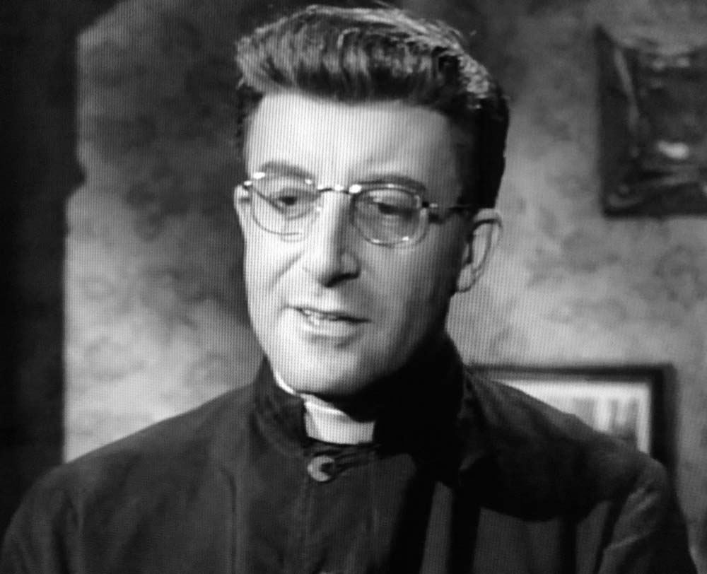
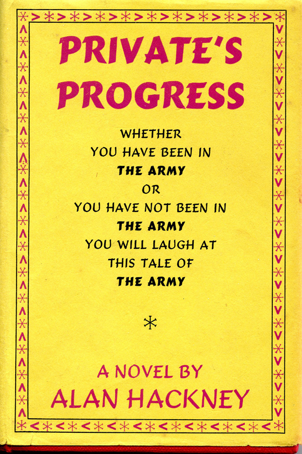


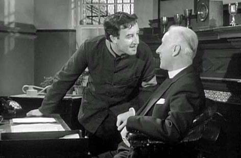


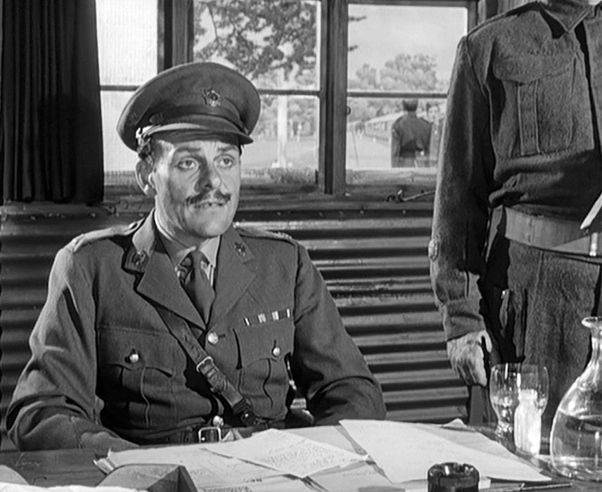


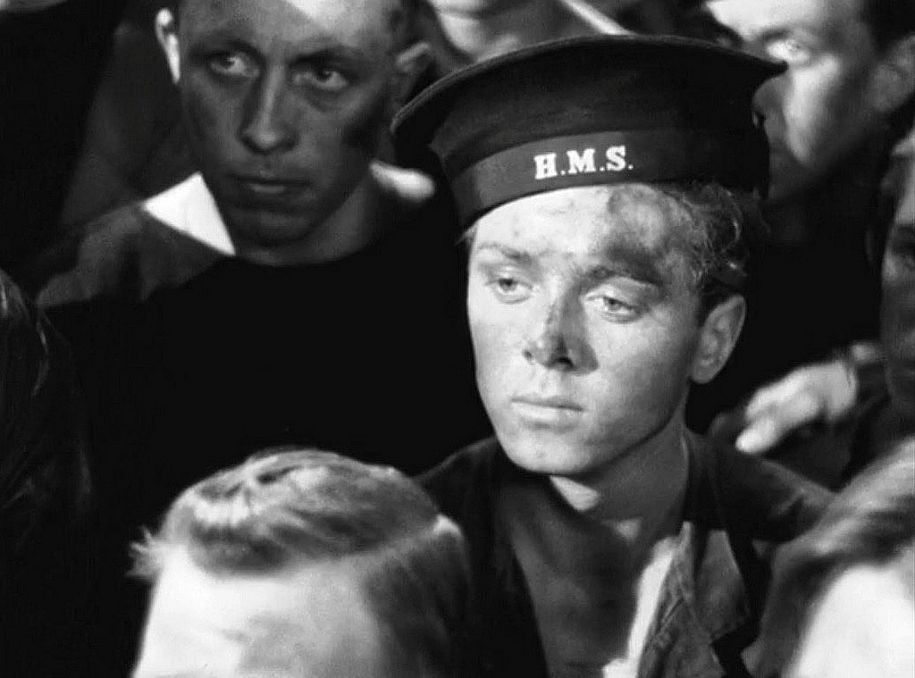

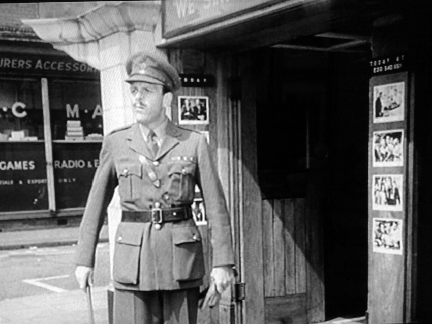

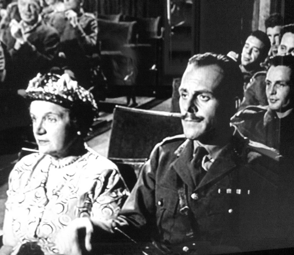


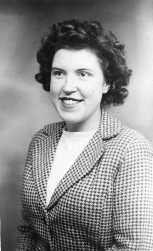


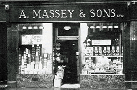


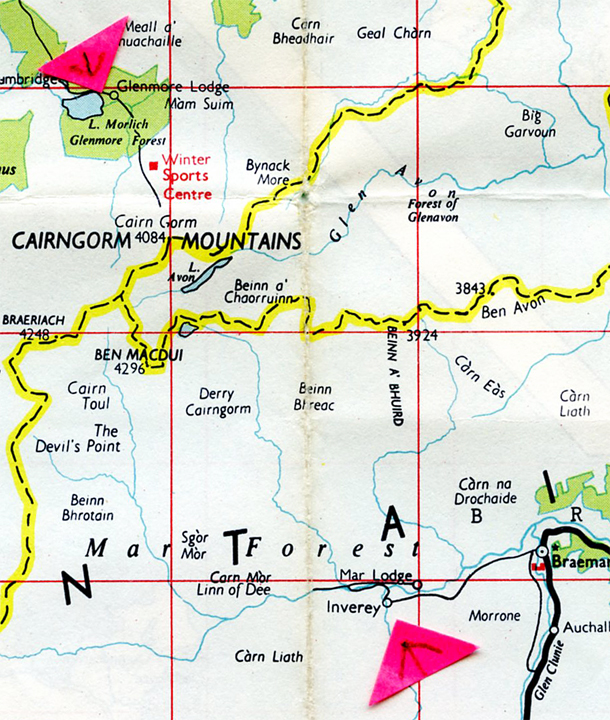


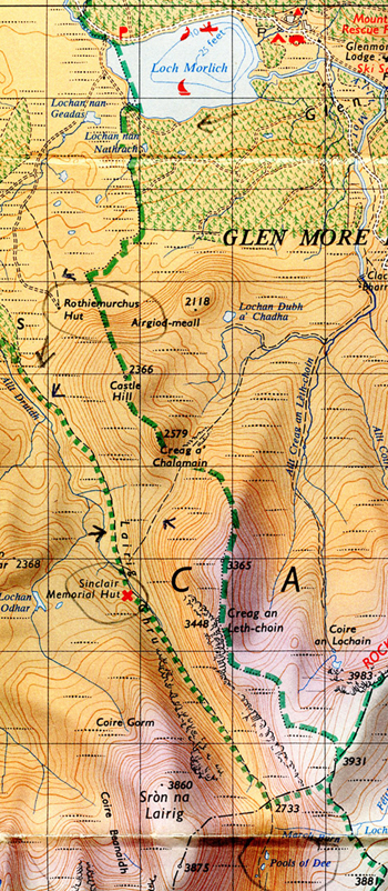


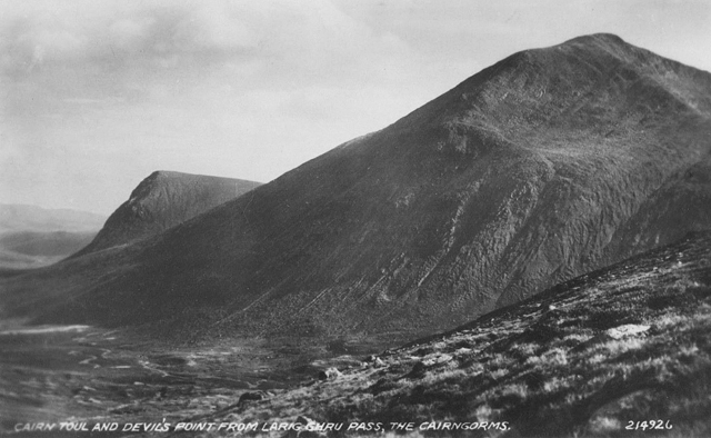


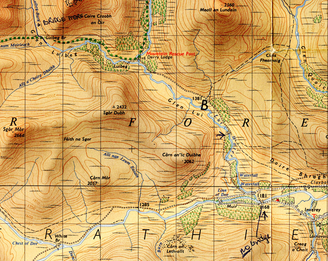


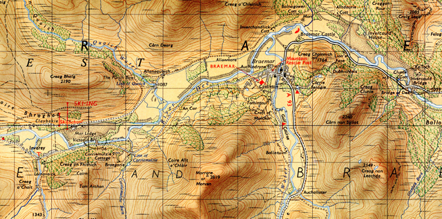
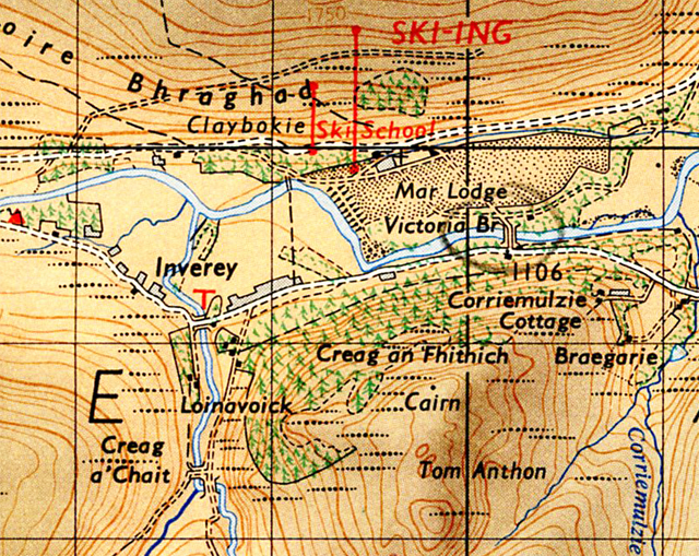
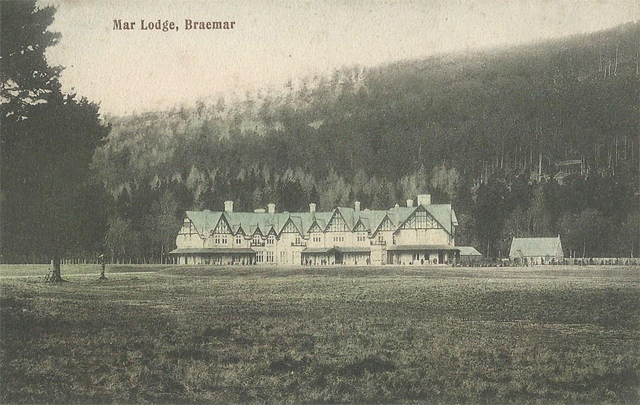
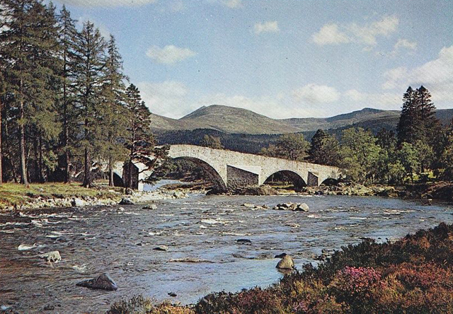
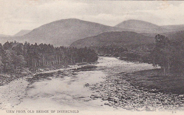
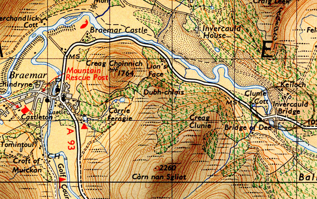

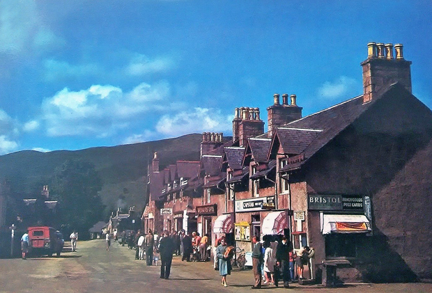


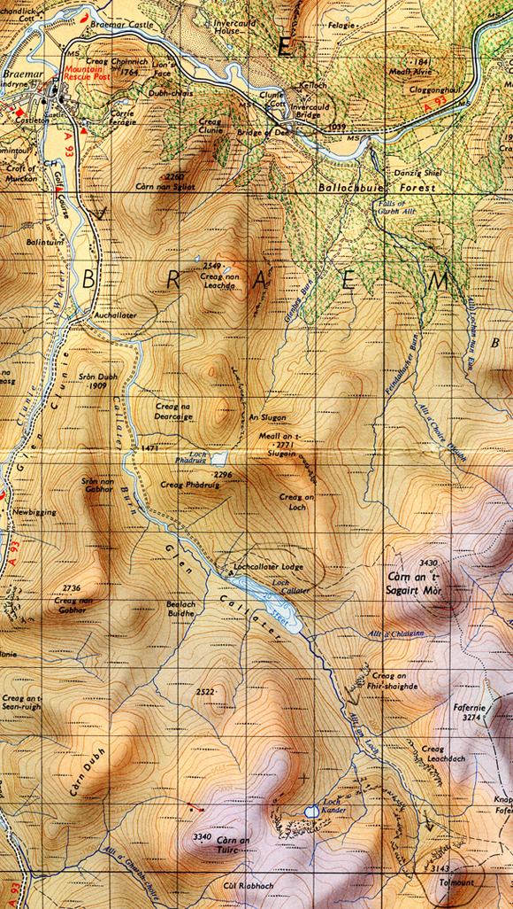
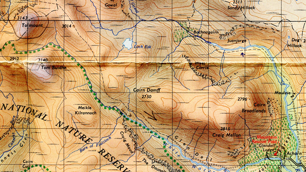

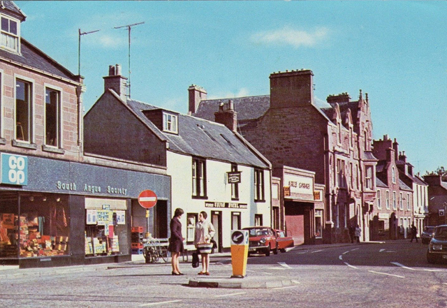
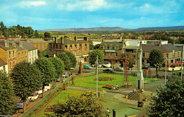
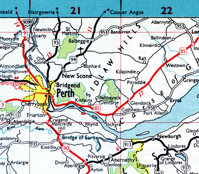


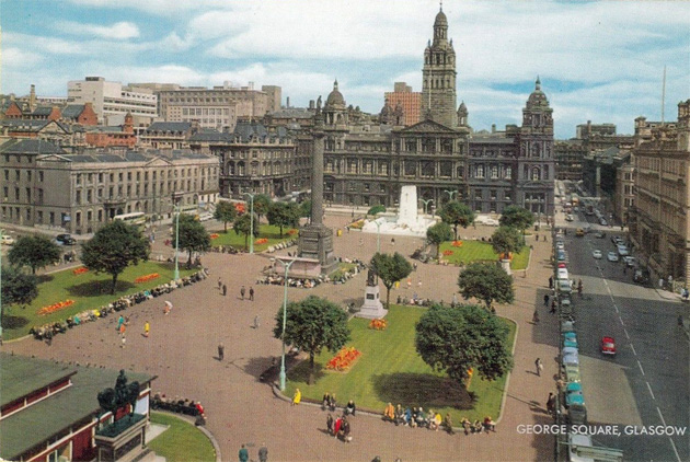


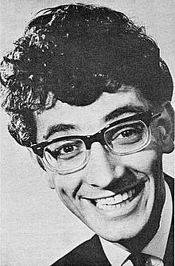


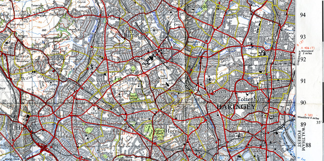


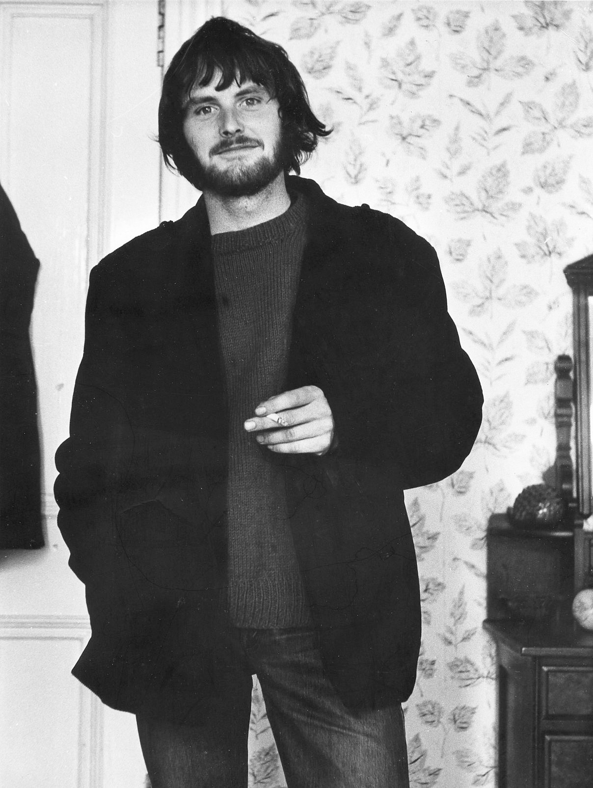
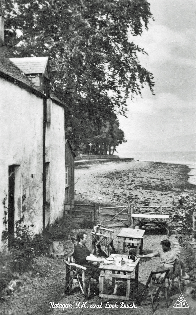


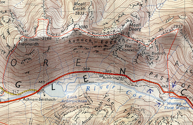
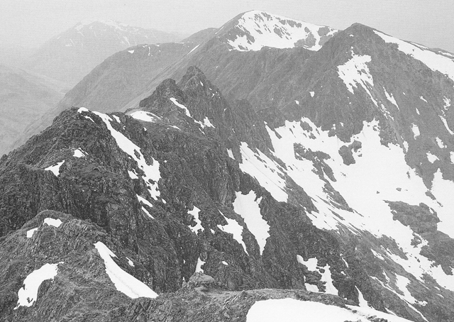
 A
A